Meall nan Gabhar

Island in Cromartyshire

Scotland

Meall nan Gabhar

Broch by Achlochan Looking east over the walls of the broch towards Polglass, early evening
Broch by Achlochan Credit: Lesley O'Hare

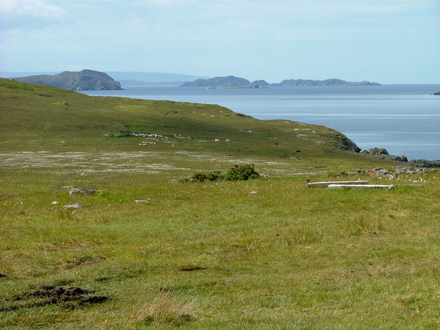
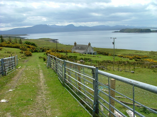
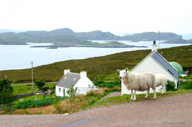
Meall nan Gabhar is a small island located in Cromartyshire, Scotland. It is situated in the Cromarty Firth, a bay on the east coast of the Scottish Highlands. This uninhabited island covers an area of approximately 0.2 square kilometers and reaches a maximum elevation of 40 meters.

The island is known for its rugged and rocky terrain, with steep cliffs surrounding its coastline. It is home to a variety of bird species, including gulls, cormorants, and puffins, making it a popular spot for birdwatching enthusiasts.

Access to Meall nan Gabhar is limited due to its remote location and lack of infrastructure. The island can only be reached by boat, and visitors are advised to take caution when navigating the treacherous waters surrounding the island.

Despite its small size, Meall nan Gabhar holds historical significance. It was once used as a grazing ground for sheep and cattle, and remnants of old stone walls can still be seen in some areas. The island also served as a lookout point during World War II, and remnants of military structures can still be found.

Meall nan Gabhar offers visitors a chance to experience the untamed beauty of Scotland's coastline. Its breathtaking views, diverse wildlife, and historical remnants make it a must-visit destination for nature lovers and history enthusiasts alike.

If you have any feedback on the listing, please let us know in the comments section below.

Meall nan Gabhar Images

Images are sourced within 2km of 57.995168/-5.3483813 or Grid Reference NC0205. Thanks to Geograph Open Source API. All images are credited.

Broch by Achlochan Looking east over the walls of the broch towards Polglass, early evening
Broch by Achlochan
Looking east over the walls of the broch towards Polglass, early evening
Fishing boat returning to Badentarbat in the evening From our campsite at Badenscallie we watched the slow progress of the boat returning home.  Shortly the boat will reach the one-mile wide strait between Rubha Dubh on Tannara Mòr and Rubha Dùnan on the mainland.
Fishing boat returning to Badentarbat in the evening
From our campsite at Badenscallie we watched the slow progress of the boat returning home. Shortly the boat will reach the one-mile wide strait between Rubha Dubh on Tannara Mòr and Rubha Dùnan on the mainland.
From Achiltibuie across Horse Sound An Teallach way in the distance
From Achiltibuie across Horse Sound
An Teallach way in the distance
Achlochan House and ruin viewed from Achiltibuie Community Hall.
Achlochan
House and ruin viewed from Achiltibuie Community Hall.
Achiltibuie croftland Overlooking the Summer Isles.
Achiltibuie croftland
Overlooking the Summer Isles.
Old barn at Polglass With a view to the Summer Isles.
Old barn at Polglass
With a view to the Summer Isles.
Track to a croft house At Polglass.
Track to a croft house
At Polglass.
Badenscallie A small settlement overlooking Horse Sound and Horse Island.
Badenscallie
A small settlement overlooking Horse Sound and Horse Island.
Farm building at Badenscallie
Croft house at Badenscallie The white painted part is lived in while the other half is used for storage.
Croft house at Badenscallie
The white painted part is lived in while the other half is used for storage.
Old and older A group of dilapidated croft buildings to the rear with a ruin in front.
Old and older
A group of dilapidated croft buildings to the rear with a ruin in front.
Track to croft buildings Badenscallie.
Track to croft buildings
Badenscallie.
Ruin by the shore On Horse Sound at Badenscallie.
Ruin by the shore
On Horse Sound at Badenscallie.
Beach on Horse Sound At Badenscallie.
Beach on Horse Sound
At Badenscallie.
Beach on Horse Sound Looking towards Tannara Mòr.
Beach on Horse Sound
Looking towards Tannara Mòr.
Badenscallie Looking northeast from the shore of Horse Sound.
Badenscallie
Looking northeast from the shore of Horse Sound.
Ruin near Badenscallie Looks to have been a quite substantial building at one time.
Ruin near Badenscallie
Looks to have been a quite substantial building at one time.
Burial ground at Badenscallie
Show me another place!

Meall nan Gabhar is located at Grid Ref: NC0205 (Lat: 57.995168, Lng: -5.3483813)

Unitary Authority: Highland

Police Authority: Highlands and Islands

What 3 Words

///shovels.stated.speaking. Near Ullapool, Highland

Related Wikis

Horse Island, Summer Isles

Horse Island (Scottish Gaelic: Eilean nan Each) is an uninhabited island in the Summer Isles, in the north west of Scotland. Once inhabited, the island...

Polglass

Polglass (Scottish Gaelic: Am Poll Glas) is a long crofting township, lying on the north shore of the sea loch, Loch Broom in Ullapool Ross-shire, Scottish...

Achiltibuie

Achiltibuie (; Scottish Gaelic: Achd Ille Bhuidhe or Field of the yellow-haired boy) is a long linear village in Ross and Cromarty, Highland, on the Coigach...

Coigach

Coigach (Scottish Gaelic: A' Chòigeach) is a peninsula north of Ullapool, in Wester Ross in the Northwest Highlands of Scotland. The area consists of a...

Badentarbat Bay

Badentarbat Bay, or Badentarbet Bay, is a bay in northern Scotland. The village of Achiltibuie overlooks it. Marian Leven painted scenes of the bay....

Achduart

Achduart (Gaelic: Achadh Dhubhaird) is a coastal hamlet in Coigach, Wester Ross in northwestern Scotland, now within the Highland council area. It is situated...

Tanera Mòr

Tanera Mòr (Scottish Gaelic: Tannara Mòr) is a sporadically inhabited island in Loch Broom in the Inner Hebrides of Scotland, the largest of the Summer...

Polbain

Polbain is a remote crofting township, located on the north Badentarbat Bay on the west coast of Scotland, in western Ross-shire, Scottish Highlands and...

Nearby Amenities

Located within 500m of 57.995168,-5.3483813
Created By: almien_coastlines
Source: PGS
Lat/Long: 57.991295/-5.349208
Created By: almien_coastlines
Source: PGS
Lat/Long: 57.99156/-5.348743
Created By: almien_coastlines
Source: PGS
Lat/Long: 57.991816/-5.34876
Created By: almien_coastlines
Source: PGS
Lat/Long: 57.991939/-5.349008
Created By: almien_coastlines
Source: PGS
Lat/Long: 57.992177/-5.349988
Created By: almien_coastlines
Source: PGS
Lat/Long: 57.992301/-5.350239
Created By: almien_coastlines
Source: PGS
Lat/Long: 57.993064/-5.350529
Created By: almien_coastlines
Source: PGS
Lat/Long: 57.9932/-5.350056
Created By: almien_coastlines
Source: PGS
Lat/Long: 57.993209/-5.349574
Created By: almien_coastlines
Source: PGS
Lat/Long: 57.993862/-5.348894
Created By: almien_coastlines
Source: PGS
Lat/Long: 57.994625/-5.349184
Created By: almien_coastlines
Source: PGS
Lat/Long: 57.994607/-5.350148
Created By: almien_coastlines
Source: PGS
Lat/Long: 57.995123/-5.349941
Created By: almien_coastlines
Source: PGS
Lat/Long: 57.995639/-5.349733
Created By: almien_coastlines
Source: PGS
Lat/Long: 57.995493/-5.350688
Created By: almien_coastlines
Source: PGS
Lat/Long: 57.995484/-5.35117
Created By: almien_coastlines
Source: PGS
Lat/Long: 57.995608/-5.35142
Created By: almien_coastlines
Source: PGS
Lat/Long: 57.995731/-5.351668
Created By: almien_coastlines
Source: PGS
Lat/Long: 57.99585/-5.352158
Created By: almien_coastlines
Source: PGS
Lat/Long: 57.996362/-5.352192
Created By: almien_coastlines
Source: PGS
Lat/Long: 57.996371/-5.35171
Created By: almien_coastlines
Source: PGS
Lat/Long: 57.996882/-5.351744
Created By: almien_coastlines
Source: PGS
Lat/Long: 57.997019/-5.35127
Created By: almien_coastlines
Source: PGS
Lat/Long: 57.997283/-5.350805
Created By: almien_coastlines
Source: PGS
Lat/Long: 57.997557/-5.349859
Created By: almien_coastlines
Source: PGS
Lat/Long: 57.997566/-5.349377
Created By: almien_coastlines
Source: PGS
Lat/Long: 57.997319/-5.348879
Created By: almien_coastlines
Source: PGS
Lat/Long: 57.997328/-5.348397
Created By: almien_coastlines
Source: PGS
Lat/Long: 57.997465/-5.347924
Created By: almien_coastlines
Source: PGS
Lat/Long: 57.997214/-5.347667
Created By: almien_coastlines
Source: PGS
Lat/Long: 57.996967/-5.347168
Created By: almien_coastlines
Source: PGS
Lat/Long: 57.99672/-5.34667
Created By: almien_coastlines
Source: PGS
Lat/Long: 57.996473/-5.346172
Created By: almien_coastlines
Source: PGS
Lat/Long: 57.996226/-5.345673
Created By: almien_coastlines
Source: PGS
Lat/Long: 57.995979/-5.345175
Created By: almien_coastlines
Source: PGS
Lat/Long: 57.994454/-5.344592
Created By: almien_coastlines
Source: PGS
Lat/Long: 57.993942/-5.344559
Created By: almien_coastlines
Source: PGS
Lat/Long: 57.993426/-5.344766
Created By: almien_coastlines
Source: PGS
Lat/Long: 57.99328/-5.345721
Created By: almien_coastlines
Source: PGS
Lat/Long: 57.993006/-5.346667
Created By: almien_coastlines
Source: PGS
Lat/Long: 57.992785/-5.346971
Source: PGS
Lat/Long: 57.9932832/-5.3488493
Source: PGS
Lat/Long: 57.9923847/-5.3466177
Created By: almien_coastlines
Source: PGS
Lat/Long: 57.991874/-5.345629
Created By: almien_coastlines
Source: PGS
Lat/Long: 57.991754/-5.345138
Created By: almien_coastlines
Source: PGS
Lat/Long: 57.991763/-5.344657
Created By: almien_coastlines
Source: PGS
Lat/Long: 57.991781/-5.343694
Created By: almien_coastlines
Source: PGS
Lat/Long: 57.992183/-5.342755
Created By: almien_coastlines
Source: PGS
Lat/Long: 57.992191/-5.342274
Source: PGS
Lat/Long: 57.9928169/-5.3473043
Source: PGS
Lat/Long: 57.9924985/-5.3472614
The data included in this document is from www.openstreetmap.org. The data is made available under ODbL.

Have you been to Meall nan Gabhar?

Leave your review of Meall nan Gabhar below (or comments, questions and feedback).