An Sgonn

Island in Ross-shire

Scotland

An Sgonn

A832 near Gruinard Bay
A832 near Gruinard Bay Credit: Alan Reid

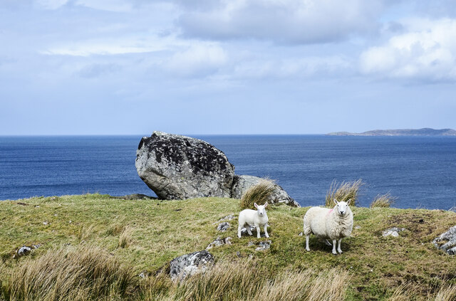
An Sgonn is a small island located in Ross-shire, Scotland. Situated off the west coast of Scotland, it is part of the Inner Hebrides archipelago. The island spans a total area of approximately 2 square kilometers and is known for its natural beauty and rugged landscape.

An Sgonn is characterized by its rocky coastline, which is dotted with small sandy beaches and picturesque coves. The island is mostly uninhabited, with only a handful of small cottages scattered across its terrain. Its remote location and minimal human interference have allowed the island's ecosystem to thrive, making it a haven for wildlife enthusiasts and nature lovers.

The island boasts a diverse range of flora and fauna, including various seabirds, otters, and seals. It is also home to a number of rare plant species, making it a designated Site of Special Scientific Interest (SSSI). The surrounding waters are rich in marine life, attracting divers and snorkelers who are keen to explore the underwater world.

An Sgonn can be accessed by boat from nearby coastal towns, such as Ullapool, which is approximately 10 kilometers away. The island offers opportunities for outdoor activities, including hiking, birdwatching, and fishing. Visitors can enjoy breathtaking views of the surrounding sea and neighboring islands from the island's highest point, which stands at around 100 meters above sea level.

Overall, An Sgonn is a hidden gem for those seeking tranquility and natural beauty. Its untouched landscape and abundant wildlife make it a must-visit destination for nature enthusiasts and adventurers.

If you have any feedback on the listing, please let us know in the comments section below.

An Sgonn Images

Images are sourced within 2km of 57.861266/-5.498472 or Grid Reference NG9291. Thanks to Geograph Open Source API. All images are credited.

A832 near Gruinard Bay
Track heading into the hills The track leaves the A832 and meanders for about 7 kilometres to Eileach Mhic 'ille Riabhaich
Track heading into the hills
The track leaves the A832 and meanders for about 7 kilometres to Eileach Mhic 'ille Riabhaich
Descent to Little Gruinard Bay Amidst dramatic scenery the A832 descends to the head of Little Gruinard Bay.
Descent to Little Gruinard Bay
Amidst dramatic scenery the A832 descends to the head of Little Gruinard Bay.
Ruin at First Coast
Ruin at First Coast
Gruinard Bay
Gruinard Bay
A foxglove at Gruinard Bay The foxglove (Digitalis purpurea) is a beautiful but poisonous flower common throughout Britain. I isolated the foxglove against the sea for a uniform background. For a wider view, see <a href="https://www.geograph.org.uk/photo/5834969">NG9291 : Gruinard Bay</a>.
A foxglove at Gruinard Bay
The foxglove (Digitalis purpurea) is a beautiful but poisonous flower common throughout Britain. I isolated the foxglove against the sea for a uniform background. For a wider view, see NG9291 : Gruinard Bay.
The A832 between First Coast and Second Coast This route is popular with motor cyclists.
The A832 between First Coast and Second Coast
This route is popular with motor cyclists.
Wester Ross coastal scenery at First Coast A favourite of many a calendar. In the distance lie the line of hills extending from Sàil Mhòr to An Teallach.
Wester Ross coastal scenery at First Coast
A favourite of many a calendar. In the distance lie the line of hills extending from Sàil Mhòr to An Teallach.
House  alongside  the A832  at  First  Coast A small number of spread out properties make up First Coast, with the same further along being Second Coast.
House alongside the A832 at First Coast
A small number of spread out properties make up First Coast, with the same further along being Second Coast.
Looking  over  Gruinard  Bay  from  A832 Gruinard Island to the right
Looking over Gruinard Bay from A832
Gruinard Island to the right
Rising  to  the summit  A832  at  Creag  Mhor
Rising to the summit A832 at Creag Mhor
A832  toward  Laide
A832 toward Laide
Sheep with lamb and boulders The animals are beside the A832 at Second Coast. Gruinard Bay is beyond the boulders with part of Gruinard Island in view at the right side of the image.
Sheep with lamb and boulders
The animals are beside the A832 at Second Coast. Gruinard Bay is beyond the boulders with part of Gruinard Island in view at the right side of the image.
A832 The A832 runs 127 miles from the Black Isle to Braemore Junction <a href="https://www.geograph.org.uk/photo/7232275">NH2077 : Braemore Junction</a>.
<span class="nowrap"><a title="https://www.sabre-roads.org.uk/wiki/index.php?title=A832" rel="nofollow ugc noopener" href="https://www.sabre-roads.org.uk/wiki/index.php?title=A832">Link</a><img style="margin-left:2px;" alt="External link" title="External link - shift click to open in new window" src="https://s1.geograph.org.uk/img/external.png" width="10" height="10"/></span>
A832
The A832 runs 127 miles from the Black Isle to Braemore Junction NH2077 : Braemore Junction. LinkExternal link
A832, Second Coast The A832 runs 127 miles from the Black Isle to Braemore Junction <a href="https://www.geograph.org.uk/photo/7232275">NH2077 : Braemore Junction</a>.
<span class="nowrap"><a title="https://www.sabre-roads.org.uk/wiki/index.php?title=A832" rel="nofollow ugc noopener" href="https://www.sabre-roads.org.uk/wiki/index.php?title=A832">Link</a><img style="margin-left:2px;" alt="External link" title="External link - shift click to open in new window" src="https://s1.geograph.org.uk/img/external.png" width="10" height="10"/></span>
A832, Second Coast
The A832 runs 127 miles from the Black Isle to Braemore Junction NH2077 : Braemore Junction. LinkExternal link
A832, Second Coast The North Coast 500 is a 516 mile scenic route around the north coast of Scotland, starting and ending at Inverness Castle. The route is also known as the NC500 and was launched in 2015, linking many features in the north Highlands of Scotland in one touring route.
The route has increased visitor numbers to parts of the north of Scotland, which has brought economic benefits to some areas. The increase in traffic has also led to more instances of bad and dangerous driving, as well as damage to the roads and concerns about the environmental impact. 
Apparently the route was amended in 2022 with detours etc being removed.
Wikipedia: <span class="nowrap"><a title="https://en.wikipedia.org/wiki/North_Coast_500" rel="nofollow ugc noopener" href="https://en.wikipedia.org/wiki/North_Coast_500">Link</a><img style="margin-left:2px;" alt="External link" title="External link - shift click to open in new window" src="https://s1.geograph.org.uk/img/external.png" width="10" height="10"/></span> 
Original route map: <span class="nowrap"><a title="https://en.wikipedia.org/wiki/North_Coast_500#/media/File:North_Coast_500,_Scotland.svg" rel="nofollow ugc noopener" href="https://en.wikipedia.org/wiki/North_Coast_500#/media/File:North_Coast_500,_Scotland.svg">Link</a><img style="margin-left:2px;" alt="External link" title="External link - shift click to open in new window" src="https://s1.geograph.org.uk/img/external.png" width="10" height="10"/></span> 
Latest route map: <span class="nowrap"><a title="https://www.northcoast500.com/explore-the-route/" rel="nofollow ugc noopener" href="https://www.northcoast500.com/explore-the-route/">Link</a><img style="margin-left:2px;" alt="External link" title="External link - shift click to open in new window" src="https://s1.geograph.org.uk/img/external.png" width="10" height="10"/></span>
A832, Second Coast
The North Coast 500 is a 516 mile scenic route around the north coast of Scotland, starting and ending at Inverness Castle. The route is also known as the NC500 and was launched in 2015, linking many features in the north Highlands of Scotland in one touring route. The route has increased visitor numbers to parts of the north of Scotland, which has brought economic benefits to some areas. The increase in traffic has also led to more instances of bad and dangerous driving, as well as damage to the roads and concerns about the environmental impact. Apparently the route was amended in 2022 with detours etc being removed. Wikipedia: LinkExternal link Original route map: LinkExternal link Latest route map: LinkExternal link
A832, First Coast The A832 runs 127 miles from the Black Isle to Braemore Junction <a href="https://www.geograph.org.uk/photo/7232275">NH2077 : Braemore Junction</a>.
<span class="nowrap"><a title="https://www.sabre-roads.org.uk/wiki/index.php?title=A832" rel="nofollow ugc noopener" href="https://www.sabre-roads.org.uk/wiki/index.php?title=A832">Link</a><img style="margin-left:2px;" alt="External link" title="External link - shift click to open in new window" src="https://s1.geograph.org.uk/img/external.png" width="10" height="10"/></span>
A832, First Coast
The A832 runs 127 miles from the Black Isle to Braemore Junction NH2077 : Braemore Junction. LinkExternal link
Show me another place!

An Sgonn is located at Grid Ref: NG9291 (Lat: 57.861266, Lng: -5.498472)

Unitary Authority: Highland

Police Authority: Highlands and Islands

What 3 Words

///snap.bookcases.imperious. Near Gairloch, Highland

Nearby Locations

First Coast An Sgonn

Related Wikis

First Coast, Highland

First Coast is a small settlement in Wester Ross in the North West Highlands of Scotland. It is situated on the south shore of Gruinard Bay and on the...

Sand, Highland

Sand (Scottish Gaelic: Sannda) is a small hamlet, located on the southern shore of Gruinard Bay, and lying to the west of the village of Laide in Ross...

Laide

Laide (Scottish Gaelic: An Leathad) is a small village in the northwest of the Highlands of Scotland. It is situated on the southern shore of Gruinard...

Gruinard Bay

Gruinard Bay is a large remote coastal embayment, located 12 miles north of Poolewe, in northwestern Ross and Cromarty, and is in the former parish of...

Nearby Amenities

Located within 500m of 57.861266,-5.498472
Source: PGS
Lat/Long: 57.861038/-5.4933621
Source: PGS
Lat/Long: 57.8612721/-5.4931699
Source: PGS
Lat/Long: 57.8612352/-5.4935144
Source: PGS
Lat/Long: 57.8609721/-5.4941095
Source: PGS
Lat/Long: 57.8612221/-5.4944547
Created By: almien_coastlines
Source: PGS
Lat/Long: 57.861096/-5.495672
Created By: almien_coastlines
Source: PGS
Lat/Long: 57.861342/-5.49617
Created By: almien_coastlines
Source: PGS
Lat/Long: 57.861314/-5.497609
Created By: almien_coastlines
Source: PGS
Lat/Long: 57.861177/-5.49808
Source: PGS
Lat/Long: 57.8619007/-5.4980331
Source: PGS
Lat/Long: 57.8616785/-5.4981626
Source: PGS
Lat/Long: 57.8613638/-5.4993002
Created By: almien_coastlines
Source: PGS
Lat/Long: 57.861276/-5.499529
Source: PGS
Lat/Long: 57.8613722/-5.5006212
Created By: almien_coastlines
Source: PGS
Lat/Long: 57.861504/-5.500986
Source: PGS
Lat/Long: 57.8617548/-5.5018457
Source: PGS
Lat/Long: 57.8622072/-5.5024077
Source: PGS
Lat/Long: 57.8620912/-5.5029423
Source: PGS
Lat/Long: 57.862121/-5.5037681
Source: PGS
Lat/Long: 57.8619392/-5.5041565
Source: PGS
Lat/Long: 57.8617129/-5.5052151
First Coast
Alt Name Gd: An t-Oirthir Shìos
Name En: First Coast
Name Gd: An t-Eirthire Shìos
Place: hamlet
Lat/Long: 57.860102/-5.5023336
Power: pole
Lat/Long: 57.857221/-5.4954555
Power: pole
Lat/Long: 57.85777/-5.4958176
Power: pole
Lat/Long: 57.8583023/-5.4961329
Power: pole
Lat/Long: 57.858613/-5.4972581
Power: pole
Lat/Long: 57.858785/-5.4979551
Power: pole
Lat/Long: 57.8590128/-5.498796
Power: pole
Lat/Long: 57.8593214/-5.4999952
Power: pole
Lat/Long: 57.8595141/-5.50165
Power: pole
Lat/Long: 57.8596901/-5.5033008
Power: pole
Lat/Long: 57.8598714/-5.504936
Power: pole
Lat/Long: 57.8600536/-5.5066161
The data included in this document is from www.openstreetmap.org. The data is made available under ODbL.

Have you been to An Sgonn?

Leave your review of An Sgonn below (or comments, questions and feedback).