Brimstone Rock

Island in Pembrokeshire

Wales

Brimstone Rock

Freshwater West
Freshwater West Credit: welshbabe

Brimstone Rock, located off the coast of Pembrokeshire, is a small uninhabited island known for its rugged beauty and unique geological features. It is situated in the Celtic Sea, approximately 2.5 kilometers west of the mainland, and covers an area of around 0.4 hectares.

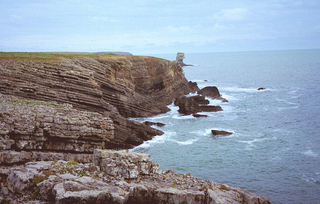
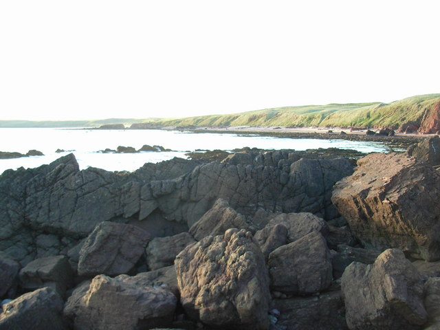
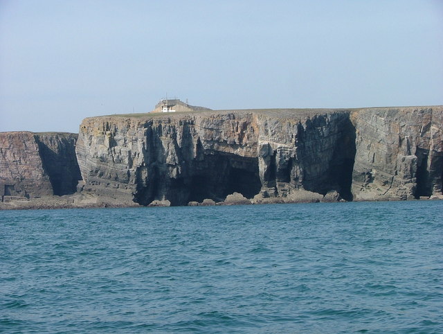
The island gets its name from the distinctive yellowish-orange color of its cliffs, which are composed of limestone and sandstone. These cliffs rise steeply from the sea, reaching a height of approximately 30 meters at their highest point. They are renowned for their impressive rock formations, including caves, arches, and stacks, which have been sculpted over millions of years by the relentless force of the sea.

Brimstone Rock is a haven for a diverse range of bird species, serving as an important nesting site during the breeding season. Puffins, razorbills, and guillemots can be spotted perched on the cliff ledges, while gulls and fulmars soar overhead. The island is also home to a small colony of grey seals, which can often be seen basking on the rocky shores or swimming in the surrounding waters.

Due to its remote location and lack of infrastructure, Brimstone Rock is inaccessible to the general public. However, boat trips and guided tours are occasionally organized from nearby coastal towns, providing visitors with an opportunity to admire the island's natural splendor and observe its abundant wildlife. The island is protected as a nature reserve, ensuring the preservation of its unique ecosystem and geological heritage.

If you have any feedback on the listing, please let us know in the comments section below.

Brimstone Rock Images

Images are sourced within 2km of 51.629969/-5.0640786 or Grid Reference SR8896. Thanks to Geograph Open Source API. All images are credited.

Freshwater West
Freshwater West
Western Walls Far, western, end of the artillery ranges at Castlemartin.  New routing on juggy limestone. One of the best easy end climbing crags anywhere.
Western Walls
Far, western, end of the artillery ranges at Castlemartin. New routing on juggy limestone. One of the best easy end climbing crags anywhere.
Western Walls Belle Tent, a route on the Western Walls, north of Linney Head. Shows the horizontal bedded limestone well.
Western Walls
Belle Tent, a route on the Western Walls, north of Linney Head. Shows the horizontal bedded limestone well.
Pen-y-holt Bay. Folded limestone beds east of Linney Head.
Pen-y-holt Bay.
Folded limestone beds east of Linney Head.
Choughs Taking no notice of the Military Firing Range warning on the clifftop.
Choughs
Taking no notice of the Military Firing Range warning on the clifftop.
Frainslake Sands
Frainslake Sands
Hanging Tar Part of MOD Castlemartin tank firing range. Special pedestrian access only and very occasionally, and vessels shepherded to a safe distance out to sea by range safety vessels when range is in use.
Hanging Tar
Part of MOD Castlemartin tank firing range. Special pedestrian access only and very occasionally, and vessels shepherded to a safe distance out to sea by range safety vessels when range is in use.
Linney Head Part of restricted area of Castlemartin tank firing range
Linney Head
Part of restricted area of Castlemartin tank firing range
Zawn at Linney Head The cliff is part of the aptly named Strata Walls.
Zawn at Linney Head
The cliff is part of the aptly named Strata Walls.
Military road in Range West The two plant pots are information carriers. The red one shows the limit of a bird nesting climbing restriction, and the yellow one shows the adjacent cliff name.
Military road in Range West
The two plant pots are information carriers. The red one shows the limit of a bird nesting climbing restriction, and the yellow one shows the adjacent cliff name.
Looking across Wind Bay
Wind Bay at high tide
Frainslake Sands, northern end
Crater in Linney Burrows The land here has been a military firing range for over 70 years and is littered with evidence of this.
Crater in Linney Burrows
The land here has been a military firing range for over 70 years and is littered with evidence of this.
Sands at Blucks Pool
Coastal heathland near Gupton Farm This land is environmentally important as it is on the military range and does not get fertiliser or any other agricultural treatment. However, it is still used for cattle grazing when not in use by the military.
Coastal heathland near Gupton Farm
This land is environmentally important as it is on the military range and does not get fertiliser or any other agricultural treatment. However, it is still used for cattle grazing when not in use by the military.
Strata Walls These cliffs are named for the regularly spaced bedding planes. The rock in the foreground is loose & crumbly, but the grey rock is quite solid.
Strata Walls
These cliffs are named for the regularly spaced bedding planes. The rock in the foreground is loose & crumbly, but the grey rock is quite solid.
Crater on the cliff top Castlemartin Range has many bomb/shell craters. The person standing on the far side gives an idea of the size of this one.
Crater on the cliff top
Castlemartin Range has many bomb/shell craters. The person standing on the far side gives an idea of the size of this one.
Show me another place!

Brimstone Rock is located at Grid Ref: SR8896 (Lat: 51.629969, Lng: -5.0640786)

Unitary Authority: Pembrokeshire

Police Authority: Dyfed Powys

What 3 Words

///enhancement.hindering.narrow. Near Castlemartin, Pembrokeshire

Related Wikis

Crow Rock

Crow Rock is a rock located off of Linney Head, Pembrokeshire, in west Wales. It is considered to be a good diving location, because of its deep gullies...

Castlemartin Corse

Castlemartin Corse is a Site of Special Scientific Interest (or SSSI) in Pembrokeshire, South Wales. It has been designated as a Site of Special Scientific...

Freshwater West

Freshwater West (also known as Fresh West) is a beach near Castlemartin, Pembrokeshire in West Wales. It lies along the B4319 road and is part of the Pembrokeshire...

Church of St Michael and All Angels, Castlemartin, Pembrokeshire

The Church of St Michael and All Angels, Castlemartin, Pembrokeshire, Wales is a redundant church dating from the 13th century. A Grade I listed building...

Nearby Amenities

Located within 500m of 51.629969,-5.0640786
Hanging Tar
Place: locality
Lat/Long: 51.6289365/-5.063326
Brimstone Rock
Place: locality
Lat/Long: 51.6304843/-5.0635352
Berry Slade
Place: locality
Lat/Long: 51.6311229/-5.0613905
The data included in this document is from www.openstreetmap.org. The data is made available under ODbL.

Have you been to Brimstone Rock?

Leave your review of Brimstone Rock below (or comments, questions and feedback).