Trywn Aber-pwll

Island in Pembrokeshire

Wales

Trywn Aber-pwll

A grey day at the Blue Lagoon The Blue Lagoon to the north of Abereiddi Bay doesn't look too inviting on an overcast day. A former slate quarry with its seaward wall breached to form a small deep bay.
A grey day at the Blue Lagoon Credit: E Gammie

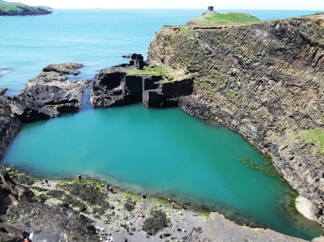
Trywn Aber-pwll, also known as the Island of Trywn Aber-pwll, is a small island located off the coast of Pembrokeshire, Wales. Situated in the Irish Sea, this island is a popular tourist destination renowned for its stunning natural beauty and rich history.

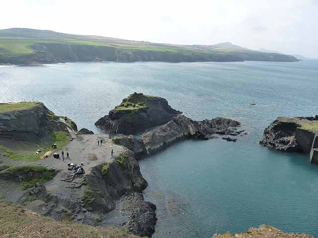
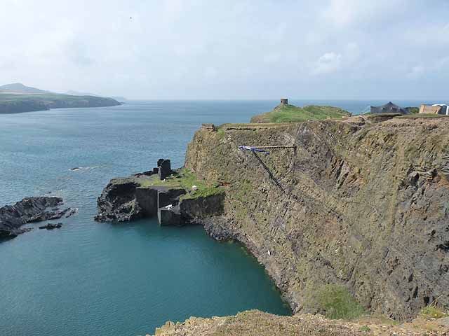
Covering an area of approximately 2 square miles, Trywn Aber-pwll is mostly characterized by rugged cliffs, rocky shores, and a diverse range of wildlife. The island is home to various bird species, including puffins, razorbills, and guillemots, making it a haven for birdwatching enthusiasts. Additionally, the surrounding waters are known for their abundant marine life, attracting divers and snorkelers who can explore the vibrant underwater world.

The island boasts a fascinating history, with evidence of human occupation dating back to the Neolithic period. Ruins of ancient settlements and burial mounds can be found scattered across the landscape. The most prominent historical feature is Trywn Aber-pwll Castle, a medieval fortress that offers panoramic views of the sea and the mainland.

Access to Trywn Aber-pwll is primarily granted via boat, with regular ferry services available from the nearby mainland. Once on the island, visitors can enjoy a range of recreational activities, including hiking, picnicking, and wildlife spotting. There are also a few accommodation options, including a campsite and self-catering cottages, providing visitors with the opportunity to experience the island's tranquility and natural beauty.

Overall, Trywn Aber-pwll is a captivating island that offers a unique blend of natural wonders and historical intrigue. From its rugged coastline to its archaeological treasures, this picturesque destination attracts visitors seeking a peaceful retreat and a glimpse into Wales' rich past.

If you have any feedback on the listing, please let us know in the comments section below.

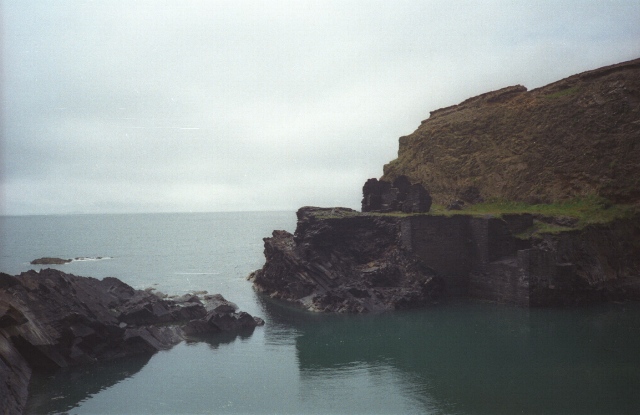
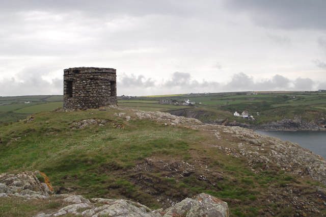
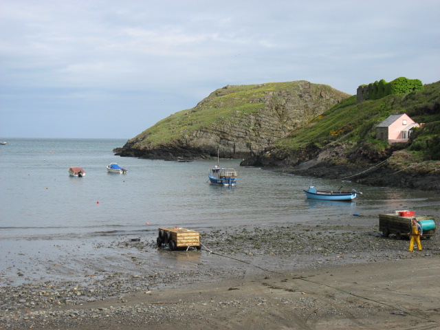
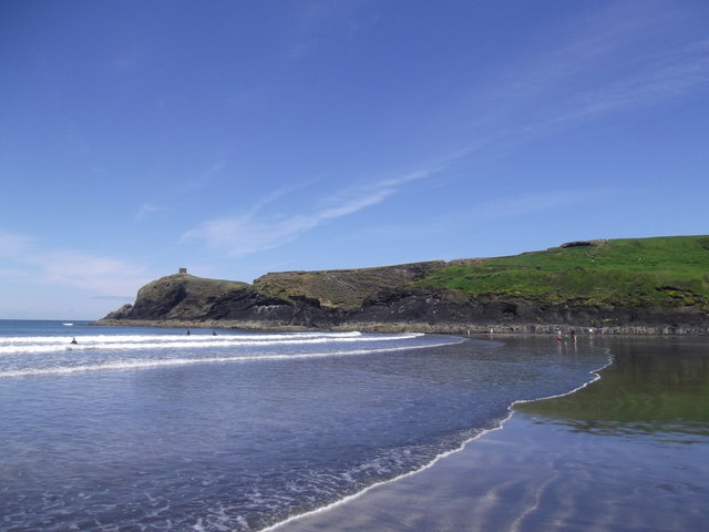
Trywn Aber-pwll Images

Images are sourced within 2km of 51.930578/-5.225174 or Grid Reference SM7830. Thanks to Geograph Open Source API. All images are credited.

A grey day at the Blue Lagoon The Blue Lagoon to the north of Abereiddi Bay doesn't look too inviting on an overcast day. A former slate quarry with its seaward wall breached to form a small deep bay.
A grey day at the Blue Lagoon
The Blue Lagoon to the north of Abereiddi Bay doesn't look too inviting on an overcast day. A former slate quarry with its seaward wall breached to form a small deep bay.
Make Hay. Pwll-caerog, looking across the fields from the Pembrokeshire Coast Path.
Make Hay.
Pwll-caerog, looking across the fields from the Pembrokeshire Coast Path.
Aber Pwll
Aber Pwll
Porth Tre-wen
Porth Tre-wen
Abereiddy Tower Situated on the Trwyncastell headland to the north of Abereiddi Bay. This tower, of uncertain usage (local information board suggests possibility of it being a meeting place for directors of the now defunct Abereiddy Slate Mine, or their ladies), lies just off the Pembrokeshire Coastal Path and gets comparatively few visitors. This is possibly because a "scramble" is required to access the headland, as coastal erosion is steadily severing the headland's link with the main peninsula.
Abereiddy Tower
Situated on the Trwyncastell headland to the north of Abereiddi Bay. This tower, of uncertain usage (local information board suggests possibility of it being a meeting place for directors of the now defunct Abereiddy Slate Mine, or their ladies), lies just off the Pembrokeshire Coastal Path and gets comparatively few visitors. This is possibly because a "scramble" is required to access the headland, as coastal erosion is steadily severing the headland's link with the main peninsula.
Abereiddi Bay
Abereiddi Bay
Abereiddy Beach Abereiddy (usual Welsh spelling: Abereiddi) is a hamlet in the county of Pembrokeshire, in south-west Wales.

It has a small beach. A large car park adjoins the beach, where in the summer an ice cream van can usually be found.
Abereiddy Beach
Abereiddy (usual Welsh spelling: Abereiddi) is a hamlet in the county of Pembrokeshire, in south-west Wales. It has a small beach. A large car park adjoins the beach, where in the summer an ice cream van can usually be found.
The Blue Lagoon The Blue Lagoon is a large disused slate quarry, now filled with seawater through a breach in the outer wall. This is 25m deep, according to a nearby Pembrokeshire National Park information board. Despite the name, the water is always a distinct greenish hue, owing to the mineral content within the quarry.

The lagoon is a favourite for adventure groups practising Coasteering.
The Blue Lagoon
The Blue Lagoon is a large disused slate quarry, now filled with seawater through a breach in the outer wall. This is 25m deep, according to a nearby Pembrokeshire National Park information board. Despite the name, the water is always a distinct greenish hue, owing to the mineral content within the quarry. The lagoon is a favourite for adventure groups practising Coasteering.
Stonechat The European Stonechat (Saxicola rubicola) breed in heathland, coastal dunes and rough grassland with scattered small shrubs and bramble, open gorse, tussocks or heather. The male's song is high and twittering like a Dunnock. Both sexes have a clicking call like stones knocking together.
Stonechat
The European Stonechat (Saxicola rubicola) breed in heathland, coastal dunes and rough grassland with scattered small shrubs and bramble, open gorse, tussocks or heather. The male's song is high and twittering like a Dunnock. Both sexes have a clicking call like stones knocking together.
Porth Tre-wen Taken from the coastal path
Porth Tre-wen
Taken from the coastal path
Castell Coch Fort
Castell Coch Fort
Ynys Gwair
Ynys Gwair
Bluebell Covered Clifftops
Aber-pwll
Aber-pwll
Caer Aber Pwll (Caerau) Iron Age Fort The complex defences at Caer Aber Pwll (Caerau) define a simple promontory fort to the east and a more heavily defended promontory fort on the west, both utilising the defensive potentials of the steep coastal cliffs. The western fort contains at least one building platform and is enclosed by a complex of up to four banks and ditches thought to represent at least two periods of construction, of uncertain relation, extending over a roughly 172m front. The main, inturned, gateway can be made out on the far side of the earthworks.

A second enclosure on the east, about 48m by 34m, may be a fragment of an early enclosure, isolated by redevelopment, an annex, or a separate and later enclosure butting onto the primary work.
Caer Aber Pwll (Caerau) Iron Age Fort
The complex defences at Caer Aber Pwll (Caerau) define a simple promontory fort to the east and a more heavily defended promontory fort on the west, both utilising the defensive potentials of the steep coastal cliffs. The western fort contains at least one building platform and is enclosed by a complex of up to four banks and ditches thought to represent at least two periods of construction, of uncertain relation, extending over a roughly 172m front. The main, inturned, gateway can be made out on the far side of the earthworks. A second enclosure on the east, about 48m by 34m, may be a fragment of an early enclosure, isolated by redevelopment, an annex, or a separate and later enclosure butting onto the primary work.
Pembrokeshire Coastal Path
The mouth of the Blue Lagoon The Blue Lagoon is an abandoned slate quarry, now flooded by the sea.
The mouth of the Blue Lagoon
The Blue Lagoon is an abandoned slate quarry, now flooded by the sea.
Cliff diving board, Blue Lagoon The Blue Lagoon is an abandoned slate quarry, now flooded by the sea. The diving board, soon to be dismantled, was installed for the Red Bull Cliff Diving Event held on the preceding two days.
Cliff diving board, Blue Lagoon
The Blue Lagoon is an abandoned slate quarry, now flooded by the sea. The diving board, soon to be dismantled, was installed for the Red Bull Cliff Diving Event held on the preceding two days.
Show me another place!

Trywn Aber-pwll is located at Grid Ref: SM7830 (Lat: 51.930578, Lng: -5.225174)

Unitary Authority: Pembrokeshire

Police Authority: Dyfed Powys

What 3 Words

///founders.reckons.soggy. Near Llanrhian, Pembrokeshire

Related Wikis

Arfordir Abereiddi

Arfordir Abereiddi is a Site of Special Scientific Interest (SSSI) in Pembrokeshire, South Wales. It has been designated as a Site of Special Scientific...

Abereiddy

Abereiddy (Welsh: Abereddi) is a hamlet in the county of Pembrokeshire, in west Wales.It has a small beach which was awarded the Blue flag rural beach...

Portheiddy Moor

Portheiddy Moor is a Site of Special Scientific Interest (or SSSI) a little to the east of Abereiddy in Pembrokeshire, South Wales. It has been designated...

Caerfarchell

Caerfarchell (Welsh pronunciation: [kaɪrvɑːrxɛɬ]) is a small village in Pembrokeshire, Wales, 3 miles northeast of St Davids, close by the A487 road. It...

Have you been to Trywn Aber-pwll?

Leave your review of Trywn Aber-pwll below (or comments, questions and feedback).