Carsaig Island

Island in Argyllshire

Scotland

Carsaig Island

Carsaig Pier
Carsaig Pier Credit: Tom Richardson

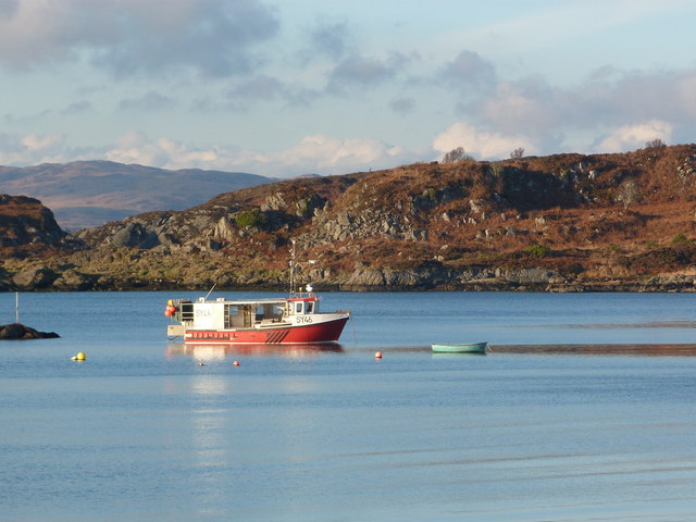
Carsaig Island is a small, uninhabited island located off the coast of Argyllshire, Scotland. It is a rocky and rugged island, with steep cliffs that rise dramatically from the sea. The island is known for its stunning natural beauty, with lush green vegetation covering much of the landscape.

Carsaig Island is home to a variety of bird species, including puffins, guillemots, and razorbills, making it a popular destination for birdwatchers. The surrounding waters are also teeming with marine life, with seals often seen basking on the rocks and dolphins and porpoises frequently spotted swimming in the sea.

Access to Carsaig Island is limited, with no regular ferry service available. However, visitors can arrange private boat trips to the island, where they can explore the rugged coastline, take in the breathtaking views, and observe the abundant wildlife.

Overall, Carsaig Island is a remote and wild destination, perfect for nature lovers and outdoor enthusiasts looking to escape the hustle and bustle of everyday life and immerse themselves in the beauty of the Scottish wilderness.

If you have any feedback on the listing, please let us know in the comments section below.

Carsaig Island Images

Images are sourced within 2km of 56.040938/-5.6429602 or Grid Reference NR7389. Thanks to Geograph Open Source API. All images are credited.

Carsaig Pier
Carsaig Pier
Boats in Carsaig Bay Boats at their moorings in Carsaig Bay, with the rocky shoreline to the left and the northern end of Jura on the horizon.
Boats in Carsaig Bay
Boats at their moorings in Carsaig Bay, with the rocky shoreline to the left and the northern end of Jura on the horizon.
Northern most tip of Eilean Traighe Southern end of Carsaig Island is on left of skyline. Picture taken at low tide.
Northern most tip of Eilean Traighe
Southern end of Carsaig Island is on left of skyline. Picture taken at low tide.
Pools on Eilean Traigh Carsaig Island and Bay in background
Pools on Eilean Traigh
Carsaig Island and Bay in background
Volcanic rock formations on Eilean Traigh Island of Jura in background
Volcanic rock formations on Eilean Traigh
Island of Jura in background
Carsaig jetty The late evening sun casts a warm light over this Thomas Telford-built jetty which often dries out at low water. There is limited safe anchorage in the outer bay. The hill in the background is the 102m Cnoc an t-Samlaidh.
Carsaig jetty
The late evening sun casts a warm light over this Thomas Telford-built jetty which often dries out at low water. There is limited safe anchorage in the outer bay. The hill in the background is the 102m Cnoc an t-Samlaidh.
Approaching sunset from Carsaig jetty The sun is beginning to set over the Sound of Jura, with the island of Jura in the distance, as viewed from the end of Carsaig jetty.
Approaching sunset from Carsaig jetty
The sun is beginning to set over the Sound of Jura, with the island of Jura in the distance, as viewed from the end of Carsaig jetty.
Carsaig Bay
Carsaig Bay
Carsaig Bay The beach at Carsaig as seen from near the jetty.
Carsaig Bay
The beach at Carsaig as seen from near the jetty.
Jetty at Carsaig
Jetty at Carsaig
Just a fit! Fishing boat repairs at Carsaig.
Just a fit!
Fishing boat repairs at Carsaig.
Fishing boat repairs at Carsaig
Boat at Carsaig Bay Upturned boat at Carsaig Bay.
Boat at Carsaig Bay
Upturned boat at Carsaig Bay.
Old dinghy by the dock at Carsaig
Fishing boat in Carsaig Bay
Rounding Rubha na h-Earba into Sailean na h-Earba Rounding the gently curving NW shore of Rubha na h-Earba gives us our first view of the islands we will pass before Carsaig Bay (our intended lunch stop). The rocky promontory now on our left is Rubha na h-Airde Loisgte. Visibility is starting to improve (earlier, cloudbase had seemed scarcly above head height) as the ebb tide assists our paddle SW down the Sound of Jura.
Rounding Rubha na h-Earba into Sailean na h-Earba
Rounding the gently curving NW shore of Rubha na h-Earba gives us our first view of the islands we will pass before Carsaig Bay (our intended lunch stop). The rocky promontory now on our left is Rubha na h-Airde Loisgte. Visibility is starting to improve (earlier, cloudbase had seemed scarcly above head height) as the ebb tide assists our paddle SW down the Sound of Jura.
Birch wood, Ardnackaig Hillside in Knapdale Forest after removal of conifers.
Birch wood, Ardnackaig
Hillside in Knapdale Forest after removal of conifers.
Pond, Ardnackaig
Pond, Ardnackaig
Show me another place!

Carsaig Island is located at Grid Ref: NR7389 (Lat: 56.040938, Lng: -5.6429602)

Unitary Authority: Argyll and Bute

Police Authority: Argyll and West Dunbartonshire

What 3 Words

///slimming.slices.belts. Near Ardrishaig, Argyll & Bute

Related Wikis

Tayvallich

Tayvallich (pronounced TAY-vee-AL-ich; Scottish Gaelic: Taigh a' Bhealaich [t̪ʰɤj ə ˈvjal̪ˠɪç]) is a small village in the Knapdale area of Argyll and Bute...

Taynish National Nature Reserve

Taynish National Nature Reserve (Scottish Gaelic: Tèarmann Nàdair Nàiseanta Taighnis) is situated southwest of the village of Tayvallich in the council...

Eilean Loain

Eilean Loain is a small island in Loch Sween and one of the Inner Hebrides of Scotland. It is about 2 kilometres (1 mi) west of the settlement of Kilmichael...

Ashfield, Argyll and Bute

Ashfield is a village in the civil parish of North Knapdale, in Knapdale, in the council area of Argyll and Bute, Scotland. It has a sheep farm and cottage...

Have you been to Carsaig Island?

Leave your review of Carsaig Island below (or comments, questions and feedback).