Sùil Ghorm

Island in Argyllshire

Scotland

Sùil Ghorm

Cairns of Coll Rocks These skerries are slightly mislabelled on the OS map as "Cairns of Coll', a name that applies to the group of small islands just to the south, including Sùil Ghorm, Eag na Maoile and Eilean Mòr.
Cairns of Coll Rocks Credit: John Allan

Sùil Ghorm is a small island located off the coast of Argyllshire in western Scotland. With a land area of approximately 2 square kilometers, it is known for its stunning natural beauty and rich history. The island is part of the Inner Hebrides archipelago and is accessible by boat from the mainland.

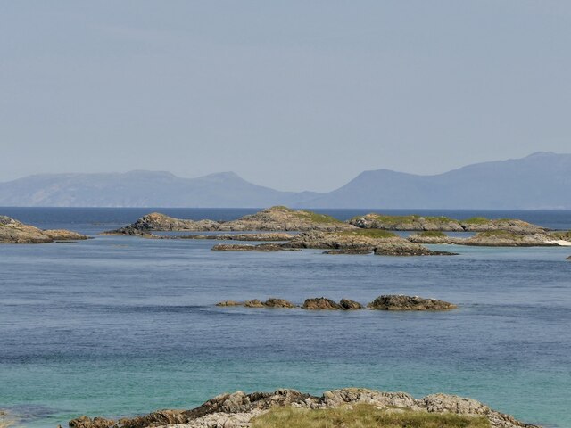
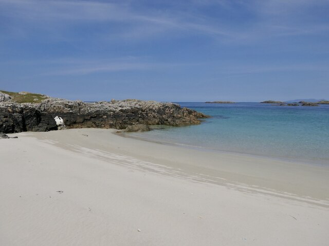
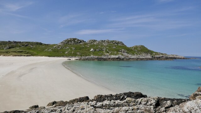
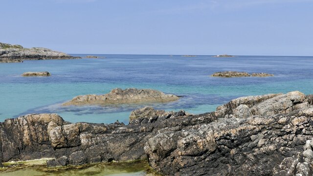
The landscape of Sùil Ghorm is characterized by rolling green hills, rugged cliffs, and picturesque sandy beaches. It is largely uninhabited, with only a handful of cottages dotting the island. The absence of modern development adds to its charm and tranquility, making it a popular destination for nature lovers and those seeking a peaceful retreat.

The island is home to a diverse range of flora and fauna, including various species of birds, seals, and marine life. It is also known for its archaeological sites, with evidence of human occupation dating back thousands of years. Visitors can explore ancient ruins, such as standing stones and burial cairns, which provide insight into the island's past.

Outdoor enthusiasts will find plenty to do on Sùil Ghorm. The island offers opportunities for hiking, birdwatching, fishing, and even water sports like kayaking and snorkeling. The surrounding waters are teeming with marine life, making it a popular spot for divers.

Overall, Sùil Ghorm offers a unique and enchanting experience for those looking to immerse themselves in the natural beauty and rich history of the Scottish Highlands.

If you have any feedback on the listing, please let us know in the comments section below.

Sùil Ghorm Images

Images are sourced within 2km of 56.704004/-6.4435577 or Grid Reference NM2865. Thanks to Geograph Open Source API. All images are credited.

Cairns of Coll Rocks These skerries are slightly mislabelled on the OS map as "Cairns of Coll', a name that applies to the group of small islands just to the south, including Sùil Ghorm, Eag na Maoile and Eilean Mòr.
Cairns of Coll Rocks
These skerries are slightly mislabelled on the OS map as "Cairns of Coll', a name that applies to the group of small islands just to the south, including Sùil Ghorm, Eag na Maoile and Eilean Mòr.
Islands off Coll Looking past a skerry off Sanna, Ardnamurchan towards Eilean Mòr and the lighthouse on Sùil Ghorm.
Islands off Coll
Looking past a skerry off Sanna, Ardnamurchan towards Eilean Mòr and the lighthouse on Sùil Ghorm.
Islands off Coll Off the north tip of Coll. The profile is very much temporary as a cruise ship was passing on the far side.
Islands off Coll
Off the north tip of Coll. The profile is very much temporary as a cruise ship was passing on the far side.
Cairns of Coll Skerries off the north tip of Coll. Rùm in the background.
Cairns of Coll
Skerries off the north tip of Coll. Rùm in the background.
Cairns of Coll Lighthouse On Sùil Ghorm with the Rùm Cuillin as a backdrop.
Cairns of Coll Lighthouse
On Sùil Ghorm with the Rùm Cuillin as a backdrop.
Eilean Mòr, Coll The largest of the Cairns of Coll islands.
Eilean Mòr, Coll
The largest of the Cairns of Coll islands.
Tràigh Tuath, Coll At higher tides there are two beaches here divided by rocks.
Tràigh Tuath, Coll
At higher tides there are two beaches here divided by rocks.
Tràigh Tuath, Coll A fine beach at the north end of Coll.
Tràigh Tuath, Coll
A fine beach at the north end of Coll.
Skerries off Tràigh Tuath, Coll
Suil Ghorm Rocks and lighthouse north east of Coll.
Suil Ghorm
Rocks and lighthouse north east of Coll.
Survey boat moored on skerries west of Eilean Mor The boat was undertaking a seal and whale-watch cruise from Tobermory to the north east tip of Coll
Survey boat moored on skerries west of Eilean Mor
The boat was undertaking a seal and whale-watch cruise from Tobermory to the north east tip of Coll
view west across skerries to the open sea photo taken on a visit to skerries off the north tip of Coll
view west across skerries to the open sea
photo taken on a visit to skerries off the north tip of Coll
Traigh Tuath, Coll The easternmost beach on Coll's north-facing coast as seen from land close to the western margin of the grid square.
Traigh Tuath, Coll
The easternmost beach on Coll's north-facing coast as seen from land close to the western margin of the grid square.
Islands off the north of Coll
Skerries off Coll A group of small rocky islands around the anchorage of Acairseid Mhòr seen from the Druim nan Carn triangulation pillar.
Skerries off Coll
A group of small rocky islands around the anchorage of Acairseid Mhòr seen from the Druim nan Carn triangulation pillar.
Eilean Mòr An island off the northern tip of Coll.
Eilean Mòr
An island off the northern tip of Coll.
Traigh Tuath, Isle of Coll The most easterly bay on the north coast of Coll.  I am grateful to Eswales and his image <a href="https://www.geograph.org.uk/photo/826169">NM2764 : Traigh Tuath, Coll</a> for pinpointing the location of my 24-year-old picture.
Traigh Tuath, Isle of Coll
The most easterly bay on the north coast of Coll. I am grateful to Eswales and his image NM2764 : Traigh Tuath, Coll for pinpointing the location of my 24-year-old picture.
View over the skerries from Garbh Aird Bheag, Isle of Coll The small light tower on Sùil Ghorm is visible in the islets off the north coast of Coll.
View over the skerries from Garbh Aird Bheag, Isle of Coll
The small light tower on Sùil Ghorm is visible in the islets off the north coast of Coll.
Show me another place!

Sùil Ghorm is located at Grid Ref: NM2865 (Lat: 56.704004, Lng: -6.4435577)

Unitary Authority: Argyll and Bute

Police Authority: Argyll and West Dunbartonshire

What 3 Words

///shots.blackmail.depend. Near Arinagour, Argyll & Bute

Related Wikis

Cairns of Coll

The Cairns of Coll refers primarily to a region of rocky outcrops in shallow waters extending from the north end of the Island of Coll in the Inner Hebrides...

Dùn Morbhaidh

Dùn Morbhaidh, also known as Dun Borbaidh, is a hill fort located on the Inner Hebridean island of Coll. The early 20th century antiquary Erskine Beveridge...

Nearby Amenities

Located within 500m of 56.704004,-6.4435577
Natural: rock
Source: OS7
Tidal: yes
Lat/Long: 56.7014833/-6.4445327
Natural: rock
Source: OS7
Tidal: yes
Lat/Long: 56.7012384/-6.4433882
Natural: rock
Source: OS7
Tidal: yes
Lat/Long: 56.7011685/-6.4426888
Seamark Light Character: Fl
Seamark Light Colour: white
Seamark Light Height: 23
Seamark Light Period: 12
Seamark Light Range: 10
Seamark Light Reference: A 4084
Seamark Light Sequence: 0.5+(11.5)
Seamark Type: light_minor
Source: US NGA Pub. 114. 2011-05-26.
Lat/Long: 56.70435/-6.44555
The data included in this document is from www.openstreetmap.org. The data is made available under ODbL.

Have you been to Sùil Ghorm?

Leave your review of Sùil Ghorm below (or comments, questions and feedback).