Sgeir Caitriona

Island in Inverness-shire

Scotland

Sgeir Caitriona

Fish Farm Pier at Loch Huamabhat
Fish Farm Pier at Loch Huamabhat Credit: Sandy Gerrard

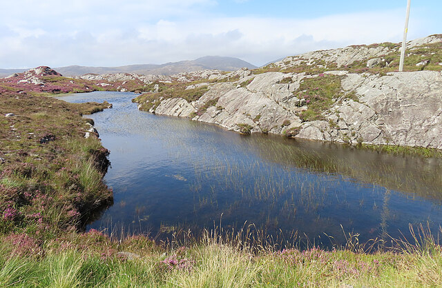
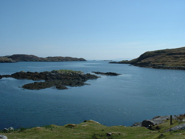
Sgeir Caitriona, also known as Caitriona Skerry, is a small rocky island located in the Sound of Raasay, off the west coast of mainland Scotland in Inverness-shire. It is situated approximately 2 kilometers northeast of the Isle of Skye. The island measures about 200 meters in length and 50 meters in width.

Sgeir Caitriona is a designated nature reserve, renowned for its rich biodiversity and important bird populations. The island is a breeding ground for several species of seabirds, including black-legged kittiwakes, northern fulmars, and guillemots. It also serves as a resting spot for various migratory birds during their journeys.

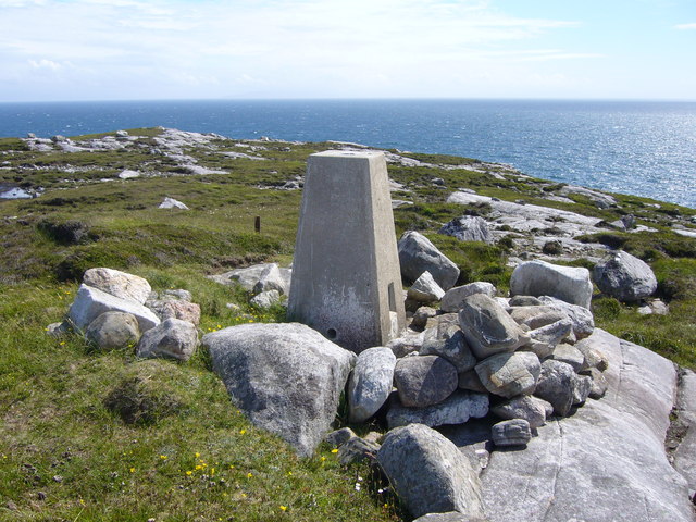
The island's rugged terrain is composed of steep cliffs, rocky outcrops, and sparse vegetation, making it an ideal nesting site for the seabirds. Access to the island is limited and can only be achieved by boat, as there are no landing facilities available.

Due to its remote location and protected status, Sgeir Caitriona offers a tranquil and undisturbed environment for wildlife enthusiasts and birdwatchers. Visitors can observe the birds from a distance, ensuring minimal disturbance to the fragile ecosystem.

In addition to its natural beauty, Sgeir Caitriona offers panoramic views of the surrounding sea and nearby islands. It is a popular spot for photographers and nature lovers seeking a unique and picturesque experience.

As with any nature reserve, visitors are encouraged to follow guidelines to preserve the delicate balance of the ecosystem and respect the island's protected status.

If you have any feedback on the listing, please let us know in the comments section below.

Sgeir Caitriona Images

Images are sourced within 2km of 57.777774/-6.8734389 or Grid Reference NG1086. Thanks to Geograph Open Source API. All images are credited.

Fish Farm Pier at Loch Huamabhat
Solitary White house Geocaching is a type of global treasure hunt of people looking for caches, or hidden stashes of objects. Geocaching may also be described as a series of hide-and-seek games, where hiders provide online clues for seekers. Seekers use global positioning system (GPS) devices to find hidden caches
Solitary White house
Geocaching is a type of global treasure hunt of people looking for caches, or hidden stashes of objects. Geocaching may also be described as a series of hide-and-seek games, where hiders provide online clues for seekers. Seekers use global positioning system (GPS) devices to find hidden caches
Fishing Station? It's not immediately obvious what the reason for the large raft and jetties is.
Fishing Station?
It's not immediately obvious what the reason for the large raft and jetties is.
Cnoc and Lochan Topography The Lewisian gneiss typically produces topography with knolls or rocks interspersed with hollows that are occupied by small lochs. In geography and geology this is described as Cnoc and lochan topography.
Cnoc and Lochan Topography
The Lewisian gneiss typically produces topography with knolls or rocks interspersed with hollows that are occupied by small lochs. In geography and geology this is described as Cnoc and lochan topography.
Loch Buaile Cairistiona Mhurchaidh This rather cumbersome name for a very small loch means something like 'loch of Christina Murdoch's cattle fold'.
Loch Buaile Cairistiona Mhurchaidh
This rather cumbersome name for a very small loch means something like 'loch of Christina Murdoch's cattle fold'.
Rudha Quidnish trig
Rudha Quidnish trig
Unnamed Lochan on Flodabay Point Should have put my boots on for this one! Very wet underfoot
Unnamed Lochan on Flodabay Point
Should have put my boots on for this one! Very wet underfoot
Gate in the fence on the Golden Road Leading to an enclosure on the rocky land near Quidnish/Cuidhtinis.
Gate in the fence on the Golden Road
Leading to an enclosure on the rocky land near Quidnish/Cuidhtinis.
Loch Huamnabhat Looking northwest from The Golden Road.
Loch Huamnabhat
Looking northwest from The Golden Road.
Fishery on Loch Huamnabhat One of many on the lochs of Harris.
Fishery on Loch Huamnabhat
One of many on the lochs of Harris.
Sheep grazing by Loch Huamnabhat With a fine lochside Rowan.
Sheep grazing by Loch Huamnabhat
With a fine lochside Rowan.
Fence on moorland near Cuidhtinis, Harris Looking towards Roineabhal.
Fence on moorland near Cuidhtinis, Harris
Looking towards Roineabhal.
Hay drying on lazy beds, Cuidhtinis, Harris Disused lazy beds can be seen on the hillside opposite.
Hay drying on lazy beds, Cuidhtinis, Harris
Disused lazy beds can be seen on the hillside opposite.
Still here... View down Loch Fhionnsabhaigh (Finsbay) with seal colony on long known haul out <a href="https://www.geograph.org.uk/photo/205871">NG0887 : Seals in Loch Fionnsabhagh</a>  This view taken slightly to south of John Allan's in July 2006.
Still here...
View down Loch Fhionnsabhaigh (Finsbay) with seal colony on long known haul out NG0887 : Seals in Loch Fionnsabhagh This view taken slightly to south of John Allan's in July 2006.
Roches Moutonnées This French phrase means something like 'sheep-shaped rocks' and there are any amount of them in eastern Harris. They are formed by ice flowing over them, and they have a smooth profile on the upstream side and a plucked, steeper profile downstream. These ones indicate that the direction of flow of the ice here was roughly from north-west to south-east.
Roches Moutonnées
This French phrase means something like 'sheep-shaped rocks' and there are any amount of them in eastern Harris. They are formed by ice flowing over them, and they have a smooth profile on the upstream side and a plucked, steeper profile downstream. These ones indicate that the direction of flow of the ice here was roughly from north-west to south-east.
Cnoc and Lochan with Roches Moutonnées The Lewisian gneiss in south-east Harris forms typical topography of riocky outcrops and small lochans or boggy patches - not ideal for walking! The French phrase Roches Moutonnées means something like 'sheep-shaped rocks' and there are any amount of them in eastern Harris. They are formed by ice flowing over them, and they have a smooth profile on the upstream side and a plucked, steeper profile downstream. These ones indicate that the direction of flow of the ice here was roughly from west to east.
Cnoc and Lochan with Roches Moutonnées
The Lewisian gneiss in south-east Harris forms typical topography of riocky outcrops and small lochans or boggy patches - not ideal for walking! The French phrase Roches Moutonnées means something like 'sheep-shaped rocks' and there are any amount of them in eastern Harris. They are formed by ice flowing over them, and they have a smooth profile on the upstream side and a plucked, steeper profile downstream. These ones indicate that the direction of flow of the ice here was roughly from west to east.
Lochan at Cuidhtinis (Quidnish) The road comes to an end just beside this small lochan. Note the different vegetation on the islet, which the sheep are unable to reach.
Lochan at Cuidhtinis (Quidnish)
The road comes to an end just beside this small lochan. Note the different vegetation on the islet, which the sheep are unable to reach.
Sruth Mòr at Cuidhtinis (Quidnish) The narrow sea-loch at Cuidtinis is a very sheltered arm of Loch Fionnsabhagh. 'Sruth'means a stream or tide, and mòr means 'big'. It seems curious that there should be a big tidal stream in a small landlocked inlet.
Sruth Mòr at Cuidhtinis (Quidnish)
The narrow sea-loch at Cuidtinis is a very sheltered arm of Loch Fionnsabhagh. 'Sruth'means a stream or tide, and mòr means 'big'. It seems curious that there should be a big tidal stream in a small landlocked inlet.
Show me another place!

Sgeir Caitriona is located at Grid Ref: NG1086 (Lat: 57.777774, Lng: -6.8734389)

Unitary Authority: Na h-Eileanan an Iar

Police Authority: Highlands and Islands

What 3 Words

///uplifting.enabling.slab. Near Leverburgh, Na h-Eileanan Siar

Related Wikis

Borsham

Borsham (Scottish Gaelic: Boirseam) is a village in the 'Bays' area of Harris in the Outer Hebrides, Scotland. Borsham is within the parish of Harris....

Lingarabay

Lingarabay (also Lingerabay or Lingerbay; Scottish Gaelic: Lingreabhagh) is a small coastal settlement on Harris, in the Outer Hebrides of Scotland. It...

Harris Superquarry

The Harris Super Quarry was a super quarry at Lingerbay, Harris, Scotland proposed by Redland Aggregates in 1991. The plan was to surface mine aggregate...

Stockinish Island

Stockinish Island (Scottish Gaelic: Eilean Stocainis) is an uninhabited island off Harris, in the Outer Hebrides. == Geography and geology == Stockinish...

Have you been to Sgeir Caitriona?

Leave your review of Sgeir Caitriona below (or comments, questions and feedback).