Eilean nan Stearnag
Island in Inverness-shire
Scotland
Eilean nan Stearnag

Eilean nan Stearnag is a small island located in the Inner Hebrides of Scotland, specifically in Inverness-shire. The island is situated off the western coast of Scotland, in the Atlantic Ocean. It is part of a group of islands known as the Small Isles, which also includes Eigg, Muck, and Rum.
Eilean nan Stearnag covers an area of approximately 0.4 square kilometers, making it a relatively small landmass. The island is characterized by its rugged and rocky terrain, with steep cliffs and a lack of vegetation. It is mainly composed of ancient volcanic rocks, which contribute to its unique geological features.
Due to its remote location and challenging terrain, Eilean nan Stearnag is uninhabited and has no permanent infrastructure. However, it is a popular destination for nature enthusiasts and bird watchers. The island is home to a variety of bird species, including puffins, guillemots, and razorbills, which nest on the cliffs during the breeding season.
Access to Eilean nan Stearnag is limited, with no regular ferry services or accommodation available on the island. Visitors interested in exploring the island can arrange private boat trips or join guided tours from nearby ports. It is important to note that the island is protected as a Site of Special Scientific Interest (SSSI), ensuring the preservation of its unique natural environment.
Overall, Eilean nan Stearnag offers a remote and untouched landscape, making it a fascinating destination for those seeking solitude and a chance to observe Scotland's diverse wildlife.
If you have any feedback on the listing, please let us know in the comments section below.
Eilean nan Stearnag Images
Images are sourced within 2km of 58.000184/-7.0325647 or Grid Reference NB0212. Thanks to Geograph Open Source API. All images are credited.


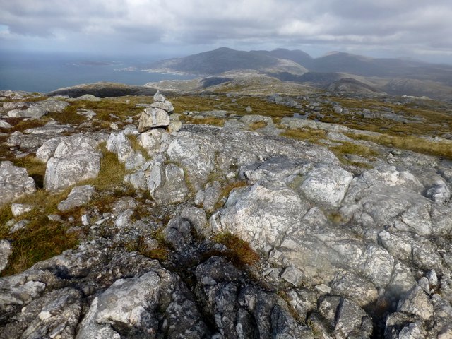
![Ceartaval [Ceartabhal] Second subMarilyn today in mixed weather with the magnificent seven in mixed weather.
Name: Ceartaval [Ceartabhal]
Hill number: 1593
Height: 556m / 1824ft
Area: 24B: Harris and Nearby Islands
Class: Hu,5H,sMa
Grid ref: NB 04262 12675
Summit feature: rock
Drop: 145m
Col: 411m NB049125](https://s0.geograph.org.uk/geophotos/03/69/52/3695208_0cce8fdf.jpg)
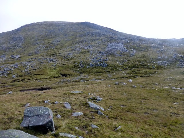
![View Towards Ceartabhal A lovely view towards Ceartaval [Ceartabhal] which captures all that is good about hill walking on the Isle of Harris.](https://s1.geograph.org.uk/geophotos/03/69/52/3695221_e1ae2c0b.jpg)

Eilean nan Stearnag is located at Grid Ref: NB0212 (Lat: 58.000184, Lng: -7.0325647)
Unitary Authority: Na h-Eileanan an Iar
Police Authority: Highlands and Islands
What 3 Words
///cyber.comet.lush. Near Tarbert, Na h-Eileanan Siar
Nearby Locations
Related Wikis

Tiorga Mor
Tiorga Mor (679 m) is a mountain in Harris, in the Outer Hebrides of Scotland. The most westerly peak of the high mountains of Harris, it is a very rugged...

Hushinish
Huisinish or Hushinish (Scottish Gaelic Hùisinis) is a remote place on the west coast of Harris in the Outer Hebrides of Scotland. It lies at the end of...

Amhuinnsuidhe
Amhuinnsuidhe (Scottish Gaelic: Abhainn Suidhe) is a settlement on Harris, in the Outer Hebrides, Scotland. The settlement is also within the parish of...

Chliostair Hydro-Electric Scheme
Chliostair Hydro-Electric Scheme is a small scheme promoted by the North of Scotland Hydro-Electric Board on Harris, Outer Hebrides. It consists of a single...
Nearby Amenities
Located within 500m of 58.000184,-7.0325647Have you been to Eilean nan Stearnag?
Leave your review of Eilean nan Stearnag below (or comments, questions and feedback).