Manuel Scud

Island in Cornwall

England

Manuel Scud

Bar Point at a low spring tide Looking across Crow Sound to the western end of St Martin’s, Tean, and St Helen’s.
Bar Point at a low spring tide Credit: David Lally

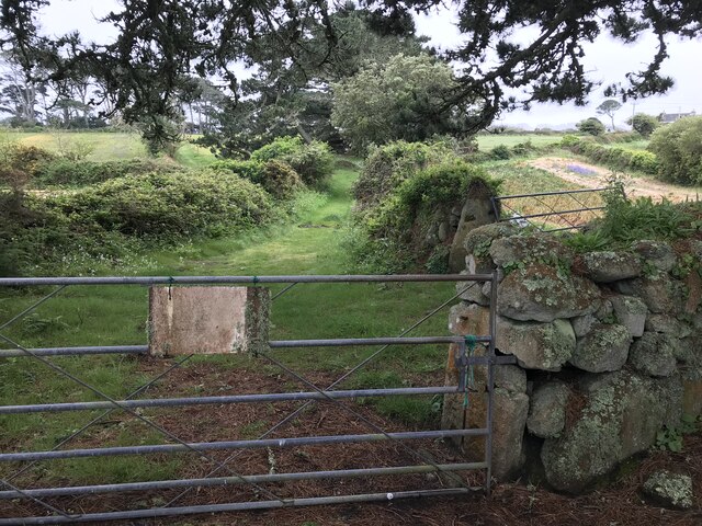
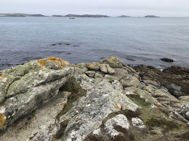
Manuel Scud is a small, uninhabited island located off the coast of Cornwall, England. Situated in the Celtic Sea, it is part of the Isles of Scilly archipelago, known for its picturesque landscapes and rich biodiversity. Manuel Scud is one of the smaller islands in the group, covering an area of approximately 0.2 hectares.

The island is predominantly rocky, with rugged cliffs that provide nesting sites for various seabirds, including puffins, gulls, and razorbills. Its rocky shores are also home to a diverse range of marine life, such as crabs, lobsters, and small fish.

Access to Manuel Scud is limited due to its remote location and lack of facilities. However, it is a popular destination for birdwatchers and nature enthusiasts who are keen to observe the island's unique wildlife. Visitors can reach the island by boat or kayak, but caution is advised due to the treacherous waters surrounding it.

The island's name, Manuel Scud, is said to have derived from the Cornish language, with "Manuel" meaning "island of stone" and "Scud" referring to the seabirds that inhabit the area. The name aptly describes the island's rocky terrain and the abundant birdlife that can be found there.

In summary, Manuel Scud is a small, uninhabited island off the coast of Cornwall, renowned for its rugged cliffs, diverse bird population, and thriving marine ecosystem. It offers a unique opportunity for nature lovers to immerse themselves in the beauty of the Isles of Scilly.

If you have any feedback on the listing, please let us know in the comments section below.

Manuel Scud Images

Images are sourced within 2km of 49.945981/-6.2827531 or Grid Reference SV9213. Thanks to Geograph Open Source API. All images are credited.

Bar Point at a low spring tide Looking across Crow Sound to the western end of St Martin’s, Tean, and St Helen’s.
Bar Point at a low spring tide
Looking across Crow Sound to the western end of St Martin’s, Tean, and St Helen’s.
Looking east from Bar Point At a low spring tide.
Looking east from Bar Point
At a low spring tide.
Entrance to the Innisidgen chambered cairn Scheduled Monument including both burial cairn and other features:

Two entrance graves, a prehistoric field system, and Civil War fieldworks and blockhouse on Innisidgen Hill and Helvear Down, St Mary's

List Entry Number:1013271 <span class="nowrap"><a title="https://historicengland.org.uk/listing/the-list/list-entry/1013271?section=official-list-entry" rel="nofollow ugc noopener" href="https://historicengland.org.uk/listing/the-list/list-entry/1013271?section=official-list-entry">Link</a><img style="margin-left:2px;" alt="External link" title="External link - shift click to open in new window" src="https://s1.geograph.org.uk/img/external.png" width="10" height="10"/></span>
Entrance to the Innisidgen chambered cairn
Scheduled Monument including both burial cairn and other features: Two entrance graves, a prehistoric field system, and Civil War fieldworks and blockhouse on Innisidgen Hill and Helvear Down, St Mary's List Entry Number:1013271 LinkExternal link
Rope swing near Innisidgen Hanging from a very high branch of a Monterey Pine.
Rope swing near Innisidgen
Hanging from a very high branch of a Monterey Pine.
Gate with faded sign Possibly an old PRIVATE sign? According to the OS  the track ahead is a right of way..
Gate with faded sign
Possibly an old PRIVATE sign? According to the OS the track ahead is a right of way..
Rocks near Pellew's Redoubt A reprograph of my own first for the square <a title="https://www.geograph.org.uk/photo/815561" href="https://www.geograph.org.uk/photo/815561">Link</a> if only because there’s nothing much else in it! Should get me a T point too!
Rocks near Pellew's Redoubt
A reprograph of my own first for the square Link if only because there’s nothing much else in it! Should get me a T point too!
A track on eastern St Martin’s The track runs uphill from the eastern end of Higher Town Bay to the Chapel Down and the Daymark.
A track on eastern St Martin’s
The track runs uphill from the eastern end of Higher Town Bay to the Chapel Down and the Daymark.
St Mary's Harbour Pilot Boat in Crow Sound
Crow Sound, Toll's Island A small fishing boat navigates Crow Sound on the eastern side of St Mary's in the Isles of Scilly.  Toll's Island is one of the tidal islands off the Isles of Scilly.  It is located 100 metres east of the coast of St Mary's at Pelistry.  Toll’s Island is linked to St Mary's by a sandy isthmus which is covered at high tide.
Crow Sound, Toll's Island
A small fishing boat navigates Crow Sound on the eastern side of St Mary's in the Isles of Scilly. Toll's Island is one of the tidal islands off the Isles of Scilly. It is located 100 metres east of the coast of St Mary's at Pelistry. Toll’s Island is linked to St Mary's by a sandy isthmus which is covered at high tide.
Isles of Scilly, Eastern Isles from Crow Sound The large island in the background is St Martin's.
Isles of Scilly, Eastern Isles from Crow Sound
The large island in the background is St Martin's.
Hats South Cardinal Marker, Crow Sound A cardinal mark is a sea mark (a buoy or other floating or fixed structure) used in maritime pilotage to indicate the position of a hazard and the direction of safe water. The direction of its two conical top marks indicates the safest side to pass. In this case, both cones are pointing down which indicates that shipping should pass on the south side of the buoy (to avoid the Hats shallows and an uncovering boiler structure from a wreck in the sound. <span class="nowrap"><a title="https://en.wikipedia.org/wiki/Cardinal_mark" rel="nofollow ugc noopener" href="https://en.wikipedia.org/wiki/Cardinal_mark">Link</a><img style="margin-left:2px;" alt="External link" title="External link - shift click to open in new window" src="https://s1.geograph.org.uk/img/external.png" width="10" height="10"/></span>  (Cardinal Mark, Wikipedia).
Hats South Cardinal Marker, Crow Sound
A cardinal mark is a sea mark (a buoy or other floating or fixed structure) used in maritime pilotage to indicate the position of a hazard and the direction of safe water. The direction of its two conical top marks indicates the safest side to pass. In this case, both cones are pointing down which indicates that shipping should pass on the south side of the buoy (to avoid the Hats shallows and an uncovering boiler structure from a wreck in the sound. LinkExternal link (Cardinal Mark, Wikipedia).
Isles of Scilly. Little Ganinick One of the Eastern Isles, a group of twelve small uninhabited islands within the Isles of Scilly Area of Outstanding Natural Beauty. Part of the larger island of Great Ganinick (with more vegetation) can be seen behind (and slightly to the right of) Little Ganinick.
Isles of Scilly. Little Ganinick
One of the Eastern Isles, a group of twelve small uninhabited islands within the Isles of Scilly Area of Outstanding Natural Beauty. Part of the larger island of Great Ganinick (with more vegetation) can be seen behind (and slightly to the right of) Little Ganinick.
Isles of Scilly, Great Arthur Great, Middle and Little Arthur are three of the Eastern Isles, a group of twelve small uninhabited islands within the Isles of Scilly Area of Outstanding Natural Beauty. Great Arthur, as its name suggests, is the largest of the three.
Isles of Scilly, Great Arthur
Great, Middle and Little Arthur are three of the Eastern Isles, a group of twelve small uninhabited islands within the Isles of Scilly Area of Outstanding Natural Beauty. Great Arthur, as its name suggests, is the largest of the three.
Isles of Scilly, Rocky Ledge between Middle and Great Arthur Great, Middle and Little Arthur are three of the Eastern Isles, a group of twelve small uninhabited islands within the Isles of Scilly Area of Outstanding Natural Beauty. Great Arthur, as its name suggests, is the largest of the three.
Isles of Scilly, Rocky Ledge between Middle and Great Arthur
Great, Middle and Little Arthur are three of the Eastern Isles, a group of twelve small uninhabited islands within the Isles of Scilly Area of Outstanding Natural Beauty. Great Arthur, as its name suggests, is the largest of the three.
Isles of Scilly, Middle Arthur Great, Middle and Little Arthur are three of the Eastern Isles, a group of twelve small uninhabited islands within the Isles of Scilly Area of Outstanding Natural Beauty. Great Arthur, as its name suggests, is the largest of the three.
Isles of Scilly, Middle Arthur
Great, Middle and Little Arthur are three of the Eastern Isles, a group of twelve small uninhabited islands within the Isles of Scilly Area of Outstanding Natural Beauty. Great Arthur, as its name suggests, is the largest of the three.
Middle Arthur, Arthur Quay Great, Middle and Little Arthur are three of the Eastern Isles, a group of twelve small uninhabited islands within the Isles of Scilly Area of Outstanding Natural Beauty. Great Arthur, as its name suggests, is the largest of the three.

The three rocky islands are joined by two beaches forming a crescent around Arthur Porth.
Middle Arthur, Arthur Quay
Great, Middle and Little Arthur are three of the Eastern Isles, a group of twelve small uninhabited islands within the Isles of Scilly Area of Outstanding Natural Beauty. Great Arthur, as its name suggests, is the largest of the three. The three rocky islands are joined by two beaches forming a crescent around Arthur Porth.
Rocky Shore, Little Ganilly Little Ganilly (Cornish: Goonhyli Bian, little salt water down) lies just to the north of Little Arthur.
Rocky Shore, Little Ganilly
Little Ganilly (Cornish: Goonhyli Bian, little salt water down) lies just to the north of Little Arthur.
Great Ganilly, West Porth Great Ganilly (Cornish: Goonhyli Meur) is the largest of the Eastern Isles and consists of two hills joined together by a low sandy neck.
Great Ganilly, West Porth
Great Ganilly (Cornish: Goonhyli Meur) is the largest of the Eastern Isles and consists of two hills joined together by a low sandy neck.
Show me another place!

Manuel Scud is located at Grid Ref: SV9213 (Lat: 49.945981, Lng: -6.2827531)

Division: Isles of Scilly

Unitary Authority: Isles of Scilly

Police Authority: Devon and Cornwall

What 3 Words

///inhabited.promotion.novelists. Near St Martin's, Isles of Scilly

Nearby Locations

Manuel Scud

Related Wikis

Wheel Wreck

The Wheel Wreck is the remains of a shipwreck lying in Crow sound off Little Ganinick in the Isles of Scilly. The wreck site consists of a discrete mound...

Innisidgen

Innisidgen (Cornish: Enys Ojyon, meaning Ox Island) is the site of two Bronze Age entrance graves on the island of St Mary's in the Isles of Scilly. The...

St Martin's Methodist Church, Isles of Scilly

The Methodist Church, St Martin's, Isles of Scilly is a Grade II listed chapel in St Martin's, Isles of Scilly. == History == Bible Christians arrived...

Higher Town, Isles of Scilly

Higher Town (Cornish: Trewartha) is the easternmost and largest settlement on the island of St Martin's in the Isles of Scilly, England. It is situated...

Nearby Amenities

Located within 500m of 49.945981,-6.2827531
Natural: peak
Lat/Long: 49.9456211/-6.2770731
The data included in this document is from www.openstreetmap.org. The data is made available under ODbL.

Have you been to Manuel Scud?

Leave your review of Manuel Scud below (or comments, questions and feedback).