Aird nam Feadag

Island in Inverness-shire

Scotland

Aird nam Feadag

Ruined buildings at Buaile-mhòr
Ruined buildings at Buaile-mhòr Credit: Toby Speight

Aird nam Feadag is a small island located off the coast of Inverness-shire, in the Scottish Highlands. It is situated in the Inner Hebrides, specifically in the Sound of Sleat. The island covers an area of approximately 1 square kilometer and is largely uninhabited.

Aird nam Feadag is known for its rugged and picturesque landscape, characterized by steep cliffs, rocky shores, and rolling hills. The island is also home to a variety of wildlife, including seabirds, seals, and occasionally otters. Its remote location and natural beauty make it a popular destination for nature enthusiasts and birdwatchers.

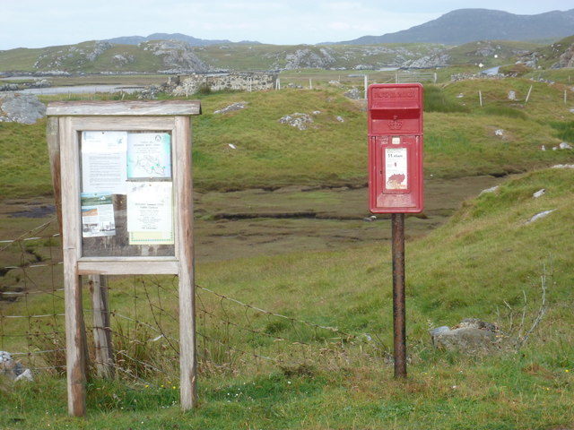
Access to Aird nam Feadag is primarily by boat, either private or through organized tours. There are no permanent facilities or accommodations on the island, making it a true wilderness experience for visitors. The lack of human habitation also contributes to the pristine and unspoiled nature of the island.

The island's name, Aird nam Feadag, translates to "Point of the Plovers" in English, referencing the abundance of plovers that can be found in the area. The surrounding waters also offer excellent opportunities for fishing and boating, further adding to the appeal of the island.

In conclusion, Aird nam Feadag is a remote and untouched island off the coast of Inverness-shire, offering visitors a unique and serene natural experience. With its stunning landscapes and abundant wildlife, it is a haven for those seeking tranquility and a connection with nature.

If you have any feedback on the listing, please let us know in the comments section below.

Aird nam Feadag Images

Images are sourced within 2km of 57.501504/-7.2254296 or Grid Reference NF8757. Thanks to Geograph Open Source API. All images are credited.
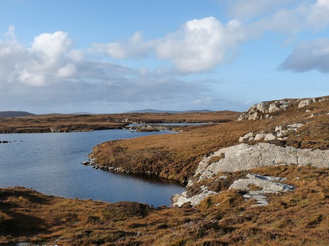
Ruined buildings at Buaile-mhòr
Rubh' an t-Sagairt
Rubh' an t-Sagairt
Eilean na Hoe
Eilean na Hoe
Eilean Buidhe
Eilean Buidhe
Gearraidh Dubh Looking over the shore near Gearraidh Dubh towards Eabhal.
Gearraidh Dubh
Looking over the shore near Gearraidh Dubh towards Eabhal.
Loch na Faoileag on Grimsay One of many small islets on Loch na Faoileag on the Isle of Grimsay
Loch na Faoileag on Grimsay
One of many small islets on Loch na Faoileag on the Isle of Grimsay
Loch na Faoileag Shoreline A view along the shoreline to north west finger on Loch na Faoileag (Isle of Grimsay) .Taken on the opposite bank from the roadside.
Loch na Faoileag Shoreline
A view along the shoreline to north west finger on Loch na Faoileag (Isle of Grimsay) .Taken on the opposite bank from the roadside.
Loch na Faoileag Cairn A small cairn situated at the south-eastern end of Loch na Faoileag.
Loch na Faoileag Cairn
A small cairn situated at the south-eastern end of Loch na Faoileag.
Near Gearraidh Dubh
Near Gearraidh Dubh
Bagh Sgotbheinn Not all Hebridean buildings fall into disrepair. I note that Dave Fergusson's 2007 photograph includes this small building, but now, twelve years later it has a new roof and is looking well cared for.
Bagh Sgotbheinn
Not all Hebridean buildings fall into disrepair. I note that Dave Fergusson's 2007 photograph includes this small building, but now, twelve years later it has a new roof and is looking well cared for.
Old harbour, Grimsay A crofthouse sitting on a reclaimed piece of land at Baymore (Bagh mor) which was the main harbour on the island before the Kallin (Ceallan) development.  The harbour is littered with lots of old creels and other flotsam and there are many old stone piers.
Old harbour, Grimsay
A crofthouse sitting on a reclaimed piece of land at Baymore (Bagh mor) which was the main harbour on the island before the Kallin (Ceallan) development. The harbour is littered with lots of old creels and other flotsam and there are many old stone piers.
Thatch at Cladach Chairinis
The summit region of Grimsay Grimsay is a low island between North Uist and Benbecula. It is difficult to be certain of its highest point, but this eminence, 25m or so above Mean Sea Level, is a good contender.
The summit region of Grimsay
Grimsay is a low island between North Uist and Benbecula. It is difficult to be certain of its highest point, but this eminence, 25m or so above Mean Sea Level, is a good contender.
Isle of Ronay View towards North Uist
Isle of Ronay
View towards North Uist
Sandy inlet on the coast of Grimsay One of a maze of inlets and channels around Grimsay. This view is interesting as there are remains of old field walls [possibly iron age/centre picture] visible in the sand, indicating a lower sea level at some time. Cloud capped Eabhal rises in the distance.
Sandy inlet on the coast of Grimsay
One of a maze of inlets and channels around Grimsay. This view is interesting as there are remains of old field walls [possibly iron age/centre picture] visible in the sand, indicating a lower sea level at some time. Cloud capped Eabhal rises in the distance.
Baymore: postbox № HS6 15 One of four postboxes on the island of Grimsay. Apart from the one on the main road close to the post office, they are emptied at 11:45am on weekdays and at 9:30am on Saturdays.
Baymore: postbox № HS6 15
One of four postboxes on the island of Grimsay. Apart from the one on the main road close to the post office, they are emptied at 11:45am on weekdays and at 9:30am on Saturdays.
Gearadu: postbox № HS6 34 One of four postboxes on the island of Grimsay. Apart from the one on the main road close to the post office, they are emptied at 11:45am on weekdays and at 9:30am on Saturdays.
Gearadu: postbox № HS6 34
One of four postboxes on the island of Grimsay. Apart from the one on the main road close to the post office, they are emptied at 11:45am on weekdays and at 9:30am on Saturdays.
Loch nan Gealag
Loch nan Gealag
Show me another place!

Aird nam Feadag is located at Grid Ref: NF8757 (Lat: 57.501504, Lng: -7.2254296)

Unitary Authority: Na h-Eileanan an Iar

Police Authority: Highlands and Islands

What 3 Words

///joys.revival.definite. Near Balivanich, Na h-Eileanan Siar

Related Wikis

Fraoch-Eilean

Fraoch-eilean is a small island with an uncertain population north of Benbecula in the Outer Hebrides of Scotland. It is about 55 hectares (140 acres...

Grimsay

Grimsay (Scottish Gaelic: Griomasaigh) is a tidal island in the Outer Hebrides of Scotland. == Geography == Grimsay is the largest of the low-lying stepping...

Baile Glas

Baile Glas or Ballaglasa (Scottish Gaelic: Am Baile Glas) is a settlement on Grimsay in the Outer Hebrides, Scotland. Ballaglasa is within the parish of...

Ronay

Ronay (Scottish Gaelic: Rònaigh) is an island in the Outer Hebrides of Scotland, which lies a short distance off the east coast of Grimsay. == Geography... ==

Nearby Amenities

Located within 500m of 57.501504,-7.2254296
Created By: dmgroom_coastlines
Lat/Long: 57.50256/-7.22328
Created By: dmgroom_coastlines
Lat/Long: 57.50231/-7.22353
Bàgh nam Feadag
Natural: bay
Lat/Long: 57.4987861/-7.2251845
The data included in this document is from www.openstreetmap.org. The data is made available under ODbL.

Have you been to Aird nam Feadag?

Leave your review of Aird nam Feadag below (or comments, questions and feedback).