Eilean Mhic Dhonuill Bhuidhe

Island in Inverness-shire

Scotland

Eilean Mhic Dhonuill Bhuidhe

Pony and ruin, Carinish
Pony and ruin, Carinish Credit: Hugh Venables

Eilean Mhic Dhonuill Bhuidhe is a small island located in Inverness-shire, Scotland. The island is situated in the picturesque Loch Shiel, a freshwater lake surrounded by stunning mountainous landscapes.

Eilean Mhic Dhonuill Bhuidhe, also known as the Island of MacDonald of the Yellow Brown, is rich in history and has been inhabited for centuries. The island is named after the MacDonald clan, who were once prominent in the area.

The island itself is relatively small, measuring approximately 1.5 acres in size. It is covered in lush green vegetation and is home to a variety of wildlife, including birds, deer, and otters. The surrounding waters of Loch Shiel are also teeming with fish, making it a popular spot for anglers.

Eilean Mhic Dhonuill Bhuidhe is accessible by boat and provides a tranquil retreat for visitors. The island offers breathtaking views of the surrounding landscape, with the mountains of the Scottish Highlands serving as a dramatic backdrop.

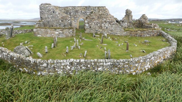
Visitors to the island can explore its natural beauty by hiking along its trails or simply enjoy a picnic on its shores. The island is also home to the ruins of a medieval castle, adding to its historical charm.

Overall, Eilean Mhic Dhonuill Bhuidhe is a hidden gem in Inverness-shire, offering a serene escape for nature lovers and history enthusiasts alike.

If you have any feedback on the listing, please let us know in the comments section below.

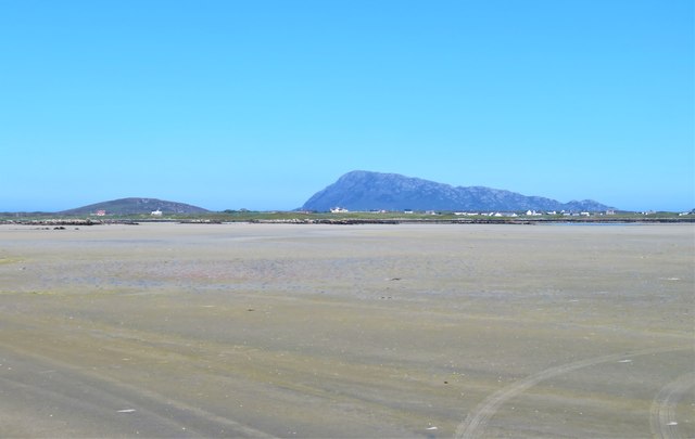
Eilean Mhic Dhonuill Bhuidhe Images

Images are sourced within 2km of 57.514882/-7.3346714 or Grid Reference NF8059. Thanks to Geograph Open Source API. All images are credited.

Pony and ruin, Carinish
End of the road at Àird Mhòr
House at Carinish
House at Carinish
Marshy area at Carinish Seemingly a naturally infilled loch.
Marshy area at Carinish
Seemingly a naturally infilled loch.
Outside Talla Chairinis, North Uist Outside a community hall
Outside Talla Chairinis, North Uist
Outside a community hall
Blar Chairinis Site of battle in 1601.
Blar Chairinis
Site of battle in 1601.
Stone barn at Carinish
The ruins of Trinity Temple (Teampull na Trianaid) According to the plaque "Medieval monastery and college of European significance, founded by Beathag, daughter of Somhairle (Somerled).  Enlarged about 1350 to 1390 by Amie Mic Ruarie, first wife of John, Lord of the Isles.  Reconstructed in the 16th century.  Destroyed after the reformation.  Later restored in the 19th century by Dotair Ban."
The ruins of Trinity Temple (Teampull na Trianaid)
According to the plaque "Medieval monastery and college of European significance, founded by Beathag, daughter of Somhairle (Somerled). Enlarged about 1350 to 1390 by Amie Mic Ruarie, first wife of John, Lord of the Isles. Reconstructed in the 16th century. Destroyed after the reformation. Later restored in the 19th century by Dotair Ban."
Field and houses at Carinish And also the site of Feith na Fala (The ditch of blood) - a battle waged in 1601 between the MacLeods and the MacDonalds.
Field and houses at Carinish
And also the site of Feith na Fala (The ditch of blood) - a battle waged in 1601 between the MacLeods and the MacDonalds.
Bagh a’ Ghriasaiche
Bagh a’ Ghriasaiche
Fèithe na Fala - The ditch of blood
View from Temple View Hotel Teampull na Trionaid is a ruined 13th-century church and seminary at Carinish, North Uist, Scotland. Amie mac Ruari is said to have rebuilt the church in the 14th century after her divorce from John of Islay, Lord of the Isles. The ruins are protected as a scheduled monument.
View from Temple View Hotel
Teampull na Trionaid is a ruined 13th-century church and seminary at Carinish, North Uist, Scotland. Amie mac Ruari is said to have rebuilt the church in the 14th century after her divorce from John of Islay, Lord of the Isles. The ruins are protected as a scheduled monument.
Closer to the temple The ruins of Trinity Temple (Teampull na Trianaid)
Closer to the temple
The ruins of Trinity Temple (Teampull na Trianaid)
Free Church, Cairinis Current OS maps show this as a church, but older versions show it as a pub, which was its original purpose. Enough said.
Free Church, Cairinis
Current OS maps show this as a church, but older versions show it as a pub, which was its original purpose. Enough said.
Teampull Na Trionaid A 14th century church with earlier origins. <span class="nowrap"><a title="https://canmore.org.uk/site/10265/north-uist-carinish-teampull-na-trionaid" rel="nofollow ugc noopener" href="https://canmore.org.uk/site/10265/north-uist-carinish-teampull-na-trionaid">Link</a><img style="margin-left:2px;" alt="External link" title="External link - shift click to open in new window" src="https://s1.geograph.org.uk/img/external.png" width="10" height="10"/></span>
Teampull Na Trionaid
A 14th century church with earlier origins. LinkExternal link
Teampull Na Trionaid View from the south. <span class="nowrap"><a title="https://canmore.org.uk/site/10265/north-uist-carinish-teampull-na-trionaid" rel="nofollow ugc noopener" href="https://canmore.org.uk/site/10265/north-uist-carinish-teampull-na-trionaid">Link</a><img style="margin-left:2px;" alt="External link" title="External link - shift click to open in new window" src="https://s1.geograph.org.uk/img/external.png" width="10" height="10"/></span>
Teampull Na Trionaid
View from the south. LinkExternal link
A sandy island surrounded by sand This is the part of the extensive area of tidal sand on the east side of Baile Sear island. The sand must be firm due to the number of vehicle tyre tracks across it. Looking due east towards the profile of Eabhal.
A sandy island surrounded by sand
This is the part of the extensive area of tidal sand on the east side of Baile Sear island. The sand must be firm due to the number of vehicle tyre tracks across it. Looking due east towards the profile of Eabhal.
Vehicle graveyard Baile Sear Vehicles are rather like dwellings on the Western Isles. When no longer wanted, they are simply left to rot out in the elements.
Vehicle graveyard Baile Sear
Vehicles are rather like dwellings on the Western Isles. When no longer wanted, they are simply left to rot out in the elements.
Show me another place!

Eilean Mhic Dhonuill Bhuidhe is located at Grid Ref: NF8059 (Lat: 57.514882, Lng: -7.3346714)

Unitary Authority: Na h-Eileanan an Iar

Police Authority: Highlands and Islands

What 3 Words

///purchaser.craftsman.smallest. Near Balivanich, Na h-Eileanan Siar

Related Wikis

Bail' Iochdrach

Bail' Iochdrach or Baliochrach (Scottish Gaelic: Am Baile Ìochdrach) is a village on Benbecula in the Outer Hebrides, Scotland. Baliochrach is within the...

Teampull na Trionaid

Teampull na Trionaid ("trinity church") is a ruined 13th-century Augustinian nunnery at Carinish, on North Uist, in the Outer Hebrides of Scotland. �...

Battle of Carinish

The Battle of Carinish was a Scottish clan battle fought in North Uist in 1601. It was part of a year of feuding between Clan MacLeod of Dunvegan and the...

Carinish

Carinish (Scottish Gaelic: Càirinis), is a hamlet on North Uist, in the Outer Hebrides, Scotland. It is in the south of the island, about two miles (three...

Have you been to Eilean Mhic Dhonuill Bhuidhe?

Leave your review of Eilean Mhic Dhonuill Bhuidhe below (or comments, questions and feedback).