The Hambleton Hills

Range Of Mountains, Range Of Hills in Yorkshire Hambleton

England

The Hambleton Hills

Public Footpath leading South from Boltby
Public Footpath leading South from Boltby Credit: Chris Heaton

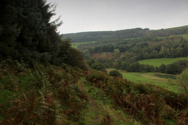
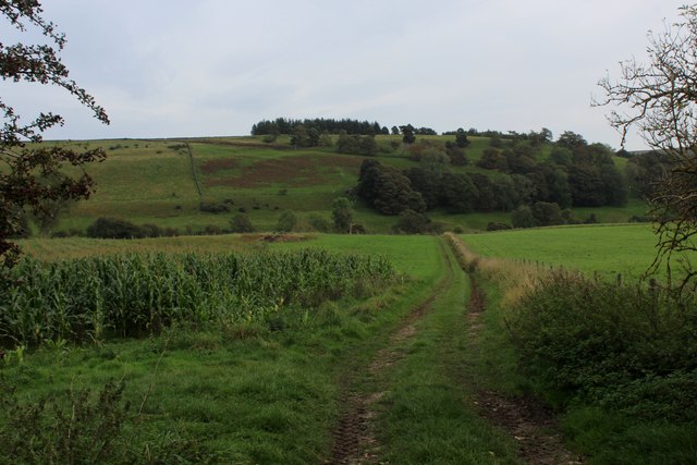
The Hambleton Hills, located in the county of Yorkshire in northern England, is a range of hills that stretches across an area of approximately 80 square miles. Situated between the Vale of York and the North York Moors National Park, this picturesque landscape offers breathtaking views and is a popular destination for outdoor enthusiasts and nature lovers.

The Hambleton Hills are characterized by their rolling, heather-covered slopes and deep valleys, which were carved by glaciers during the last Ice Age. The highest point in the range is the summit of Black Hambleton, standing at an elevation of 1,329 feet (405 meters) above sea level. From this vantage point, visitors can enjoy panoramic vistas of the surrounding countryside, including the Vale of Mowbray to the west and the North York Moors to the east.

The hills are home to a rich variety of flora and fauna, including heather, gorse, and oak woodlands. The area also supports a diverse range of wildlife, including red grouse, curlews, and brown hares. In addition, the Hambleton Hills are known for their archaeological significance, with ancient burial mounds and stone circles dotting the landscape.

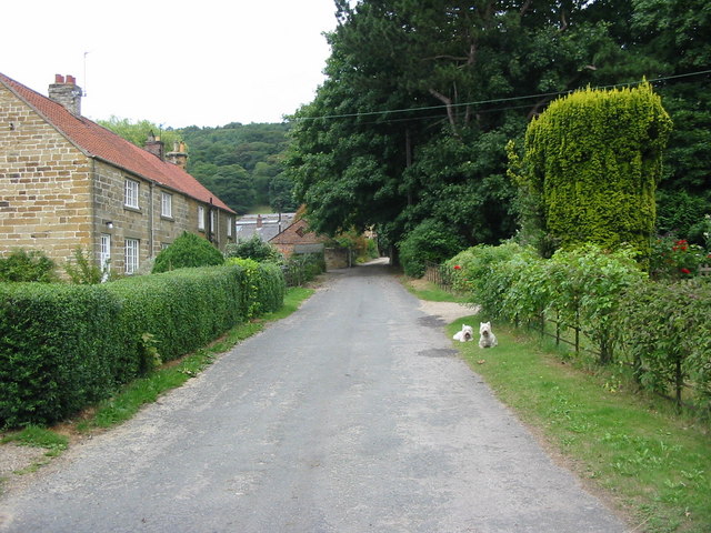
The region is crisscrossed by a network of footpaths and bridleways, making it a paradise for hikers, cyclists, and horse riders. There are also several charming villages and market towns nestled in the foothills, offering visitors the opportunity to explore the local history and culture.

Overall, the Hambleton Hills in Yorkshire offer a tranquil and idyllic escape, providing a perfect blend of natural beauty, recreational activities, and historical significance.

If you have any feedback on the listing, please let us know in the comments section below.

The Hambleton Hills Images

Images are sourced within 2km of 54.280178/-1.2219272 or Grid Reference SE5087. Thanks to Geograph Open Source API. All images are credited.

Public Footpath leading South from Boltby
Footpath leading down towards Lunshaw Beck The path from Boltby descends to cross Lunshaw Beck, before climbing steeply up the North York Moors escarpment to High Paradise
Footpath leading down towards Lunshaw Beck
The path from Boltby descends to cross Lunshaw Beck, before climbing steeply up the North York Moors escarpment to High Paradise
Footpath heading South towards Boltby
Track in Boltby Forest
Tree Felling Aftermath in Boltby Forest Scene of desolation after the chainsaws have vacated this area of Boltby Forest
Tree Felling Aftermath in Boltby Forest
Scene of desolation after the chainsaws have vacated this area of Boltby Forest
Track heading down to Gurtof Beck
North Woods view A section of Boltby Forest near its eastern edge. Here some of the steep slopes have been clear felled between mature conifers to either side. Somewhere beyond the upper lines of trees lurks High Paradise Farm and cafe.
North Woods view
A section of Boltby Forest near its eastern edge. Here some of the steep slopes have been clear felled between mature conifers to either side. Somewhere beyond the upper lines of trees lurks High Paradise Farm and cafe.
Country lanes Beautiful countryside just to the East of Boltby. The road in view takes you up Sneck Yat Bank.
Country lanes
Beautiful countryside just to the East of Boltby. The road in view takes you up Sneck Yat Bank.
The village of Boltby Boltby is a village and civil parish in the Hambleton district of North Yorkshire, England. It is on the edge of the North York Moors National Park, and about six miles north-east of Thirsk. According to the 2001 census it had a population of 149.
The village of Boltby
Boltby is a village and civil parish in the Hambleton district of North Yorkshire, England. It is on the edge of the North York Moors National Park, and about six miles north-east of Thirsk. According to the 2001 census it had a population of 149.
Across the fields to Boltby The rolling green hills around Boltby.
Across the fields to Boltby
The rolling green hills around Boltby.
Boltby, Holy Trinity Church This Church is in the western quarter of the O/S grid it occupies, to the north of centre.
Boltby, Holy Trinity Church
This Church is in the western quarter of the O/S grid it occupies, to the north of centre.
Construction Work, Lunshaw Reservoir These guys must be on time and a half for Saturday morning working.
Construction Work, Lunshaw Reservoir
These guys must be on time and a half for Saturday morning working.
Stile, Footpath to Low Paradise Farm
Boltby Village Hall
Boltby Village Hall
Pheasant Rearing Pens, North of Boltby
Private Road to Lunshaw House According to Get-a Map 1:25000 at the time of submission the Public Footpath extended up the road for another 400m or so before going into the field. The signs contradicts that. I wonder what the Definitive Map says?
Private Road to Lunshaw House
According to Get-a Map 1:25000 at the time of submission the Public Footpath extended up the road for another 400m or so before going into the field. The signs contradicts that. I wonder what the Definitive Map says?
Pasture Above Lunshaw Beck
Show me another place!

The Hambleton Hills is located at Grid Ref: SE5087 (Lat: 54.280178, Lng: -1.2219272)

Division: North Riding

Administrative County: North Yorkshire

District: Hambleton

Police Authority: North Yorkshire

What 3 Words

///remarked.ulterior.rides. Near Thirsk, North Yorkshire

Related Wikis

Boltby

Boltby is a village and civil parish in the Hambleton District of North Yorkshire, England. It is on the edge of the North York Moors National Park at...

Holy Trinity Church, Boltby

Holy Trinity Church, Boltby is a parish church in the Church of England: 81  in Boltby. == History == The first chapel was founded in 1409 and was rebuilt...

Kirby Knowle

Kirby Knowle is a village and civil parish in Hambleton District of North Yorkshire, England, on the border of the North Yorkshire Moors and near Upsall...

Thirlby

Thirlby is a village and civil parish in Hambleton district of North Yorkshire, England. With a population of about 120 in 2003, measured at 134 at the...

Cold Kirby

Cold Kirby is a village and civil parish in the Ryedale district of North Yorkshire, England. The population at the 2011 census (including Angram Grange...

Hawnby

Hawnby is a small crossroads village and civil parish in Ryedale in the North York Moors National Park, North Yorkshire, England. The village is about...

Gormire Lake

Gormire Lake is a natural lowland lake that lies at the foot of Whitestone Cliff, a western escarpment of the Hambleton Hills in the North York Moors National...

Mount St. John Preceptory

Mount St. John Preceptory was a preceptory of the Knights Hospitallers near Felixkirk in North Yorkshire, England. == History == A preceptory to the honour...

Nearby Amenities

Located within 500m of 54.280178,-1.2219272
Direction North: Osmotherley
Direction South: Sutton Bank
Guide Type: destination
Guidepost Type: route_marker;PROW
Information: guidepost
Tourism: information
Lat/Long: 54.2812327/-1.221996
Barrier: stile
Step Count: 1
Stile: stepover
Lat/Long: 54.2806806/-1.2217786
Information: guidepost
Tourism: information
Lat/Long: 54.2806983/-1.2217527
Passing Place
Lat/Long: 54.2833433/-1.2175584
Information: route_marker
Tourism: information
Lat/Long: 54.280669/-1.2218422
Information: route_marker
Tourism: information
Lat/Long: 54.2807506/-1.2218174
Information: guidepost
Tourism: information
Lat/Long: 54.2822577/-1.2187585
The data included in this document is from www.openstreetmap.org. The data is made available under ODbL.

Have you been to The Hambleton Hills?

Leave your review of The Hambleton Hills below (or comments, questions and feedback).