Aygill Pike

Range Of Mountains, Range Of Hills in Yorkshire Harrogate

England

Aygill Pike

Looking towards the Flaystones Looking north east across moorland to a large area of scattered gritstone rocks, boulders and outcrops known as the Flaystones.
Looking towards the Flaystones Credit: Chris Heaton

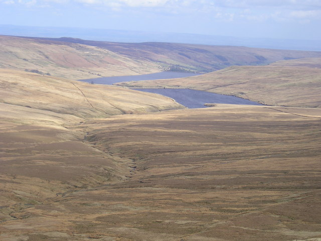
Aygill Pike is a prominent feature located in the Yorkshire Dales National Park in northern England. It forms part of the larger range of mountains and hills known as the Yorkshire Dales. Situated in the county of Yorkshire, Aygill Pike offers stunning views and is a popular destination for hikers and nature enthusiasts.

Standing at an elevation of 720 meters (2,362 feet), Aygill Pike is a limestone hill that boasts a distinct shape and commanding presence. Its slopes are covered in lush green vegetation, providing a picturesque backdrop for the surrounding area. The hill is part of a larger ridge that runs parallel to the valley of Swaledale, offering panoramic vistas of the rolling countryside.

The summit of Aygill Pike is relatively flat, making it an ideal spot for picnics or simply taking in the breathtaking scenery. On a clear day, visitors can enjoy unobstructed views of the surrounding Yorkshire Dales, including other notable hills such as Great Shunner Fell and Rogan's Seat.

The area surrounding Aygill Pike is rich in wildlife and offers a diverse range of flora and fauna. It is home to various species of birds, such as red grouse and peregrine falcons, as well as a variety of wildflowers and plants. The hill is also crisscrossed by several footpaths and trails, making it accessible for both experienced hikers and casual walkers.

Overall, Aygill Pike is a natural gem within the Yorkshire Dales, offering visitors a chance to immerse themselves in the beauty of the English countryside while enjoying outdoor activities and stunning views.

If you have any feedback on the listing, please let us know in the comments section below.

Aygill Pike Images

Images are sourced within 2km of 54.160041/-1.9258147 or Grid Reference SE0473. Thanks to Geograph Open Source API. All images are credited.

Looking towards the Flaystones Looking north east across moorland to a large area of scattered gritstone rocks, boulders and outcrops known as the Flaystones.
Looking towards the Flaystones
Looking north east across moorland to a large area of scattered gritstone rocks, boulders and outcrops known as the Flaystones.
Shooting Hut on Riggs Moor - Frontal View Very remote and isolated shooting hut, on the extensive moors east of Great Whernside
Shooting Hut on Riggs Moor - Frontal View
Very remote and isolated shooting hut, on the extensive moors east of Great Whernside
Shooting Hut on Riggs Moor - Rear View Very remote and isolated shooting hut to the east of Great Whernside
Shooting Hut on Riggs Moor - Rear View
Very remote and isolated shooting hut to the east of Great Whernside
Access to Grouse Butts on Riggs Moor A narrow causeway through excessively muddy terrain to service a series of grouse butts on Riggs Moor
Access to Grouse Butts on Riggs Moor
A narrow causeway through excessively muddy terrain to service a series of grouse butts on Riggs Moor
Riggs Moor Large expanse of featureless moor.
Riggs Moor
Large expanse of featureless moor.
Sheepfold beside Great Blowing Gill Beck Large sheepfold constructed in a small gully created by the waters of Great Blowing Gill Beck
Sheepfold beside Great Blowing Gill Beck
Large sheepfold constructed in a small gully created by the waters of Great Blowing Gill Beck
Autumnal Moorland above Straight Stean Beck The vegetation along this stretch of moor takes on a lovely red colour in late October.
The faint path follows above Straight Stean Beck and does not correspond to the one on the map that crosses over to Great Blowing Gill Beck - that one does not exist on the ground.
Autumnal Moorland above Straight Stean Beck
The vegetation along this stretch of moor takes on a lovely red colour in late October. The faint path follows above Straight Stean Beck and does not correspond to the one on the map that crosses over to Great Blowing Gill Beck - that one does not exist on the ground.
Straight Stean Beck Rises on the northern slopes of Meugher (pron. Mew-fer) to plunge down over isolated moors to become How Stean Beck further downstream, before joining the River Nidd near Lofthouse
Straight Stean Beck
Rises on the northern slopes of Meugher (pron. Mew-fer) to plunge down over isolated moors to become How Stean Beck further downstream, before joining the River Nidd near Lofthouse
Public Footpath above Straight Stean Beck Barely visible on the ground - but appears on the map, here heading up to the watershed at Sandy Gate, where the path is more apparent.
Public Footpath above Straight Stean Beck
Barely visible on the ground - but appears on the map, here heading up to the watershed at Sandy Gate, where the path is more apparent.
Bridge over Great Blowing Gill Beck Substantial concrete structure spanning the deep ravine that contains the waters of Great Blowing Gill Beck
Bridge over Great Blowing Gill Beck
Substantial concrete structure spanning the deep ravine that contains the waters of Great Blowing Gill Beck
Above Straight Stean Beck
Track crossing Sandy Sikes Gill
Clack Gill Beck The remote shooting hut taken from Moor Allotments
Clack Gill Beck
The remote shooting hut taken from Moor Allotments
Shooting Hut West Dyke This very remote shooting hut is on Riggs Moor above Angram Reservoir in Nidderdale
Shooting Hut West Dyke
This very remote shooting hut is on Riggs Moor above Angram Reservoir in Nidderdale
Riggs Moor Grouse butt on Riggs Moor Nidderdale
Riggs Moor
Grouse butt on Riggs Moor Nidderdale
West Gill Dyke The Waterfall near to Nab End in West Gill Dyke on the collecting grounds for Angram and Scar house reservoirs.
West Gill Dyke
The Waterfall near to Nab End in West Gill Dyke on the collecting grounds for Angram and Scar house reservoirs.
Crossing Aygill Beck This track runs from Upper Nidderdale all the way to Conistone in Wharfedale.  Here it crosses Aygill Beck on this rather unsightly concrete bridge.  It is actually an aqueduct carrying water from the Upper Nidderdale Reservoirs to Bradford.
Crossing Aygill Beck
This track runs from Upper Nidderdale all the way to Conistone in Wharfedale. Here it crosses Aygill Beck on this rather unsightly concrete bridge. It is actually an aqueduct carrying water from the Upper Nidderdale Reservoirs to Bradford.
Gate, Low West Moor This is set in a boundary wall near Aygill Beck.  In the service of geographing I followed this wall roughly northwards over difficult and rough terrain to "bag" some remote squares, towards the Upper Nidderdale Reservoirs.
Gate, Low West Moor
This is set in a boundary wall near Aygill Beck. In the service of geographing I followed this wall roughly northwards over difficult and rough terrain to "bag" some remote squares, towards the Upper Nidderdale Reservoirs.
Show me another place!

Aygill Pike is located at Grid Ref: SE0473 (Lat: 54.160041, Lng: -1.9258147)

Division: West Riding

Administrative County: North Yorkshire

District: Harrogate

Police Authority: North Yorkshire

What 3 Words

///haven.piled.likening. Near Grassington, North Yorkshire

Nearby Locations

Aygill Pike Low West Moor

Related Wikis

Stonebeck Up

Stonebeck Up is a civil parish in Harrogate district, North Yorkshire, England. The only village in the parish is Middlesmoor. The population of the...
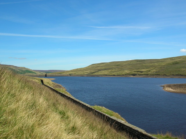
Angram Reservoir

Angram Reservoir is the first of three reservoirs on the River Nidd in Upper Nidderdale, North Yorkshire, England, the others being Scar House Reservoir...

Nidd Valley Light Railway

Nidd Valley Light Railway was a light railway in upper Nidderdale in the West Riding of Yorkshire, England. It was owned by Bradford Corporation Waterworks...

Nidd Aqueduct

The Nidd Aqueduct is an aqueduct or man-made watercourse in North Yorkshire, England. It feeds water from Angram and Scar House reservoirs in upper Nidderdale...

Nearby Amenities

Located within 500m of 54.160041,-1.9258147
Aygill Pike
Natural: peak
Source: OS OpenData StreetView
Lat/Long: 54.158262/-1.9238931
The data included in this document is from www.openstreetmap.org. The data is made available under ODbL.

Have you been to Aygill Pike?

Leave your review of Aygill Pike below (or comments, questions and feedback).