Vale of Neath
Valley in Glamorgan
Wales
Vale of Neath

The Vale of Neath, located in Glamorgan, Wales, is a picturesque and historically significant valley. Nestled between the Brecon Beacons National Park and the South Wales Valleys, it stretches along the River Neath for approximately 20 miles.
The Vale of Neath is renowned for its natural beauty, with rolling hills, lush green valleys, and cascading waterfalls. The most famous of these waterfalls is the spectacular 80-foot high Aberdulais Falls, which has been a popular tourist attraction for centuries.
The valley is rich in history, with evidence of human settlement dating back to the Stone Age. Throughout the ages, the Vale of Neath has been shaped by various industries, including ironworks, coal mining, and limestone quarries. The remnants of these industries can still be seen today in the form of old industrial buildings and derelict mines.
The village of Aberdulais, located in the heart of the valley, is home to the Aberdulais Tin Works and Waterfall, which is now managed by the National Trust. Visitors can explore the preserved 19th-century tin works and learn about the industrial heritage of the area.
The Vale of Neath also offers ample opportunities for outdoor activities, such as hiking, mountain biking, and fishing. The nearby Brecon Beacons National Park provides stunning landscapes and challenging trails for outdoor enthusiasts.
Overall, the Vale of Neath is a captivating destination, combining natural beauty, rich history, and outdoor adventures, making it a must-visit location for both locals and tourists alike.
If you have any feedback on the listing, please let us know in the comments section below.
Vale of Neath Images
Images are sourced within 2km of 51.709408/-3.7023761 or Grid Reference SN8202. Thanks to Geograph Open Source API. All images are credited.


Vale of Neath is located at Grid Ref: SN8202 (Lat: 51.709408, Lng: -3.7023761)
Unitary Authority: Neath Port Talbot
Police Authority: South Wales
Also known as: Cwm Nedd
What 3 Words
///servicing.manager.vowing. Near Resolven, Neath Port Talbot
Nearby Locations
Related Wikis

Resolven
Resolven (Welsh: Resolfen) is a small village and community in Neath Port Talbot county borough, Wales. It is located in the Vale of Neath. == Location... ==
Resolven (electoral ward)
Resolven is and electoral ward of Neath Port Talbot county borough, Wales. Resolven is made up of the parishes of Resolven and Clyne and Melincourt. Resolven...
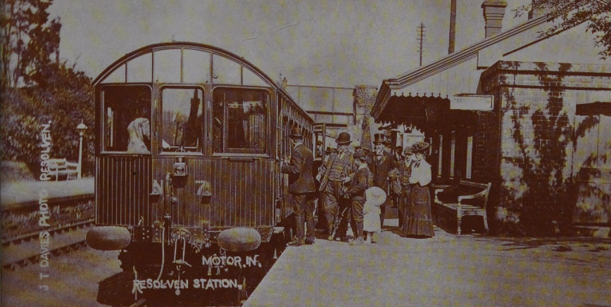
Resolven railway station
Resolven railway station served the village of Resolven, Neath Port Talbot, Wales, from 1851 to 1964 on the Vale of Neath Railway. == History == Construction...
Abergarwed
Abergarwed is a village in the Welsh county borough of Neath Port Talbot, south Wales. It is located in the Vale of Neath, in the electoral ward of Resolven...
Nearby Amenities
Located within 500m of 51.709408,-3.7023761Have you been to Vale of Neath?
Leave your review of Vale of Neath below (or comments, questions and feedback).