Vale of Ewyas

Valley in Monmouthshire

Wales

Vale of Ewyas

Former quarry Former quarry on Loxidge Tump on the Hatterrall Ridge.
Former quarry Credit: Ian Capper

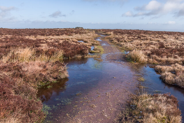
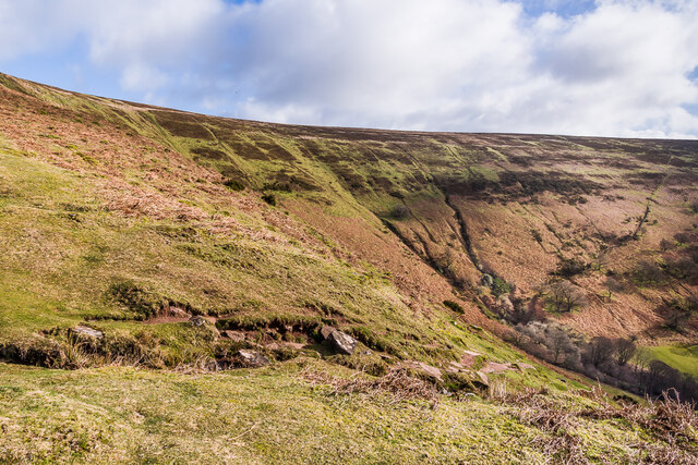
The Vale of Ewyas is a picturesque valley located in Monmouthshire, Wales. It is known for its stunning natural beauty, with rolling hills, lush greenery, and a tranquil atmosphere. The valley is surrounded by the Black Mountains to the west and the Brecon Beacons to the east, making it a popular destination for hikers and nature enthusiasts.

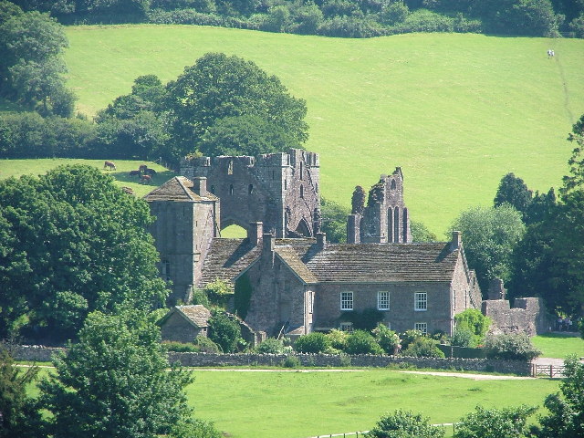
The Vale of Ewyas is home to several charming villages, including Llanthony and Capel-y-ffin, which offer visitors a glimpse into rural Welsh life. The valley is also rich in history, with ancient ruins and historic sites scattered throughout the area. One notable landmark is the ruins of Llanthony Priory, a former Augustinian priory dating back to the 12th century.

Visitors to the Vale of Ewyas can enjoy a range of outdoor activities, such as hiking, cycling, and birdwatching. The valley is also a haven for wildlife, with a variety of birds, mammals, and plant species calling the area home. Overall, the Vale of Ewyas is a peaceful and idyllic retreat for those looking to escape the hustle and bustle of everyday life and immerse themselves in nature.

If you have any feedback on the listing, please let us know in the comments section below.

Vale of Ewyas Images

Images are sourced within 2km of 51.960431/-3.0647147 or Grid Reference SO2629. Thanks to Geograph Open Source API. All images are credited.

Former quarry Former quarry on Loxidge Tump on the Hatterrall Ridge.
Former quarry
Former quarry on Loxidge Tump on the Hatterrall Ridge.
On Hatterrall Ridge Patches of water on a path from Llanthony over Loxidge Tump as it approaches the ridge line of Hatterrall Ridge.  Early morning frost has left the puddles frozen.
On Hatterrall Ridge
Patches of water on a path from Llanthony over Loxidge Tump as it approaches the ridge line of Hatterrall Ridge. Early morning frost has left the puddles frozen.
On Hatterrall Ridge Patches of water on a path from Llanthony over Loxidge Tump as it approaches the ridge line of Hatterrall Ridge.  The shelter in the background is on a minor summit on the ridge line.  Early morning frost has left the water frozen.
On Hatterrall Ridge
Patches of water on a path from Llanthony over Loxidge Tump as it approaches the ridge line of Hatterrall Ridge. The shelter in the background is on a minor summit on the ridge line. Early morning frost has left the water frozen.
On Hatterrall Ridge Looking south from Hatterrall Ridge with Skirrid and Sugar Loaf in the background.
On Hatterrall Ridge
Looking south from Hatterrall Ridge with Skirrid and Sugar Loaf in the background.
On Hatterrall Ridge A group of Welsh Mountain Ponies by a pond alongside the Offa's Dike Path on Hatterrall Ridge.
On Hatterrall Ridge
A group of Welsh Mountain Ponies by a pond alongside the Offa's Dike Path on Hatterrall Ridge.
Cwm Siarpal Steep valley below the Hatterall Ridge above Llanthony.
Cwm Siarpal
Steep valley below the Hatterall Ridge above Llanthony.
On Loxidge Tump Rough grass and heather on Loxidge Tump, with the Vale of Ewyas beyond and Llanthony Priory right of centre.  In the right background is Sugar Loaf.
On Loxidge Tump
Rough grass and heather on Loxidge Tump, with the Vale of Ewyas beyond and Llanthony Priory right of centre. In the right background is Sugar Loaf.
On Hatterrall Ridge  Path from Llanthony over Loxidge Tump as it approaches the ridge line of Hatterrall Ridge.  The cairn in the left background marks a minor summit on the ridge.
On Hatterrall Ridge
Path from Llanthony over Loxidge Tump as it approaches the ridge line of Hatterrall Ridge. The cairn in the left background marks a minor summit on the ridge.
On Hatterrall Ridge Moorland on Hatterrall Ridge, with a light dusting of snow in the background on the summit of Chwarel y Fan across the Vale of Ewyas.
On Hatterrall Ridge
Moorland on Hatterrall Ridge, with a light dusting of snow in the background on the summit of Chwarel y Fan across the Vale of Ewyas.
On Hatterrall Ridge A minor summit on Hatterrall Ridge above Llanthony.  The marker on the right is for the Offa's Dyke Path, which follows the ridge.
On Hatterrall Ridge
A minor summit on Hatterrall Ridge above Llanthony. The marker on the right is for the Offa's Dyke Path, which follows the ridge.
On Hatterrall Ridge A cairn marking a minor summit on Hatterrall Ridge above Llanthony.
On Hatterrall Ridge
A cairn marking a minor summit on Hatterrall Ridge above Llanthony.
On Hatterrall Ridge Looking along the Offa's Dyke Path on Hatterrall Ridge above Llanthony.
On Hatterrall Ridge
Looking along the Offa's Dyke Path on Hatterrall Ridge above Llanthony.
On Hatterrall Ridge Heather moorland on Hatterrall Ridge above Llanthony.  The dip beyond is the Vale of Ewyas.
On Hatterrall Ridge
Heather moorland on Hatterrall Ridge above Llanthony. The dip beyond is the Vale of Ewyas.
On Hatterrall Ridge Looking along the Offa's Dyke Path on Hatterrall Ridge.  The cairn in the background marks a minor summit on the ridge.  On the far left, with a light dusting of snow, is Chwarel y Fan across the Vale of Ewyas.
On Hatterrall Ridge
Looking along the Offa's Dyke Path on Hatterrall Ridge. The cairn in the background marks a minor summit on the ridge. On the far left, with a light dusting of snow, is Chwarel y Fan across the Vale of Ewyas.
On Hatterrall Ridge Looking along the Offa's Dyke Path on Hatterrall Ridge.  The cairn in the background marks a minor summit on the ridge.
On Hatterrall Ridge
Looking along the Offa's Dyke Path on Hatterrall Ridge. The cairn in the background marks a minor summit on the ridge.
View across the valley from Flagstone Cottage Broadley Farm, Llanthony.
View across the valley from Flagstone Cottage
Broadley Farm, Llanthony.
Ordnance Survey Cut Mark This OS cut mark can be found on an outbuilding at New House. It marks a point 250.954m above mean sea level.
Ordnance Survey Cut Mark
This OS cut mark can be found on an outbuilding at New House. It marks a point 250.954m above mean sea level.
Old lane heading south to Llanthony Part of the route from Capel y Ffin to Llanthony on the east bank of Afon Honddu. Used as a bridleway and classed as an 'other route with public access'. Difficult to believe that, within living memory, someone drove a Jaguar down here, from Trevelog to Llanthony.
Old lane heading south to Llanthony
Part of the route from Capel y Ffin to Llanthony on the east bank of Afon Honddu. Used as a bridleway and classed as an 'other route with public access'. Difficult to believe that, within living memory, someone drove a Jaguar down here, from Trevelog to Llanthony.
Show me another place!

Vale of Ewyas is located at Grid Ref: SO2629 (Lat: 51.960431, Lng: -3.0647147)

Unitary Authority: Monmouthshire

Police Authority: Gwent

Also known as: Cwm Euas

What 3 Words

///alleges.escapades.delighted. Near Llanveynoe, Herefordshire

Nearby Locations

Vale of Ewyas Cwm Euas

Related Wikis

Chwarel y Fan

Chwarel y Fan is a peak in the Black Mountains in south-eastern Wales. It is the highest rise on the long ridge which extends southeastwards from Rhos...

Capel-y-ffin

Capel-y-ffin (Welsh for 'chapel of the boundary') is a hamlet near the English-Welsh border, a couple of miles north of Llanthony in Powys, Wales. It lies...

Llanthony

Llanthony (, Welsh: Llanddewi Nant Honddu Welsh pronunciation: [ɬanˈtoːniː]) is a village in the community of Crucorney on the northern edge of Monmouthshire...

Llanthony Abbey

Llanthony Abbey is a former Anglican monastic institution founded in 1869 by Joseph Leycester Lyne (Father Ignatius), in the Welsh village of Capel-y-ffin...

Nearby Amenities

Located within 500m of 51.960431,-3.0647147
Passing Place
Lat/Long: 51.9634084/-3.063151
Passing Place
Lat/Long: 51.9615451/-3.059807
Passing Place
Lat/Long: 51.9643108/-3.0640621
Hiking: yes
Information: guidepost
Operator: Brecon Beacons National Park
Ski: yes
Tourism: information
Lat/Long: 51.9575375/-3.060484
Barrier: stile
Bicycle: no
Foot: yes
Material: wood
Source: survey
Stile: stepover
Lat/Long: 51.9581694/-3.0607733
Barrier: stile
Bicycle: no
Foot: yes
Material: wood
Source: survey
Stile: stepover
Lat/Long: 51.9592644/-3.0611727
Barrier: stile
Bicycle: no
Foot: yes
Material: wood
Source: survey
Stile: stepover
Lat/Long: 51.9606753/-3.062369
Barrier: stile
Bicycle: no
Foot: yes
Material: wood
Source: survey
Stile: stepover
Lat/Long: 51.9619643/-3.0639495
Barrier: stile
Bicycle: no
Foot: yes
Material: wood
Source: survey
Stile: stepover
Lat/Long: 51.9620764/-3.0641103
Barrier: stile
Bicycle: no
Foot: yes
Material: wood
Source: survey
Stile: stepover
Lat/Long: 51.9630095/-3.062787
Barrier: stile
Bicycle: no
Foot: yes
Material: stone
Stile: stepover
Lat/Long: 51.9606847/-3.0663639
Barrier: stile
Bicycle: no
Foot: yes
Material: wood
Stile: stepover
Lat/Long: 51.9617376/-3.0680245
Ford: yes
Source: survey
Lat/Long: 51.9632382/-3.0701903
Llanthony/Cwmyoy
Information: guidepost
Tourism: information
Lat/Long: 51.9603997/-3.0673685
The data included in this document is from www.openstreetmap.org. The data is made available under ODbL.

Have you been to Vale of Ewyas?

Leave your review of Vale of Ewyas below (or comments, questions and feedback).