Artists Valley

Valley in Cardiganshire

Wales

Artists Valley

Approaching Dynyn The public path over the hills to Pemprys leaves to the right just ahead. Easily missed (as I did) as it's quite overgrown and there is no waymarking around the farm.
Approaching Dynyn Credit: John Lucas

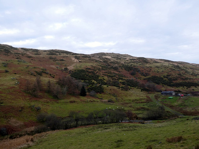
Artists Valley is a picturesque village located in the county of Cardiganshire, in Wales. Situated in the heart of the stunning Welsh countryside, the village is known for its breathtaking scenery and its thriving artistic community.

Surrounded by rolling hills and lush green landscapes, Artists Valley attracts artists, painters, and photographers from all over the world, who are drawn to the area's natural beauty and tranquility. The village has become a hub for creative individuals seeking inspiration, with many renowned artists choosing to make Artists Valley their home.

The village itself is small but charming, with traditional stone cottages lining the streets. The local community is close-knit and welcoming, with a strong emphasis on supporting and nurturing artistic talent. Artists Valley hosts regular art exhibitions, workshops, and festivals, showcasing the work of both local and international artists. Visitors have the opportunity to immerse themselves in the creative atmosphere, engage with artists, and even purchase unique pieces of art.

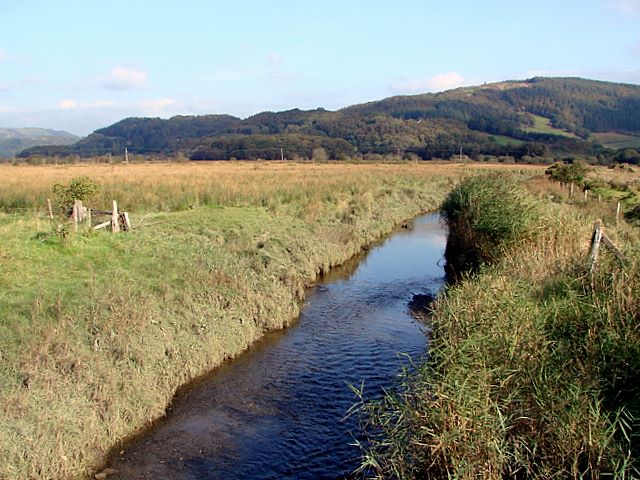
Aside from its artistic appeal, Artists Valley offers a range of outdoor activities for nature enthusiasts. The surrounding area provides ample opportunities for hiking, cycling, and exploring the nearby woodlands and rivers. The village is also close to the picturesque Cardigan Bay, with its stunning beaches and diverse wildlife.

In summary, Artists Valley is a hidden gem in Cardiganshire, offering a haven for artists and nature lovers alike. With its captivating landscapes and vibrant artistic scene, it is a destination that truly captivates the senses and leaves a lasting impression on all who visit.

If you have any feedback on the listing, please let us know in the comments section below.

Artists Valley Images

Images are sourced within 2km of 52.528293/-3.9067276 or Grid Reference SN7093. Thanks to Geograph Open Source API. All images are credited.

Approaching Dynyn The public path over the hills to Pemprys leaves to the right just ahead. Easily missed (as I did) as it's quite overgrown and there is no waymarking around the farm.
Approaching Dynyn
The public path over the hills to Pemprys leaves to the right just ahead. Easily missed (as I did) as it's quite overgrown and there is no waymarking around the farm.
Not the right path! The public path around Dynyn is not well defined and is not waymarked. I took this, the wrong path, which is not public. However my error was fortuitous as it took me into this square more easily than I had anticipated. I do hope that the landowner will not be too perturbed. I retraced my steps as soon as had realised my error.
Not the right path!
The public path around Dynyn is not well defined and is not waymarked. I took this, the wrong path, which is not public. However my error was fortuitous as it took me into this square more easily than I had anticipated. I do hope that the landowner will not be too perturbed. I retraced my steps as soon as had realised my error.
Path in Cwm Dynyn Looking back in the direction of Dynyn.
Path in Cwm Dynyn
Looking back in the direction of Dynyn.
The ford at Ystryd Einion With Afon Einion making it unwise to cross on foot today.
The ford at Ystryd Einion
With Afon Einion making it unwise to cross on foot today.
Gate on the track leading to Pemprys On a previous visit <a href="https://www.geograph.org.uk/photo/4031908">SN7093 : Farm track at Badger Lodge</a>, I concluded that the gate was padlocked and therefore barred the route to Pemprys. I should have looked more closely as I now see that the chain is merely latched, thereby allowing access to the CROW land around Pemprys Farm.
Gate on the track leading to Pemprys
On a previous visit SN7093 : Farm track at Badger Lodge, I concluded that the gate was padlocked and therefore barred the route to Pemprys. I should have looked more closely as I now see that the chain is merely latched, thereby allowing access to the CROW land around Pemprys Farm.
Old road closure notice The Artists Valley road was closed for resurfacing during the daytime for five days in March 2018. This would have been a major inconvenience for residents of the valley and highlights the difficulty of maintaining these rural single track roads.
Old road closure notice
The Artists Valley road was closed for resurfacing during the daytime for five days in March 2018. This would have been a major inconvenience for residents of the valley and highlights the difficulty of maintaining these rural single track roads.
Road bridge across Afon Pemprys Carrying the road through the Artists Valley.
Road bridge across Afon Pemprys
Carrying the road through the Artists Valley.
The road to Pemprys From Ystrad Einion. The first part of the road provides access to the forestry on Foel Einion. It then progresses onto Pemprys Farm. This area is access land which surrounds most of Pemprys, but the status of the road is unclear (to me) as there are no 'vehicles keep out' notices and there are no locked gates. The road is well maintained to Pemprys and beyond.
The road to Pemprys
From Ystrad Einion. The first part of the road provides access to the forestry on Foel Einion. It then progresses onto Pemprys Farm. This area is access land which surrounds most of Pemprys, but the status of the road is unclear (to me) as there are no 'vehicles keep out' notices and there are no locked gates. The road is well maintained to Pemprys and beyond.
The road from Ystryd Einion to Pemprys Climbing towards the Foel Einion forestry.
The road from Ystryd Einion to Pemprys
Climbing towards the Foel Einion forestry.
A first view of Pemprys On the road from Ystryd Einion through the forestry on Foel Einion. Cwm Pemprys runs out through the centre of the view.
A first view of Pemprys
On the road from Ystryd Einion through the forestry on Foel Einion. Cwm Pemprys runs out through the centre of the view.
Gate on the road from Pemprys Entering the Foel Einion forestry, leading to Ystrad Einion and the Artists Valley.
Gate on the road from Pemprys
Entering the Foel Einion forestry, leading to Ystrad Einion and the Artists Valley.
Pen Carreg Gopa Viewed from Foel Einion. Pemprys farmhouse is visible on the right.
Pen Carreg Gopa
Viewed from Foel Einion. Pemprys farmhouse is visible on the right.
Afon Pemprys Looking upstream, the source being just about a mile up the valley.
Afon Pemprys
Looking upstream, the source being just about a mile up the valley.
Afon Pemprys Looking downstream from the vicinity of Pemprys Farm. Afon Pemprys is less than 2 miles in length from its source in Bwlch Corog to its confluence with Afon Einion near Ystryd Einion.
Afon Pemprys
Looking downstream from the vicinity of Pemprys Farm. Afon Pemprys is less than 2 miles in length from its source in Bwlch Corog to its confluence with Afon Einion near Ystryd Einion.
Road leading through the Pemprys farm estate And thence climbing Foel Einion.
Road leading through the Pemprys farm estate
And thence climbing Foel Einion.
Road heading east from Pemprys The well maintained road ends about a ¼ mile ahead on the slopes of Pen Carreg Gopa. Maps show a footpath running directly ahead, towards forestry on Moel y Llyn, but it is unwise to believe everything that maps portray, as recounted by Chris Denny in <a href="https://www.geograph.org.uk/photo/1251159">SN7294 : And the path is where?</a>. I experienced a similar problem with definitive footpaths in the area when trying to access the path from the Moel y Llyn direction, from <a href="https://www.geograph.org.uk/gridref/SN7393">SN7393</a> and as described in <a href="https://www.geograph.org.uk/photo/4036325">SN7393 : 'Bridleway' through the forestry</a>.

It is interesting that the path is not shown on any old large scale maps, nor is it shown on the 1955 2½" or on the 1" 7th series sheet of 1960. The earliest record that I have found is on the 1974 1:50k map. This is unusual as most rights of way in these rural Welsh areas have a historical origin, be it from use as farm or miners' tracks or as drove roads.

You have to wonder why this path was suddenly recorded in the 1970s, effectively running from nowhere to nowhere and of which no trace now remains. It's a pity that Sir Ceredigion is so unresponsive on this, some background information would have been valuable. However, I'm afraid that my dealings with the council, on unrelated matters, have proved to be just as unsatisfactory!
Road heading east from Pemprys
The well maintained road ends about a ¼ mile ahead on the slopes of Pen Carreg Gopa. Maps show a footpath running directly ahead, towards forestry on Moel y Llyn, but it is unwise to believe everything that maps portray, as recounted by Chris Denny in SN7294 : And the path is where?. I experienced a similar problem with definitive footpaths in the area when trying to access the path from the Moel y Llyn direction, from SN7393 and as described in SN7393 : 'Bridleway' through the forestry. It is interesting that the path is not shown on any old large scale maps, nor is it shown on the 1955 2½" or on the 1" 7th series sheet of 1960. The earliest record that I have found is on the 1974 1:50k map. This is unusual as most rights of way in these rural Welsh areas have a historical origin, be it from use as farm or miners' tracks or as drove roads. You have to wonder why this path was suddenly recorded in the 1970s, effectively running from nowhere to nowhere and of which no trace now remains. It's a pity that Sir Ceredigion is so unresponsive on this, some background information would have been valuable. However, I'm afraid that my dealings with the council, on unrelated matters, have proved to be just as unsatisfactory!
Dry-stone wall on the slopes of Pen Carreg Gopa In Cwm Pemprys.
Dry-stone wall on the slopes of Pen Carreg Gopa
In Cwm Pemprys.
Looking up towards Pen Carreg Gopa From Cwm Pemprys.
Looking up towards Pen Carreg Gopa
From Cwm Pemprys.
Show me another place!

Artists Valley is located at Grid Ref: SN7093 (Lat: 52.528293, Lng: -3.9067276)

Unitary Authority: Ceredigion

Police Authority: Dyfed Powys

Also known as: Cwm Einion

What 3 Words

///highs.riverside.brimmed. Near Machynlleth, Powys

Related Wikis

Ystrad Einion

Ystrad Einion or Ystrad-Einion is a small village in the community of Ysgubor-y-coed, Ceredigion, Wales, which is 78.7 miles (126.7 km) from Cardiff and...

Coed Cwm Einion

Coed Cwm Einion is a woodland to the east of the village of Furnace, in Ceredigion, west Wales. It is designated a Site of Special Scientific Interest...

Coed y Garth, Ceredigion

Coed y Garth is a small village in the community of Ysgubor-y-coed, Ceredigion, Wales, which is 79.7 miles (128.2 km) from Cardiff and 176.9 miles (284...

Dyfi Furnace

Dyfi Furnace is a restored mid 18th century charcoal fired blast furnace used for smelting iron ore. It has given its name to the adjoining hamlet of Furnace...

Furnace, Ceredigion

Furnace (Welsh: Ffwrnais) is a hamlet in Ceredigion, Wales on the A487 trunk road from Machynlleth to Aberystwyth, near Eglwysfach. It is the location...

Eglwys Fach

Eglwys Fach, also known as Eglwys-fach or Eglwysfach, is a small village, roughly 12 miles (19 km) outside of Aberystwyth, Ceredigion. It is known for...

Glandyfi Castle

Glandyfi Castle in Glandyfi, Ceredigion, Wales, is a mock castle dating from the early 19th century. It was built for George Jeffreys, a barrister and...

Afon Llyfnant

The River Llyfnant (Welsh: Afon Llyfnant) is a short river in Ceredigion, on the west coast of Wales. The river rises in the mountains south of Machynlleth...

Nearby Amenities

Located within 500m of 52.528293,-3.9067276
Building: yes
Lat/Long: 52.5315974/-3.910618
Parking
Parking: surface
Source: GPS
Lat/Long: 52.5286856/-3.9066824
Ystrad Einion Copper Mine
Historic: mine
Man Made: adit
Mineral: zinc;lead;copper
Source: GPS
Lat/Long: 52.5282855/-3.9078292
Ford: yes
Lat/Long: 52.5282689/-3.9062969
The data included in this document is from www.openstreetmap.org. The data is made available under ODbL.

Have you been to Artists Valley?

Leave your review of Artists Valley below (or comments, questions and feedback).