Vale of Kent

Valley in Kent Tunbridge Wells

England

Vale of Kent

Carpenters Arms
Carpenters Arms Credit: Angela Tuff

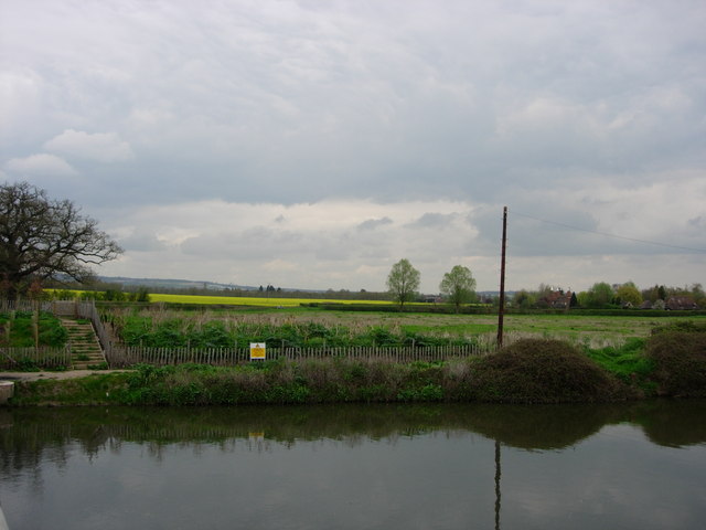
The Vale of Kent, also known as the Kent Valley, is a picturesque region located in the county of Kent, in southeastern England. Situated between the North Downs and the Weald, it covers a wide expanse of land, stretching from the outskirts of London to the English Channel.

The Vale of Kent is renowned for its beautiful landscapes and charming countryside. The region is characterized by rolling hills, lush green meadows, and fertile farmland. The area is dotted with quaint villages and historic market towns, such as Maidstone, Tonbridge, and Ashford.

The agricultural heritage of the Vale of Kent is evident in its thriving farming industry. The rich soil and favorable climate make it an ideal location for growing a variety of crops, including apples, barley, hops, and cherries. In fact, the region is famous for its apple orchards and is home to several renowned cider producers.

The Vale of Kent is also steeped in history, with numerous historic landmarks and sites of interest. Leeds Castle, often referred to as the "loveliest castle in the world," is a major attraction in the area. Additionally, the region is scattered with ancient churches, manor houses, and remnants of Roman and medieval settlements.

Transportation in the Vale of Kent is well-developed, with several major roads and railway lines connecting the area to London and other parts of the country. The region benefits from a relatively mild climate, with warm summers and mild winters, making it an appealing destination for outdoor enthusiasts and nature lovers.

Overall, the Vale of Kent offers a perfect blend of natural beauty, agricultural heritage, and historical significance, making it a must-visit destination for both locals and tourists alike.

If you have any feedback on the listing, please let us know in the comments section below.

Vale of Kent Images

Images are sourced within 2km of 51.195467/0.31222349 or Grid Reference TQ6146. Thanks to Geograph Open Source API. All images are credited.

Carpenters Arms
Carpenters Arms
Drainage Dyke Hammer Dyke between Tudeley and Golden Green.  Oilseed rape in the background.
Drainage Dyke
Hammer Dyke between Tudeley and Golden Green. Oilseed rape in the background.
River Medway The River Medway near Tonbridge. Fields of oilseed rape in the distance.
River Medway
The River Medway near Tonbridge. Fields of oilseed rape in the distance.
Railway Cutting Railway line between Redhill and Ashford. Taken from the railway bridge between Tonbridge and Paddock Wood.
Railway Cutting
Railway line between Redhill and Ashford. Taken from the railway bridge between Tonbridge and Paddock Wood.
River Medway near Tonbridge The River Medway taken from a bridge on Hartlake Road.
River Medway near Tonbridge
The River Medway taken from a bridge on Hartlake Road.
River Medway near Tonbridge Taken in a squall looking downstream off the gravel pit workings bridge, the white streaks on the image are raindrops. The footpath on the left side of the river is on both the Wealdway and the Medway Valley Walk.
River Medway near Tonbridge
Taken in a squall looking downstream off the gravel pit workings bridge, the white streaks on the image are raindrops. The footpath on the left side of the river is on both the Wealdway and the Medway Valley Walk.
River Medway: Eldridges Lock Recent heavy rain has raised water levels in the River Medway, and has now flooded the lock, with water flowing over the downstream lock gates.
River Medway: Eldridges Lock
Recent heavy rain has raised water levels in the River Medway, and has now flooded the lock, with water flowing over the downstream lock gates.
Botany Stream in Tonbridge A watercourse that runs parallel to the River Medway, bypassing Town Lock, and viewed here looking downstream from Postern Bridge.
Botany Stream in Tonbridge
A watercourse that runs parallel to the River Medway, bypassing Town Lock, and viewed here looking downstream from Postern Bridge.
River Medway near Tonbridge This weir is at the start of the channel that bypasses Eldridges Lock <a href="https://www.geograph.org.uk/photo/175032">TQ6147 : River Medway: Eldridges Lock</a> and is designed to take excess water in the River Medway from upstream of the lock to downstream of it. However the photograph was taken during a day of heavy rain, as evidenced by the threatening sky, and water levels were generally high. The footbridge takes the Medway Valley Walk over the bypass channel.
River Medway near Tonbridge
This weir is at the start of the channel that bypasses Eldridges Lock TQ6147 : River Medway: Eldridges Lock and is designed to take excess water in the River Medway from upstream of the lock to downstream of it. However the photograph was taken during a day of heavy rain, as evidenced by the threatening sky, and water levels were generally high. The footbridge takes the Medway Valley Walk over the bypass channel.
Somerhill This 17th century manor house is part of the South Frith estate, dating back to Elizabethan times, on the southern edge of Tonbridge. It is now occupied by 3 prep schools collectively known as "The Schools at Somerhill".
Grade I listed. <span class="nowrap"><a title="http://www.britishlistedbuildings.co.uk/en-436723-somerhill-capel-kent" rel="nofollow ugc noopener" href="http://www.britishlistedbuildings.co.uk/en-436723-somerhill-capel-kent">Link</a><img style="margin-left:2px;" alt="External link" title="External link - shift click to open in new window" src="https://s1.geograph.org.uk/img/external.png" width="10" height="10"/></span>
Somerhill
This 17th century manor house is part of the South Frith estate, dating back to Elizabethan times, on the southern edge of Tonbridge. It is now occupied by 3 prep schools collectively known as "The Schools at Somerhill". Grade I listed. LinkExternal link
Clocktower, Summerhill Part of the large Summerhill manor house dating back to the 17th century. Now 3 schools.
Clocktower, Summerhill
Part of the large Summerhill manor house dating back to the 17th century. Now 3 schools.
Postern Lane. Small byway, East of Tonbridge
Postern Lane.
Small byway, East of Tonbridge
Goldsmid Hall A christian centre, East of Tonbridge.
Goldsmid Hall
A christian centre, East of Tonbridge.
Public footpath leading off the B2017, East of Tonbridge. The B2017 is a short (4 miles) rural road from Tonbridge to Paddock Wood <a href="https://www.geograph.org.uk/photo/3307155">TQ6644 : B2017</a>, Via Tudley and Five Oak Green.
Public footpath leading off the B2017, East of Tonbridge.
The B2017 is a short (4 miles) rural road from Tonbridge to Paddock Wood TQ6644 : B2017, Via Tudley and Five Oak Green.
Tudeley Church This small church is famous for its stained glass windows by Chagal.
Tudeley Church
This small church is famous for its stained glass windows by Chagal.
Converted Oast house, Tudeley Like many of the Oast houses in Kent, now a private residence.
Converted Oast house, Tudeley
Like many of the Oast houses in Kent, now a private residence.
A view across an arable field to an Crockhurst Farm Oast , Tudeley. An arable area in West Kent.
A view across an arable field to an Crockhurst Farm Oast , Tudeley.
An arable area in West Kent.
Wheat fields, North of Tudeley. Part of extensive arable crops in this area of west kent.
Wheat fields, North of Tudeley.
Part of extensive arable crops in this area of west kent.
Show me another place!

Vale of Kent is located at Grid Ref: TQ6146 (Lat: 51.195467, Lng: 0.31222349)

Administrative County: Kent

District: Tunbridge Wells

Police Authority: Kent

What 3 Words

///corn.honest.ritual. Near Tonbridge, Kent

Related Wikis

Tudeley

Tudeley is a village in the civil parish of Capel, in the Tunbridge Wells borough of Kent, England. The village is home to All Saints' Church, the only...

All Saints Church, Tudeley

All Saints Church in Tudeley, Kent, England, is the only church in the world that has all its windows in stained glass designed by Marc Chagall. ��2�...

Hartlake disaster

The Hartlake disaster was an accident in Kent, England, that resulted in the death of 30 hop-pickers on 20 October 1853. == Accident == The Hartlake bridge...

The Schools at Somerhill

Somerhill Independent School (formerly known as The Schools at Somerhill) is an independent prep school in Tonbridge, Kent, located at Somerhill House...

Yardley Court

Yardley Court is a private day preparatory school for boys in Tonbridge, Kent, England, founded in 1898 by Arthur Bickmore and his wife Lilian. It now...

Somerhill House

Somerhill House () is a Grade I listed Jacobean mansion situated near Tonbridge, Kent, United Kingdom. It was built for The 4th Earl of Clanricarde in...

Hillview School for Girls

Hillview School For Girls is a Performing Arts college with academy status in Tonbridge, Kent. It has an age range of students aged 11–18. == History... ==

Securitas depot robbery

The 2006 Securitas depot robbery in Tonbridge, England, was the UK's largest cash heist. It began with a kidnapping on the evening of 21 February 2006...

Nearby Amenities

Located within 500m of 51.195467,0.31222349
Power: pole
Lat/Long: 51.1996841/0.3126588
Power: pole
Lat/Long: 51.1997268/0.3113217
Power: pole
Lat/Long: 51.1997266/0.3139861
Power: pole
Lat/Long: 51.1997965/0.3113611
Power: pole
Lat/Long: 51.1993169/0.3155476
Power: pole
Lat/Long: 51.1997483/0.3126761
Power: pole
Lat/Long: 51.1996443/0.3139813
Power: pole
Lat/Long: 51.1994038/0.3155527
The data included in this document is from www.openstreetmap.org. The data is made available under ODbL.

Have you been to Vale of Kent?

Leave your review of Vale of Kent below (or comments, questions and feedback).