Vale of Pickering

Valley in Yorkshire Ryedale

England

Vale of Pickering

Christmas Tree plantation Christmas Trees with fresh growth near Denham Grange.
Christmas Tree plantation Credit: T Eyre

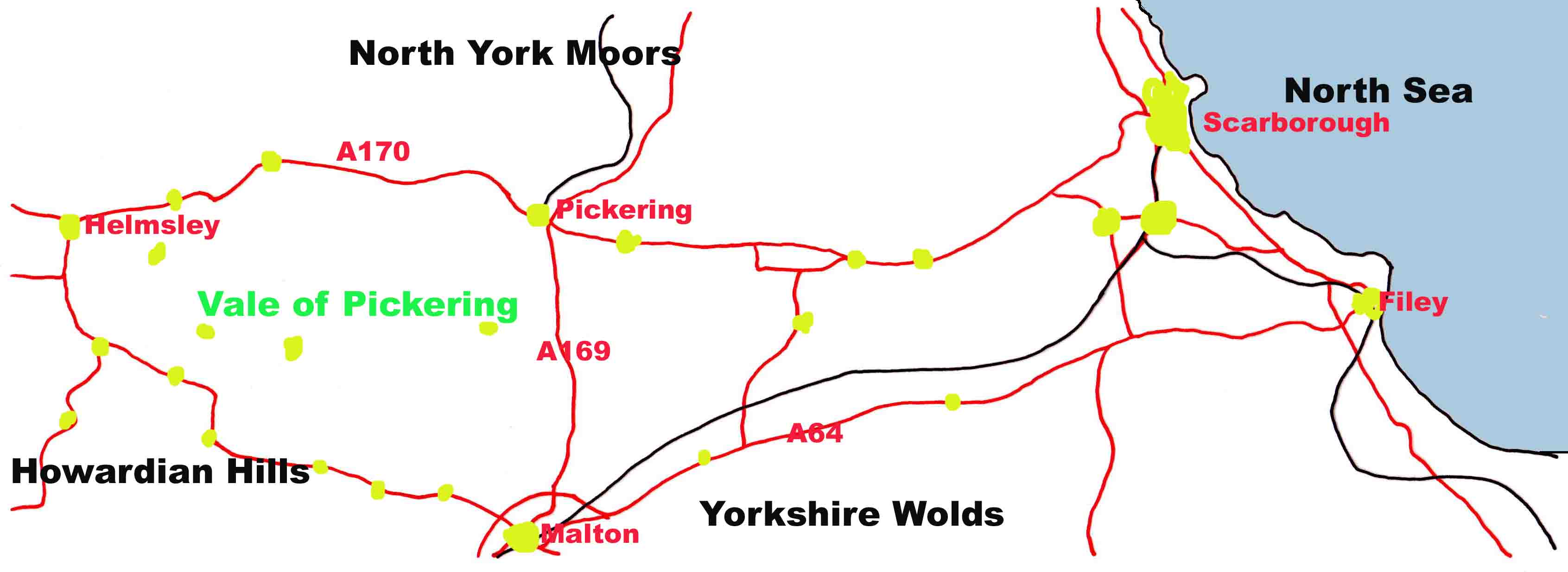
The Vale of Pickering is a picturesque valley located in the county of North Yorkshire, England. Situated between the North York Moors to the north and the Yorkshire Wolds to the south, this valley stretches approximately 35 miles from east to west. The area is renowned for its outstanding natural beauty and is a popular destination for tourists and nature enthusiasts.

The Vale of Pickering is characterized by its lush green landscape, rolling hills, and fertile farmland. The valley is crisscrossed by numerous rivers and streams, including the River Derwent and the River Rye, which add to the charm of the region. The area is known for its diverse wildlife and is home to a variety of bird species, including the rare Montagu's harrier.

Historically, the Vale of Pickering has been inhabited for thousands of years, with evidence of human presence dating back to the Mesolithic period. The valley has been shaped by its agricultural heritage, with farming being a prominent industry in the area. The fertile soil of the valley has made it ideal for crop cultivation, and it is particularly renowned for its production of barley and wheat.

The Vale of Pickering is also home to several charming villages and market towns, including Pickering, Malton, and Helmsley. These towns offer a range of amenities and attractions, including historic buildings, museums, and local markets. The area is also known for its network of walking and cycling trails, providing visitors with the opportunity to explore the stunning countryside and immerse themselves in the tranquility of the valley.

If you have any feedback on the listing, please let us know in the comments section below.

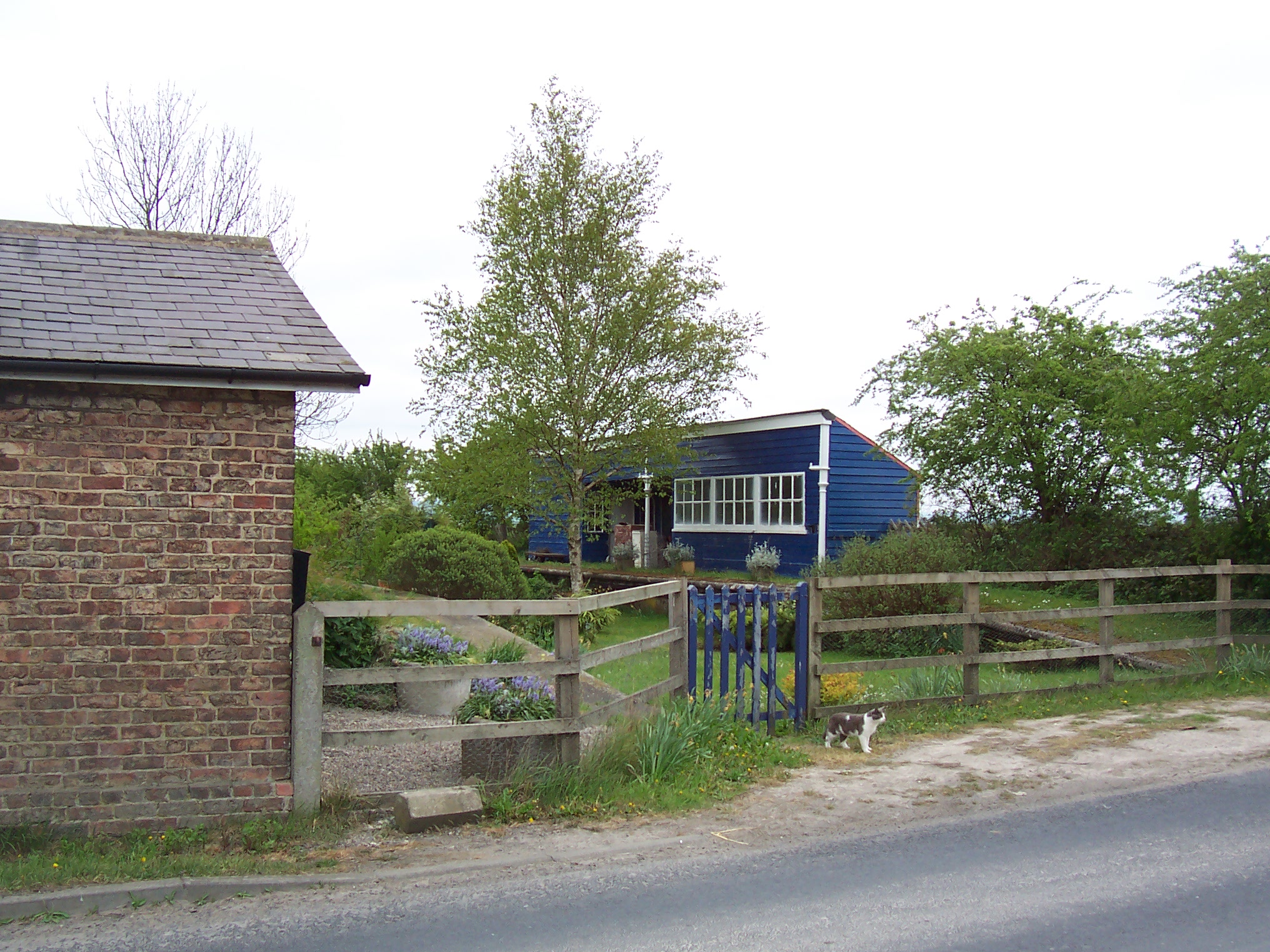
Vale of Pickering Images

Images are sourced within 2km of 54.204588/-0.72965123 or Grid Reference SE8279. Thanks to Geograph Open Source API. All images are credited.

Christmas Tree plantation Christmas Trees with fresh growth near Denham Grange.
Christmas Tree plantation
Christmas Trees with fresh growth near Denham Grange.
Speckled Wood Speckled Wood butterfly on the hedge near Selley Bridge Farm.
Speckled Wood
Speckled Wood butterfly on the hedge near Selley Bridge Farm.
Farm entrance to Wray House
White House Farm
White House Farm
Dismantled railway line Malton to Pickering branch
Dismantled railway line
Malton to Pickering branch
Bridleway across the field One of the few signposts for paths or bridleways in the area although there are plenty of paths!
There is no shortage of 'No right of way' notices however.
Bridleway across the field
One of the few signposts for paths or bridleways in the area although there are plenty of paths! There is no shortage of 'No right of way' notices however.
Turn Bridge
Turn Bridge
Entrance to Newstead Grange No evidence of a public footpath sign
Entrance to Newstead Grange
No evidence of a public footpath sign
Dismantled railway line
Mural of LNER Peppercorn Class A1 60163 Tornado The mural, on a shed by the old Marishes Road station on the Whitby & Malton branch of the L&NER, often changes. See a previous effort at <a href="https://www.geograph.org.uk/photo/211985">SE8279 : Mural of LNER No. 4468 A4 class locomotive Mallard</a>. Viewed from Thornton Lane.
Mural of LNER Peppercorn Class A1 60163 Tornado
The mural, on a shed by the old Marishes Road station on the Whitby & Malton branch of the L&NER, often changes. See a previous effort at SE8279 : Mural of LNER No. 4468 A4 class locomotive Mallard. Viewed from Thornton Lane.
Farm road to Wray House
Beck running east Viewed from Summertree Bridge.
Beck running east
Viewed from Summertree Bridge.
Summertree Bridge, Thornton Lane Traffic heading towards Thornton-le-Dale has priority on the narrow lane as it passes over the bridge.
Summertree Bridge, Thornton Lane
Traffic heading towards Thornton-le-Dale has priority on the narrow lane as it passes over the bridge.
Bridleway to Moor Close Farm From Thornton Lane.
Bridleway to Moor Close Farm
From Thornton Lane.
Marishes Road railway station (site), Yorkshire Opened in 1845 by the York & North Midland Railway on the line from Malton to Pickering, this station closed in 1965. View south east towards Rillington Junction and Malton. 
Both the former station building (left) and wooden waiting shelter (right) still survived when this image was taken.
Marishes Road railway station (site), Yorkshire
Opened in 1845 by the York & North Midland Railway on the line from Malton to Pickering, this station closed in 1965. View south east towards Rillington Junction and Malton. Both the former station building (left) and wooden waiting shelter (right) still survived when this image was taken.
Wray House Zoomed shot from Thornton Lane.
Wray House
Zoomed shot from Thornton Lane.
Harvested crop field Near Wray House, viewed from Thornton Lane.
Harvested crop field
Near Wray House, viewed from Thornton Lane.
Low Newstead Grange The farmyard entrance.
Low Newstead Grange
The farmyard entrance.
Show me another place!

Vale of Pickering is located at Grid Ref: SE8279 (Lat: 54.204588, Lng: -0.72965123)

Division: North Riding

Administrative County: North Yorkshire

District: Ryedale

Police Authority: North Yorkshire

What 3 Words

///mornings.vaulting.goat. Near Thornton Dale, North Yorkshire

Nearby Locations

Vale of Pickering

Related Wikis

Lake Pickering

Lake Pickering was an extensive proglacial lake of the Devensian glacial. It filled the Vale of Pickering between the North York Moors and the Yorkshire...

Marishes Road railway station

Marishes Road railway station was a railway station on the York and North Midland Railway's branch line to Pickering. It opened on 5 July 1845, and until...

Vale of Pickering

The Vale of Pickering is a low-lying flat area of land in North Yorkshire, England. It is drained by the River Derwent. The landscape is rural with scattered...

Marishes

Marishes is a civil parish in North Yorkshire, England. The parish has an area of some 2,960 acres (1,199 hectares), and is located between Malton and...

Nearby Amenities

Located within 500m of 54.204588,-0.72965123
Fixme: Where does the public bridleway go from here?
Lat/Long: 54.2010246/-0.7308357
Note: I'm guessing there must be a gate here
Lat/Long: 54.2056603/-0.7336593
The data included in this document is from www.openstreetmap.org. The data is made available under ODbL.

Have you been to Vale of Pickering?

Leave your review of Vale of Pickering below (or comments, questions and feedback).