Blunts Dene

Valley in Durham

England

Blunts Dene

The Village, Castle Eden A quiet no through road called simply The Village leads to the parish church, an 18th century mansion called The Castle, and a handful of other houses.
Just because it has a bright red door, the nearest building looks like an old fire station, but I don't suppose it was.
The Village, Castle Eden Credit: Des Blenkinsopp

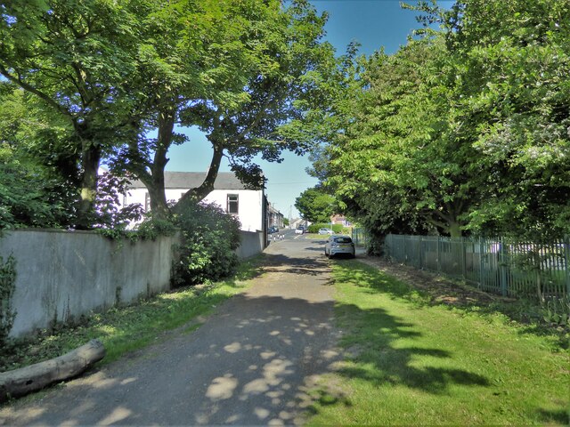
Blunts Dene, also known as Blunt's Wood, is a picturesque valley located in County Durham, England. Situated near the village of Lanchester, this hidden gem offers a tranquil and scenic escape from the hustle and bustle of nearby urban areas.

Blunts Dene is characterized by its dense woodland, featuring a variety of tree species such as oak, beech, and birch. The valley is intersected by a charming stream, which adds to its natural beauty and creates a peaceful ambiance. The sound of flowing water complements the soothing atmosphere, making it a popular spot for relaxation and contemplation.

The valley is home to an array of wildlife, including birds, small mammals, and insects. Nature enthusiasts can enjoy birdwatching and wildlife spotting as they wander along the numerous footpaths that crisscross the area. There are also designated nature trails that provide information about the flora and fauna found in Blunts Dene.

Blunts Dene is a haven for outdoor enthusiasts and walkers. The valley offers a network of well-maintained trails, allowing visitors to explore its enchanting surroundings. The trails cater to different abilities, ranging from easy strolls to more challenging hikes. Along the way, walkers can enjoy breathtaking views of the surrounding countryside and take in the seasonal beauty of the changing landscape.

Overall, Blunts Dene is a picturesque and peaceful valley in Durham. Its natural beauty, diverse wildlife, and well-maintained trails make it an ideal destination for those seeking a serene and scenic outdoor experience.

If you have any feedback on the listing, please let us know in the comments section below.

Blunts Dene Images

Images are sourced within 2km of 54.750814/-1.3299073 or Grid Reference NZ4339. Thanks to Geograph Open Source API. All images are credited.

The Village, Castle Eden A quiet no through road called simply The Village leads to the parish church, an 18th century mansion called The Castle, and a handful of other houses.
Just because it has a bright red door, the nearest building looks like an old fire station, but I don't suppose it was.
The Village, Castle Eden
A quiet no through road called simply The Village leads to the parish church, an 18th century mansion called The Castle, and a handful of other houses. Just because it has a bright red door, the nearest building looks like an old fire station, but I don't suppose it was.
Shotton Hall, Peterlee, south frontage 18th to 19th century rebuild of earlier manor house, now used by Peterlee Town Council as offices, conference centre, function suites.
Shotton Hall, Peterlee, south frontage
18th to 19th century rebuild of earlier manor house, now used by Peterlee Town Council as offices, conference centre, function suites.
North side of Shotton Hall, Peterlee
Hardwicke Hall Manor Hotel car park Shared with Manor Motors and hopefully the car stock does not get mixed up.
Hardwicke Hall Manor Hotel car park
Shared with Manor Motors and hopefully the car stock does not get mixed up.
Hesleden WMC On Front Street
Hesleden WMC
On Front Street
Bridleway approaching Church Street The bridleway enters Hesleden by the side of Hesleden House
Bridleway approaching Church Street
The bridleway enters Hesleden by the side of Hesleden House
Cycle path following route of former railway Approaching a dangerous crossing of a track used by quarry wagons. To the left of this view is a former colliery spoil heap which is being remediated.
Cycle path following route of former railway
Approaching a dangerous crossing of a track used by quarry wagons. To the left of this view is a former colliery spoil heap which is being remediated.
Church of St James
Church of St James
Drive to Hardwicke Hall Manor Hotel Passing the entrance to Wood Cottage, screened by trees
Drive to Hardwicke Hall Manor Hotel
Passing the entrance to Wood Cottage, screened by trees
Co-operative Buildings, Cotsford Lane Presumably all a co-op store at one time, but now only partly retained as a co-op funeral parlour at the far end.
Co-operative Buildings, Cotsford Lane
Presumably all a co-op store at one time, but now only partly retained as a co-op funeral parlour at the far end.
Fourth Street, Horden A very short street leading to a green. In between the much longer Third and Fifth Streets.
Fourth Street, Horden
A very short street leading to a green. In between the much longer Third and Fifth Streets.
Horden, South Terrace The OS Flush Bracket G4888 is embedded into the roadside wall on the north side of the road. This is the boundary wall to Horden Catholic Social Club.
Horden, South Terrace
The OS Flush Bracket G4888 is embedded into the roadside wall on the north side of the road. This is the boundary wall to Horden Catholic Social Club.
Horden, St Mary's church The benchmark is cut into the south-west facing wall of the church.
Horden, St Mary's church
The benchmark is cut into the south-west facing wall of the church.
Horden, St Mary's church There is a benchmark cut into the south-west facing wall of the church.
Horden, St Mary's church
There is a benchmark cut into the south-west facing wall of the church.
Lee House From the roof top car park to the Wilko store at Peterlee. A typical piece of architecture for a new town in the second half of the 20th century.
Lee House
From the roof top car park to the Wilko store at Peterlee. A typical piece of architecture for a new town in the second half of the 20th century.
Peterlee Memorial Methodist Church Part of the new town
Peterlee Memorial Methodist Church
Part of the new town
The former Victoria Billiard Hall On Dene Street
The former Victoria Billiard Hall
On Dene Street
Show me another place!

Blunts Dene is located at Grid Ref: NZ4339 (Lat: 54.750814, Lng: -1.3299073)

Unitary Authority: County Durham

Police Authority: Durham

What 3 Words

///drip.mercy.chefs. Near Peterlee, Co. Durham

Related Wikis

Castle Eden Dene

Castle Eden Dene is a Site of Special Scientific Interest and National Nature Reserve in the Easington district of County Durham, England. It is located...

Peterlee Community Hospital

Peterlee Community Hospital is a health facility in O'Neill Drive, Peterlee, County Durham, England. It is managed by North Tees and Hartlepool NHS Foundation...

Apollo Pavilion

The Apollo Pavilion, also known as the Pasmore Pavilion, is a piece of public art in the new town of Peterlee in County Durham in the North East of England...

Peterlee

Peterlee is a town in County Durham, England. It lies between Sunderland to the north, Hartlepool to the south, the Durham Coast to the east and Durham...

Nearby Amenities

Located within 500m of 54.750814,-1.3299073
Bus Stop
North Blunts Community Hospital
Bus: yes
Naptan AtcoCode: 13003261E
Naptan Bearing: S
Naptan CommonName: North Blunts Community Hospital
Naptan Indicator: Hospital entrance
Naptan Landmark: Hospital entrance
Naptan NaptanCode: durapjwm
Naptan Street: Oneill Drive
Naptan Verified: no
Public Transport: platform
Source: naptan_import
Lat/Long: 54.7546695/-1.3327153
Bus Stop
Beaumont-Conyers Cr
Bus: yes
Naptan AtcoCode: 13003529D
Naptan Bearing: SE
Naptan CommonName: Beaumont-Conyers Cr
Naptan Indicator: south east bound
Naptan Landmark: Landmark not known
Naptan NaptanCode: duratdtg
Naptan Notes: on corner on approaching right hand turn bellister park - peterlee
Naptan Street: Street not known
Naptan Verified: no
Public Transport: platform
Source: naptan_import
Lat/Long: 54.7492691/-1.3328663
Power: pole
Lat/Long: 54.7522911/-1.3232079
Location Transition: yes
Power: pole
Lat/Long: 54.7529342/-1.3234351
Generator Method: photovoltaic
Generator Output Electricity: yes
Generator Source: solar
Generator Type: solar_photovoltaic_panel
Location: roof
Power: generator
Lat/Long: 54.7491135/-1.3358826
Generator Method: photovoltaic
Generator Output Electricity: yes
Generator Source: solar
Generator Type: solar_photovoltaic_panel
Location: roof
Power: generator
Lat/Long: 54.7489727/-1.3309446
Generator Method: photovoltaic
Generator Output Electricity: yes
Generator Source: solar
Generator Type: solar_photovoltaic_panel
Location: roof
Power: generator
Lat/Long: 54.7496705/-1.331647
Generator Method: photovoltaic
Generator Output Electricity: yes
Generator Source: solar
Generator Type: solar_photovoltaic_panel
Location: roof
Power: generator
Lat/Long: 54.7490513/-1.3313359
Generator Method: photovoltaic
Generator Output Electricity: yes
Generator Source: solar
Generator Type: solar_photovoltaic_panel
Location: roof
Power: generator
Lat/Long: 54.748912/-1.3348496
Generator Method: photovoltaic
Generator Output Electricity: yes
Generator Source: solar
Generator Type: solar_photovoltaic_panel
Location: roof
Power: generator
Lat/Long: 54.7488841/-1.334745
Social Facility
The Hawthorns Care Centre
Addr Postcode: SR8 5UQ
Fhrs Id: 302113
Fixme: Clarify location of care home vs medical centre
Operator: Barchester Healthcare
Social Facility: nursing_home
Website: https://www.barchester.com/home/hawthorns-care-centre
Lat/Long: 54.7547493/-1.3333556
Waste Basket
Lat/Long: 54.7539333/-1.3299667
Barrier: kissing_gate
Lat/Long: 54.752907/-1.3287408
The data included in this document is from www.openstreetmap.org. The data is made available under ODbL.

Have you been to Blunts Dene?

Leave your review of Blunts Dene below (or comments, questions and feedback).