Monsal Dale

Valley in Derbyshire Derbyshire Dales

England

Monsal Dale

Upperdale The bridge is across the River Wye.
Upperdale Credit: Garth Newton

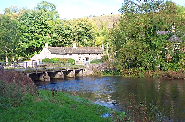
Monsal Dale, located in Derbyshire, England, is a picturesque valley known for its stunning natural beauty and rich history. Situated in the heart of the Peak District National Park, it spans approximately 8 kilometers and is carved by the River Wye.

The valley is characterized by its steep limestone cliffs, lush green meadows, and dense woodlands, creating a diverse and vibrant landscape. The river flows through the dale, adding to its charm and providing a peaceful ambiance. Visitors can enjoy leisurely walks along the riverbank, taking in the breathtaking views and immersing themselves in the tranquility of nature.

Monsal Dale is also renowned for its impressive viaduct, which was constructed in the 19th century as part of the Midland Railway. The viaduct spans the valley, offering a magnificent sight and a symbol of the area's industrial past. The Monsal Trail, a popular walking and cycling path, follows the route of the former railway track and provides a fantastic opportunity to explore the dale and its surroundings.

The valley is home to a diverse array of flora and fauna, including rare species of birds, butterflies, and wildflowers. It is a haven for nature enthusiasts and photographers, with its ever-changing landscapes and abundant wildlife.

Overall, Monsal Dale is a true gem of Derbyshire, offering visitors a chance to escape the hustle and bustle of city life and immerse themselves in the beauty of nature. Its breathtaking scenery, rich history, and diverse wildlife make it a must-visit destination for those seeking a peaceful and rejuvenating experience.

If you have any feedback on the listing, please let us know in the comments section below.

Monsal Dale Images

Images are sourced within 2km of 53.24189/-1.728355 or Grid Reference SK1871. Thanks to Geograph Open Source API. All images are credited.

Upperdale The bridge is across the River Wye.
Upperdale
The bridge is across the River Wye.
Cressbrook Mill The original mill was built by Sir Richard Arkwright in 1785, but the main building (partly obscured by the other hillside) was erected in 1815 by Arkwright's agent, William Newton. The photograph is looking northwest from the hillside above the hamlet of Upperdale.
Cressbrook Mill
The original mill was built by Sir Richard Arkwright in 1785, but the main building (partly obscured by the other hillside) was erected in 1815 by Arkwright's agent, William Newton. The photograph is looking northwest from the hillside above the hamlet of Upperdale.
Cressbrook Mill
Cressbrook Mill
Brushfield Hough Farm This is an unmodernised traditional upland farm set in a clearing amongst wooded countryside
Brushfield Hough Farm
This is an unmodernised traditional upland farm set in a clearing amongst wooded countryside
River Wye above Cressbrook Mill Limestone cliff just upstream from the weir at Cressbrook Mill.
River Wye above Cressbrook Mill
Limestone cliff just upstream from the weir at Cressbrook Mill.
Cressbrook Mill 2006 Conversion to apartments and holiday homes complete.
Cressbrook Mill 2006
Conversion to apartments and holiday homes complete.
Cressbrook Mill This building is now restored to provide luxury housing but when I took the picture it was derelict and partly supported by scaffolding. It was regarded as a very endangered building and was even included in a book by SAVE as a case study.
Cressbrook Mill
This building is now restored to provide luxury housing but when I took the picture it was derelict and partly supported by scaffolding. It was regarded as a very endangered building and was even included in a book by SAVE as a case study.
Water cum Jolly on the River Wye A wildlife haven.  The public footpath is only a little above the river's normal height and is often flooded.
Water cum Jolly on the River Wye
A wildlife haven. The public footpath is only a little above the river's normal height and is often flooded.
Cressbrook Mill Although now converted to flats, the two water turbines have been retained and are most impressive. This mill is a very fortunate survivor and the conversion has been done very sympathetically.
Cressbrook Mill
Although now converted to flats, the two water turbines have been retained and are most impressive. This mill is a very fortunate survivor and the conversion has been done very sympathetically.
Weir by Cressbrook Mill This weir provided the head for two large water turbines providing power for this mill. It would be ideal for a modern hydroelectric plant but as far as I know this has not been done (missed green opportunity).
Weir by Cressbrook Mill
This weir provided the head for two large water turbines providing power for this mill. It would be ideal for a modern hydroelectric plant but as far as I know this has not been done (missed green opportunity).
View from the bridge over the River Wye at Upperdale Whilst out green laning on my classic bike I saw this young lad being coached in the art of fly fishing next to the bridge over the River Wye. I thought it epitomized the enjoyment of the countryside.
View from the bridge over the River Wye at Upperdale
Whilst out green laning on my classic bike I saw this young lad being coached in the art of fly fishing next to the bridge over the River Wye. I thought it epitomized the enjoyment of the countryside.
Having a rest by the Bridge over the River Wye A lovely day green laning on classic bikes. The one on the left is a 40year old BSA B40 and the one on the right is a sprightly 27year old Suzuki. The one on the wall is a little older than the BSA!
Having a rest by the Bridge over the River Wye
A lovely day green laning on classic bikes. The one on the left is a 40year old BSA B40 and the one on the right is a sprightly 27year old Suzuki. The one on the wall is a little older than the BSA!
River Wye near Cressbrook Mill
Colourful climbers On the limestone cliff near Cressbrook Mill
Colourful climbers
On the limestone cliff near Cressbrook Mill
Cressbrook - Water-cum-Jolly Dale millpond
River Wye in Monsal Dale The river runs (to the right) across the southeastern corner of the square, and is seen here from the path following the right bank from Monsal Head Viaduct to White Lodge car park. Beyond are the slopes (in SK1770) below Fin Cop.
River Wye in Monsal Dale
The river runs (to the right) across the southeastern corner of the square, and is seen here from the path following the right bank from Monsal Head Viaduct to White Lodge car park. Beyond are the slopes (in SK1770) below Fin Cop.
Path by the Wye This bank of the Wye runs through the square for a mere 50 metres (the far bank for only about 20 metres). The path to Monsal Head is hemmed in between the steep wooded slopes and trees overhanging the water.
Path by the Wye
This bank of the Wye runs through the square for a mere 50 metres (the far bank for only about 20 metres). The path to Monsal Head is hemmed in between the steep wooded slopes and trees overhanging the water.
Public conveniences, White Lodge car park At the far end of the car park, an easily overlooked feature of a dramatic square at the southern end of Monsal Dale.
Public conveniences, White Lodge car park
At the far end of the car park, an easily overlooked feature of a dramatic square at the southern end of Monsal Dale.
Show me another place!

Monsal Dale is located at Grid Ref: SK1871 (Lat: 53.24189, Lng: -1.728355)

Administrative County: Derbyshire

District: Derbyshire Dales

Police Authority: Derbyshire

What 3 Words

///streak.dragons.commented. Near Tideswell, Derbyshire

Nearby Locations

Monsal Head Monsal Dale

Related Wikis

Monsal Trail

The Monsal Trail is a cycling, horse riding and walking trail in the Derbyshire Peak District. It was constructed from a section of the former Manchester...

Monsal Dale

Monsal Dale is a valley in Derbyshire, England, in the White Peak limestone area of the Peak District National Park. It is a Site of Special Scientific...

Monsal Dale railway station

Monsal Dale railway station was opened in 1866 by the Midland Railway on its line from Rowsley, extending the Manchester, Buxton, Matlock and Midlands...

Fin Cop

Fin Cop is a hill and an associated Iron Age hill fort in Monsal Dale, close to Ashford in the Water in Derbyshire, England.The fort shows evidence of...

Little Longstone

Little Longstone is a village and civil parish in Derbyshire, England. The village is on a minor road west of Great Longstone, just off the B6465 road...

Great Longstone for Ashford railway station

Great Longstone for Ashford railway station was a station which served Great and Little Longstone in the Peak District of Derbyshire. It was opened in...

Great Longstone War Memorial

Great Longstone War Memorial is a 20th-century grade II listed war memorial in Great Longstone, Derbyshire. == History == The war memorial was unveiled...

Thornbridge Hall

Thornbridge Hall (originally Thornbridge House) is a large English country house situated near the village of Great Longstone in the local government district...

Nearby Amenities

Located within 500m of 53.24189,-1.728355
Barrier: stile
Bicycle: no
Foot: yes
Stile: squeezer
Lat/Long: 53.2428067/-1.7292956
Post Box
Collection Times: Mo-Fr 09:00; Sa 07:00
Operator: Royal Mail
Post Box Type: wall
Ref: DE45 1259D
Royal Cypher: GR
Royal Cypher Wikidata: Q33102273
Source Location: survey
Lat/Long: 53.2406977/-1.7239894
Monsal Head
Tourism: viewpoint
Lat/Long: 53.2407216/-1.7246372
Bus Stop
Monsal Head (Hotel)
Bus: yes
Ele: 225.5533447
Public Transport: platform
Lat/Long: 53.2409726/-1.7241797
Bus Stop
Monsal Head (Longstone Lane)
Bench: no
Bin: no
Bus: yes
Lit: no
Public Transport: platform
Shelter: no
Tactile Paving: no
Lat/Long: 53.2406073/-1.7235739
Barrier: stile
Bicycle: no
Foot: yes
Stile: squeezer
Lat/Long: 53.2426974/-1.7295379
Barrier: stile
Foot: yes
Lat/Long: 53.2434352/-1.7320738
Bench
Lat/Long: 53.2414935/-1.7291296
Monsal Dale - Monsale trail
Check Date: 2023-02-14
Information: board
Operator: Peak District National Park Authority
Tourism: information
Lat/Long: 53.2406592/-1.7274553
Monsal Head
Place: hamlet
Lat/Long: 53.2407826/-1.7244055
Power: pole
Lat/Long: 53.2430767/-1.7351574
Power: pole
Lat/Long: 53.2432113/-1.7345034
Barrier: stile
Material: stone
Source: survey
Stile: squeezer
Lat/Long: 53.2405728/-1.7249989
Headstone Viaduct View
Tourism: viewpoint
Lat/Long: 53.2405841/-1.724963
Barrier: entrance
Source: survey;gps
Lat/Long: 53.2405927/-1.7249908
Bench
Backrest: yes
Source: survey;gps
Lat/Long: 53.2406282/-1.7247384
Barrier: stile
Material: stone
Source: survey
Stile: squeezer
Lat/Long: 53.2406603/-1.7249394
Bench
Backrest: yes
Source: survey;gps
Lat/Long: 53.2406595/-1.7247451
Bench
Backrest: yes
Source: survey;gps
Lat/Long: 53.2406759/-1.7247264
Bench
Backrest: yes
Source: survey;gps
Lat/Long: 53.2407257/-1.7246928
Bench
Backrest: yes
Source: survey;gps
Lat/Long: 53.2407715/-1.7246439
Bench
Backrest: yes
Source: survey;gps
Lat/Long: 53.2408092/-1.7246063
Bench
Backrest: yes
Source: survey;gps
Lat/Long: 53.2408264/-1.7245728
Shelter
Shelter Type: public_transport
Lat/Long: 53.2441641/-1.7343576
Bench
Backrest: no
Material: wood
Seats: 2
Lat/Long: 53.2410578/-1.7249695
Tourism: viewpoint
Lat/Long: 53.2403846/-1.7267418
Parking
Access: yes
Fee: no
Parking: layby
Source: Bing
Lat/Long: 53.2429817/-1.7250792
Parking
Lat/Long: 53.2435967/-1.7292455
Hiking: yes
Information: guidepost
Source: GPS survey
Tourism: information
Lat/Long: 53.2406218/-1.7250232
Hiking: yes
Information: guidepost
Source: GPS survey
Tourism: information
Lat/Long: 53.2411134/-1.724993
Monsal Head (Hotel)
Bus: yes
Public Transport: stop_position
Lat/Long: 53.2409678/-1.7242598
Monsal Head (Longstone Lane)
Bus: yes
Public Transport: stop_position
Lat/Long: 53.2406496/-1.7235814
Bicycle Parking
Bicycle Parking: stands
Capacity: 8
Covered: no
Lat/Long: 53.2406988/-1.7244874
Information: guidepost
Tourism: information
Lat/Long: 53.2414765/-1.7292123
Information: guidepost
Tourism: information
Lat/Long: 53.2436016/-1.7327563
The data included in this document is from www.openstreetmap.org. The data is made available under ODbL.

Have you been to Monsal Dale?

Leave your review of Monsal Dale below (or comments, questions and feedback).