Back Dale

Valley in Derbyshire High Peak

England

Back Dale

Green Lane to Chelmorton This green lane leads from Old Coalpit Lane into the village of Chelmorton, across the fields of Farditch farm, behind the sewage works.
Green Lane to Chelmorton Credit: Roger May

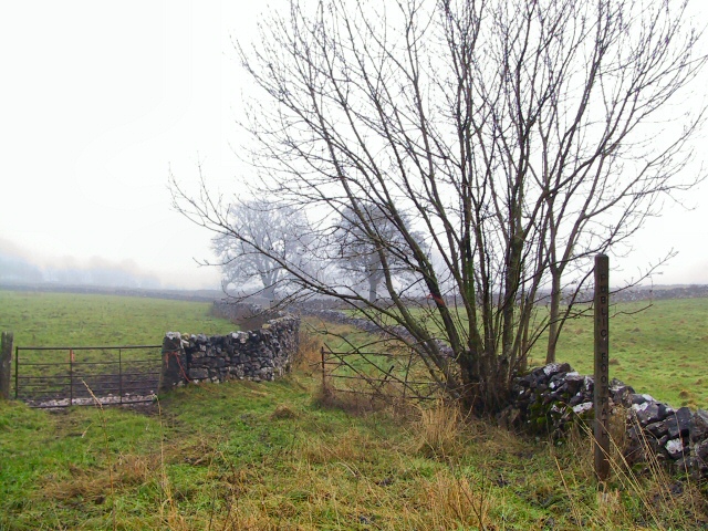
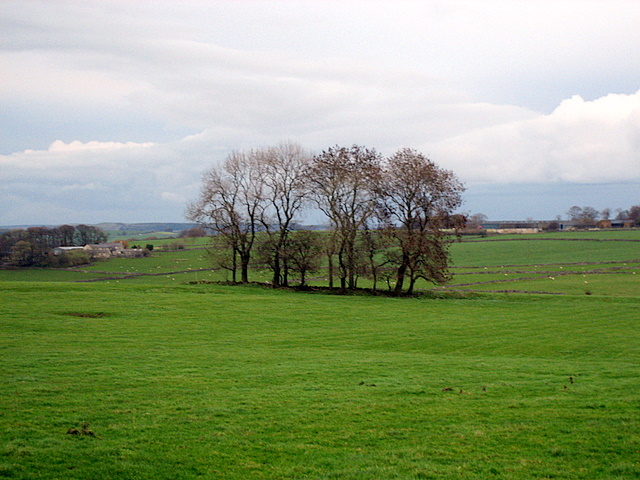
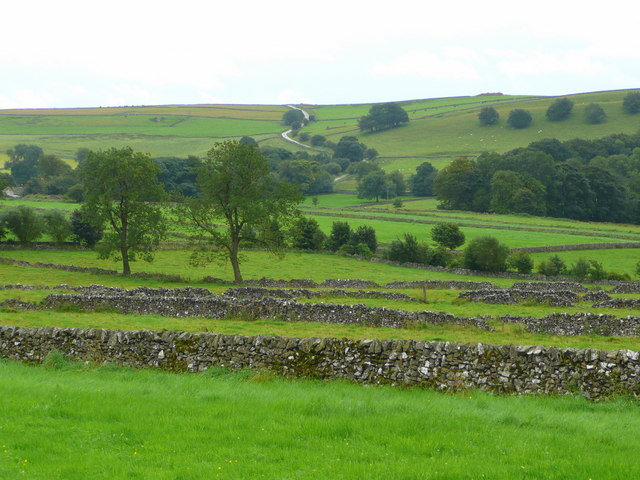
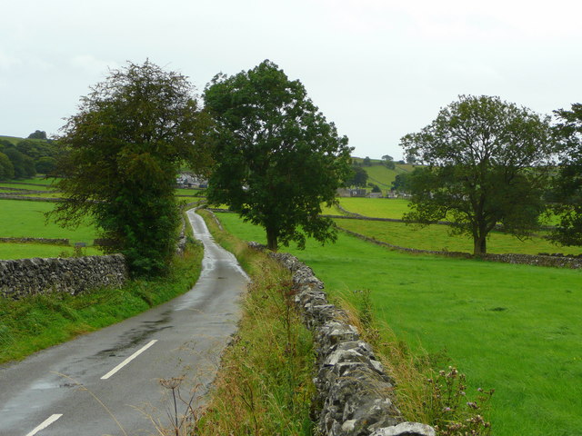
Back Dale is a picturesque valley located in the county of Derbyshire, England. Situated in the heart of the Peak District National Park, it is renowned for its stunning natural beauty and tranquil atmosphere. The valley is surrounded by rolling hills, lush green meadows, and dense woodlands, offering visitors a true escape into nature.

Back Dale is characterized by its narrow and winding road that winds through the valley, providing breathtaking views at every turn. The valley is home to an abundance of wildlife, including various bird species, deer, and rabbits, making it a popular spot for nature enthusiasts and photographers.

The peacefulness of Back Dale is further enhanced by the absence of any major developments or commercial establishments. Instead, visitors can enjoy the serenity of the valley, take leisurely walks along its numerous footpaths, or simply relax by the babbling brooks that run through it.

The valley is also steeped in history, with several ancient ruins and archaeological sites scattered throughout the area. These remnants offer a glimpse into the region's past, providing an intriguing backdrop for exploration and discovery.

Overall, Back Dale is a hidden gem in Derbyshire, offering visitors a tranquil retreat in the heart of nature. Its unspoiled beauty, diverse wildlife, and rich history make it a must-visit destination for those seeking a peaceful escape in the picturesque English countryside.

If you have any feedback on the listing, please let us know in the comments section below.

Back Dale Images

Images are sourced within 2km of 53.23101/-1.8630236 or Grid Reference SK0970. Thanks to Geograph Open Source API. All images are credited.

Green Lane to Chelmorton This green lane leads from Old Coalpit Lane into the village of Chelmorton, across the fields of Farditch farm, behind the sewage works.
Green Lane to Chelmorton
This green lane leads from Old Coalpit Lane into the village of Chelmorton, across the fields of Farditch farm, behind the sewage works.
A  fair copse! Large exposed fields on the top of this limestone country are broken up only occasionally by clumps of trees.  This contrasts with the deep valleys cut into this limestone which support extensive areas of woodland.
A fair copse!
Large exposed fields on the top of this limestone country are broken up only occasionally by clumps of trees. This contrasts with the deep valleys cut into this limestone which support extensive areas of woodland.
View south of Common Lane, Chelmorton Looking across the enclosures to Pippenwell Road ascending the hillside beyond.
View south of Common Lane, Chelmorton
Looking across the enclosures to Pippenwell Road ascending the hillside beyond.
Common Lane, Chelmorton Looking towards the village from Old Coalpit Lane.
Common Lane, Chelmorton
Looking towards the village from Old Coalpit Lane.
Beef pasture Rich grassland of the White Peak; the hill beyond is Chelmorton Low (446m).
Beef pasture
Rich grassland of the White Peak; the hill beyond is Chelmorton Low (446m).
Common Lane near Chelmorton
Footpath near Topley Pike Quarry, Deep Dale
Chelmorton Low
Chelmorton Low
Pasture land off Old Coal Pit Lane (A5270)
Sharp Bend on Old Coal Pit Lane (A5270) Approaching junction with The Ditch.
Sharp Bend on Old Coal Pit Lane (A5270)
Approaching junction with The Ditch.
Fields and walls, in the land west of Chelmorton
Leafy lane near Chelmorton
Sewage treatment works on Old Coalpit Lane
Stream goes into a culvert Ahead is Topley Pike Quarry; the stream flows in a culvert to re-emerge into the River Wye at  SK 102 724
Stream goes into a culvert
Ahead is Topley Pike Quarry; the stream flows in a culvert to re-emerge into the River Wye at SK 102 724
PNFS signpost shows the way Peak & Northern Footpaths Society sign near Topley Pike Quarry
PNFS signpost shows the way
Peak & Northern Footpaths Society sign near Topley Pike Quarry
On footpath going up to Churn Hole A steep ascent, a bit of a scramble, on footpath from Topley Pike Quarry to Chelmorton
On footpath going up to Churn Hole
A steep ascent, a bit of a scramble, on footpath from Topley Pike Quarry to Chelmorton
Looking down from Churn Hole On path from Topley Pike Quarry to Chelmorton
Looking down from Churn Hole
On path from Topley Pike Quarry to Chelmorton
Stile on path going south from Churn Hole Just beyond the stile is a circular hollow mound, of small rocks, now grassed over, one of the remains of the settlement once at this spot
Stile on path going south from Churn Hole
Just beyond the stile is a circular hollow mound, of small rocks, now grassed over, one of the remains of the settlement once at this spot
Show me another place!

Back Dale is located at Grid Ref: SK0970 (Lat: 53.23101, Lng: -1.8630236)

Administrative County: Derbyshire

District: High Peak

Police Authority: Derbyshire

What 3 Words

///stopped.remarried.guideline. Near Buxton, Derbyshire

Related Wikis

Deep Dale

Deep Dale is a short steep-sided gorge near Buxton, Derbyshire, in the Peak District of England. It is distinct from another Deep Dale, near Sheldon, 4...

Hindlow railway station

Hindlow railway station was opened for goods in 1833 near to Hindlow near King Sterndale to the south east of Buxton, Derbyshire on the Cromford and High...

King Sterndale

King Sterndale is a village and civil parish in Derbyshire, England. It is located in the Peak District, 4 miles east of Buxton. It has a population of...

Wye Valley, Derbyshire

The Wye Valley is the limestone valley of the River Wye in the White Peak of Derbyshire, England. The source of the River Wye is west of Buxton on Axe...

Chelmorton

Chelmorton is a village and a civil parish in Derbyshire, England. It is in the Derbyshire Dales district and the nearest towns are Buxton to the northwest...

Green Fairfield

Green Fairfield (Old English Green, beautiful open-land). is a civil parish in Derbyshire, England. The population of the civil parish (including Tunstead...

Harpur Hill Quarry

Harpur Hill Quarry is a disused limestone quarry on Harpur Hill, Derbyshire, England. Limestone was extracted there from 1835 to 1952 for lime burning...

Dowlow Works

Dowlow Works is a quarry in High Peak, Derbyshire near the village of Earl Sterndale. The quarry has been in operation since 1899, and has extracting permissions...

Nearby Amenities

Located within 500m of 53.23101,-1.8630236
Barrier: stile
Ele: 332.4992676
Material: stone
Source: survey;gps
Steps: 3
Stile: stepover
Lat/Long: 53.2329743/-1.8670993
Barrier: stile
Ele: 327.2119141
Material: wood
Source: survey;gps
Steps: 1
Stile: stepover
Lat/Long: 53.2313873/-1.8680199
Ele: 308.2260742
Lat/Long: 53.2306872/-1.8665674
Ele: 330.8168945
Lat/Long: 53.2346746/-1.8669683
Ele: 288.5192871
Lat/Long: 53.2287656/-1.8686504
Ele: 286.3563232
Lat/Long: 53.2294492/-1.8679564
Barrier: stile
Ele: 302.9388428
Steps: 2
Stile: stepover
Lat/Long: 53.2290966/-1.8675069
Barrier: stile
Ele: 303.9002686
Material: stone
Source: survey;gps
Steps: 4
Stile: stepover
Lat/Long: 53.2290795/-1.8673983
Barrier: stile
Ele: 316.1569824
Material: stone
Source: survey;bing
Steps: 3
Stile: stepover
Lat/Long: 53.2286987/-1.8649098
Barrier: stile
Ele: 286.1159668
Material: stone
Source: survey;gps
Steps: 2
Stile: stepover
Lat/Long: 53.2294145/-1.8680224
Ele: 304.3808594
Lat/Long: 53.2291161/-1.8674216
Ele: 302.6986084
Lat/Long: 53.2291071/-1.8674506
Barrier: stile
Ele: 311.1099854
Material: stone
Source: survey;gps
Steps: 3
Stile: squeezer
Lat/Long: 53.230216/-1.8685734
Ele: 287.5578613
Lat/Long: 53.2292595/-1.8685954
Barrier: stile
Ele: 287.7982178
Material: stone
Source: survey;gps
Steps: 3
Stile: stepover
Lat/Long: 53.2291333/-1.868567
Barrier: stile
Ele: 313.0325928
Source: survey;gps
Steps: 5
Stile: ladder
Lat/Long: 53.2268394/-1.8605318
Barrier: stile
Ele: 319.0408936
Steps: 2
Stile: wall
Lat/Long: 53.2276733/-1.8619366
Barrier: stile
Ele: 318.8005371
Steps: 2
Stile: stepover
Lat/Long: 53.2276263/-1.8618846
Ele: 318.8005371
Lat/Long: 53.2275122/-1.8616933
Ele: 319.0408936
Lat/Long: 53.2275178/-1.8616618
Ele: 319.2812500
Lat/Long: 53.2276765/-1.8619091
Ele: 319.2812500
Lat/Long: 53.2276293/-1.8618835
Ele: 319.0408936
Lat/Long: 53.227536/-1.8615645
Barrier: barrier
Ele: 312
Fixme: What sort of barrier is this? How does this relate to the stile?
Lat/Long: 53.2268105/-1.8610045
Barrier: stile
Material: stone
Source: survey;gps
Stile: stepover
Lat/Long: 53.2268358/-1.860993
Barrier: stile
Material: stone
Source: survey
Stile: stepover
Lat/Long: 53.2346038/-1.8670088
Barrier: stile
Material: stone
Source: survey;gps
Stile: stepover
Lat/Long: 53.2330928/-1.8583339
Generator Method: photovoltaic
Generator Output Electricity: yes
Generator Source: solar
Generator Type: solar_photovoltaic_panel
Location: roof
Power: generator
Lat/Long: 53.2275845/-1.860458
Generator Method: photovoltaic
Generator Output Electricity: yes
Generator Source: solar
Generator Type: solar_photovoltaic_panel
Location: roof
Power: generator
Lat/Long: 53.2273854/-1.8596171
Generator Method: photovoltaic
Generator Output Electricity: yes
Generator Source: solar
Generator Type: solar_photovoltaic_panel
Location: roof
Power: generator
Lat/Long: 53.2273621/-1.8597378
Generator Method: photovoltaic
Generator Output Electricity: yes
Generator Source: solar
Generator Type: solar_photovoltaic_panel
Location: roof
Power: generator
Lat/Long: 53.2273444/-1.8598571
The data included in this document is from www.openstreetmap.org. The data is made available under ODbL.

Have you been to Back Dale?

Leave your review of Back Dale below (or comments, questions and feedback).