Berry Clough

Valley in Derbyshire High Peak

England

Berry Clough

Path above Wildmoorstone Brook, Goyt Valley
Path above Wildmoorstone Brook, Goyt Valley Credit: Colin Park

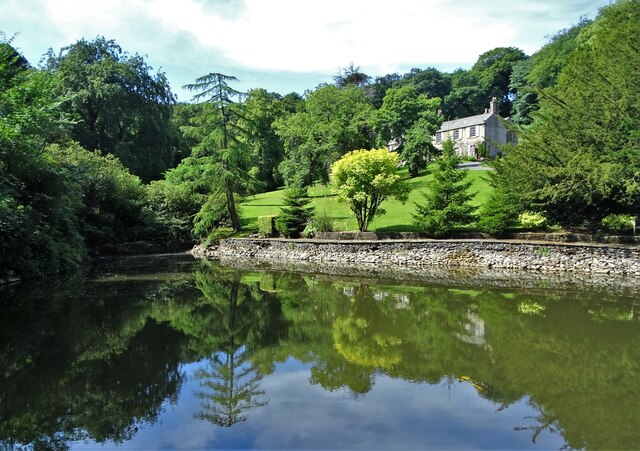
Berry Clough is a picturesque valley located in the county of Derbyshire, England. It is situated within the Peak District National Park, renowned for its stunning landscapes and natural beauty. The valley is nestled between the villages of Edale and Hayfield, and is traversed by the River Sett.

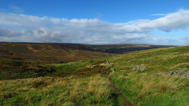
The rugged terrain of Berry Clough is characterized by steep slopes, rocky outcrops, and dense woodlands, creating a tranquil and idyllic setting. The valley is a haven for nature enthusiasts, offering a rich variety of flora and fauna. Visitors can explore the numerous walking trails and footpaths that wind their way through the valley, providing breathtaking views of the surrounding countryside.

One of the highlights of Berry Clough is its impressive waterfall, known as Kinder Downfall. This magnificent cascade is a popular attraction, especially after heavy rainfall when it transforms into a spectacular torrent of water plunging down the rocks. The waterfall is also a favorite spot for rock climbers and photographers seeking to capture its natural beauty.

The valley has a long history, with evidence of human habitation dating back to prehistoric times. There are remnants of ancient settlements and burial mounds scattered throughout the area, adding to its archaeological significance.

In addition to its natural and historical attractions, Berry Clough offers a peaceful and tranquil escape from the bustling city life. Its remote location and unspoiled beauty make it a perfect destination for those seeking solitude and a connection with nature.

If you have any feedback on the listing, please let us know in the comments section below.

Berry Clough Images

Images are sourced within 2km of 53.248342/-1.965596 or Grid Reference SK0272. Thanks to Geograph Open Source API. All images are credited.

Path above Wildmoorstone Brook, Goyt Valley
Cold air inversion near Cat & Fiddle as seen from Shining Tor The mist was creeping up from Stake Clough and Deep Clough towards the Cat & Fiddle Public House just off the photograph and to the right.
Cold air inversion near Cat & Fiddle as seen from Shining Tor
The mist was creeping up from Stake Clough and Deep Clough towards the Cat & Fiddle Public House just off the photograph and to the right.
Sheep grazing below Terret Plantation
Axe Edge Moor Looking west to the trig point on Featherbed Moss
Axe Edge Moor
Looking west to the trig point on Featherbed Moss
Axe Edge Moor Looking north over the A537 Cat & Fiddle Road to Goyt's Moss
Axe Edge Moor
Looking north over the A537 Cat & Fiddle Road to Goyt's Moss
Path towards A537 off Axe Edge Moor
The Terret descending to Ladmanlow
Lone pine tree above the Upper Goyt Valley Lone pine tree at the top of the moor that is visible for miles around.
Lone pine tree above the Upper Goyt Valley
Lone pine tree at the top of the moor that is visible for miles around.
Upper Goyt Valley Single track road above the River Goyt leads up to Derbyshire Bridge
Upper Goyt Valley
Single track road above the River Goyt leads up to Derbyshire Bridge
Daffodils in mid-May View over the Upper Goyt Valley taken from the old road with the Cat and Fiddle visible on the horizon
Daffodils in mid-May
View over the Upper Goyt Valley taken from the old road with the Cat and Fiddle visible on the horizon
Trees in full leaf Astride the Old Buxton Road west of Derbyshire Bridge.
Trees in full leaf
Astride the Old Buxton Road west of Derbyshire Bridge.
Drystone wall by the Old Buxton Road
At Edgemoor The pond is known locally as Edgemoor Pond and the house reflected in the pond is also called Edgemoor. It was once the home of George Spencer who became Bishop of Madras in India in 1837. It is believed that the approach road to this hamlet is named Bishop's Lane after him.
At Edgemoor
The pond is known locally as Edgemoor Pond and the house reflected in the pond is also called Edgemoor. It was once the home of George Spencer who became Bishop of Madras in India in 1837. It is believed that the approach road to this hamlet is named Bishop's Lane after him.
Junction of footpaths near Edgemoor The signpost guides ramblers and cyclists to Bishop's Lane. The path to the left leads to Wild Moor and the Goyt valley.
Junction of footpaths near Edgemoor
The signpost guides ramblers and cyclists to Bishop's Lane. The path to the left leads to Wild Moor and the Goyt valley.
Wild Moor With blooming heather
Wild Moor
With blooming heather
Triangulation pillar on Burbage Edge With cirrus clouds above on a warm summer's day. TP 1769.
Triangulation pillar on Burbage Edge
With cirrus clouds above on a warm summer's day. TP 1769.
End of path from Goyt's Moss Heading back to Burbage on the west side of Buxton
End of path from Goyt's Moss
Heading back to Burbage on the west side of Buxton
Semi-detached houses at Burbage, Buxton On Macclesfield Old Road
Semi-detached houses at Burbage, Buxton
On Macclesfield Old Road
Show me another place!

Berry Clough is located at Grid Ref: SK0272 (Lat: 53.248342, Lng: -1.965596)

Administrative County: Derbyshire

District: High Peak

Police Authority: Derbyshire

What 3 Words

///belonged.heartless.reported. Near Buxton, Derbyshire

Related Wikis

Burbage Edge

Burbage Edge is a gritstone escarpment overlooking the Burbage district of Buxton in Derbyshire, in the Peak District. The hill's summit (marked by a trig...

Ann Croft

Ann Croft is a place in the parish of Hartington Upper Quarter in the Hundred of Wirksworth. A croft is a small enclosed field or pasture near a house...

Buxton Pavilion Gardens

Buxton Pavilion Gardens is a Victorian landscaped public park in the spa town of Buxton in Derbyshire. The River Wye flows through the gardens, which are...

Grin Low

Grin Low is a hill overlooking Buxton in Derbyshire, in the Peak District. The summit is 434 metres (1,424 ft) above sea level.Grin Low was the main location...

Nearby Amenities

Located within 500m of 53.248342,-1.965596
Barrier: stile
Material: wood
Source: survey;gps
Stile: stepover
Lat/Long: 53.2466574/-1.9609982
Ford: yes
Lat/Long: 53.251846/-1.9656418
Barrier: stile
Material: wood
Source: survey;gps
Stile: stepover
Lat/Long: 53.2467061/-1.9601601
Hunting Stand
Hunting Stand: grouse_butt
Lat/Long: 53.2468891/-1.9724921
Hunting Stand
Hunting Stand: grouse_butt
Lat/Long: 53.2466291/-1.9720307
Hunting Stand
Hunting Stand: grouse_butt
Lat/Long: 53.2462022/-1.9712582
Disused Man Made: mineshaft
Lat/Long: 53.2462419/-1.9590586
The data included in this document is from www.openstreetmap.org. The data is made available under ODbL.

Have you been to Berry Clough?

Leave your review of Berry Clough below (or comments, questions and feedback).