Willmer Green Clough

Valley in Yorkshire

England

Willmer Green Clough

Following the Pennine Way at Rape Hill with view to White Hill
Following the Pennine Way at Rape Hill with view to White Hill Credit: Colin Park

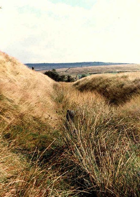
Willmer Green Clough is a picturesque valley located in Yorkshire, England. Nestled amidst rolling hills and verdant landscapes, this valley is a haven for nature enthusiasts and those seeking tranquility away from the hustle and bustle of city life.

The valley is characterized by its lush greenery and a meandering stream that flows through it, adding to its charm. The stream is lined with picturesque stone bridges, offering scenic views and photo opportunities. The valley is also home to a variety of flora and fauna, making it a perfect spot for birdwatching and nature walks.

Surrounded by a patchwork of fields and farmlands, Willmer Green Clough showcases the rural beauty of Yorkshire. The valley is dotted with charming cottages and farmhouses, adding to its idyllic atmosphere. It is common to spot grazing sheep and cows in the fields, further enhancing the rural ambiance.

For outdoor enthusiasts, the valley offers ample opportunities for hiking and exploring. There are several walking trails that wind through the valley, offering stunning views of the surrounding countryside. The trails vary in difficulty, catering to both casual strollers and more experienced hikers.

Willmer Green Clough is not only a natural paradise but also a place of historical significance. The valley has a rich heritage, with remnants of ancient settlements and historic structures. Exploring the valley provides a glimpse into the region's past and a deeper understanding of its cultural heritage.

Overall, Willmer Green Clough is a hidden gem in Yorkshire, offering a serene and picturesque escape for nature lovers and history enthusiasts alike. Its natural beauty, tranquility, and historical significance make it a must-visit destination in the region.

If you have any feedback on the listing, please let us know in the comments section below.

Willmer Green Clough Images

Images are sourced within 2km of 53.607518/-1.9863146 or Grid Reference SE0112. Thanks to Geograph Open Source API. All images are credited.

Following the Pennine Way at Rape Hill with view to White Hill
Marker post locating former most eastern point of Lancashire
Approaching trig point on Standedge from the south
Slope leading down from March Hill towards Haigh Reservoir
March Hill from path along north side of March Haigh Reservoir
Path leading east above Haigh Clough
Bank Top & Haigh Clough
Track to Readycon Reservoir
Moorland by the A640 Haigh Gutter goes off to the left. Little Moss is in the centre of the picture.
Moorland by the A640
Haigh Gutter goes off to the left. Little Moss is in the centre of the picture.
Mere Clough Moss
Mere Clough Moss
The Eastern end of Readycon Dean Reservoir
Ruined wall, fence and tower of stones, Rape Hill
Linsgreave Head
Linsgreave Head
The most easterly point of Lancashire, Milnrow This has been erected by The Friends of Real Lancashire, and is the last of a series of posts on each of the four extremities of the historic county. Actually the point is a little further east, but the post has been sited next to the Pennine Way where it can be seen by all who pass by. There is a 'dog-stile' on the right.

See <span class="nowrap"><a title="http://abcounties.com/documents/2015/03/forl-press-release-18-march-2015.pdf" rel="nofollow ugc noopener" href="http://abcounties.com/documents/2015/03/forl-press-release-18-march-2015.pdf">Link</a><img style="margin-left:2px;" alt="External link" title="External link - shift click to open in new window" src="https://s1.geograph.org.uk/img/external.png" width="10" height="10"/></span>
The most easterly point of Lancashire, Milnrow
This has been erected by The Friends of Real Lancashire, and is the last of a series of posts on each of the four extremities of the historic county. Actually the point is a little further east, but the post has been sited next to the Pennine Way where it can be seen by all who pass by. There is a 'dog-stile' on the right. See LinkExternal link
The Pennine Way approaching a stile, Milnrow The post shown in <a href="https://www.geograph.org.uk/photo/5159487">SD9912 : The most easterly point of Lancashire, Milnrow</a> is to the left of the path, and there is a sign indicating that you are entering Marsden Moor (National Trust). There is a dog-stile to the left of the normal stile.
The Pennine Way approaching a stile, Milnrow
The post shown in SD9912 : The most easterly point of Lancashire, Milnrow is to the left of the path, and there is a sign indicating that you are entering Marsden Moor (National Trust). There is a dog-stile to the left of the normal stile.
Rainbow on White Hassock It was fine and sunny in Yorkshire, whilst Lancashire was covered by dark clouds and rain. However the sun found a gap and produced this rainbow, caused by rain that had drifted over the county boundary, The crock of gold is under two metres of peat.
Rainbow on White Hassock
It was fine and sunny in Yorkshire, whilst Lancashire was covered by dark clouds and rain. However the sun found a gap and produced this rainbow, caused by rain that had drifted over the county boundary, The crock of gold is under two metres of peat.
The Pennine Way approaching a small valley, Saddleworth
The Pennine Way crossing a small valley, Saddleworth The old public footpath is a little way upstream, and the caption 'fords' appears on OS maps. The Pennine Way is evidently on a better route, and crosses two streams by stone slab bridges, with a paved path between them. The steps lead down to the first bridge.
The Pennine Way crossing a small valley, Saddleworth
The old public footpath is a little way upstream, and the caption 'fords' appears on OS maps. The Pennine Way is evidently on a better route, and crosses two streams by stone slab bridges, with a paved path between them. The steps lead down to the first bridge.
Show me another place!

Willmer Green Clough is located at Grid Ref: SE0112 (Lat: 53.607518, Lng: -1.9863146)

Division: West Riding

Unitary Authority: Kirklees

Police Authority: West Yorkshire

What 3 Words

///grinning.influence.easygoing. Near Diggle, Manchester

Related Wikis

A640 road

The A640 is a road in England which runs between Rochdale in Greater Manchester and Huddersfield in West Yorkshire. The road's most westbound point as...

Marsden Moor Estate

The Marsden Moor Estate is a large expanse of moorland in the South Pennines, between the conurbations of West Yorkshire and Greater Manchester in the...

Standedge Tunnels

The Standedge Tunnels () are four parallel tunnels through the Pennine hills at the Standedge crossing between Marsden in Kirklees, West Yorkshire and...

Castleshaw

Castleshaw is a hamlet in the Saddleworth parish of the Metropolitan Borough of Oldham in Greater Manchester, England. It lies amid the Pennines, 2.4 miles...

Standedge

Standedge () is a moorland escarpment in the Pennine Hills of northern England between Marsden, West Yorkshire and Diggle, Greater Manchester. Standedge...

Castleshaw Roman Fort

Castleshaw Roman fort was a castellum in the Roman province of Britannia. Although there is no evidence to substantiate the claim, it has been suggested...

Marsden railway station

Marsden railway station serves the village of Marsden near Huddersfield in West Yorkshire, England. The station is on the Huddersfield Line, operated by...

Denshaw

Denshaw is a village in the civil parish of Saddleworth in the Metropolitan Borough of Oldham, in Greater Manchester, England. It lies by the source of...

Nearby Amenities

Located within 500m of 53.607518,-1.9863146
Height: 1.0
Inscription: P.H.ROAD
Man Made: marker_post
Material: stone
Lat/Long: 53.6086673/-1.9850584
Height: 1.0
Inscription: P.H.ROAD
Man Made: marker_post
Material: stone
Lat/Long: 53.608161/-1.9827171
Height: 0.8
Inscription: P.H.ROAD
Man Made: marker_post
Material: stone
Lat/Long: 53.6071435/-1.9888674
The data included in this document is from www.openstreetmap.org. The data is made available under ODbL.

Have you been to Willmer Green Clough?

Leave your review of Willmer Green Clough below (or comments, questions and feedback).