Black Cleugh

Valley in Durham

England

Black Cleugh

Head of the River Wear The point where Killhope Burn and Burnhope Burn meet to become the River Wear - at the aptly named village of Wearhead.
Head of the River Wear Credit: Chris Heaton

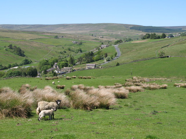
Black Cleugh is a small village located in the county of Durham in the northeast of England. Situated in the beautiful valley area, it is surrounded by stunning natural landscapes and is known for its picturesque views. The village is part of the larger community of Weardale, which is renowned for its agricultural heritage and charming countryside.

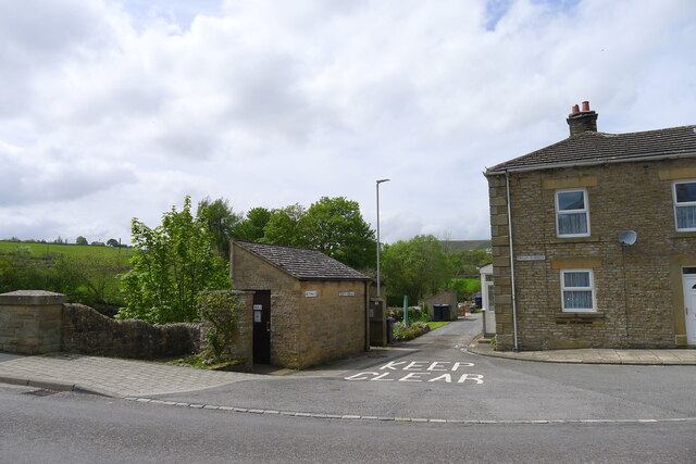
Black Cleugh is characterized by its traditional stone-built houses and cottages, which add to its rustic charm. The village is sparsely populated, with a tight-knit community that fosters a friendly and welcoming atmosphere. The residents predominantly engage in farming and other rural occupations, reflecting the area's strong agricultural roots.

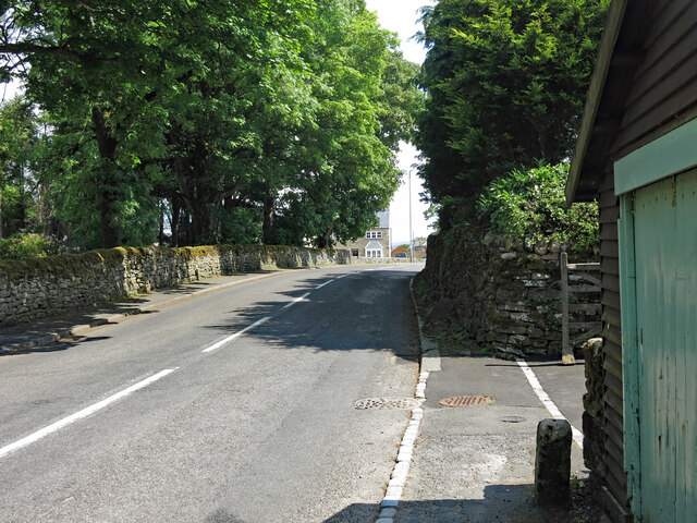
The River Wear flows through the valley, providing a scenic backdrop for the village. The surrounding hills and moorlands offer ample opportunities for outdoor activities such as hiking, cycling, and birdwatching. The area is also known for its rich wildlife, with various species of birds, mammals, and plants found in the vicinity.

Despite its small size, Black Cleugh is well-connected to nearby towns and cities. The village is within a short driving distance from the market town of Stanhope, where residents can access amenities such as shops, schools, and healthcare facilities. Additionally, the city of Durham is approximately 20 miles away, offering a wider range of services and cultural attractions.

In conclusion, Black Cleugh is a charming village in Durham Valley, offering a peaceful and idyllic setting for residents and visitors alike. With its natural beauty and close-knit community, it is an ideal destination for those seeking a tranquil rural lifestyle.

If you have any feedback on the listing, please let us know in the comments section below.

Black Cleugh Images

Images are sourced within 2km of 54.753884/-2.2476791 or Grid Reference NY8439. Thanks to Geograph Open Source API. All images are credited.

Head of the River Wear The point where Killhope Burn and Burnhope Burn meet to become the River Wear - at the aptly named village of Wearhead.
Head of the River Wear
The point where Killhope Burn and Burnhope Burn meet to become the River Wear - at the aptly named village of Wearhead.
Wearhead The A689 running through the small village of Wearhead
Wearhead
The A689 running through the small village of Wearhead
River level monitoring station on the Killhope Burn, Wearhead For information on water levels: <span class="nowrap"><a title="https://riverlevels.uk/killhope-burn-stanhope-wearhead#.YpYn1qjMJPY" rel="nofollow ugc noopener" href="https://riverlevels.uk/killhope-burn-stanhope-wearhead#.YpYn1qjMJPY">Link</a><img style="margin-left:2px;" alt="External link" title="External link - shift click to open in new window" src="https://s1.geograph.org.uk/img/external.png" width="10" height="10"/></span>
River level monitoring station on the Killhope Burn, Wearhead
For information on water levels: LinkExternal link
The head of the Wear at Wearhead The River Wear starts here, below the junction of the Burnhope Burn and the Killhope Burn. Weardale, and the Weardale Way start 4½ miles upstream at the head of the Killhope Burn
The head of the Wear at Wearhead
The River Wear starts here, below the junction of the Burnhope Burn and the Killhope Burn. Weardale, and the Weardale Way start 4½ miles upstream at the head of the Killhope Burn
Public convenience, Wearhead The villages of Weardale are well supplied with free toilets.
Public convenience, Wearhead
The villages of Weardale are well supplied with free toilets.
Old bridge marker, Wearhead The Durham Historic Environment Record (HER) <span class="nowrap"><a title="https://www.heritagegateway.org.uk/Gateway/Results_Single.aspx?uid=D8876&resourceID=109" rel="nofollow ugc noopener" href="https://www.heritagegateway.org.uk/Gateway/Results_Single.aspx?uid=D8876&resourceID=109">Link</a><img style="margin-left:2px;" alt="External link" title="External link - shift click to open in new window" src="https://s1.geograph.org.uk/img/external.png" width="10" height="10"/></span> says that this is "a stone milestone or property marker". But a longstanding local resident told me that the "C", which is the Latin letter for 100, indicated that the river (Wear) was 100 yards (presumably Roman yards) away.
The location of this stone is shown in <a href="https://www.geograph.org.uk/photo/7240849">NY8539 : Front Street, Wearhead</a> and <a href="https://www.geograph.org.uk/photo/7240852">NY8539 : Front Street, Wearhead (2)</a>.
Old bridge marker, Wearhead
The Durham Historic Environment Record (HER) LinkExternal link says that this is "a stone milestone or property marker". But a longstanding local resident told me that the "C", which is the Latin letter for 100, indicated that the river (Wear) was 100 yards (presumably Roman yards) away. The location of this stone is shown in NY8539 : Front Street, Wearhead and NY8539 : Front Street, Wearhead (2).
Front Street, Wearhead Shows the location of the <a href="https://www.geograph.org.uk/photo/7240846">NY8539 : Old bridge marker, Wearhead</a>.
Front Street, Wearhead
Shows the location of the NY8539 : Old bridge marker, Wearhead.
Front Street, Wearhead (2) Shows the location of the <a href="https://www.geograph.org.uk/photo/7240846">NY8539 : Old bridge marker, Wearhead</a>.
Front Street, Wearhead (2)
Shows the location of the NY8539 : Old bridge marker, Wearhead.
Low water in Burnhope Reservoir The reservoir in upper Weardale during August 2022, following an extended period of low rainfall.
Burnhope Seat is the hill on the horizon, its summit area being cloud-shadowed, left of centre.
Low water in Burnhope Reservoir
The reservoir in upper Weardale during August 2022, following an extended period of low rainfall. Burnhope Seat is the hill on the horizon, its summit area being cloud-shadowed, left of centre.
Path on north side of Burnhope Reservoir Maps show that if full the reservoir's water would reach close to the path. That's far from the situation in mid-August 2022 when the water level was well down.
It seems that the reservoir is not now used as a direct supply source for homes or industry but to top up when necessary, water flow in the River Wear.
Path on north side of Burnhope Reservoir
Maps show that if full the reservoir's water would reach close to the path. That's far from the situation in mid-August 2022 when the water level was well down. It seems that the reservoir is not now used as a direct supply source for homes or industry but to top up when necessary, water flow in the River Wear.
Pipeline crossing valley of Black Cleugh Being so close to Burnhope Reservoir it's assumed that the pipe carries water either to or from there. Both the pipe and the reservoir surface are close to the 400 m. contour so it's unclear in which direction, (if under gravity), water would flow.
Pipeline crossing valley of Black Cleugh
Being so close to Burnhope Reservoir it's assumed that the pipe carries water either to or from there. Both the pipe and the reservoir surface are close to the 400 m. contour so it's unclear in which direction, (if under gravity), water would flow.
Dam and spillway at Burnhope Reservoir at time of low water Despite some heavy rain in the first half of September 2022 after an extended dry spell, the water level at the Burnhope Reservoir remains very low. Were the reservoir full, excess water would be dropping over the lip of the spillway and cascading down the steps to run down and join the River Wear in the valley below.
Dam and spillway at Burnhope Reservoir at time of low water
Despite some heavy rain in the first half of September 2022 after an extended dry spell, the water level at the Burnhope Reservoir remains very low. Were the reservoir full, excess water would be dropping over the lip of the spillway and cascading down the steps to run down and join the River Wear in the valley below.
Burnhope Burn running into Burnhope Reservoir. The water level in the reservoir is well below capacity following a long dry spell of weather during the summer. Certainly, if it was full, its water would cover the distant vegetated area at the centre of the image.
Burnhope Burn running into Burnhope Reservoir.
The water level in the reservoir is well below capacity following a long dry spell of weather during the summer. Certainly, if it was full, its water would cover the distant vegetated area at the centre of the image.
Hill road leaving Grasshill Causeway The rough road appears to be heading for High House but it doesn't go directly there, instead it veers to the left to reach another building, not in view in the image, Far High House. Neither property is occupied.
Hill road leaving Grasshill Causeway
The rough road appears to be heading for High House but it doesn't go directly there, instead it veers to the left to reach another building, not in view in the image, Far High House. Neither property is occupied.
Access road and bridleway heading north from Wearhead The rising road gives access to a number of houses. It's also the route of a bridleway which can be followed easily on foot as far as the distant, parked vehicle and even beyond it, but fairly soon after that it becomes a struggle and to get a horse through the overgrown route with some fallen trees would take a prodigious effort!
Access road and bridleway heading north from Wearhead
The rising road gives access to a number of houses. It's also the route of a bridleway which can be followed easily on foot as far as the distant, parked vehicle and even beyond it, but fairly soon after that it becomes a struggle and to get a horse through the overgrown route with some fallen trees would take a prodigious effort!
Last Train waiting to leave Wearhead for Bishop Auckland View NW, towards buffer-stops; ex-NE terminus of line from Bishop Auckland, 27/6/53: the locomotive is ex-NE J21 No. 65078. Goods traffic continued up the valley as far as St John's Chapel until 2/1/61; a passenger service, Bishop Auckland - Stanhope was restored by the Weardale Railway from 23/5/10. See also <a href="https://www.geograph.org.uk/photo/2047797">NY8539 : Wearhead Station and engine shed</a> and <a href="https://www.geograph.org.uk/photo/2354831">NZ2029 : The Last Train to Wearhead waits to leave Bishop Auckland Station</a>.
Last Train waiting to leave Wearhead for Bishop Auckland
View NW, towards buffer-stops; ex-NE terminus of line from Bishop Auckland, 27/6/53: the locomotive is ex-NE J21 No. 65078. Goods traffic continued up the valley as far as St John's Chapel until 2/1/61; a passenger service, Bishop Auckland - Stanhope was restored by the Weardale Railway from 23/5/10. See also NY8539 : Wearhead Station and engine shed and NZ2029 : The Last Train to Wearhead waits to leave Bishop Auckland Station.
Downstream from bridge over River Wear at Wearhead
Front Street Wearhead
Show me another place!

Black Cleugh is located at Grid Ref: NY8439 (Lat: 54.753884, Lng: -2.2476791)

Unitary Authority: County Durham

Police Authority: Durham

What 3 Words

///defining.storyline.observers. Near Alston, Cumbria

Nearby Locations

Black Cleugh

Related Wikis

Burnhope Reservoir railway

The Burnhope Reservoir railway was an industrial narrow gauge railway built to serve the construction of Burnhope Reservoir near Weardale. An extensive...

Cowshill

Cowshill is a village in the civil parish of Stanhope, in County Durham, England. It is situated at the top of Weardale, between Lanehead and Wearhead...

Copthill

Copthill is a village in the civil parish of Stanhope, in County Durham, England. It is situated on the north side of Weardale, between Cowshill and Cornriggs...

Cornriggs

Cornriggs is a hamlet in the civil parish of Stanhope, in County Durham, England. It is situated on the north side of Weardale in the North Pennines,...

Nearby Amenities

Located within 500m of 54.753884,-2.2476791
Hunting Stand
Hunting Stand: grouse_butt
Lat/Long: 54.7549707/-2.2546515
Hunting Stand
Hunting Stand: grouse_butt
Lat/Long: 54.7549567/-2.2539595
Hunting Stand
Hunting Stand: grouse_butt
Lat/Long: 54.7549459/-2.2531495
Hunting Stand
Hunting Stand: grouse_butt
Lat/Long: 54.7549227/-2.2525191
Hunting Stand
Hunting Stand: grouse_butt
Lat/Long: 54.754918/-2.2518244
Hunting Stand
Hunting Stand: grouse_butt
Lat/Long: 54.754901/-2.2510868
Hunting Stand
Hunting Stand: grouse_butt
Lat/Long: 54.7548793/-2.2503868
Barrier: entrance
Lat/Long: 54.7529971/-2.2412968
The data included in this document is from www.openstreetmap.org. The data is made available under ODbL.

Have you been to Black Cleugh?

Leave your review of Black Cleugh below (or comments, questions and feedback).