Dun Cleuch

Valley in Roxburghshire

Scotland

Dun Cleuch

Forestry near Black Crag Various stages of commercial forestry near Black Crag in the Redesdale Forest.

This photograph was taken during the Coronavirus (COVID-19) pandemic of 2020/21/22.
Forestry near Black Crag Credit: James T M Towill

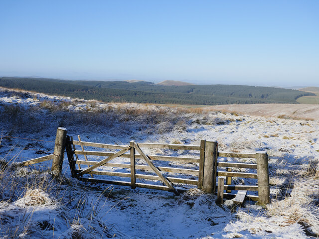
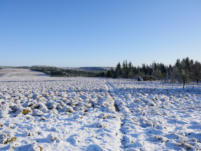
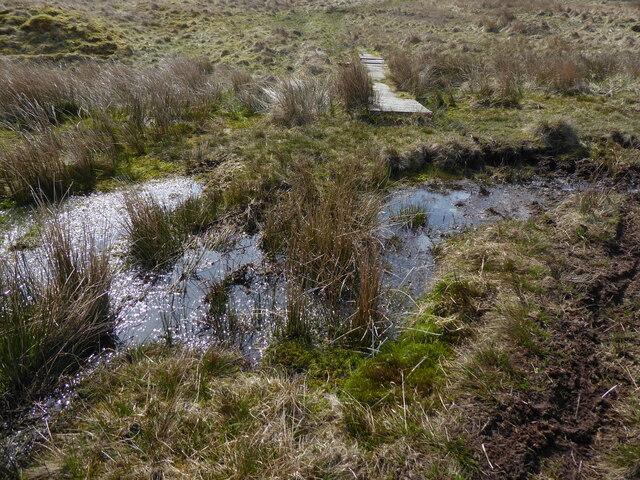
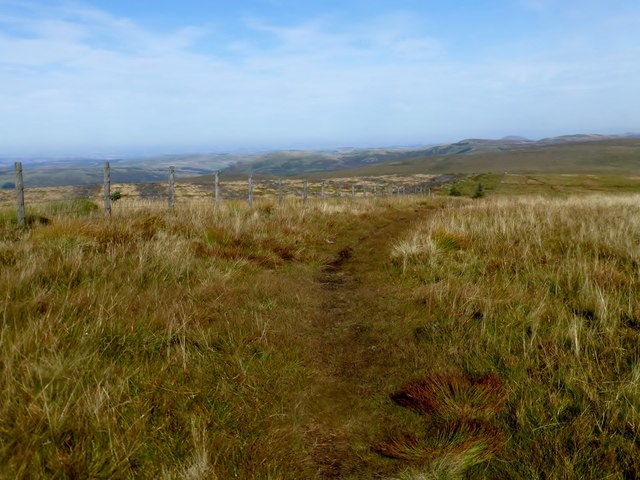
Dun Cleuch is a picturesque valley located in Roxburghshire, a historic county in the Scottish Borders region of Scotland. The valley is situated in the southeastern part of the country, surrounded by stunning natural beauty and rolling hills. It is characterized by its lush greenery, meandering river, and breathtaking landscapes.

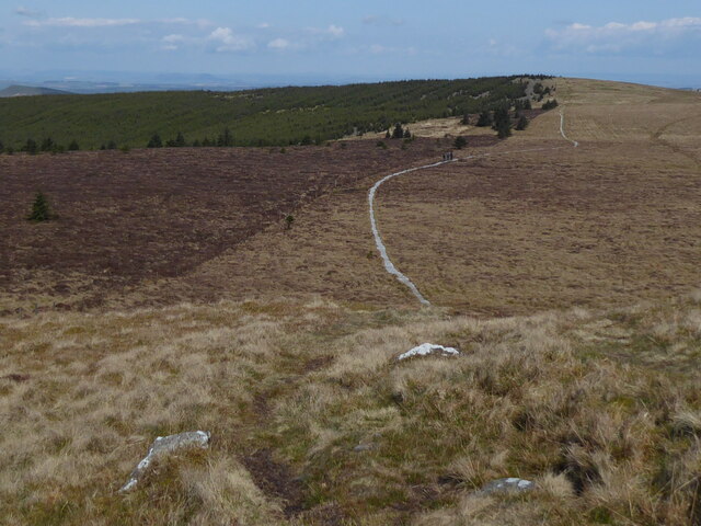
The valley offers a tranquil retreat for nature lovers and outdoor enthusiasts. Its idyllic setting makes it a popular destination for hikers, walkers, and those seeking a peaceful escape from the hustle and bustle of city life. The area is known for its well-maintained hiking trails, which allow visitors to explore the valley's beauty at their own pace.

Dun Cleuch is also home to an abundance of wildlife, including various species of birds, mammals, and plant life. It provides an ideal habitat for many rare and protected species, making it a haven for nature conservationists.

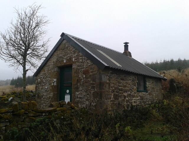
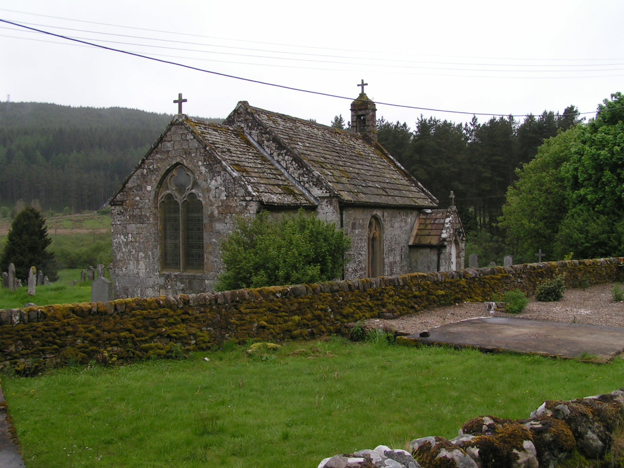
The valley is steeped in history, with several historical landmarks dotting its landscape. From ancient ruins to traditional Scottish architecture, Dun Cleuch offers glimpses into its rich and fascinating past. Visitors can explore historic sites such as castles, old churches, and burial grounds, which add to the valley's charm and cultural significance.

Overall, Dun Cleuch is a hidden gem in Roxburghshire, offering a perfect blend of natural beauty, outdoor activities, and historical attractions. Its serene atmosphere and breathtaking scenery make it a must-visit destination for anyone seeking an authentic Scottish experience.

If you have any feedback on the listing, please let us know in the comments section below.

Dun Cleuch Images

Images are sourced within 2km of 55.355625/-2.3791323 or Grid Reference NT7606. Thanks to Geograph Open Source API. All images are credited.

Forestry near Black Crag Various stages of commercial forestry near Black Crag in the Redesdale Forest.

This photograph was taken during the Coronavirus (COVID-19) pandemic of 2020/21/22.
Forestry near Black Crag
Various stages of commercial forestry near Black Crag in the Redesdale Forest. This photograph was taken during the Coronavirus (COVID-19) pandemic of 2020/21/22.
A junction in the forest A more recent track pushing into the Redesdale Forest along the route of a former firebreak.

This photograph was taken during the Coronavirus (COVID-19) pandemic of 2020/21/22.
A junction in the forest
A more recent track pushing into the Redesdale Forest along the route of a former firebreak. This photograph was taken during the Coronavirus (COVID-19) pandemic of 2020/21/22.
Overlooking Bells Cleugh A shaded cleugh in the forest with a view towards the principal peaks of the Cheviot range.

This photograph was taken during the Coronavirus (COVID-19) pandemic of 2020/21/22.
Overlooking Bells Cleugh
A shaded cleugh in the forest with a view towards the principal peaks of the Cheviot range. This photograph was taken during the Coronavirus (COVID-19) pandemic of 2020/21/22.
The entry to Scotland, The Heart's Toe The fenceline here follows the Scotland/England border.  The Leithope Forest looms large in the distance.

This photograph was taken during the Coronavirus (COVID-19) pandemic of 2020/21/22.
The entry to Scotland, The Heart's Toe
The fenceline here follows the Scotland/England border. The Leithope Forest looms large in the distance. This photograph was taken during the Coronavirus (COVID-19) pandemic of 2020/21/22.
At the forest (and national) boundary Whilst the photographer is just inside England, this view over the fence line mostly takes in grazing moorland of Hawkwillow Fell towards Hungry Law, in Scotland.  This point was reached by a short crossing from the nearby forestry road through the edge of the plantation on Greyhound Law.

This photograph was taken during the Coronavirus (COVID-19) pandemic of 2020/21/22.
At the forest (and national) boundary
Whilst the photographer is just inside England, this view over the fence line mostly takes in grazing moorland of Hawkwillow Fell towards Hungry Law, in Scotland. This point was reached by a short crossing from the nearby forestry road through the edge of the plantation on Greyhound Law. This photograph was taken during the Coronavirus (COVID-19) pandemic of 2020/21/22.
Hungry Law The trig pillar at the 501 metre summit of Hungry Law, only just in Scotland.  Carter Fell can be noted in the distance, left of the trig pillar.

This photograph was taken during the Coronavirus (COVID-19) pandemic of 2020/21/22.
Hungry Law
The trig pillar at the 501 metre summit of Hungry Law, only just in Scotland. Carter Fell can be noted in the distance, left of the trig pillar. This photograph was taken during the Coronavirus (COVID-19) pandemic of 2020/21/22.
Lunch spot on Hungry Law Perhaps not the most sensible of ideas, but a seat on the edge of this trailer looking back towards Greyhound Law resulted in a permafrosted posterior for the remainder of the walk!  The trailer would appear to have been abandoned, perhaps having been used for carrying fencing materials.

This photograph was taken during the Coronavirus (COVID-19) pandemic of 2020/21/22.
Lunch spot on Hungry Law
Perhaps not the most sensible of ideas, but a seat on the edge of this trailer looking back towards Greyhound Law resulted in a permafrosted posterior for the remainder of the walk! The trailer would appear to have been abandoned, perhaps having been used for carrying fencing materials. This photograph was taken during the Coronavirus (COVID-19) pandemic of 2020/21/22.
Grazing moorland on Hungry Law Tussocky grazing moorland on Hungry Law, with a view back to Greyhound Law.

This photograph was taken during the Coronavirus (COVID-19) pandemic of 2020/21/22.
Grazing moorland on Hungry Law
Tussocky grazing moorland on Hungry Law, with a view back to Greyhound Law. This photograph was taken during the Coronavirus (COVID-19) pandemic of 2020/21/22.
Spithope Bothy This small basic hiking shelter is cared for by the Mountain Bothies Association with permission of the landowner. The sign on the door is regarding "Bothy Watch", a police initiative to help prevent misuse of these volunteer maintained facilities.
Spithope Bothy
This small basic hiking shelter is cared for by the Mountain Bothies Association with permission of the landowner. The sign on the door is regarding "Bothy Watch", a police initiative to help prevent misuse of these volunteer maintained facilities.
The Pennine Way near Ravens Pike
The Pennine Way near Ogre Hill
Hungry Law Bagged with Adrian Dust after parking at Carter Bar. Wooplaw Edge, Leap Hill, Hungry Law, Greyhound Law and then Ravens Knowe before heading to the Cottonshope road to walk back to collect Dusty's car from the campsite opposite this road beside the A68.
Name: Hungry Law
Hill number: 3561
Height: 501m / 1644ft
Parent (Ma/M): 2302  The Cheviot
Section: 33: The Scottish Border to the River Tyne
Section: 28B: The River Tweed to the English Border
Area: The Cheviots
Area: The Cheviots
County/UA: Northumberland (CoU)
County/UA: Scottish Borders (UA)
Class: Dewey, Donald Dewey
Grid ref: NT 74719 06139
Summit feature: trig point
Drop: 74m
Col: 427m  NT768070
Hungry Law
Bagged with Adrian Dust after parking at Carter Bar. Wooplaw Edge, Leap Hill, Hungry Law, Greyhound Law and then Ravens Knowe before heading to the Cottonshope road to walk back to collect Dusty's car from the campsite opposite this road beside the A68. Name: Hungry Law Hill number: 3561 Height: 501m / 1644ft Parent (Ma/M): 2302 The Cheviot Section: 33: The Scottish Border to the River Tyne Section: 28B: The River Tweed to the English Border Area: The Cheviots Area: The Cheviots County/UA: Northumberland (CoU) County/UA: Scottish Borders (UA) Class: Dewey, Donald Dewey Grid ref: NT 74719 06139 Summit feature: trig point Drop: 74m Col: 427m NT768070
Greyhound Law Bagged with Adrian Dust after parking at Carter Bar. Wooplaw Edge, Leap Hill, Hungry Law, Greyhound Law and then Ravens Knowe before heading to the Cottonshope road to walk back to collect Dusty's car from the campsite opposite this road beside the A68.
Name: Greyhound Law
Hill number: 15924
Height: 484m / 1588ft
Parent (Ma/M): 2302  The Cheviot
Section: 33: The Scottish Border to the River Tyne
Area: The Cheviots
County/UA: Northumberland (CoU)
Class: Tump (400-499m)
Grid ref: NT761061 (est)
Drop: 33m
Col: 451m  NT755060
Greyhound Law
Bagged with Adrian Dust after parking at Carter Bar. Wooplaw Edge, Leap Hill, Hungry Law, Greyhound Law and then Ravens Knowe before heading to the Cottonshope road to walk back to collect Dusty's car from the campsite opposite this road beside the A68. Name: Greyhound Law Hill number: 15924 Height: 484m / 1588ft Parent (Ma/M): 2302 The Cheviot Section: 33: The Scottish Border to the River Tyne Area: The Cheviots County/UA: Northumberland (CoU) Class: Tump (400-499m) Grid ref: NT761061 (est) Drop: 33m Col: 451m NT755060
Looking Back Towards Fairwood Fell En route between Leap Hill and Hungry Law in the Cheviot Hills.
Looking Back Towards Fairwood Fell
En route between Leap Hill and Hungry Law in the Cheviot Hills.
Looking Back Towards Hungry Law En route between Hungry Law and Greyhound Law in the Cheviot Hills.
Looking Back Towards Hungry Law
En route between Hungry Law and Greyhound Law in the Cheviot Hills.
En Route To Ravens Knowe We used a footpath that kept out of the forest aiming NE to join the Pennine Way on our route between Greyhound Law and Ravens Knowe.
En Route To Ravens Knowe
We used a footpath that kept out of the forest aiming NE to join the Pennine Way on our route between Greyhound Law and Ravens Knowe.
Looking Northwards Along The Pennine Way
Show me another place!

Dun Cleuch is located at Grid Ref: NT7606 (Lat: 55.355625, Lng: -2.3791323)

Unitary Authority: The Scottish Borders

Police Authority: The Lothians and Scottish Borders

What 3 Words

///prop.summer.hindering. Near Rochester, Northumberland

Related Wikis

Chew Green

Chew Green is the site of the ancient Roman encampment, commonly but erroneously called Ad Fines (Latin: The Limits) on the 1885-1900 edition of the Ordnance...

Ramshope

Ramshope is a hamlet and former civil parish, now in the parish of Rochester in Northumberland, England located in Northumberland National Park. It lies...

Byrness

Byrness is a village within Rochester civil parish in Northumberland, England. It is approximately 37 miles (60 km) north-west of Newcastle upon Tyne on...

Featherwood Roman Camps

Featherwood Roman Camps are neighbouring archaeological sites in Northumberland, England, 1 mile (1.6 km) north of Featherwood and about 3 miles (5 km...

Cottonshopeburnfoot

Cottonshopeburnfoot is a hamlet in Redesdale in Northumberland, England. It lies on the A68 road, 2 miles south east of the village of Byrness. The hamlet...

Raid of the Redeswire

The Raid of the Redeswire, also known as the Redeswire Fray, was a border skirmish between England and Scotland on 7 July 1575 which took place at Carter...

Carter Bar

Carter Bar is a pass in the Cheviot Hills, on the Anglo-Scottish border. It lies east of Carter Fell at the head of Redesdale, and is crossed by the A68...

Whitelee Moor

Whitelee Moor is nature reserve of the Northumberland Wildlife Trust, in Northumberland, England, near Carter Bar. A large part of the moor is blanket...

Have you been to Dun Cleuch?

Leave your review of Dun Cleuch below (or comments, questions and feedback).