Mary's Glen

Valley in Roxburghshire

Scotland

Mary's Glen

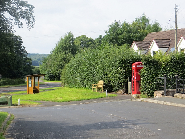
Minor road near Baittens This ection of road also forms part of the route of St Cuthbert's Way, as indicated by the fingerpost on the far side of the road.
Minor road near Baittens Credit: James T M Towill

Mary's Glen is a picturesque valley located in the county of Roxburghshire, Scotland. Situated in the southern part of the country, this glen is known for its stunning natural beauty and rich history.

The valley is named after Mary, Queen of Scots, who is believed to have spent some time in this area during her reign in the 16th century. Mary's Glen is characterized by its rolling hills, dense woodlands, and the meandering River Tweed that flows through it. The landscape is a captivating mix of lush greenery, rocky outcrops, and cascading waterfalls, creating a truly enchanting atmosphere.

The glen is a popular destination for outdoor enthusiasts and nature lovers. There are several walking trails and hiking routes that allow visitors to explore the area's natural wonders. The trails provide breathtaking views of the surrounding countryside, and wildlife sightings are common, including deer, rabbits, and a variety of bird species.

In addition to its natural beauty, Mary's Glen is also home to several historical landmarks. The remains of ancient castles and fortifications can be found scattered throughout the valley, serving as a reminder of its rich past. These historical sites offer a glimpse into the region's fascinating history and are a source of intrigue for history enthusiasts.

Overall, Mary's Glen is a hidden gem in Roxburghshire, offering a unique blend of natural beauty and historical significance. Whether it's for a peaceful walk in nature or a journey through time, this valley has something to offer for everyone.

If you have any feedback on the listing, please let us know in the comments section below.

Mary's Glen Images

Images are sourced within 2km of 55.492061/-2.5105377 or Grid Reference NT6722. Thanks to Geograph Open Source API. All images are credited.

Minor road near Baittens This ection of road also forms part of the route of St Cuthbert's Way, as indicated by the fingerpost on the far side of the road.
Minor road near Baittens
This ection of road also forms part of the route of St Cuthbert's Way, as indicated by the fingerpost on the far side of the road.
Across the fields to Crailing A view towards Crailing in pleasant early June conditions.
Across the fields to Crailing
A view towards Crailing in pleasant early June conditions.
Minor road at Ryecroft and Ryerigg, Jedburgh Looking south-eastward.
Minor road at Ryecroft and Ryerigg, Jedburgh
Looking south-eastward.
Dere Street - former Roman Road - beside Stubcross Plantation Looking north-westward. Walkers, horseriders and farmers continue to make use of this ancient route.
For more detail see : <span class="nowrap"><a title="https://en.wikipedia.org/wiki/Dere_Street#Roman_route" rel="nofollow ugc noopener" href="https://en.wikipedia.org/wiki/Dere_Street#Roman_route">Link</a><img style="margin-left:2px;" alt="External link" title="External link - shift click to open in new window" src="https://s1.geograph.org.uk/img/external.png" width="10" height="10"/></span>
Dere Street - former Roman Road - beside Stubcross Plantation
Looking north-westward. Walkers, horseriders and farmers continue to make use of this ancient route. For more detail see : LinkExternal link
Grazing land hosting sheep and hay bales Looking south-westward.
Grazing land hosting sheep and hay bales
Looking south-westward.
Hedge-lined minor road at Baittens Looking north-eastward.
Hedge-lined minor road at Baittens
Looking north-eastward.
Field edge view at Wester Ulston Triangulation Pillar Looking north-eastward.
Field edge view at Wester Ulston Triangulation Pillar
Looking north-eastward.
Field edge view at Overwells Triangulation Pillar Looking eastward.
Field edge view at Overwells Triangulation Pillar
Looking eastward.
Jedburgh Circular Walk crossing Country Lane near Crouchie Wood Looking westward.
Jedburgh Circular Walk crossing Country Lane near Crouchie Wood
Looking westward.
Crailing countryside Farmland high above the west bank of the Oxnam Water south of Crailing.
Crailing countryside
Farmland high above the west bank of the Oxnam Water south of Crailing.
St Cuthbert's Way near Crailing This section of St Cuthbert's Way leads down and across the Oxnam Water, south of Crailing.
St Cuthbert's Way near Crailing
This section of St Cuthbert's Way leads down and across the Oxnam Water, south of Crailing.
Sandstone cliffs beside the Oxnam Water Towering sandstone cliffs above the west bank of the Oxnam Water, south of Crailing.
Sandstone cliffs beside the Oxnam Water
Towering sandstone cliffs above the west bank of the Oxnam Water, south of Crailing.
Minor road with passing places Looking north along the minor road above the east side of the Jed Water just outside Jedburgh.
Minor road with passing places
Looking north along the minor road above the east side of the Jed Water just outside Jedburgh.
Descending to Littledeanlees A fine view of Teviotdale ahead on the descent to cross the Oxnam Water. This route is on St Cuthbert's Way between Melrose and Holy Island, and also on the circular Jubilee Path.
Descending to Littledeanlees
A fine view of Teviotdale ahead on the descent to cross the Oxnam Water. This route is on St Cuthbert's Way between Melrose and Holy Island, and also on the circular Jubilee Path.
Descent to the Oxnam Water A now redundant gate on the field path to the footbridge.
Descent to the Oxnam Water
A now redundant gate on the field path to the footbridge.
The Oxnam Water A downstream view from the footbridge.
The Oxnam Water
A downstream view from the footbridge.
St Cuthbert's Way above Jedfoot The route meets Dere Street, the Roman Road, to descend to Jedfoot.
St Cuthbert's Way above Jedfoot
The route meets Dere Street, the Roman Road, to descend to Jedfoot.
Routes converging above Jedfoot Two long distance walks, St Cuthbert's Way and the Borders Abbeys Way, the Jubilee Path from Eckford, Crailing and Nisbet, the Jedburgh Circular riding route and two bike routes, the Justice Trail and the Dere Street Dash, all pass by this junction!
Routes converging above Jedfoot
Two long distance walks, St Cuthbert's Way and the Borders Abbeys Way, the Jubilee Path from Eckford, Crailing and Nisbet, the Jedburgh Circular riding route and two bike routes, the Justice Trail and the Dere Street Dash, all pass by this junction!
Show me another place!

Mary's Glen is located at Grid Ref: NT6722 (Lat: 55.492061, Lng: -2.5105377)

Unitary Authority: The Scottish Borders

Police Authority: The Lothians and Scottish Borders

What 3 Words

///songbirds.fruitcake.irritate. Near Jedburgh, Scottish Borders

Related Wikis

Crailing

Crailing is a village on the A698, in Teviotdale, 4m east of Jedburgh in the Scottish Borders area of Scotland, in the historic county of Roxburghshire...

Roxburghshire

Roxburghshire or the County of Roxburgh (Scottish Gaelic: Siorrachd Rosbroig) is a historic county and registration county in the Southern Uplands of Scotland...

Roxburgh, Ettrick and Lauderdale

Roxburgh, Ettrick and Lauderdale (Rosbrog, Eadaraig agus Srath Labhdair in Scottish Gaelic) is a lieutenancy area of Scotland. The lieutenancy area was...

Hartrigge House

Hartrigge House or Stewartfield House was a country house in Jedburgh in the Scottish Borders. Its first owner was in 1614 and it was rebuilt in 1854....

Have you been to Mary's Glen?

Leave your review of Mary's Glen below (or comments, questions and feedback).