Gill Cleugh

Valley in Midlothian

Scotland

Gill Cleugh

Small plantation of trees
Small plantation of trees Credit: Steven Brown

Gill Cleugh, located in Midlothian, Scotland, is a picturesque valley renowned for its natural beauty and rich history. Situated in the heart of the Pentland Hills Regional Park, this hidden gem offers visitors a tranquil escape from the hustle and bustle of city life.

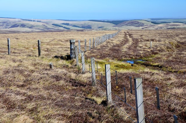
As you enter Gill Cleugh, you are immediately greeted by breathtaking panoramic views of rolling hills, lush greenery, and meandering streams. The valley is home to a diverse range of flora and fauna, making it a haven for nature enthusiasts and wildlife lovers. Walking trails and hiking routes crisscross the area, allowing visitors to explore and immerse themselves in the stunning surroundings.

In addition to its natural allure, Gill Cleugh holds historical significance. The valley was once a major industrial hub, with evidence of old mining activities still visible today. Ruins of former mine buildings and remnants of the railway can be found, serving as reminders of the area's past.

For those seeking outdoor adventures, Gill Cleugh offers various activities such as fishing, birdwatching, and picnicking. Anglers can enjoy the tranquil waters of the nearby reservoirs, which are known for their abundance of trout. Birdwatchers will be delighted by the diverse range of avian species that call this valley home, including buzzards, kestrels, and peregrine falcons.

Gill Cleugh truly captures the essence of Scotland's natural beauty, providing visitors with an idyllic setting to relax, explore, and appreciate the wonders of the great outdoors. Whether you're a nature lover, history buff, or simply in search of some peace and tranquility, this enchanting valley is sure to leave a lasting impression.

If you have any feedback on the listing, please let us know in the comments section below.

Gill Cleugh Images

Images are sourced within 2km of 55.710779/-3.0351241 or Grid Reference NT3546. Thanks to Geograph Open Source API. All images are credited.

Small plantation of trees
B709, Dewar Gill
B709, Dewar Gill
B709 near Dewar
B709 near Dewar
B709 near Dewar
B709 near Dewar
Head of South Grain The start of one of the steep sided glens running down to the Leithen Water. The sheltered ground is planted with conifers, while the going on the moorland is abominable.
Head of South Grain
The start of one of the steep sided glens running down to the Leithen Water. The sheltered ground is planted with conifers, while the going on the moorland is abominable.
Head of South Grain Peat bog and moorland on the Moorfoot Hills, appalling going underfoot.
Head of South Grain
Peat bog and moorland on the Moorfoot Hills, appalling going underfoot.
Moorfoot Hills Hill country near Blackhopebyres. The slopes are well drained, but above is a big area of bog.
Moorfoot Hills
Hill country near Blackhopebyres. The slopes are well drained, but above is a big area of bog.
B709, Moorfoot Hills The road is heading for a distinct pass between the headwaters of the Heriot Water and Leithen Waters. Once through the gap the road widens.
B709, Moorfoot Hills
The road is heading for a distinct pass between the headwaters of the Heriot Water and Leithen Waters. Once through the gap the road widens.
Sheepfold Sheepfold near Dewar passed on the way towards Blackhope Scar.  Most structures today referred to as sheepfolds are ancient dry stone semicircles, with no roof and are one of the oldest types of livestock enclosures.
Sheepfold
Sheepfold near Dewar passed on the way towards Blackhope Scar. Most structures today referred to as sheepfolds are ancient dry stone semicircles, with no roof and are one of the oldest types of livestock enclosures.
Dewar Gill A high pass in the middle of the Moorfoot Hills with the B709 between Heriot and Innerleithen.
Dewar Gill
A high pass in the middle of the Moorfoot Hills with the B709 between Heriot and Innerleithen.
B709, Dewar A long straight road, high in the Moorfoot Hills.
B709, Dewar
A long straight road, high in the Moorfoot Hills.
Dewar Hill Steep heather slopes above the B709.
Dewar Hill
Steep heather slopes above the B709.
B709, Dewar Approaching the pass at Dewar Gill.
B709, Dewar
Approaching the pass at Dewar Gill.
Road through the hills to Innerleithen The narrow pass through which the B709 heads south to the Leithen Water and Innerleithen.
Road through the hills to Innerleithen
The narrow pass through which the B709 heads south to the Leithen Water and Innerleithen.
Gill Cleuch The S arm of the deeply cut cleuch on the steep sides of Eastside Heights. After taking this I spotted a roe deer making its way around the hillside, and later saw several hares on the moorland above.
Gill Cleuch
The S arm of the deeply cut cleuch on the steep sides of Eastside Heights. After taking this I spotted a roe deer making its way around the hillside, and later saw several hares on the moorland above.
Fence junction Fences mark many of the main ridges in these hills.
Fence junction
Fences mark many of the main ridges in these hills.
Summit fence, Eastside Heights The metal strips hung from the fence wires are presumably to make it more visible to low-flying grouse.
Summit fence, Eastside Heights
The metal strips hung from the fence wires are presumably to make it more visible to low-flying grouse.
Boggy area, Eastside Heights A boggy channel in the peaty moorland, nice and colourful but the sort that it's best to detour.
Boggy area, Eastside Heights
A boggy channel in the peaty moorland, nice and colourful but the sort that it's best to detour.
Show me another place!

Gill Cleugh is located at Grid Ref: NT3546 (Lat: 55.710779, Lng: -3.0351241)

Unitary Authority: The Scottish Borders

Police Authority: The Lothians and Scottish Borders

What 3 Words

///often.triathlon.responded. Near Innerleithen, Scottish Borders

Nearby Locations

Gill Cleugh

Related Wikis

Dewar, Scottish Borders

Dewar is a village by the Dewar Burn and Peatrig Hill, in the Scottish Borders area of Scotland. Places nearby include Allanshaugh, Borthwick Hall, Fountainhall...

Peatrig Hill

Peatrig Hill is a minor hill in Scotland, located about 15 km south-southeast of Edinburgh. One of the Moorfoot Hills, it is located in the parish of Heriot...

Blackhope Scar

Blackhope Scar is a hill in the Moorfoot Hills range, part of the Southern Uplands of Scotland. It lies to the northeast of the town of Peebles and is...

Moorfoot Hills

The Moorfoot Hills are a range of hills south of Edinburgh in east central Scotland, one of the ranges which collectively form the Southern Uplands....

Nearby Amenities

Located within 500m of 55.710779,-3.0351241
Bench
Backrest: yes
Lat/Long: 55.7086699/-3.0386132
The data included in this document is from www.openstreetmap.org. The data is made available under ODbL.

Have you been to Gill Cleugh?

Leave your review of Gill Cleugh below (or comments, questions and feedback).