Fauld Cleuch

Valley in Peeblesshire

Scotland

Fauld Cleuch

Leithen Hopes The southern slopes of Whitehope Law in the Moorfoot Hills.
Leithen Hopes Credit: Richard Webb

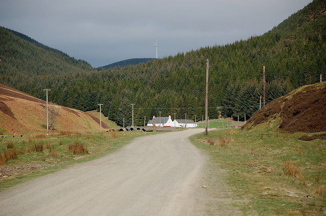
Fauld Cleuch is a picturesque valley located in the region of Peeblesshire, Scotland. Nestled in the Scottish Borders, this idyllic landscape is renowned for its natural beauty and tranquil surroundings. The valley stretches for approximately 5 miles and is flanked by rolling hills and lush greenery, providing a scenic backdrop for visitors and locals alike.

Fauld Cleuch is characterized by its diverse flora and fauna, making it a haven for nature enthusiasts. The valley is home to a variety of plant species, including heather, ferns, and wildflowers, which carpet the hillsides with vibrant colors during the spring and summer months. The surrounding woodlands also offer a haven for wildlife, with sightings of red squirrels, deer, and a wide array of bird species.

The valley is crisscrossed by a network of walking trails, allowing visitors to explore its natural wonders at their own pace. The paths lead through ancient forests, over babbling streams, and up to breathtaking viewpoints, offering panoramic vistas of the surrounding countryside. Additionally, the River Tweed, one of Scotland's most famous salmon rivers, flows through the valley, attracting fishing enthusiasts from far and wide.

Fauld Cleuch is also steeped in history, with remnants of its past visible throughout the landscape. The area is dotted with ancient ruins, such as the remains of old farmsteads and historic landmarks, providing a glimpse into the valley's rich heritage.

Overall, Fauld Cleuch is a hidden gem in Peeblesshire, offering visitors a chance to immerse themselves in the beauty of Scotland's natural landscape and experience a sense of tranquility in this charming valley.

If you have any feedback on the listing, please let us know in the comments section below.

Fauld Cleuch Images

Images are sourced within 2km of 55.697058/-3.0891583 or Grid Reference NT3145. Thanks to Geograph Open Source API. All images are credited.

Leithen Hopes The southern slopes of Whitehope Law in the Moorfoot Hills.
Leithen Hopes
The southern slopes of Whitehope Law in the Moorfoot Hills.
Cairn on summit of Whitehope Law near Innerleithen There are no paths to the summit.
Cairn on summit of Whitehope Law near Innerleithen
There are no paths to the summit.
Descending NE by fence from Whitehope Law near Innerleithen
Road by the Leithen Water The road serves the farms and forestry around the Leithen Water and Wiliamslee Burn. The white cottage is Hunter's Knowe and one of the Bowbeat wind turbines is on the skyline.
Road by the Leithen Water
The road serves the farms and forestry around the Leithen Water and Wiliamslee Burn. The white cottage is Hunter's Knowe and one of the Bowbeat wind turbines is on the skyline.
Track junction at Hunters Knowe The track to the right is not shown on the 1:25,000 map, but it is likely to have been put in before bringing in the wind turbines to Bowbeat. The sign advises that the road is 'liable to icing'.
Track junction at Hunters Knowe
The track to the right is not shown on the 1:25,000 map, but it is likely to have been put in before bringing in the wind turbines to Bowbeat. The sign advises that the road is 'liable to icing'.
Leithen Water at Hunters Knowe The cottage at Hunters Knowe; two pied wagtails were close by.
Leithen Water at Hunters Knowe
The cottage at Hunters Knowe; two pied wagtails were close by.
Clear-felled area, Leithenwater Forest Trees felled here have revealed a view of the Leithen Water and Williamslee to the left. The heather-clad ridge across the valley is Lamb Law.
Clear-felled area, Leithenwater Forest
Trees felled here have revealed a view of the Leithen Water and Williamslee to the left. The heather-clad ridge across the valley is Lamb Law.
Felled area above Williamslee Burn A view down the hillside along the edge of a felled area - most of this valley has been planted and logging is taking place further up the glen.
Felled area above Williamslee Burn
A view down the hillside along the edge of a felled area - most of this valley has been planted and logging is taking place further up the glen.
Upgraded forest road, Williamslee Hope The road surface has been spread with crushed stone and compacted in preparation for logging work.
Upgraded forest road, Williamslee Hope
The road surface has been spread with crushed stone and compacted in preparation for logging work.
Fauld Cleuch Rig A section of clear felled forest on Fauld Cleuch Rig in Williamslee Hope.
Fauld Cleuch Rig
A section of clear felled forest on Fauld Cleuch Rig in Williamslee Hope.
Fauld Cleuch Contrasting sides of the forestry by the small burn in Fauld Cleuch.
Fauld Cleuch
Contrasting sides of the forestry by the small burn in Fauld Cleuch.
Forest road in Williamslee Hope The road climbs at a gentle gradient around the 450m contour on the W side of Williamslee Hope. The distinctive steep col (centre) is Leithen Door, Glentress Forest.
Forest road in Williamslee Hope
The road climbs at a gentle gradient around the 450m contour on the W side of Williamslee Hope. The distinctive steep col (centre) is Leithen Door, Glentress Forest.
Craigie Cleuch Several dry shaly gullies at the head of Craigie Cleuch, at the upper edge of the forestry plantation.
Craigie Cleuch
Several dry shaly gullies at the head of Craigie Cleuch, at the upper edge of the forestry plantation.
Gullies at Craigie Cleuch Several small gullies have formed where the edge of the peaty plateau S of Garvald Punks drops down to Williamslee Hope, a side valley of the Leithen Water. Seen from the track contouring just above the fringe of the forestry plantation.
Gullies at Craigie Cleuch
Several small gullies have formed where the edge of the peaty plateau S of Garvald Punks drops down to Williamslee Hope, a side valley of the Leithen Water. Seen from the track contouring just above the fringe of the forestry plantation.
Moorland and erosion gullies The expanse of almost flat peat moorland S of Blackhope Scar here meets the valley of Williamslee Hope, with several small gullies at the head of Craigie Cleuch.
Moorland and erosion gullies
The expanse of almost flat peat moorland S of Blackhope Scar here meets the valley of Williamslee Hope, with several small gullies at the head of Craigie Cleuch.
Thorter Cleuch The track skirting the forestry plantation in Wlliamslee Hope curves around the re-entrant of Thorter Cleuch.
Thorter Cleuch
The track skirting the forestry plantation in Wlliamslee Hope curves around the re-entrant of Thorter Cleuch.
North Grain North Grain drains the peat moorland of Garvald Punks and flows down through the forestry plantations to join the Williamslee Burn, a tributary of the Leithen Water.
North Grain
North Grain drains the peat moorland of Garvald Punks and flows down through the forestry plantations to join the Williamslee Burn, a tributary of the Leithen Water.
End of the track, Williamslee Hope The end of the track that contours above the edge of the forest, just E of North Grain.
End of the track, Williamslee Hope
The end of the track that contours above the edge of the forest, just E of North Grain.
Show me another place!

Fauld Cleuch is located at Grid Ref: NT3145 (Lat: 55.697058, Lng: -3.0891583)

Unitary Authority: The Scottish Borders

Police Authority: The Lothians and Scottish Borders

What 3 Words

///shut.ruler.meatball. Near Peebles, Scottish Borders

Nearby Locations

Fauld Cleuch Totto Hill

Related Wikis

Bowbeat Hill

Bowbeat Hill is a hill in the Moorfoot Hills range, part of the Southern Uplands of Scotland. It lends its name to Bowbeat Onshore Wind Farm built on the...

Blackhope Scar

Blackhope Scar is a hill in the Moorfoot Hills range, part of the Southern Uplands of Scotland. It lies to the northeast of the town of Peebles and is...

Glentress Forest

Glentress Forest is located near Peebles in the Scottish Borders, about 30 miles south of Edinburgh. Part of the Tweed Valley Forest Park along with Traquair...

Moorfoot Hills

The Moorfoot Hills are a range of hills south of Edinburgh in east central Scotland, one of the ranges which collectively form the Southern Uplands....

Have you been to Fauld Cleuch?

Leave your review of Fauld Cleuch below (or comments, questions and feedback).