Vale of Llangollen

Valley in Denbighshire

Wales

Vale of Llangollen

Old Milestone by the A5, Cwmalis, Vale of Llangollen Telford Plate by the A5, in parish of Llangollen (Denbighshire District), Cwmalis, South side of road.

Inscription reads:-
HOLY-
HEAD
79
LLANGOLLEN
2M-2F
CHIRK-B
4M-5F
Carved benchmark on lower face.

Surveyed

Milestone Society National ID: DEN_HH79
Old Milestone by the A5, Cwmalis, Vale of Llangollen Credit: Richard Thackeray

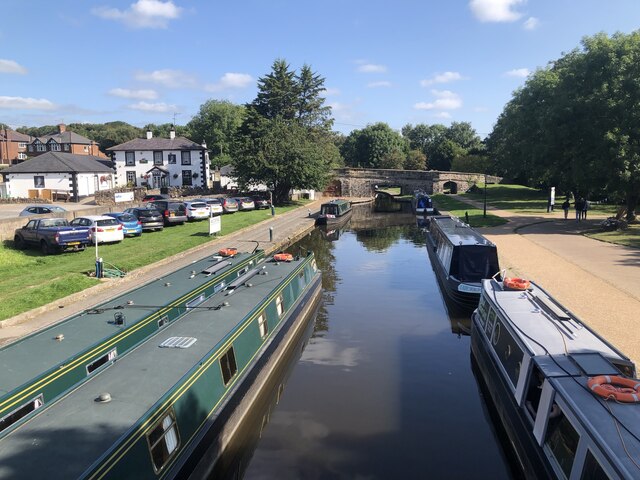
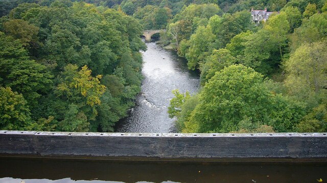
The Vale of Llangollen is a picturesque valley located in Denbighshire, Wales. Situated in the northeastern part of the country, it stretches for approximately 20 miles from the town of Llangollen to the village of Corwen. The valley is carved out by the River Dee, which meanders through the lush green landscape, adding to the area's natural beauty.

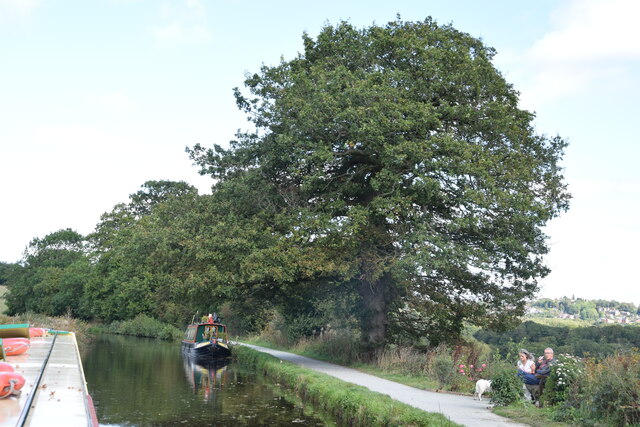
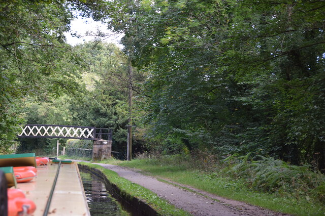
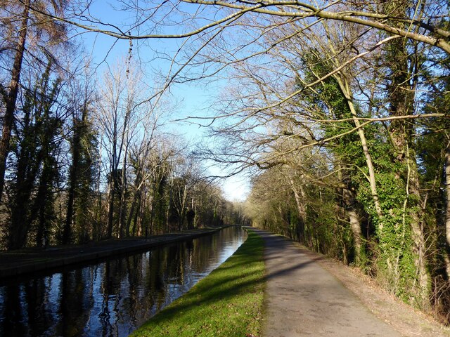
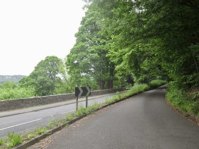
The Vale of Llangollen is renowned for its breathtaking scenery, characterized by rolling hills, dense forests, and charming meadows. The valley is surrounded by the Berwyn Mountains to the west and the Clwydian Range to the east, providing a dramatic backdrop for visitors and residents alike. The landscape is perfect for outdoor activities such as hiking, cycling, and birdwatching, attracting nature enthusiasts from far and wide.

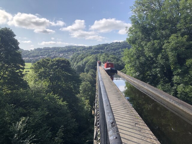
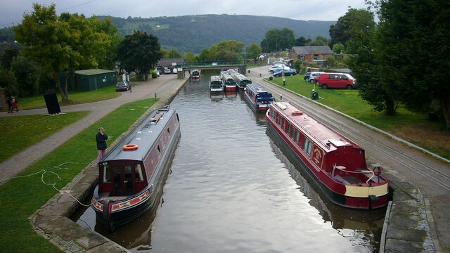
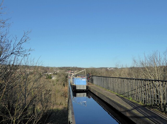
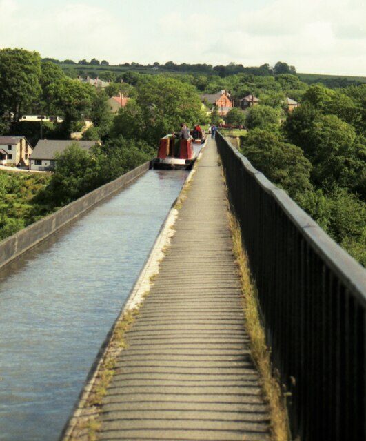
One of the most iconic landmarks in the Vale of Llangollen is the Pontcysyllte Aqueduct, a UNESCO World Heritage site. This impressive feat of engineering was constructed in the early 19th century and carries the Llangollen Canal over the River Dee, offering panoramic views of the valley below.

The town of Llangollen, situated at the southern end of the valley, is a popular tourist destination. It boasts a rich history, with attractions such as the medieval ruins of Castell Dinas Brân and the Plas Newydd historic house and gardens. Llangollen is also famous for hosting the annual International Eisteddfod, a renowned music and arts festival that attracts performers and visitors from across the globe.

In summary, the Vale of Llangollen is a stunning valley in Denbighshire, Wales, offering a blend of natural beauty, outdoor activities, and cultural attractions. Its idyllic scenery and historic landmarks make it a must-visit destination for nature lovers and history enthusiasts alike.

If you have any feedback on the listing, please let us know in the comments section below.

Vale of Llangollen Images

Images are sourced within 2km of 52.967333/-3.1005683 or Grid Reference SJ2641. Thanks to Geograph Open Source API. All images are credited.

Old Milestone by the A5, Cwmalis, Vale of Llangollen Telford Plate by the A5, in parish of Llangollen (Denbighshire District), Cwmalis, South side of road.

Inscription reads:-
HOLY-
HEAD
79
LLANGOLLEN
2M-2F
CHIRK-B
4M-5F
Carved benchmark on lower face.

Surveyed

Milestone Society National ID: DEN_HH79
Old Milestone by the A5, Cwmalis, Vale of Llangollen
Telford Plate by the A5, in parish of Llangollen (Denbighshire District), Cwmalis, South side of road. Inscription reads:- HOLY- HEAD 79 LLANGOLLEN 2M-2F CHIRK-B 4M-5F Carved benchmark on lower face. Surveyed Milestone Society National ID: DEN_HH79
Trevor Basin Trevor Basin is at the northern end of the central section of what was planned as the Ellesmere Canal linking the Mersey and Severn rivers. The canal was never completed in full and Trevor Basin - just north of Pontcysyllte Aqueduct - became the northern terminus. The canal here is today named the Llangollen Canal, though the stretch from Trevor Basin to Llangollen was in fact only originally intended as a water feed to the Ellesmere canal.
Trevor Basin
Trevor Basin is at the northern end of the central section of what was planned as the Ellesmere Canal linking the Mersey and Severn rivers. The canal was never completed in full and Trevor Basin - just north of Pontcysyllte Aqueduct - became the northern terminus. The canal here is today named the Llangollen Canal, though the stretch from Trevor Basin to Llangollen was in fact only originally intended as a water feed to the Ellesmere canal.
Narrowboat on Pontcysyllte Aqueduct The highest canal aqueduct in the world, Grade I listed and a UNESCO World Heritage Site. Completed in 1805 to a design by Thomas Telford and William Jessop.
Narrowboat on Pontcysyllte Aqueduct
The highest canal aqueduct in the world, Grade I listed and a UNESCO World Heritage Site. Completed in 1805 to a design by Thomas Telford and William Jessop.
Llangollen Canal Near Trevor Uchaf.
Llangollen Canal
Near Trevor Uchaf.
Llangollen Canal Bridge 39W Near Bryn-Howel Farm.
Llangollen Canal Bridge 39W
Near Bryn-Howel Farm.
Approaching Bridge 37W On the Llangollen Canal near Llyn Farm.
Approaching Bridge 37W
On the Llangollen Canal near Llyn Farm.
Llangollen Canal near Plas-yn-pentre Taken just east of Bridge 34W.
Llangollen Canal near Plas-yn-pentre
Taken just east of Bridge 34W.
Bridge 33W, Llangollen Canal This bridge just south of the village of Trevor is a footbridge.
Bridge 33W, Llangollen Canal
This bridge just south of the village of Trevor is a footbridge.
Replacing the old reservoir New water storage tanks at Sugn-y-pwl.
Replacing the old reservoir
New water storage tanks at Sugn-y-pwl.
The Duke of Wellington Pub adjacent to the A539.
The Duke of Wellington
Pub adjacent to the A539.
Trevor Arm, Llangollen Canal The Llangollen canal is an arm of the Shropshire Union canal that runs from Hurleston Junction to Llangollen with a wide variety of scenery along its course. Its total length is 46 miles, but the last 1½ miles from Llangollen to Llantisilio is unnavigable by any boats over about 10' length.
The canal's vital statistics for craft are:
Length 72 '
Beam 6'10"
Headroom 7'
Draught 2'3" (Hurleston to Pontcysyllte) 2' (P. to Llangollen)
These are the maximum dimensions for any craft, based on the minimum dimensions of locks & bridges.
There are a total of 21 locks on the canal, but only two between Llangollen and Whitchurch (a distance of about 31 miles). One of the most notable things about the canal is the strong flow especially in the "narrows" near Llangollen and in the tunnels near Chirk. About 12 million gallons of water passes down this canal from the River Dee to the Shropshire Union every day.
The most famous feature of this canal is the superb feat of engineering that is the 200-year-old Pontcysyllte Aqueduct rising 126' above the River Dee and running for over 335 yds - for more information on this see the numerous photos for squares SJ2742 and SJ2741
Trevor Arm, Llangollen Canal
The Llangollen canal is an arm of the Shropshire Union canal that runs from Hurleston Junction to Llangollen with a wide variety of scenery along its course. Its total length is 46 miles, but the last 1½ miles from Llangollen to Llantisilio is unnavigable by any boats over about 10' length. The canal's vital statistics for craft are: Length 72 ' Beam 6'10" Headroom 7' Draught 2'3" (Hurleston to Pontcysyllte) 2' (P. to Llangollen) These are the maximum dimensions for any craft, based on the minimum dimensions of locks & bridges. There are a total of 21 locks on the canal, but only two between Llangollen and Whitchurch (a distance of about 31 miles). One of the most notable things about the canal is the strong flow especially in the "narrows" near Llangollen and in the tunnels near Chirk. About 12 million gallons of water passes down this canal from the River Dee to the Shropshire Union every day. The most famous feature of this canal is the superb feat of engineering that is the 200-year-old Pontcysyllte Aqueduct rising 126' above the River Dee and running for over 335 yds - for more information on this see the numerous photos for squares SJ2742 and SJ2741
Cysylltau Bridge View from Pont Cysyllte Aqueduct.
Cysylltau Bridge
View from Pont Cysyllte Aqueduct.
The Llangollen Canal, Froncysyllte The Llangollen Canal runs on a high tree-covered embankment on the southern approach to Pont-Cysyllte.
The Llangollen Canal, Froncysyllte
The Llangollen Canal runs on a high tree-covered embankment on the southern approach to Pont-Cysyllte.
Repairing the railings Repairs are underway to the cast iron railings of the Pont-Cysyllte aqueduct.  The equipment has been taken to the site by boat and the canal is closed while the work is in progress.
Repairing the railings
Repairs are underway to the cast iron railings of the Pont-Cysyllte aqueduct. The equipment has been taken to the site by boat and the canal is closed while the work is in progress.
Cruising North on the Pontcysyllte Aqueduct in 1995 A convoy system was in use
Cruising North on the Pontcysyllte Aqueduct in 1995
A convoy system was in use
Woodlands Grove, Froncysyllte
A5 West of Froncysyllte.
A5
West of Froncysyllte.
Cwmalis Road, Froncysyllte Leaving the A5 (left).
Cwmalis Road, Froncysyllte
Leaving the A5 (left).
Show me another place!

Vale of Llangollen is located at Grid Ref: SJ2641 (Lat: 52.967333, Lng: -3.1005683)

Unitary Authority: Denbighshire

Police Authority: North Wales

What 3 Words

///novels.bets.ogre. Near Chirk, Wrexham

Related Wikis

Pont Cysyllte

Pont Cysyllte, also known as Cysylltau Bridge or Bont Bridge, is a 17th-century road bridge crossing the River Dee near the village of Trevor, Wrexham...

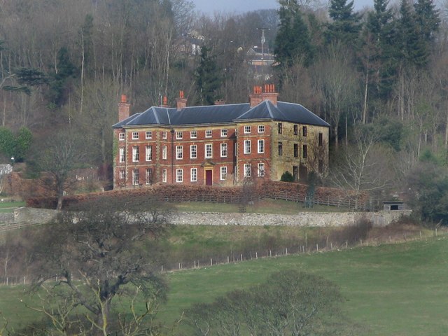
Trevor Hall, Denbighshire

Trevor Hall is a large grade I-listed Georgian mansion standing in 85 acres (35 hectares) of parkland at Trevor, near Llangollen, Denbighshire, Wales....

Pontcysyllte Aqueduct

The Pontcysyllte Aqueduct (Welsh pronunciation: [ˌpɔntkəˈsəɬtɛ]; Welsh: Traphont Ddŵr Pontcysyllte) is a navigable aqueduct that carries the Llangollen...

Trevor railway station

Trevor railway station was formerly a station on the Ruabon to Barmouth Line in north-east Wales. The line was double track between Ruabon and Llangollen...

Nearby Amenities

Located within 500m of 52.967333,-3.1005683
Source: npe
Lat/Long: 52.9695845/-3.0966647
Source: npe
Lat/Long: 52.9684597/-3.0991864
Source: npe
Lat/Long: 52.9666557/-3.1008138
Source: npe
Lat/Long: 52.9650909/-3.1037213
Source: npe
Lat/Long: 52.9641804/-3.1053299
Plas-yn-pentre
Place: hamlet
Lat/Long: 52.964798/-3.0995769
Direction: 185
Generator Method: photovoltaic
Generator Output Electricity: yes
Generator Solar Modules: 8
Generator Source: solar
Generator Type: solar_photovoltaic_panel
Location: roof
Power: generator
Lat/Long: 52.9645456/-3.1012613
Direction: S
Generator Method: photovoltaic
Generator Output Electricity: yes
Generator Solar Modules: 8
Generator Source: solar
Generator Type: solar_photovoltaic_panel
Location: roof
Power: generator
Lat/Long: 52.9645456/-3.1013739
The data included in this document is from www.openstreetmap.org. The data is made available under ODbL.

Have you been to Vale of Llangollen?

Leave your review of Vale of Llangollen below (or comments, questions and feedback).