Dry Cleuch

Valley in Peeblesshire

Scotland

Dry Cleuch

A signpost at Henderland This lichen-covered signpost giving directions to Cockburn’s Grave at Chapelhope is on the north side of the road at Henderland. For more information on Cockburn’s Tomb, see <a href="https://www.geograph.org.uk/photo/1257004">NT2323 : An information plaque at Cockburn's Tomb</a> and <a href="https://www.geograph.org.uk/photo/6429365">NT2323 : Cockburn's Tombe on Chapel Knowe</a>.
A signpost at Henderland Credit: Walter Baxter

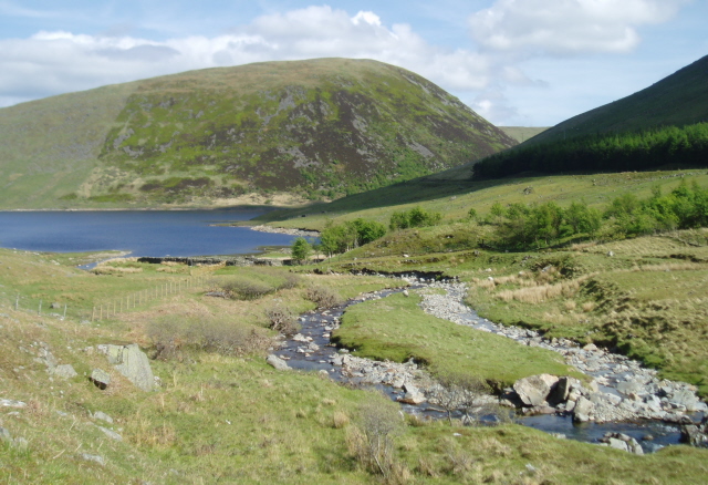
Dry Cleuch is a picturesque valley located in Peeblesshire, a historic county in the Scottish Borders region of Scotland. Situated amidst the breathtaking landscape of the Southern Uplands, the valley is nestled between rolling hills and offers a tranquil escape for nature enthusiasts and outdoor adventurers alike.

The name "Dry Cleuch" is derived from the Scottish Gaelic term "cleuch," which refers to a narrow, steep-sided valley. True to its name, the valley is characterized by its deep and narrow gorges that were formed by the eroding forces of water over thousands of years. These unique geological features make Dry Cleuch a captivating sight to behold.

The valley is adorned with lush vegetation, including ancient oak woodlands, vibrant wildflowers, and moss-covered rocks. Its diverse ecosystem provides a haven for a wide range of wildlife, such as red deer, badgers, and various bird species. Nature enthusiasts can explore the valley through a network of walking trails that wind through the rugged terrain, offering stunning vistas at every turn.

Dry Cleuch is also home to the scenic Dry Cleuch Reservoir, which was constructed in the early 20th century to supply water to the surrounding area. The reservoir adds to the beauty of the valley and provides opportunities for fishing, boating, and birdwatching.

With its captivating natural beauty and peaceful ambiance, Dry Cleuch is a hidden gem in Peeblesshire, offering visitors a chance to immerse themselves in the tranquility of the Scottish countryside.

If you have any feedback on the listing, please let us know in the comments section below.

Dry Cleuch Images

Images are sourced within 2km of 55.504963/-3.2228439 or Grid Reference NT2224. Thanks to Geograph Open Source API. All images are credited.

A signpost at Henderland This lichen-covered signpost giving directions to Cockburn’s Grave at Chapelhope is on the north side of the road at Henderland. For more information on Cockburn’s Tomb, see <a href="https://www.geograph.org.uk/photo/1257004">NT2323 : An information plaque at Cockburn's Tomb</a> and <a href="https://www.geograph.org.uk/photo/6429365">NT2323 : Cockburn's Tombe on Chapel Knowe</a>.
A signpost at Henderland
This lichen-covered signpost giving directions to Cockburn’s Grave at Chapelhope is on the north side of the road at Henderland. For more information on Cockburn’s Tomb, see NT2323 : An information plaque at Cockburn's Tomb and NT2323 : Cockburn's Tombe on Chapel Knowe.
The Megget Water This is an early April view from the south side of the river. Henderland Farm is in the distance.
The Megget Water
This is an early April view from the south side of the river. Henderland Farm is in the distance.
Sheep near Ram Cleuch The hill sheep were on the lower northern slopes of Bridge End Hill.
Sheep near Ram Cleuch
The hill sheep were on the lower northern slopes of Bridge End Hill.
Boulders on the lower northern slopes of Bridge End Hill There are little outcrops and boulders in this area grazed by sheep. Bracken will be a problem in the summer months. The hill in the background is Broomy Law.
Boulders on the lower northern slopes of Bridge End Hill
There are little outcrops and boulders in this area grazed by sheep. Bracken will be a problem in the summer months. The hill in the background is Broomy Law.
How Cleuch This telephoto shot towards How Cleuch on Broomy Law was taken from Syart Rig.
How Cleuch
This telephoto shot towards How Cleuch on Broomy Law was taken from Syart Rig.
A survey pillar at White Knowe The pillar was formed for levelling and surveying purposes in connection with the Megget Reservoir dam. Broomy Law is in the background.
A survey pillar at White Knowe
The pillar was formed for levelling and surveying purposes in connection with the Megget Reservoir dam. Broomy Law is in the background.
Cappercleuch view St Mary's Loch is visible in the background and in the next square.
Cappercleuch view
St Mary's Loch is visible in the background and in the next square.
A frozen pool at Craigie Rig Broomy Law is the hill in the background.
A frozen pool at Craigie Rig
Broomy Law is the hill in the background.
An access track above the Glengaber Burn The steep hill on the right is Broomy Law in winter colours. For the same view in June taken by Jim Barton, see <a href="https://www.geograph.org.uk/photo/6194118">NT2123 : Track in Glen Gaber</a>.
An access track above the Glengaber Burn
The steep hill on the right is Broomy Law in winter colours. For the same view in June taken by Jim Barton, see NT2123 : Track in Glen Gaber.
A commemorative stone at Glenagaber The stone is inscribed as follows:-

2013
SET HERE TO MARK
150 YEARS OF PARTNERSHIP
BETWEEN
THE WEMYSS AND MARCH ESTATES
AND THE MITCHELL FAMILY
TENANTS IN HENDERLAND
SINCE 1863
A commemorative stone at Glenagaber
The stone is inscribed as follows:- 2013 SET HERE TO MARK 150 YEARS OF PARTNERSHIP BETWEEN THE WEMYSS AND MARCH ESTATES AND THE MITCHELL FAMILY TENANTS IN HENDERLAND SINCE 1863
The Glengaber Burn
The Glengaber Burn
Feeding Time Some sheep getting some extra sustenance on a cold February afternoon near Cappercleuch.
Feeding Time
Some sheep getting some extra sustenance on a cold February afternoon near Cappercleuch.
Cappercleuch by St Mary's Loch Cappercleuch is a small settlement on the northwest side of St Mary’s Loch in the Scottish Borders Region. There is a village hall <a href="https://www.geograph.org.uk/photo/726075">NT2423 : Cappercleuch Village Hall</a> and a former 19th century church that has been converted into a dwelling house <a href="https://www.geograph.org.uk/photo/939540">NT2423 : Le Craobhan Treun</a>. The gully in the background is Capper Cleuch between Henderland Bank and Capper Law. This was viewed from Bowerhope Law.
Cappercleuch by St Mary's Loch
Cappercleuch is a small settlement on the northwest side of St Mary’s Loch in the Scottish Borders Region. There is a village hall NT2423 : Cappercleuch Village Hall and a former 19th century church that has been converted into a dwelling house NT2423 : Le Craobhan Treun. The gully in the background is Capper Cleuch between Henderland Bank and Capper Law. This was viewed from Bowerhope Law.
The Megget Water at St Mary's Loch The Megget Water enters the loch at Cappercleuch. Henderland Farm is in the background in this view from Bowerhope Law.
The Megget Water at St Mary's Loch
The Megget Water enters the loch at Cappercleuch. Henderland Farm is in the background in this view from Bowerhope Law.
Cappercleuch AA Box AA Box number 723 just off the A708.
Cappercleuch AA Box
AA Box number 723 just off the A708.
Telephone Exchange The Cappercleuch telephone exchange is in a small compound to the west side of the settlement.
Telephone Exchange
The Cappercleuch telephone exchange is in a small compound to the west side of the settlement.
Road past Megget Dam The minor road from St Mary's Loch to Tweedsmuir on the descent from the reservoir to the valley floor.
Road past Megget Dam
The minor road from St Mary's Loch to Tweedsmuir on the descent from the reservoir to the valley floor.
Glengaber A cottage by the road below the Megget Dam.
Glengaber
A cottage by the road below the Megget Dam.
Show me another place!

Dry Cleuch is located at Grid Ref: NT2224 (Lat: 55.504963, Lng: -3.2228439)

Unitary Authority: The Scottish Borders

Police Authority: The Lothians and Scottish Borders

What 3 Words

///congested.nest.stormed. Near Ettrick, Scottish Borders

Related Wikis

Cappercleuch

Cappercleuch is a settlement on the A708, at St. Mary's Loch in the Scottish Borders area of Scotland, in the historic county of Selkirkshire. Places nearby...

Craigierig

Craigierig is a village on the Megget Reservoir, in the Scottish Borders area of Scotland, in the former Selkirkshire. Places nearby include the Glengaber...

Megget Water

Megget Water is a river in the parish of Yarrow, Selkirkshire in the Scottish Borders area of Scotland. The Water rises at Broad Law (2,760 ft), passes...

St Mary's Loch

St Mary's Loch is the largest natural loch in the Scottish Borders, and is situated on the south side of the A708 road between Selkirk and Moffat, about...

Have you been to Dry Cleuch?

Leave your review of Dry Cleuch below (or comments, questions and feedback).