Thorter Cleuch

Valley in Peeblesshire

Scotland

Thorter Cleuch

The track to Gameshope The track runs alongside the Games Hope Burn.
The track to Gameshope Credit: Gordon Brown

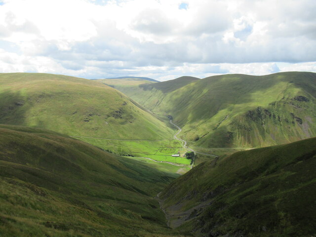
Thorter Cleuch is a picturesque valley located in Peeblesshire, Scotland. Nestled amidst the rolling hills and lush green meadows, this valley is renowned for its stunning natural beauty and tranquil atmosphere.

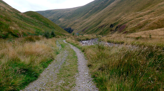
The valley stretches for about 3 miles, with the scenic Thorter Water flowing through it, adding to its charm. The river meanders through the valley, creating small waterfalls and cascades that add to the visual appeal of the area. The soothing sound of the rushing water provides a calming ambience, making Thorter Cleuch a popular spot for nature lovers and those seeking peaceful retreats.

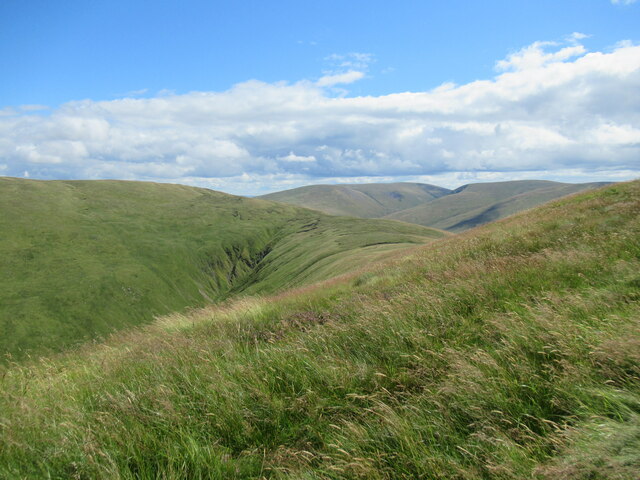
The valley is carpeted with a variety of flora, including heather, wildflowers, and native grasses. This diverse vegetation attracts a wide range of wildlife, making Thorter Cleuch a haven for birdwatchers and nature enthusiasts. Visitors may spot various species of birds, such as the red grouse and peregrine falcon, as well as mammals like the red deer and mountain hare.

Thorter Cleuch also offers a network of well-maintained walking trails that traverse the valley, allowing visitors to explore its beauty up close. These paths cater to different levels of hiking abilities, ranging from gentle strolls to more challenging treks. Along the way, walkers can enjoy breathtaking views of the surrounding hills and the valley itself.

Overall, Thorter Cleuch is a hidden gem within Peeblesshire, offering a peaceful and scenic retreat for those seeking an escape from the hustle and bustle of everyday life. Its natural beauty, diverse wildlife, and well-marked trails make it a must-visit destination for nature lovers and outdoor enthusiasts.

If you have any feedback on the listing, please let us know in the comments section below.

Thorter Cleuch Images

Images are sourced within 2km of 55.483142/-3.3827062 or Grid Reference NT1221. Thanks to Geograph Open Source API. All images are credited.

The track to Gameshope The track runs alongside the Games Hope Burn.
The track to Gameshope
The track runs alongside the Games Hope Burn.
Talla Linfoots viewed down the gully of the Codleteth Burn The Games Hope valley leads off into the hills beyond the farm buildings at Talla Linfoots.
Talla Linfoots viewed down the gully of the Codleteth Burn
The Games Hope valley leads off into the hills beyond the farm buildings at Talla Linfoots.
Talla Cleuch Head A view along the crest of the hill from Codleteth Hill towards the lumpy bulk of Talla Cleuch Head, with a fairly new deer fence (presumably to protect new tree plantings below) on the left. The diagonal bars across the fence are to make it more visible to birds, reducing their chances of flying into the fence.
Talla Cleuch Head
A view along the crest of the hill from Codleteth Hill towards the lumpy bulk of Talla Cleuch Head, with a fairly new deer fence (presumably to protect new tree plantings below) on the left. The diagonal bars across the fence are to make it more visible to birds, reducing their chances of flying into the fence.
Muckle Side and the Talla Reservoir A view from outcrops near from Mathieside Cairn, with Talla Cleuch draining off the hillside into the reservoir, and Garelet Hill prominent on the other side of the reservoir.
Muckle Side and the Talla Reservoir
A view from outcrops near from Mathieside Cairn, with Talla Cleuch draining off the hillside into the reservoir, and Garelet Hill prominent on the other side of the reservoir.
View towards Middle Dodd from below Mathieside Cairn A view across the col between these two rises in the hills above the Talla Reservoir, which is visible on the left.
View towards Middle Dodd from below Mathieside Cairn
A view across the col between these two rises in the hills above the Talla Reservoir, which is visible on the left.
Mathieside Cairn viewed from Talla Cleuch Head A view across the hillsides around the top of Talla Cleuch, a steep ravine draining down into the Talla Reservoir. Some wind turbines are visible at the Glenkerie Wind Farm in the distance.
Mathieside Cairn viewed from Talla Cleuch Head
A view across the hillsides around the top of Talla Cleuch, a steep ravine draining down into the Talla Reservoir. Some wind turbines are visible at the Glenkerie Wind Farm in the distance.
View towards the head of the Hearthstane Burn from Talla Cleuch Head Rolling grassy hills in Tweedsmuir, above the Talla Reservoir.
View towards the head of the Hearthstane Burn from Talla Cleuch Head
Rolling grassy hills in Tweedsmuir, above the Talla Reservoir.
Deer fence on Talla Cleuch Head Some fairly new fencing, presumably to protect new tree plantings somewhere below from hungry deer. The diagonal bars are designed to reduce bird collisions by making the fence more visible.
Deer fence on Talla Cleuch Head
Some fairly new fencing, presumably to protect new tree plantings somewhere below from hungry deer. The diagonal bars are designed to reduce bird collisions by making the fence more visible.
Deer fence and gate near Garelet Hill trig point On the boundary of the Borders Forest Trust land
Deer fence and gate near Garelet Hill trig point
On the boundary of the Borders Forest Trust land
On the summit of Garelet Hill - Trig Point & view to Broad Law This trig point is severely eroded.
On the summit of Garelet Hill - Trig Point & view to Broad Law
This trig point is severely eroded.
Near the summit of Garelet Hill - view to Talla Reservoir Just a couple of hundred yards from the summit of Garelet Hill, this view opens out.
Near the summit of Garelet Hill - view to Talla Reservoir
Just a couple of hundred yards from the summit of Garelet Hill, this view opens out.
Clear felling, Lategillan Rig Broad Law in the background.
Clear felling, Lategillan Rig
Broad Law in the background.
Talla Reservoir and Garelet Hill A day of flat calm. A wet Summer meant that the reservoir was full.
Talla Reservoir and Garelet Hill
A day of flat calm. A wet Summer meant that the reservoir was full.
Talla Reservoir and Garelet Hill The distant moorland is no longer grazed and will become a woodland.
Talla Reservoir and Garelet Hill
The distant moorland is no longer grazed and will become a woodland.
Talla Reservoir and Talla Cleuch Head Recently revealed view from the Silver Jubilee Road on Muckle Knowe.
Talla Reservoir and Talla Cleuch Head
Recently revealed view from the Silver Jubilee Road on Muckle Knowe.
Silver Jubilee Road The logging road loop at the col with Colin Hill and Garelet Hill.  The views over Talla Reservoir stop or start here.
Silver Jubilee Road
The logging road loop at the col with Colin Hill and Garelet Hill. The views over Talla Reservoir stop or start here.
Fence crossing between Garelet Hill & Lairds Cleuch Rig
Talla Reservoir View from the steep road above Talla Linnfoots.
Talla Reservoir
View from the steep road above Talla Linnfoots.
Show me another place!

Thorter Cleuch is located at Grid Ref: NT1221 (Lat: 55.483142, Lng: -3.3827062)

Unitary Authority: The Scottish Borders

Police Authority: The Lothians and Scottish Borders

What 3 Words

///hoaxes.bibs.cotton. Near Ettrick, Scottish Borders

Related Wikis

Talla Reservoir

Talla Reservoir, located a mile from Tweedsmuir, Scottish Borders, Scotland, is an earth-work dam fed by Talla Water. The reservoir is supplemented by...

Talla Water

Talla Water is a river in the Scottish Borders area of Scotland, near Tweedsmuir. It feeds the Talla Reservoir, and is a tributary of the River Tweed....

Victoria Lodge railway station

Victoria Lodge railway station served the village of Tweedsmuir, Scottish Borders, Scotland from 1897 to 1905 on the Symington, Biggar and Broughton Railway...

Broad Law

Broad Law is a hill in the Manor Hills range, part of the Southern Uplands of Scotland. The second-highest point in the Southern Uplands and the highest...

Menzion

Menzion, sometimes Minzion is a small settlement in southern Scotland near Tweedsmuir in the Scottish Borders, in the valley of the River Tweed. ��2...

Tweedsmuir

Tweedsmuir (Scottish Gaelic: Sliabh Thuaidh) is a village and civil parish in Tweeddale, the Scottish Borders Council district, southeastern Scotland....

Fruid Reservoir

Fruid is a small reservoir in the Scottish Borders area of Scotland, UK, near Menzion. It is formed by damming the Fruid Water, and supplements the contents...

Fruid Water

Fruid Water is a river in the Scottish Borders area of Scotland. The valley it occupies has been dammed to form the Fruid Reservoir. The river is a tributary...

Nearby Amenities

Located within 500m of 55.483142,-3.3827062
Mathieside Cairn
Ele: 669
Natural: peak
Lat/Long: 55.4858046/-3.3785567
The data included in this document is from www.openstreetmap.org. The data is made available under ODbL.

Have you been to Thorter Cleuch?

Leave your review of Thorter Cleuch below (or comments, questions and feedback).