The Dingle

Valley in Montgomeryshire

Wales

The Dingle

Dolfor Road near Pen-y-banc Wood
Dolfor Road near Pen-y-banc Wood Credit: Colin Pyle

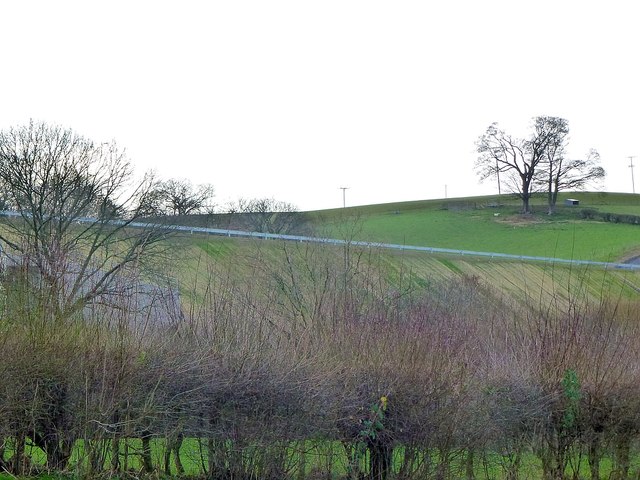
The Dingle, located in Montgomeryshire, is a picturesque valley renowned for its stunning natural beauty and rich history. Situated in the heart of Wales, this tranquil area is a popular destination for nature enthusiasts and history buffs alike.

The Dingle is characterized by its lush greenery, rolling hills, and meandering rivers. The valley is home to a diverse range of flora and fauna, making it a haven for wildlife. Visitors can spot various species of birds, mammals, and plants as they explore the area's numerous walking trails and nature reserves.

In addition to its natural splendor, The Dingle boasts a fascinating history. The valley is dotted with ancient landmarks, including burial mounds and stone circles, dating back to the Neolithic and Bronze Age periods. These archaeological sites provide insights into the region's early human settlements and cultural heritage.

For those seeking a more active experience, The Dingle offers opportunities for outdoor activities such as hiking, cycling, and fishing. The valley is intersected by several rivers, providing ample fishing spots for angling enthusiasts.

The Dingle is also home to a charming village, where visitors can find quaint shops, cafes, and traditional pubs. The village offers a glimpse into rural Welsh life, with its friendly locals and traditional architecture.

In conclusion, The Dingle in Montgomeryshire is a breathtaking valley that showcases the beauty of Wales. With its stunning landscapes, rich history, and abundance of outdoor activities, it is a must-visit destination for nature lovers and history enthusiasts alike.

If you have any feedback on the listing, please let us know in the comments section below.

The Dingle Images

Images are sourced within 2km of 52.500488/-3.316358 or Grid Reference SO1089. Thanks to Geograph Open Source API. All images are credited.

Dolfor Road near Pen-y-banc Wood
Newtown Bypass construction by the Mochdre Industrial Estate
Newtown Bypass construction by the Dolfor Road I think this is a base for the construction team.
Newtown Bypass construction by the Dolfor Road
I think this is a base for the construction team.
Newtown Bypass construction I think this is the entrance to a base for the construction team beside the Dolfor Road. Just across the new road is the Mochdre Industrial Estate and beyond, most of the rest of the town.
Newtown Bypass construction
I think this is the entrance to a base for the construction team beside the Dolfor Road. Just across the new road is the Mochdre Industrial Estate and beyond, most of the rest of the town.
Remains of a tree Removed during Newtown Bypass construction.
Remains of a tree
Removed during Newtown Bypass construction.
Remains of a tree Removed during Newtown Bypass construction.
Remains of a tree
Removed during Newtown Bypass construction.
A steep cutting below Castell-y-dail Wood The horizontal white line is the new bypass.
A steep cutting below Castell-y-dail Wood
The horizontal white line is the new bypass.
The bypass on an embankment As it passes behind Mochdre Industrial Estate.
For a closer view see <a title="https://www.geograph.org.uk/photo/6034940" href="https://www.geograph.org.uk/photo/6034940">Link</a> and <a title="https://www.geograph.org.uk/photo/6034943" href="https://www.geograph.org.uk/photo/6034943">Link</a>.
The bypass on an embankment
As it passes behind Mochdre Industrial Estate. For a closer view see Link and Link.
The bypass on an embankment  As it passes behind Mochdre Industrial Estate.
The bypass on an embankment
As it passes behind Mochdre Industrial Estate.
The bypass on an embankment  As it passes behind Mochdre Industrial Estate.
The bypass on an embankment
As it passes behind Mochdre Industrial Estate.
Looking towards the Newtown Bypass construction Mochdre Industrial Estate (<a href="https://www.geograph.org.uk/gridref/SO0990">SO0990</a>) just right of centre.
Looking towards the Newtown Bypass construction
Mochdre Industrial Estate (SO0990) just right of centre.
Newtown Bypass construction I think this is a base for the construction team beside the Dolfor Road.
Newtown Bypass construction
I think this is a base for the construction team beside the Dolfor Road.
Newtown Bypass construction I think this is a base for the construction team beside the Dolfor Road.
Newtown Bypass construction
I think this is a base for the construction team beside the Dolfor Road.
Last of the snow On the ridge road to Dolfor.
We had heavy snow falls a couple of weeks previously and I'm guessing when this road was cleared a lot was piled up in this wider spot which usually serves as a passing place. Being north facing with a bank and hedge behind it, direct sun did not play any part in shifting it.
Last of the snow
On the ridge road to Dolfor. We had heavy snow falls a couple of weeks previously and I'm guessing when this road was cleared a lot was piled up in this wider spot which usually serves as a passing place. Being north facing with a bank and hedge behind it, direct sun did not play any part in shifting it.
Texel tup On the ridge road to Dolfor.
Texel tup
On the ridge road to Dolfor.
Snow on the mountains Looking west from the ridge road to Dolfor.
Snow on the mountains
Looking west from the ridge road to Dolfor.
Ewe with twin lambs
Ewe with twin lambs
Ewe with twin lambs
Ewe with twin lambs
Show me another place!

The Dingle is located at Grid Ref: SO1089 (Lat: 52.500488, Lng: -3.316358)

Unitary Authority: Powys

Police Authority: Dyfed Powys

What 3 Words

///renting.gives.exploring. Near Newtown, Powys

Nearby Locations

The Dingle

Related Wikis

Newtown High School, Powys

Newtown High School is a secondary comprehensive school for boys and girls. The school is based on two campuses in the towns of Newtown and Presteigne...
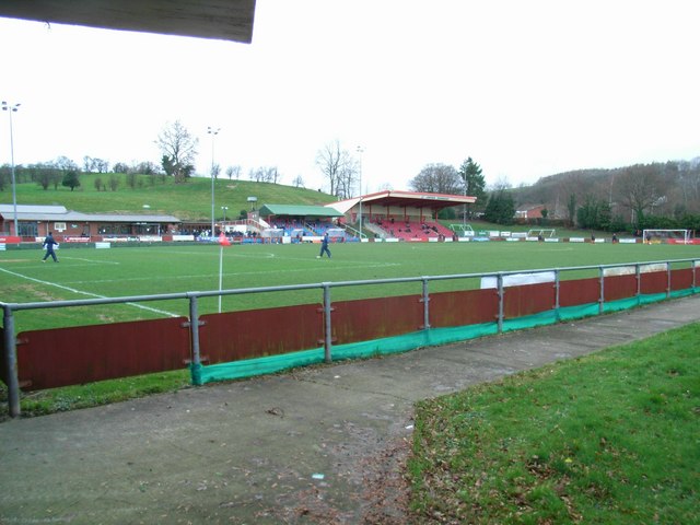
Latham Park

Latham Park is a multi-purpose stadium in Newtown, Wales. It is currently used for football matches and is the home ground of Newtown A.F.C. The stadium...

Newtown Central

Newtown Central was the name of a county electoral ward in the town of Newtown, Powys, Wales. It remains as a community ward to Newtown and Llanllwchaiarn...

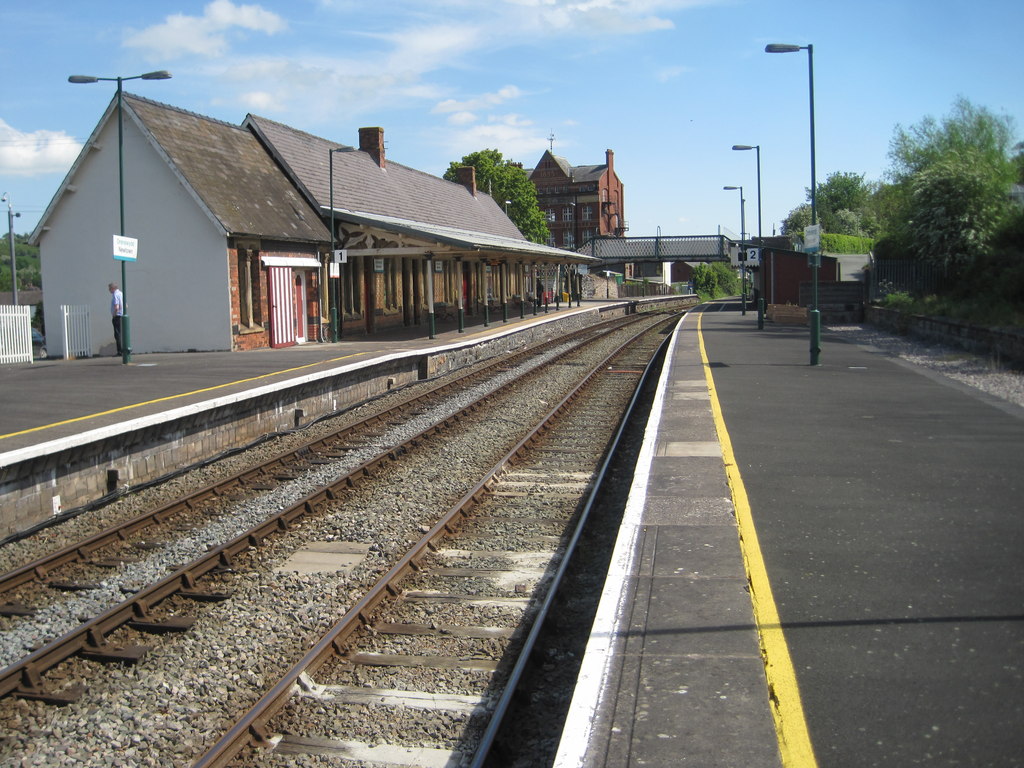
Newtown railway station (Wales)

Newtown railway station (Welsh: Y Drenewydd) is a railway station serving Newtown, Powys, Wales. == History == Newtown was the last major station before...

Nearby Amenities

Located within 500m of 52.500488,-3.316358
Power: pole
Lat/Long: 52.4989371/-3.3166737
Power: pole
Lat/Long: 52.4981631/-3.3191306
Power: pole
Lat/Long: 52.500748/-3.3123192
Power: pole
Lat/Long: 52.4992785/-3.3160367
Power: pole
Lat/Long: 52.5004737/-3.3137676
Power: pole
Lat/Long: 52.4984196/-3.3182093
Power: pole
Lat/Long: 52.5025913/-3.3108158
Power: pole
Lat/Long: 52.49969/-3.3153125
Power: pole
Lat/Long: 52.5000851/-3.3145132
Power: pole
Lat/Long: 52.5010336/-3.310848
Power: pole
Lat/Long: 52.4986972/-3.3172652
Power: pole
Lat/Long: 52.5018467/-3.3108319
Power: pole
Lat/Long: 52.4981551/-3.3214333
Power: pole
Lat/Long: 52.4976961/-3.3207024
Power: pole
Lat/Long: 52.4989683/-3.322753
Place: farm
Lat/Long: 52.499265/-3.3207447
Power: pole
Lat/Long: 52.5045019/-3.3157594
Crossing
Crossing: unmarked
Crossing Island: no
Crossing Markings: no
Tactile Paving: yes
Lat/Long: 52.5038335/-3.3208331
The data included in this document is from www.openstreetmap.org. The data is made available under ODbL.

Have you been to The Dingle?

Leave your review of The Dingle below (or comments, questions and feedback).