Cae'n Coed Dingle

Valley in Montgomeryshire

Wales

Cae'n Coed Dingle

Steeply undulating farmland at Gelli Situated between valleys which drain towards the Severn at Newtown.
Steeply undulating farmland at Gelli Credit: Bill Boaden

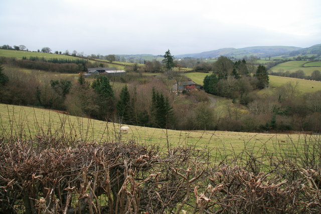
Cae'n Coed Dingle is a small valley located in Montgomeryshire, Wales. It is nestled within the picturesque landscape of the Welsh countryside, surrounded by rolling hills and lush greenery. The valley is known for its tranquil and untouched beauty, offering visitors a serene escape from the hustle and bustle of city life.

The name "Cae'n Coed Dingle" translates to "Field in the Wood Valley," which perfectly encapsulates the valley's characteristic features. The area is abundant in dense woodlands, with a variety of native tree species such as oak, beech, and ash. These trees provide a haven for a diverse range of wildlife, making it a popular destination for nature enthusiasts and birdwatchers.

The valley is also home to a babbling brook, which meanders through the landscape, adding to the valley's peaceful ambiance. The sound of running water creates a soothing backdrop, enhancing the overall tranquility of the area.

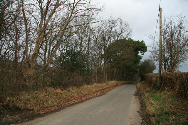
Visitors to Cae'n Coed Dingle can enjoy leisurely walks along the numerous footpaths that crisscross the valley. These paths lead through the woodlands and offer breathtaking views of the surrounding countryside. The valley is particularly enchanting during the spring and summer months when wildflowers carpet the meadows, painting the landscape with vibrant colors.

Cae'n Coed Dingle is a hidden gem in Montgomeryshire, offering visitors a chance to immerse themselves in the natural beauty of the Welsh countryside. Whether it is a peaceful stroll, birdwatching, or simply enjoying the serenity of the surroundings, this valley is a must-visit destination for nature lovers.

If you have any feedback on the listing, please let us know in the comments section below.

Cae'n Coed Dingle Images

Images are sourced within 2km of 52.475852/-3.3680978 or Grid Reference SO0787. Thanks to Geograph Open Source API. All images are credited.

Steeply undulating farmland at Gelli Situated between valleys which drain towards the Severn at Newtown.
Steeply undulating farmland at Gelli
Situated between valleys which drain towards the Severn at Newtown.
Dolau Inn, Mochdre Viewed from behind and further up the hill, with Llyfnant Brook running between.
Dolau Inn, Mochdre
Viewed from behind and further up the hill, with Llyfnant Brook running between.
A483 bend near Bryn-bedwen
Damaged Milestone
Damaged Milestone
Old Milestone by the A483, west of Little Bryn-Bedwen, Kerry Parish By the A483, in parish of Kerry (Powys District), Little Brynbedwen, South of Glascoed, in hedge.

Inscription reads:- : NEWTOWN / 3 MILES / BUILTH 32 :

Surveyed

Milestone Society National ID: MOT_NTBU03
Old Milestone by the A483, west of Little Bryn-Bedwen, Kerry Parish
By the A483, in parish of Kerry (Powys District), Little Brynbedwen, South of Glascoed, in hedge. Inscription reads:- : NEWTOWN / 3 MILES / BUILTH 32 : Surveyed Milestone Society National ID: MOT_NTBU03
Lon Wledig uwchben Stepaside / Country Lane above Stepaside Lon wledig gyda grychoedd a bob ochr ger Stepaside. Hefyd rhan o Lwybyr Biecio Sustrans 81 / Country lane with hedges on both sides near Stepaside. Also part of Sustrans Cycle Route 81
Lon Wledig uwchben Stepaside / Country Lane above Stepaside
Lon wledig gyda grychoedd a bob ochr ger Stepaside. Hefyd rhan o Lwybyr Biecio Sustrans 81 / Country lane with hedges on both sides near Stepaside. Also part of Sustrans Cycle Route 81
Sheep pasture at Cwm Graig Sheltered sheep pastures and farm at Cwm Graig, just below the A483 near Glascoed.
Sheep pasture at Cwm Graig
Sheltered sheep pastures and farm at Cwm Graig, just below the A483 near Glascoed.
Native woodland Native deciduous woodland at Glog Wood, on the lower, north-western slopes of The Glog, beside the narrow (no passing places) lane that connects with the A483 near Bwlch Gate.
Native woodland
Native deciduous woodland at Glog Wood, on the lower, north-western slopes of The Glog, beside the narrow (no passing places) lane that connects with the A483 near Bwlch Gate.
Sheep pasture Taken over newly trimmed hedges, this view of sheep pastures looks over to Pen-y-Bryn on the right and Old Neuadd on the left.  The picture is taken from the lane that runs below Glog Wood.
Sheep pasture
Taken over newly trimmed hedges, this view of sheep pastures looks over to Pen-y-Bryn on the right and Old Neuadd on the left. The picture is taken from the lane that runs below Glog Wood.
Lane near Llwyn-Madoc This worn out old lane climbs westwards at around 1:5 to 1:6 passing the farm at Llwyn-Madoc and heading in the rough direction of Pentre. The road surface shows the effects of constant water flows and weathering, while the photo is taken from a point on the road which periodically needs to be forded.
Lane near Llwyn-Madoc
This worn out old lane climbs westwards at around 1:5 to 1:6 passing the farm at Llwyn-Madoc and heading in the rough direction of Pentre. The road surface shows the effects of constant water flows and weathering, while the photo is taken from a point on the road which periodically needs to be forded.
Chapel, Pentre This is the little Baptist Chapel in the village of Pentre in the parish of Mochdre.  Photo taken from the older graveyard on the north-eastern side of the chapel.
Chapel, Pentre
This is the little Baptist Chapel in the village of Pentre in the parish of Mochdre. Photo taken from the older graveyard on the north-eastern side of the chapel.
Pentre Baptist Chapel The little Baptist Chapel at Pentre, taken from the modern graveyard on the south side of the chapel.  The much older original graveyard lies on the far side of the building.
Pentre Baptist Chapel
The little Baptist Chapel at Pentre, taken from the modern graveyard on the south side of the chapel. The much older original graveyard lies on the far side of the building.
Lane beside Cae'n Coed Dingle This quiet country lane running towards Mochdre lies on the eastern side of the mixed woodland that forms Cae'n Coed Dingle and at this point stands at about 250m.
Lane beside Cae'n Coed Dingle
This quiet country lane running towards Mochdre lies on the eastern side of the mixed woodland that forms Cae'n Coed Dingle and at this point stands at about 250m.
Ford on the Mochdre Brook The little lane running from Pentre to Mochdre crosses the Mochdre Brook at this picturesque ford situated at the foot of two steep descents.
Ford on the Mochdre Brook
The little lane running from Pentre to Mochdre crosses the Mochdre Brook at this picturesque ford situated at the foot of two steep descents.
Lane at Hendre A section of the narrow country lane that runs, between recently trimmed hedges, from just opposite the farm at Hendre to link various farms in a long loop to the south-west of Mochdre.
Lane at Hendre
A section of the narrow country lane that runs, between recently trimmed hedges, from just opposite the farm at Hendre to link various farms in a long loop to the south-west of Mochdre.
Bridge in Hafod Dingle This small and rather battered road bridge crosses the Dunant stream in Hafod Dingle, south-west of Mochdre.
Bridge in Hafod Dingle
This small and rather battered road bridge crosses the Dunant stream in Hafod Dingle, south-west of Mochdre.
Nant Dunant - Dunant stream Taken beside the OS 354m mark on the 1:25,000 map, this is the Dunant stream flowing roughly NNE from near the summit of Yr Allt.  The stream passes through Hafod Dingle and eventually forms part of the Mochdre Brook.
Nant Dunant - Dunant stream
Taken beside the OS 354m mark on the 1:25,000 map, this is the Dunant stream flowing roughly NNE from near the summit of Yr Allt. The stream passes through Hafod Dingle and eventually forms part of the Mochdre Brook.
Pastures at Cwmbyr These sheep pastures sit at around the 400m mark and belong to the farm at Cwmbyr.  A solitary sheep wonders where to start next...
Pastures at Cwmbyr
These sheep pastures sit at around the 400m mark and belong to the farm at Cwmbyr. A solitary sheep wonders where to start next...
Show me another place!

Cae'n Coed Dingle is located at Grid Ref: SO0787 (Lat: 52.475852, Lng: -3.3680978)

Unitary Authority: Powys

Police Authority: Dyfed Powys

What 3 Words

///lifts.saturate.calculating. Near Mochdre, Powys

Related Wikis

Mochdre, Powys

Mochdre () is a small village in the community of Mochdre with Penstrowed, in Montgomeryshire, Powys, Wales. == Geography == About 3 miles (4.8 km) southwest...

Mochdre with Penstrowed

Mochdre with Penstrowed (Welsh: Mochdre gyda Phenystrywaid), or just Mochdre, is a community in Montgomeryshire, Powys, Wales. The community includes Mochdre...

Dolfor

Dolfor is a small hamlet in the north of Powys, Wales. It is located about three miles to the south of Newtown, at the junction of the B4355 and A483 roads...

Scafell Halt railway station

Scafell Halt was a railway station on the Cambrian Line, located to the west of Newtown, Powys, Wales; it was adjacent to Scafell Bridge on the River Severn...

Penstrowed

Penstrowed is a historic Montgomeryshire parish to the west of Newtown, now in the community of Mochdre with Penstrowed, Powys, Wales . == Description... ==

Mid Wales

Mid Wales (Welsh: Canolbarth Cymru or simply Y Canolbarth, meaning "the midlands") or Central Wales is a region of Wales, encompassing its midlands, in...

Newtown Central

Newtown Central was the name of a county electoral ward in the town of Newtown, Powys, Wales. It remains as a community ward to Newtown and Llanllwchaiarn...

Penystrywad

Penystrywad is a village near Llandinam in Powys, central Wales, between Newtown and Llanidloes, located on the A470.

Nearby Amenities

Located within 500m of 52.475852,-3.3680978
Building: yes
Lat/Long: 52.4740073/-3.3626944
Building: yes
Lat/Long: 52.4800888/-3.3664675
Building: yes
Lat/Long: 52.4787688/-3.364472
Power: pole
Lat/Long: 52.4801213/-3.3670688
Power: pole
Lat/Long: 52.4797456/-3.3673129
Power: pole
Lat/Long: 52.4794401/-3.3675033
Power: pole
Lat/Long: 52.478393/-3.367329
Power: pole
Lat/Long: 52.4780679/-3.3672485
Power: pole
Lat/Long: 52.4776186/-3.3672137
Power: pole
Lat/Long: 52.4772053/-3.3671412
Power: pole
Lat/Long: 52.4765208/-3.3670044
Power: pole
Lat/Long: 52.4756533/-3.3671198
Power: pole
Lat/Long: 52.4747498/-3.3672217
Power: pole
Lat/Long: 52.4743104/-3.3672002
Power: pole
Lat/Long: 52.4736307/-3.3671305
Power: pole
Lat/Long: 52.4730981/-3.3670018
Power: pole
Lat/Long: 52.4723138/-3.3677984
Power: pole
Lat/Long: 52.4717453/-3.3681471
Direction: 145
Fixme: much older pattern, never sure if PV or solar
Generator Method: photovoltaic
Generator Output Electricity: yes
Generator Solar Modules: 8
Generator Source: solar
Generator Type: solar_photovoltaic_panel
Location: roof
Power: generator
Lat/Long: 52.4766037/-3.3724487
Direction: 175
Generator Method: photovoltaic
Generator Output Electricity: yes
Generator Solar Modules: 16
Generator Source: solar
Generator Type: solar_photovoltaic_panel
Location: roof
Power: generator
Lat/Long: 52.4727251/-3.3674973
The data included in this document is from www.openstreetmap.org. The data is made available under ODbL.

Have you been to Cae'n Coed Dingle?

Leave your review of Cae'n Coed Dingle below (or comments, questions and feedback).