Ferny Cleuch

Valley in Peeblesshire

Scotland

Ferny Cleuch

Scottish Borders : The A701 Heading along the A701 through the Scottish Borders.
Scottish Borders : The A701 Credit: Lewis Clarke

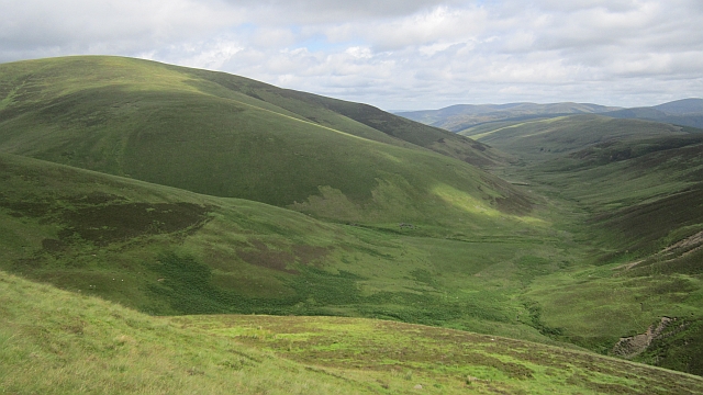
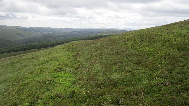
Ferny Cleuch is a picturesque valley located in the region of Peeblesshire, Scotland. Nestled amidst the rolling hills and lush greenery, this valley offers a tranquil and scenic retreat for nature lovers and outdoor enthusiasts.

The valley is known for its stunning natural beauty, characterized by its meandering river, dense woodlands, and majestic mountains that surround it. The River Tweed flows through the heart of Ferny Cleuch, adding to its charm and providing a habitat for various species of wildlife.

Hiking and walking trails crisscross the valley, allowing visitors to explore its enchanting landscapes. The trails cater to all levels of fitness, from gentle strolls along the riverbank to more challenging treks up the nearby hills. Along the way, hikers are treated to breathtaking views of the valley, with its cascading waterfalls, colorful wildflowers, and ancient rock formations.

Ferny Cleuch is also a haven for birdwatchers, as it is home to a diverse range of bird species. Red kites, buzzards, and owls can often be spotted soaring above the treetops, while the riverside offers opportunities to see water birds such as herons and kingfishers.

For those seeking a peaceful and secluded getaway, Ferny Cleuch offers a handful of charming cottages and guesthouses. These accommodations provide a cozy base from which to explore the valley and its surrounding attractions, including nearby historic sites and quaint villages.

In conclusion, Ferny Cleuch is a hidden gem in Peeblesshire, offering natural beauty, outdoor activities, and a peaceful ambiance for visitors to enjoy.

If you have any feedback on the listing, please let us know in the comments section below.

Ferny Cleuch Images

Images are sourced within 2km of 55.483669/-3.5106851 or Grid Reference NT0422. Thanks to Geograph Open Source API. All images are credited.

Scottish Borders : The A701 Heading along the A701 through the Scottish Borders.
Scottish Borders : The A701
Heading along the A701 through the Scottish Borders.
Scottish Borders : The A701 Heading along the A701 through the Scottish Borders.
Scottish Borders : The A701
Heading along the A701 through the Scottish Borders.
Kame and wind turbines by the Hilshie Burn The mound in the middle ground looks like a kame - a mound of material deposited on the ground during glacial retreat.
Kame and wind turbines by the Hilshie Burn
The mound in the middle ground looks like a kame - a mound of material deposited on the ground during glacial retreat.
Upper Tweeddale Meadowsweet beside the upper Tweed, not far from its source. Much of the land here is forested.
Upper Tweeddale
Meadowsweet beside the upper Tweed, not far from its source. Much of the land here is forested.
River Tweed near to Glenbreck The River Tweed is 97 miles long and flows generally west to east through the Scottish borders. It rises at Tweedsmuir and passes through small towns like Peebles, Selkirk, Melrose, Galashields and Kelso, before entering the North Sea at Berwick on Tweed.
River Tweed near to Glenbreck
The River Tweed is 97 miles long and flows generally west to east through the Scottish borders. It rises at Tweedsmuir and passes through small towns like Peebles, Selkirk, Melrose, Galashields and Kelso, before entering the North Sea at Berwick on Tweed.
A701 south of Glenbreck At one time, the A701 was the major road between Edinburgh and Dumfries. The southern section between Dumfries and Beattock is still a trunk road, forming the primary route link between Dumfries and the A74(M) for northbound Glasgow/Edinburgh traffic. The northern section has now been largely downgraded in favour of the A74M/A702 route to Edinburgh but is popular with some (particularly motorcyclists) as an alternative to the A7 or A702 routes and it is signposted as a scenic route to Edinburgh from the motorway.
A701 south of Glenbreck
At one time, the A701 was the major road between Edinburgh and Dumfries. The southern section between Dumfries and Beattock is still a trunk road, forming the primary route link between Dumfries and the A74(M) for northbound Glasgow/Edinburgh traffic. The northern section has now been largely downgraded in favour of the A74M/A702 route to Edinburgh but is popular with some (particularly motorcyclists) as an alternative to the A7 or A702 routes and it is signposted as a scenic route to Edinburgh from the motorway.
A701 at Glenbreck At one time, the A701 was the major road between Edinburgh and Dumfries. The southern section between Dumfries and Beattock is still a trunk road, forming the primary route link between Dumfries and the A74(M) for northbound Glasgow/Edinburgh traffic. The northern section has now been largely downgraded in favour of the A74M/A702 route to Edinburgh but is popular with some (particularly motorcyclists) as an alternative to the A7 or A702 routes and it is signposted as a scenic route to Edinburgh from the motorway.
A701 at Glenbreck
At one time, the A701 was the major road between Edinburgh and Dumfries. The southern section between Dumfries and Beattock is still a trunk road, forming the primary route link between Dumfries and the A74(M) for northbound Glasgow/Edinburgh traffic. The northern section has now been largely downgraded in favour of the A74M/A702 route to Edinburgh but is popular with some (particularly motorcyclists) as an alternative to the A7 or A702 routes and it is signposted as a scenic route to Edinburgh from the motorway.
View to the west from Coomb Dod A view of moorland and wind turbines
View to the west from Coomb Dod
A view of moorland and wind turbines
Sheepfold near Hilshie Burn
Mound beside Hilshie Burn
Valley towards Wills Cleuch Head
Hillside near Slate Brae
Wall above forest on Whitecamp Brae
Hillside towards Low Goat Syke on Great Hill
Fence between Wills Cleuch Head and Risingclaw Heights
Glenwhappen Dod The not forested side of Glenwhappen Dod at the head of the Kingledoors Glen.
Glenwhappen Dod
The not forested side of Glenwhappen Dod at the head of the Kingledoors Glen.
Kingledoors Looking down the glen from the slopes of Coomb Dod. The hill is Gathersnow Hill.
Kingledoors
Looking down the glen from the slopes of Coomb Dod. The hill is Gathersnow Hill.
Lost road on Coomb Dod Feelings of disgust at the horrid roads built on the hill can be softened. This probably dates to the forestry around 1980 and was never used. It is now reclaimed by the moorland vegetation: there is hope! It continues to the col between Coomb Dod and Hillshaw Head.

I would hazard a guess it was intended for a greater forested area than was actually planted.
Lost road on Coomb Dod
Feelings of disgust at the horrid roads built on the hill can be softened. This probably dates to the forestry around 1980 and was never used. It is now reclaimed by the moorland vegetation: there is hope! It continues to the col between Coomb Dod and Hillshaw Head. I would hazard a guess it was intended for a greater forested area than was actually planted.
Show me another place!

Ferny Cleuch is located at Grid Ref: NT0422 (Lat: 55.483669, Lng: -3.5106851)

Unitary Authority: The Scottish Borders

Police Authority: The Lothians and Scottish Borders

What 3 Words

///digests.treatment.failed. Near Biggar, South Lanarkshire

Related Wikis

Hawkshaw, Scottish Borders

Hawkshaw is a pair of semi-detached houses on the River Tweed, two miles southwest of Tweedsmuir in the Scottish Borders. Historically part of Peeblesshire...

Gathersnow Hill

Gathersnow Hill is a hill in the Culter Hills range, part of the Southern Uplands of Scotland. It lies west of the village of Tweedsmuir on the border...

Fruid Water

Fruid Water is a river in the Scottish Borders area of Scotland. The valley it occupies has been dammed to form the Fruid Reservoir. The river is a tributary...

Menzion

Menzion, sometimes Minzion is a small settlement in southern Scotland near Tweedsmuir in the Scottish Borders, in the valley of the River Tweed. ��2...

Tweedsmuir

Tweedsmuir (Scottish Gaelic: Sliabh Thuaidh) is a village and civil parish in Tweeddale, the Scottish Borders Council district, southeastern Scotland....

Fruid Reservoir

Fruid is a small reservoir in the Scottish Borders area of Scotland, UK, near Menzion. It is formed by damming the Fruid Water, and supplements the contents...

Oliver Castle

Oliver Castle was a medieval tower house, located in upper Tweedsdale in the Scottish Borders. The site of the hillfort known as Oliver Castle is to the...

Victoria Lodge railway station

Victoria Lodge railway station served the village of Tweedsmuir, Scottish Borders, Scotland from 1897 to 1905 on the Symington, Biggar and Broughton Railway...

Have you been to Ferny Cleuch?

Leave your review of Ferny Cleuch below (or comments, questions and feedback).