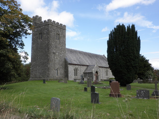
Nant yr Esgob

Valley in Brecknockshire

Wales

Nant yr Esgob

B4358 near Pentre-Lleyn-Llwyd
B4358 near Pentre-Lleyn-Llwyd Credit: Steven Brown

The requested URL returned error: 429 Too Many Requests

If you have any feedback on the listing, please let us know in the comments section below.

Nant yr Esgob Images

Images are sourced within 2km of 52.18199/-3.526768 or Grid Reference SN9554. Thanks to Geograph Open Source API. All images are credited.

B4358 near Pentre-Lleyn-Llwyd
Road junction near Llanafan-Fawr
Fields by Fronwen A peaceful scene in falling evening light, marred slightly by unsightly forest clearance.
Fields by Fronwen
A peaceful scene in falling evening light, marred slightly by unsightly forest clearance.
Farmland near Brongarth Undulating pastures surrounded by hills, with a distant view to Bwlchciliau.
Farmland near Brongarth
Undulating pastures surrounded by hills, with a distant view to Bwlchciliau.
Powys farmland Mostly given over to grassland for rearing livestock.
Powys farmland
Mostly given over to grassland for rearing livestock.
Rough pasture near Bryn Llwyd Farm
Feeding time Giving the lambs a boost in the early evening at Gwern-y-mynach. Dry weather has meant that grass is not growing as it should.
Feeding time
Giving the lambs a boost in the early evening at Gwern-y-mynach. Dry weather has meant that grass is not growing as it should.
Rock outcrop Rock outcrops are rare in the upland pasture, but here we see a prominent, sandy unit of the Yr Allt Formation, of Ordovician (Ashgill) age. Because of the dry weather in recent weeks, grass has already started to die back where soil is thin over the buried rock.
Rock outcrop
Rock outcrops are rare in the upland pasture, but here we see a prominent, sandy unit of the Yr Allt Formation, of Ordovician (Ashgill) age. Because of the dry weather in recent weeks, grass has already started to die back where soil is thin over the buried rock.
Local summit A grass-covered summit in a well-tended pasture which makes a strong contrast with the bracken-covered hills on the opposite side of Cwm Chwefri. At this time of year, before new growth dominates, the dead bracken has an attractive pink-brown hue.
Local summit
A grass-covered summit in a well-tended pasture which makes a strong contrast with the bracken-covered hills on the opposite side of Cwm Chwefri. At this time of year, before new growth dominates, the dead bracken has an attractive pink-brown hue.
Small quarry Small, informal quarries provide a local source of hardcore for use on the surrounding farms. Here a working displays the fine, straight cleavage of the Ordovician (Ashgill) Yr Allt Formation, a silty or muddy rock with few beds of sandstone. The orientation of the bedding in this outcrop is obscure.
Small quarry
Small, informal quarries provide a local source of hardcore for use on the surrounding farms. Here a working displays the fine, straight cleavage of the Ordovician (Ashgill) Yr Allt Formation, a silty or muddy rock with few beds of sandstone. The orientation of the bedding in this outcrop is obscure.
Cwm Trychan A barn and lambing-shed at the head of the cwm together with the cleared remains of the earlier farm buildings.
Cwm Trychan
A barn and lambing-shed at the head of the cwm together with the cleared remains of the earlier farm buildings.
Quarried hillside Another informal quarry for farm use, simply excavated into the steep hillside on the east of the cwm. This is another exposure of the Ordovician (Ashgill) Yr Allt Formation, which is a thick and extensive sequence of mudstones and siltstones. The dominant feature here is a chaotic cleavage, first imposed by the Caledonian mountain-building episode and then somewhat modified by subsequent movement.
Quarried hillside
Another informal quarry for farm use, simply excavated into the steep hillside on the east of the cwm. This is another exposure of the Ordovician (Ashgill) Yr Allt Formation, which is a thick and extensive sequence of mudstones and siltstones. The dominant feature here is a chaotic cleavage, first imposed by the Caledonian mountain-building episode and then somewhat modified by subsequent movement.
Fresh firewood Ash trees have been cut down from the roadside bank and sawn into logs ready for the fire. An interesting texture has been created in a very plain, green pasture.
Fresh firewood
Ash trees have been cut down from the roadside bank and sawn into logs ready for the fire. An interesting texture has been created in a very plain, green pasture.
Telephone box with tree Yes, I know it has been imaged before, but I think it warrants the inclusion of a bit of landscape. An idyllic location by the farm named Awelach (rough translation: more peaceful).
Telephone box with tree
Yes, I know it has been imaged before, but I think it warrants the inclusion of a bit of landscape. An idyllic location by the farm named Awelach (rough translation: more peaceful).
Gateway to St. Afan's Church
The B4358 in the valley at Glandulas, Powys Looking towards Newbridge, the B4358 links Beulah with Newbridge-on-Wye and Llandrindod Wells.
The B4358 in the valley at Glandulas, Powys
Looking towards Newbridge, the B4358 links Beulah with Newbridge-on-Wye and Llandrindod Wells.
Farmland at Glandulas, Powys This is a wide angle view across the valley, with the B4358 passing through Glandulas on the right.
Farmland at Glandulas, Powys
This is a wide angle view across the valley, with the B4358 passing through Glandulas on the right.
Across Cwm Dulas, Powys This telephoto assisted view across the valley shows pasture, Rhysgog Villa (a quarter of a mile distant), and a wooded hillside.
Across Cwm Dulas, Powys
This telephoto assisted view across the valley shows pasture, Rhysgog Villa (a quarter of a mile distant), and a wooded hillside.
Show me another place!

Nant yr Esgob is located at Grid Ref: SN9554 (Lat: 52.18199, Lng: -3.526768)

Unitary Authority: Powys

Police Authority: Dyfed Powys

What 3 Words

///powering.belt.cosmetic. Near Llwyn-Madoc, Powys

Nearby Locations

Nant yr Esgob Ciliau

Related Wikis

Llanafan Fawr

Llanafan Fawr is a village and community and ecclesiastical parish in Powys, Wales. Located in the former cantref of Buellt (Builth) and historic county...

Garth Bank Quarry

Garth Bank Quarry is a Site of Special Scientific Interest in Brecknock, Powys, Wales. The Countryside Council for Wales describes the significance of...

Llanfechan

Llanfechan is a small church settlement in the community of Treflys, consisting of a church and a farm, and the surrounding area, it is beside the A483...

Beulah, Powys

Beulah is a village in southern Powys, Wales, in the community of Treflys, lying on the Afon Cammarch. The village sits astride the main A483 road about...

Nearby Amenities

Located within 500m of 52.18199,-3.526768
Building: yes
Lat/Long: 52.1851619/-3.5231839
Building: yes
Lat/Long: 52.1831226/-3.5226046
Building: yes
Lat/Long: 52.1811754/-3.5329686
Direction: 161
Generator Method: photovoltaic
Generator Output Electricity: yes
Generator Solar Modules: 8
Generator Source: solar
Generator Type: solar_photovoltaic_panel
Location: roof
Power: generator
Lat/Long: 52.1850186/-3.5222045
Direction: 161
Generator Method: photovoltaic
Generator Output Electricity: yes
Generator Solar Modules: 8
Generator Source: solar
Generator Type: solar_photovoltaic_panel
Location: roof
Power: generator
Lat/Long: 52.1850803/-3.522006
The data included in this document is from www.openstreetmap.org. The data is made available under ODbL.

Have you been to Nant yr Esgob?

Leave your review of Nant yr Esgob below (or comments, questions and feedback).