Rising Cleuch

Valley in Lanarkshire

Scotland

Rising Cleuch

Aerials on Green Lowther Communications masts on Green Lowther above Middle Grain.
Aerials on Green Lowther Credit: Jim Barton

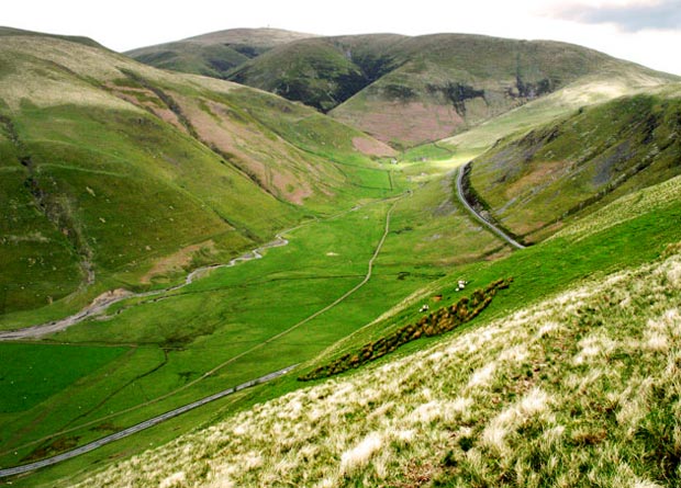
Rising Cleuch is a valley located in Lanarkshire, a historic county in central Scotland. Situated in the southern part of the country, the valley is known for its stunning natural beauty and picturesque landscapes.

Surrounded by rolling hills and bordered by the River Clyde, Rising Cleuch offers visitors a glimpse into the tranquil countryside of Scotland. The valley is characterized by its lush green meadows, scattered with vibrant wildflowers during the spring and summer months. The area is also home to a variety of wildlife, including deer, foxes, and a rich bird population.

Rising Cleuch is a popular destination for outdoor enthusiasts, offering a range of activities such as hiking, cycling, and fishing. The valley is crisscrossed by numerous walking trails, providing opportunities for both leisurely strolls and more challenging hikes. The nearby river is ideal for fishing enthusiasts, with salmon and trout being the most common catches.

In addition to its natural beauty, Rising Cleuch also boasts a rich historical heritage. The valley is dotted with remnants of old settlements, including ancient stone circles and burial sites, which offer a glimpse into the area's ancient past.

Overall, Rising Cleuch in Lanarkshire offers visitors a peaceful retreat amidst nature, with its scenic landscapes, outdoor activities, and historical charm.

If you have any feedback on the listing, please let us know in the comments section below.

Rising Cleuch Images

Images are sourced within 2km of 55.396081/-3.7489509 or Grid Reference NS8912. Thanks to Geograph Open Source API. All images are credited.

Aerials on Green Lowther Communications masts on Green Lowther above Middle Grain.
Aerials on Green Lowther
Communications masts on Green Lowther above Middle Grain.
Take the High Road And I was literally - walking along the road at over 2300ft that links Lowther Hill with Green Lowther both part of the radar station used by National Air Traffic Services. Some of the 100 plus turbines of Clyde Wind Farm can be seen in the distance beyond Green Lowther - today actually producing electricity.
Take the High Road
And I was literally - walking along the road at over 2300ft that links Lowther Hill with Green Lowther both part of the radar station used by National Air Traffic Services. Some of the 100 plus turbines of Clyde Wind Farm can be seen in the distance beyond Green Lowther - today actually producing electricity.
A Bend in the Road The high road linking Lowther Hill with Green Lowther just after the minor top of Green Trough. Though I hate walking on roads on a hillwalk the mile or so between the 2 Lowthers was pleasant enough and speeded up progress for a while on romp over the 5 Lowther Donalds - and 1 Graham which we are looking at in this photo - Green Lowther.
A Bend in the Road
The high road linking Lowther Hill with Green Lowther just after the minor top of Green Trough. Though I hate walking on roads on a hillwalk the mile or so between the 2 Lowthers was pleasant enough and speeded up progress for a while on romp over the 5 Lowther Donalds - and 1 Graham which we are looking at in this photo - Green Lowther.
Green Lowther and Lowther Hill from the air Patches of snow have survived in the deep north facing scars between the two summits. The Lowther Hill radar station is visible near the top of the photo, with Lowther Hill Ski Station also visible towards the top right corner.
Green Lowther and Lowther Hill from the air
Patches of snow have survived in the deep north facing scars between the two summits. The Lowther Hill radar station is visible near the top of the photo, with Lowther Hill Ski Station also visible towards the top right corner.
Southern Upland Way at Wanlockhead Flights of wooden steps assist on the ascent of the SU Way as it heads southeast towards the radar station on Lowther Hill.
Southern Upland Way at Wanlockhead
Flights of wooden steps assist on the ascent of the SU Way as it heads southeast towards the radar station on Lowther Hill.
Mountain Lodge, Wanlockhead The houses were originally built for workers at the Lowther Hill summit radar station. The Southern Upland Way passes to the right across Stake Hill.
Mountain Lodge, Wanlockhead
The houses were originally built for workers at the Lowther Hill summit radar station. The Southern Upland Way passes to the right across Stake Hill.
Mining relic, Wanlockhead A concrete framework on the hillside next to the Southern Upland Way, just one of the many remnants of at least three centuries of lead and silver mining here. Note the spoil heap of New Glencrieff Mine in the middle distance.
Mining relic, Wanlockhead
A concrete framework on the hillside next to the Southern Upland Way, just one of the many remnants of at least three centuries of lead and silver mining here. Note the spoil heap of New Glencrieff Mine in the middle distance.
Wanlockhead from Stake Hill A view of the village from the Southern Upland Way. The valley of the Wanlock Water is ahead with the slope of Wanlock Dod right.
Wanlockhead from Stake Hill
A view of the village from the Southern Upland Way. The valley of the Wanlock Water is ahead with the slope of Wanlock Dod right.
Southern Upland Way on Stake Hill The SU Way heads southeast, climbing steadily to Lowther Hill and its radar station. The reservoir collected water from the Mossy Burn and transferred it by tunnel to Wanlockhead to augment the supply to the lead mining operations.
Southern Upland Way on Stake Hill
The SU Way heads southeast, climbing steadily to Lowther Hill and its radar station. The reservoir collected water from the Mossy Burn and transferred it by tunnel to Wanlockhead to augment the supply to the lead mining operations.
Footbridge over the Mossy Burn On the Southern Upland Way SE of Wanlockhead with the masts on Green Lowther in view.
Footbridge over the Mossy Burn
On the Southern Upland Way SE of Wanlockhead with the masts on Green Lowther in view.
Service road to Lowther Hill The tarmac road gives access from Wanlockhead to the air traffic control radar station at the summit of Lowther Hill. The waymark post is at the junction with the Southern Upland Way coming up from Wanlockhead; 'AED' stands for Automatic External Defibrillator, just over a kilometre away if you really need one.
Service road to Lowther Hill
The tarmac road gives access from Wanlockhead to the air traffic control radar station at the summit of Lowther Hill. The waymark post is at the junction with the Southern Upland Way coming up from Wanlockhead; 'AED' stands for Automatic External Defibrillator, just over a kilometre away if you really need one.
Road to Wanlockhead On the service road from the Lowther Hill radar station, marked out with poles to help navigation if there is snow cover.
Road to Wanlockhead
On the service road from the Lowther Hill radar station, marked out with poles to help navigation if there is snow cover.
Service road from Wanlockhead The road on the ridge crest to Lowther Hill radar station.
Service road from Wanlockhead
The road on the ridge crest to Lowther Hill radar station.
Shortcleuch Reservoir A small reservoir on the Shortcleuch Water northwest of Green Lowther.
Shortcleuch Reservoir
A small reservoir on the Shortcleuch Water northwest of Green Lowther.
Service road descending to Wanlockhead The private road from the Lowther Hill radar station descending to the public road at Wanlockhead.
Service road descending to Wanlockhead
The private road from the Lowther Hill radar station descending to the public road at Wanlockhead.
Start of service road to Lowther Hill The surfaced road to the radar station starts at the gate secured by multiple padlocks arranged to allow access by authorised users.
Start of service road to Lowther Hill
The surfaced road to the radar station starts at the gate secured by multiple padlocks arranged to allow access by authorised users.
Cottages at Wanlockhead Cottages on Church Street in this former lead mining village.
Cottages at Wanlockhead
Cottages on Church Street in this former lead mining village.
Wanlockhead viewed from Black Hill The old lead-mining village of Wanlockhead is Scotland's highest village, at around 467 metres above sea level.
Wanlockhead viewed from Black Hill
The old lead-mining village of Wanlockhead is Scotland's highest village, at around 467 metres above sea level.
Show me another place!

Rising Cleuch is located at Grid Ref: NS8912 (Lat: 55.396081, Lng: -3.7489509)

Unitary Authority: South Lanarkshire

Police Authority: Lanarkshire

What 3 Words

///promotion.grief.skirt. Near Sanquhar, Dumfries & Galloway

Nearby Locations

Rising Cleuch

Related Wikis

Lowther Hills

The Lowther Hills, also sometimes known as the Lowthers, are an extensive area of hill country in the Southern Uplands of Scotland, though some sub-ranges...

Green Lowther

Green Lowther is a hill in the Lowther Hills range, part of the Southern Uplands of Scotland. It is the highest point of the Lowther Hills and lies in...

Leadhills and Wanlockhead Railway

The Leadhills and Wanlockhead Railway is a 2 ft (610 mm) narrow gauge railway in South Lanarkshire, Scotland. It is laid on the trackbed of the former...

Wanlockhead

Wanlockhead is a village in Dumfries and Galloway, Scotland, nestling in the Lowther Hills and 1 mile (2 kilometres) south of Leadhills at the head of...

Leadhills railway station

Leadhills railway station was opened on 1 October 1901 as the intermediate stop on the Leadhills and Wanlockhead Light Railway and served the lead mining...

Wanlockhead railway station

Wanlockhead railway station was opened on 1 October 1902 as the terminus on the Leadhills and Wanlockhead Light Railway and served the lead mining area...

Scots Mining Company House

The Scots Mining Company House, also known as Woodlands Hall, is an early-18th-century mansion house in Leadhills, South Lanarkshire, Scotland. The house...

Leadhills

Leadhills, originally settled for the accommodation of miners, is a village in South Lanarkshire, Scotland, 5+3⁄4 miles (9.3 km) WSW of Elvanfoot. The...

Nearby Amenities

Located within 500m of 55.396081,-3.7489509
Glen Franka Rig
Natural: peak
Lat/Long: 55.4003172/-3.7487449
The data included in this document is from www.openstreetmap.org. The data is made available under ODbL.

Have you been to Rising Cleuch?

Leave your review of Rising Cleuch below (or comments, questions and feedback).