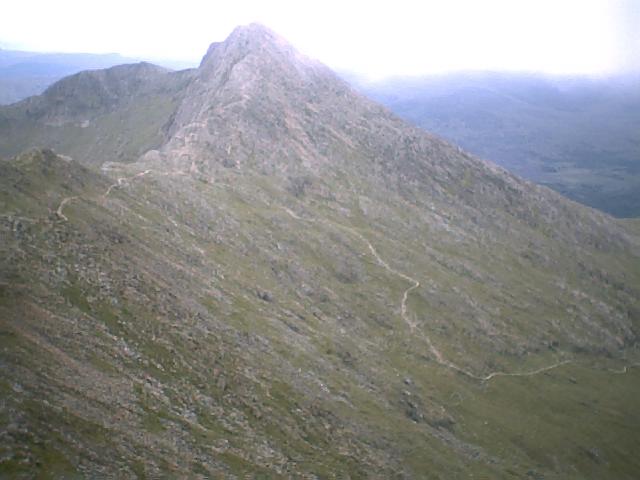
Central Gully

Valley in Caernarfonshire

Wales

Central Gully

Slate slab bridge on Afon Cwm Llan This bridge was built by miners to provide a short cut to the copper mines on slopes of Lliwedd.
Slate slab bridge on Afon Cwm Llan Credit: Eric Jones

The requested URL returned error: 429 Too Many Requests

If you have any feedback on the listing, please let us know in the comments section below.

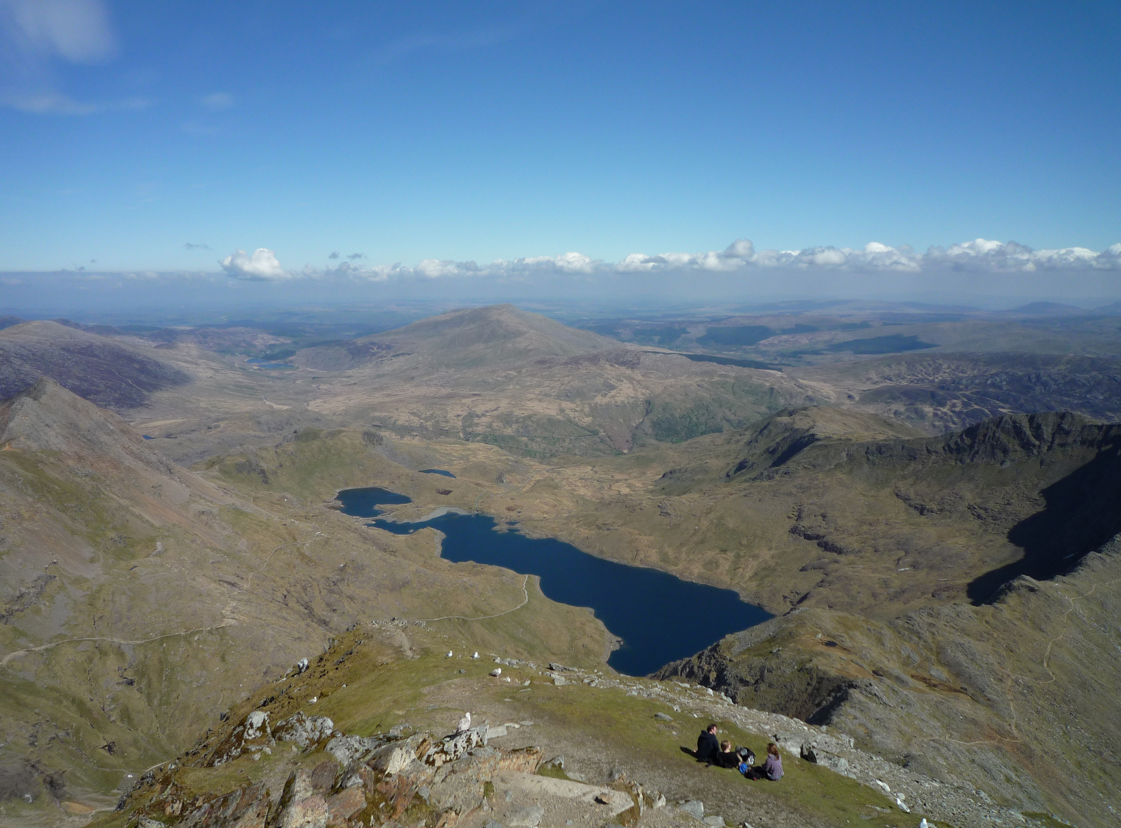
Central Gully Images

Images are sourced within 2km of 53.059571/-4.0550664 or Grid Reference SH6253. Thanks to Geograph Open Source API. All images are credited.

Slate slab bridge on Afon Cwm Llan This bridge was built by miners to provide a short cut to the copper mines on slopes of Lliwedd.
Slate slab bridge on Afon Cwm Llan
This bridge was built by miners to provide a short cut to the copper mines on slopes of Lliwedd.
Waterfall on Afon Cwm Llan Afon Cwm Llan is a spate river.
Waterfall on Afon Cwm Llan
Afon Cwm Llan is a spate river.
Rhaeadr Cwm Llan waterfall
Cwm Llan waterfall in full spate
Ruined copper mine buildings near Plas Cwm Llan
Hawthorns by the route to Cwm Llan Hawthorns stand out against the low contrast background of Cwm Llan in low cloud on a dreich November day. The Watkin path heads up there past the Afon Cwm Llan waterfalls, and straight into the clouds that are starting to bring the level up. The weather might mean a less crowded ascent to Snowdon, but the views would hardly be the most rewarding, so this was a lower-level walk aiming to stay below cloudbase and return to Llyn Dinas via a permissive path to Craflwyn.
Hawthorns by the route to Cwm Llan
Hawthorns stand out against the low contrast background of Cwm Llan in low cloud on a dreich November day. The Watkin path heads up there past the Afon Cwm Llan waterfalls, and straight into the clouds that are starting to bring the level up. The weather might mean a less crowded ascent to Snowdon, but the views would hardly be the most rewarding, so this was a lower-level walk aiming to stay below cloudbase and return to Llyn Dinas via a permissive path to Craflwyn.
A spectacular viewpoint Bwlch Cwm Llan gives a good view into Cwm Llan. The Watkin Path to Yr Wyddfa passes through the quarries left of centre - it can just be seen.
A spectacular viewpoint
Bwlch Cwm Llan gives a good view into Cwm Llan. The Watkin Path to Yr Wyddfa passes through the quarries left of centre - it can just be seen.
Snowdon viewed from near Boston Lodge A distance of some 10 miles from the camera position, the geography of Cwm Glaslyn and Treath Mawr allows a clear view of the mountain.
Snowdon viewed from near Boston Lodge
A distance of some 10 miles from the camera position, the geography of Cwm Glaslyn and Treath Mawr allows a clear view of the mountain.
Y Lliwedd from Allt Maenderyn
Snowdon Summit Station Throat The summit of the Snowdon Mountain Railway
Snowdon Summit Station Throat
The summit of the Snowdon Mountain Railway
Flush Bracket Benchmark, Snowdon Summit Detail of the Ordnance Survey flush bracket benchmark on the topograph on the summit of Snowdon.
The Ordnance Survey trigonometrical column was demolished and replaced by a topograph (photograph <a href="https://www.geograph.org.uk/photo/7236077">SH6054 : Topograph on Snowdon Summit</a>); the flush bracket being incorporated into this.  When in situ in the original Ordnance Survey column the flush bracket, benchmark number 10684, marked a height of 1086.002m above sea level (Ordnance Datum Newlyn), last levelled in 1961.
Flush Bracket Benchmark, Snowdon Summit
Detail of the Ordnance Survey flush bracket benchmark on the topograph on the summit of Snowdon. The Ordnance Survey trigonometrical column was demolished and replaced by a topograph (photograph SH6054 : Topograph on Snowdon Summit); the flush bracket being incorporated into this. When in situ in the original Ordnance Survey column the flush bracket, benchmark number 10684, marked a height of 1086.002m above sea level (Ordnance Datum Newlyn), last levelled in 1961.
Topograph on Snowdon Summit The Ordnance Survey trigonometrical column on the summit of Snowdon was demolished and replaced by a topograph; some Ordnance Survey hardware from the trigonometrical column and a meteorological station being incorporated into this.  When in situ in the original Ordnance Survey column the flush bracket, benchmark number 10684, marked a height of 1086.002m above sea level (Ordnance Datum Newlyn), last levelled in 1961 (photograph <a href="https://www.geograph.org.uk/photo/7236031">SH6054 : Flush Bracket Benchmark, Snowdon Summit</a>).
On a misty day, the three men standing idly chatting on the summit regrettably did not think that people waiting to take photographs was a good enough reason for them to consider moving politely to one side.
Topograph on Snowdon Summit
The Ordnance Survey trigonometrical column on the summit of Snowdon was demolished and replaced by a topograph; some Ordnance Survey hardware from the trigonometrical column and a meteorological station being incorporated into this. When in situ in the original Ordnance Survey column the flush bracket, benchmark number 10684, marked a height of 1086.002m above sea level (Ordnance Datum Newlyn), last levelled in 1961 (photograph SH6054 : Flush Bracket Benchmark, Snowdon Summit). On a misty day, the three men standing idly chatting on the summit regrettably did not think that people waiting to take photographs was a good enough reason for them to consider moving politely to one side.
A sunrise cloud inversion, looking at Y Wyddfa from Moel Siabod
View east from near Snowdon summit A spectacular vista of Glaslyn and Llyn-Llydaw lakes and the Pyg track and miners' track paths and in the distance, the A4086 road.
View east from near Snowdon summit
A spectacular vista of Glaslyn and Llyn-Llydaw lakes and the Pyg track and miners' track paths and in the distance, the A4086 road.
View from the top Looking approximately northeast from Snowdon summit.  There was only about a 10-minute wait in the queue.
View from the top
Looking approximately northeast from Snowdon summit. There was only about a 10-minute wait in the queue.
Paths to Snowdon from the east The Pyg track clings to the side of Crib y Ddysgl and the miners' track passes around Glaslyn.  The paths meet just out of view to the left for the final climb.  Both paths start from Gorhwysfa on the A4086.
Paths to Snowdon from the east
The Pyg track clings to the side of Crib y Ddysgl and the miners' track passes around Glaslyn. The paths meet just out of view to the left for the final climb. Both paths start from Gorhwysfa on the A4086.
Snowdon: at the top A few visitors out of several thousand on the mountain on a spectacular cloudless July day.  The rocks at the summit are part of the bedded pyroclastic formation: igneous bedrock formed between 458.4 and 449 million years ago during the Ordovician period.
Snowdon: at the top
A few visitors out of several thousand on the mountain on a spectacular cloudless July day. The rocks at the summit are part of the bedded pyroclastic formation: igneous bedrock formed between 458.4 and 449 million years ago during the Ordovician period.
Enjoying the view Four hikers -- and a seagull -- survey the course of the Snowdon Ranger path in the middle-distance with the peak of Moel Eilio (726 m) farther back.  In the far distance is the Menai Strait and Anglesey.
Enjoying the view
Four hikers -- and a seagull -- survey the course of the Snowdon Ranger path in the middle-distance with the peak of Moel Eilio (726 m) farther back. In the far distance is the Menai Strait and Anglesey.
Show me another place!

Central Gully is located at Grid Ref: SH6253 (Lat: 53.059571, Lng: -4.0550664)

Unitary Authority: Gwynedd

Police Authority: North Wales

What 3 Words

///fitter.deserved.dentistry. Near Llanberis, Gwynedd

Related Wikis

Y Lliwedd East Peak

Y Lliwedd East Peak is the twin top of Y Lliwedd in the Snowdonia National Park, North Wales. It is only 5 metres shorter than the main summit of Y Lliwedd...

Y Lliwedd

Y Lliwedd is a mountain, connected to Snowdon in the Snowdonia National Park, North Wales. Its summit lies 898 metres (2,946 ft) above sea level. The eastern...

Lliwedd Bach

Lliwedd Bach is a top of Y Lliwedd in the Snowdonia National Park, North Wales. It is the last "top" on the main ridge of Y Lliwedd, the other being Y...

Llyn Llydaw

Llyn Llydaw (Welsh for 'Brittany lake') is a natural lake in Snowdonia National Park on the flanks of Snowdon, Wales' highest mountain. This long thin...

Nearby Amenities

Located within 500m of 53.059571,-4.0550664
Y Lliwedd (West Peak)
Ele: 898
Name Cy: Y Lliwedd
Natural: peak
Source: OS 1:25k
Wikidata: Q3399839
Wikipedia: en:Y Lliwedd
Lat/Long: 53.0593976/-4.0571477
Historic: memorial
Source: OS 1:25k
Lat/Long: 53.0605352/-4.0551796
Y Lliwedd (East Peak)
Ele: 893
Natural: peak
Lat/Long: 53.0587365/-4.0546507
Lliwedd Bach
Ele: 818
Natural: peak
Lat/Long: 53.0586258/-4.049411
The data included in this document is from www.openstreetmap.org. The data is made available under ODbL.

Have you been to Central Gully?

Leave your review of Central Gully below (or comments, questions and feedback).