An Lairig

Valley in Inverness-shire

Scotland

An Lairig

Loch a'Bhealaich Leamhain Looking down to the loch on an ascent of Creag Pitridh and Geal Charn from the north shore.
Loch a'Bhealaich Leamhain Credit: richard Aston

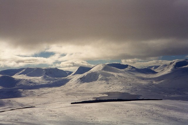
An Lairig is a picturesque valley located in Inverness-shire, Scotland. Nestled between the Monadhliath and Grampian mountain ranges, this remote and tranquil location offers stunning views of the surrounding landscape.

The valley is characterized by rolling hills covered in lush green vegetation, with a small river meandering through the center. The area is rich in wildlife, with red deer, golden eagles, and otters often spotted by visitors exploring the valley.

An Lairig is a popular destination for hikers and outdoor enthusiasts, with numerous walking trails and paths crisscrossing the valley. The terrain ranges from gentle slopes to more challenging ascents, making it suitable for all levels of fitness.

Visitors to An Lairig can also enjoy camping and picnicking in the peaceful surroundings, or simply take in the beauty of the unspoiled Scottish countryside. The valley is a perfect place to escape the hustle and bustle of everyday life and immerse oneself in the natural beauty of the Scottish Highlands.

If you have any feedback on the listing, please let us know in the comments section below.

An Lairig Images

Images are sourced within 2km of 56.871565/-4.4460794 or Grid Reference NN5178. Thanks to Geograph Open Source API. All images are credited.

Loch a'Bhealaich Leamhain Looking down to the loch on an ascent of Creag Pitridh and Geal Charn from the north shore.
Loch a'Bhealaich Leamhain
Looking down to the loch on an ascent of Creag Pitridh and Geal Charn from the north shore.
Southwest from Meall Cruaidh A splendid panorama of the hills from Ben Alder (L) round to Beinn a' Chlachair (R) with Carn Dearg in the centre, the steep ridge (Lancet Edge) of Sgor Iuthairn to its left and Loch Pattack below. The viewpoint is Meall Cruaidh at the SW end of The Fara ridge above Loch Ericht.
Southwest from Meall Cruaidh
A splendid panorama of the hills from Ben Alder (L) round to Beinn a' Chlachair (R) with Carn Dearg in the centre, the steep ridge (Lancet Edge) of Sgor Iuthairn to its left and Loch Pattack below. The viewpoint is Meall Cruaidh at the SW end of The Fara ridge above Loch Ericht.
Path in An Lairig More evidence of good path maintenance
Path in An Lairig
More evidence of good path maintenance
Path by Allt Cam, An Lairig
Carn Dearg And Ben Alder forest.
Carn Dearg
And Ben Alder forest.
Lochan a Bhealaich Leamhain Taken from the stalkers' path contouring round the end of Beinn A' Chlachair.
Lochan a Bhealaich Leamhain
Taken from the stalkers' path contouring round the end of Beinn A' Chlachair.
Eastern Shoulder of Carn Dearg Above Culra Bothy
Càrn Dearg (Ben Alder) One of the long ridge of tops immediately north of Ben Alder. There is an obvious corrie to the right, Coire Sròn an Nid.  View across Loch Ericht from between Geal-charn and A' Mharconaich.
Càrn Dearg (Ben Alder)
One of the long ridge of tops immediately north of Ben Alder. There is an obvious corrie to the right, Coire Sròn an Nid. View across Loch Ericht from between Geal-charn and A' Mharconaich.
Coire Sròn an Nid, Càrn Dearg A view over Loch Ericht from the ridge between Geal-charn and A' Mharconaich towards a rocky corrie on Càrn Dearg.
Coire Sròn an Nid, Càrn Dearg
A view over Loch Ericht from the ridge between Geal-charn and A' Mharconaich towards a rocky corrie on Càrn Dearg.
Allt Cam Draining An Larig, quite a big river for this high up in the hills.
Allt Cam
Draining An Larig, quite a big river for this high up in the hills.
Track to An Lairig West of Loch Pattack.
Track to An Lairig
West of Loch Pattack.
An Lairig and Mullach Coire an Iubhair High moorland west of Loch Pattack. The track links up with a high quality path over to Lochan na h-Earba.
An Lairig and Mullach Coire an Iubhair
High moorland west of Loch Pattack. The track links up with a high quality path over to Lochan na h-Earba.
View towards Beinn a' Chlachair The eastern end of An Lairig.
View towards Beinn a' Chlachair
The eastern end of An Lairig.
Bogwood Remains of trees in eroding peat at the eastern end of An Lairig.
Bogwood
Remains of trees in eroding peat at the eastern end of An Lairig.
Bogs at the foot of Carn Dearg Nearly 500m up at glen level, the bogs give way to the eastern end of a long ridge extending all the way to Strath Ossian over Geal Chàrn, Aonach Beag (with the strange use of capitals by the OS) and Beinn Eibhinn.
Bogs at the foot of Carn Dearg
Nearly 500m up at glen level, the bogs give way to the eastern end of a long ridge extending all the way to Strath Ossian over Geal Chàrn, Aonach Beag (with the strange use of capitals by the OS) and Beinn Eibhinn.
Carn Dearg View from the east with Coire Sròn an Nid on the left.
Carn Dearg
View from the east with Coire Sròn an Nid on the left.
Rocks and stones at summit area of Carn Dearg Barren rockiness at the broad summit area of Carn Dearg in the Ben Alder Forest.
The extensively snowed mountain in the distance, to the north, is the 1049 m. peak, Geal Charn.
Rocks and stones at summit area of Carn Dearg
Barren rockiness at the broad summit area of Carn Dearg in the Ben Alder Forest. The extensively snowed mountain in the distance, to the north, is the 1049 m. peak, Geal Charn.
Track leading to Culra Lodge.
Show me another place!

An Lairig is located at Grid Ref: NN5178 (Lat: 56.871565, Lng: -4.4460794)

Unitary Authority: Highland

Police Authority: Highlands and Islands

What 3 Words

///firming.lecturing.kinds. Near Newtonmore, Highland

Nearby Locations

An Lairig

Related Wikis

Geal Charn (Loch Laggan)

Geal Charn (1,049 m) is a mountain in the Grampian Mountains of Scotland. It is situated in the Highlands, on the southern shore of Loch Laggan. A large...

Beinn a' Chlachair

Beinn a' Chlachair (1,087 m) is a mountain in the Grampian Mountains of Scotland. It lies south of Loch Laggan, near the remote hamlet of Kinloch Laggan...

Geal-Chàrn

Geal-Chàrn (Scottish Gaelic: White Peak) is a mountain in the Highlands of Scotland, 14 kilometres North East of Corrour railway station == See also... ==

Lochan na h-Earba

The single name Lochan na h-Earba is applied to two lochs to the south of Loch Laggan in Highland, Scotland, close to the historic boundary between Lochaber...

Have you been to An Lairig?

Leave your review of An Lairig below (or comments, questions and feedback).