Gleniffer Glen

Valley in Renfrewshire

Scotland

Gleniffer Glen

Dry-stone wall and fence The space between the wall and fence is more worn than the surrounding moorland because, as shown on the map, the route between them is part of a footpath. For a good summary of that path, see <a href="https://www.geograph.org.uk/photo/369064">NS4859 : Paisley - Brownside Braes - Harelaw  Reservoir</a>.

The same fence and wall are shown in <a href="https://www.geograph.org.uk/photo/2308667">NS4860 : Dry-stone wall and fence</a>, which was taken at a point about 270 metres further along the same path.
Dry-stone wall and fence Credit: Lairich Rig

Gleniffer Glen, located in Renfrewshire, Scotland, is a picturesque valley renowned for its natural beauty and tranquility. Nestled amidst rolling hills and lush greenery, this idyllic landscape offers visitors a peaceful retreat from the hustle and bustle of urban life.

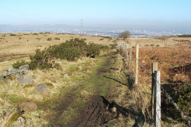
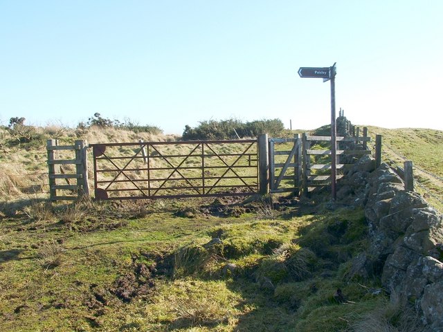
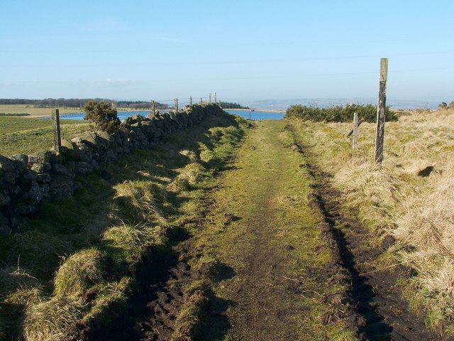
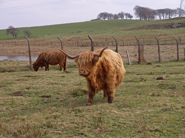
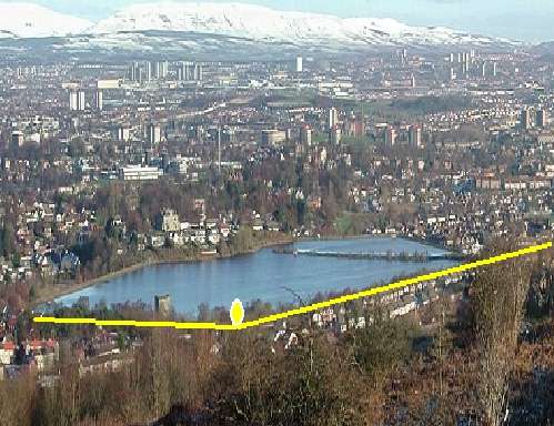
The glen is home to the Gleniffer Braes Country Park, a vast expanse of open moorland, woodlands, and riverside walks. It is a popular destination for outdoor enthusiasts, hikers, and nature lovers. The park boasts an extensive network of trails, allowing visitors to explore the area's diverse flora and fauna, as well as soak in breathtaking panoramic views of the surrounding countryside.

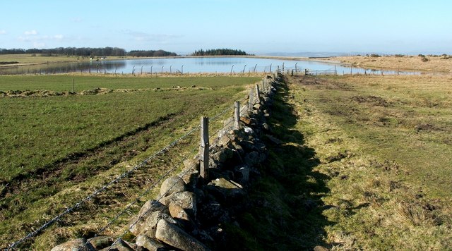
One of the main attractions in Gleniffer Glen is the Gleniffer Braes Reservoir, which provides a serene setting for fishing and birdwatching. The reservoir is home to a variety of bird species, including herons, swans, and ducks, making it a haven for bird enthusiasts. Visitors can also indulge in recreational activities such as sailing and canoeing on the reservoir.

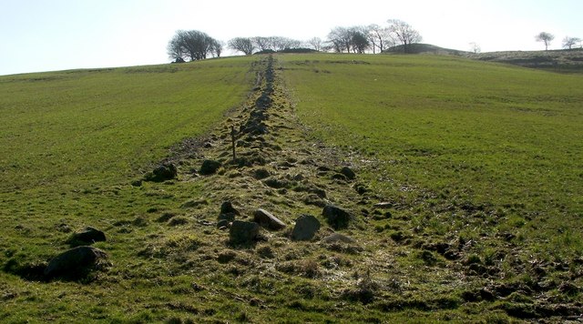
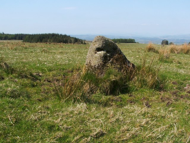
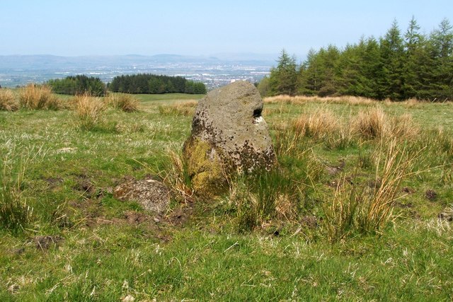
The glen is also steeped in history, with archaeological remains dating back to the Iron Age. The area offers several historic sites, including the Prehistoric Fort, where visitors can explore the remnants of an ancient hillfort.

Gleniffer Glen is easily accessible, located just a short drive from the town of Paisley and less than an hour's drive from Glasgow. Its tranquil atmosphere, stunning landscapes, and rich history make it a must-visit destination for those seeking a peaceful escape into nature.

If you have any feedback on the listing, please let us know in the comments section below.

Gleniffer Glen Images

Images are sourced within 2km of 55.815104/-4.4537388 or Grid Reference NS4660. Thanks to Geograph Open Source API. All images are credited.

Dry-stone wall and fence The space between the wall and fence is more worn than the surrounding moorland because, as shown on the map, the route between them is part of a footpath. For a good summary of that path, see <a href="https://www.geograph.org.uk/photo/369064">NS4859 : Paisley - Brownside Braes - Harelaw  Reservoir</a>.

The same fence and wall are shown in <a href="https://www.geograph.org.uk/photo/2308667">NS4860 : Dry-stone wall and fence</a>, which was taken at a point about 270 metres further along the same path.
Dry-stone wall and fence
The space between the wall and fence is more worn than the surrounding moorland because, as shown on the map, the route between them is part of a footpath. For a good summary of that path, see NS4859 : Paisley - Brownside Braes - Harelaw Reservoir. The same fence and wall are shown in NS4860 : Dry-stone wall and fence, which was taken at a point about 270 metres further along the same path.
Signpost at footpath junction The signpost is located at a three-way junction of paths.

The sign pointing to the left says "Paisley", and points along the route shown in <a href="https://www.geograph.org.uk/photo/2308698">NS4859 : Dry-stone wall and fence</a> and <a href="https://www.geograph.org.uk/photo/2308667">NS4860 : Dry-stone wall and fence</a>.

Another, pointing towards the photographer's position, reads "Killoch Glen via Glenburn Resr"; for that route, see <a href="https://www.geograph.org.uk/photo/2309088">NS4859 : Path to Glenburn Reservoir</a>.

The third, pointing in the opposite direction, reads "Barrhead / Killoch Glen via Harelaw Resr"; for a view back along that route, see <a href="https://www.geograph.org.uk/photo/2309100">NS4859 : Path from Killoch Glen</a>.
Signpost at footpath junction
The signpost is located at a three-way junction of paths. The sign pointing to the left says "Paisley", and points along the route shown in NS4859 : Dry-stone wall and fence and NS4860 : Dry-stone wall and fence. Another, pointing towards the photographer's position, reads "Killoch Glen via Glenburn Resr"; for that route, see NS4859 : Path to Glenburn Reservoir. The third, pointing in the opposite direction, reads "Barrhead / Killoch Glen via Harelaw Resr"; for a view back along that route, see NS4859 : Path from Killoch Glen.
Path to Glenburn Reservoir This photograph, which was taken from beside the signpost that is shown in <a href="https://www.geograph.org.uk/photo/2309070">NS4859 : Signpost at footpath junction</a>, shows one of the three paths that is indicated there. <a href="https://www.geograph.org.uk/photo/2308500">NS4760 : Glenburn Reservoir</a> is visible about 240 metres ahead.

For a view from a point a little further along the path, see <a href="https://www.geograph.org.uk/photo/2310062">NS4759 : Path to Glenburn Reservoir</a>.
Path to Glenburn Reservoir
This photograph, which was taken from beside the signpost that is shown in NS4859 : Signpost at footpath junction, shows one of the three paths that is indicated there. NS4760 : Glenburn Reservoir is visible about 240 metres ahead. For a view from a point a little further along the path, see NS4759 : Path to Glenburn Reservoir.
Path from Killoch Glen For the previous part of the route, see <a href="https://www.geograph.org.uk/photo/2310031">NS4859 : Path from Killoch Glen</a>. That path makes a sharp turn near <a href="https://www.geograph.org.uk/photo/2309150">NS4859 : Harelaw Reservoir</a>. The present photograph shows the part of the route beyond that corner; it leads towards the signpost that is shown in <a href="https://www.geograph.org.uk/photo/2309070">NS4859 : Signpost at footpath junction</a>.

The top of that signpost is just visible in this photograph; it can be seen straight ahead on the path, with <a href="https://www.geograph.org.uk/photo/2308500">NS4760 : Glenburn Reservoir</a> visible behind it.
Path from Killoch Glen
For the previous part of the route, see NS4859 : Path from Killoch Glen. That path makes a sharp turn near NS4859 : Harelaw Reservoir. The present photograph shows the part of the route beyond that corner; it leads towards the signpost that is shown in NS4859 : Signpost at footpath junction. The top of that signpost is just visible in this photograph; it can be seen straight ahead on the path, with NS4760 : Glenburn Reservoir visible behind it.
Path to Glenburn Reservoir This is a view from a point further along the path that is shown in <a href="https://www.geograph.org.uk/photo/2309088">NS4859 : Path to Glenburn Reservoir</a>; <a href="https://www.geograph.org.uk/photo/2308500">NS4760 : Glenburn Reservoir</a> is visible ahead. Not far ahead, the wall and fence whose line the present photograph follows is met from the left by an old field boundary; see <a href="https://www.geograph.org.uk/photo/2310077">NS4759 : View along old field boundary</a>.

Still further ahead is <a href="https://www.geograph.org.uk/photo/5423845">NS4760 : The start of a path beside the Glenburn Reservoir</a>.
Path to Glenburn Reservoir
This is a view from a point further along the path that is shown in NS4859 : Path to Glenburn Reservoir; NS4760 : Glenburn Reservoir is visible ahead. Not far ahead, the wall and fence whose line the present photograph follows is met from the left by an old field boundary; see NS4759 : View along old field boundary. Still further ahead is NS4760 : The start of a path beside the Glenburn Reservoir.
View along old field boundary This boundary is in the form of a dry-stone dyke, which is now in poor condition. It is marked on the first-edition OS map, which was surveyed in 1858, and it may be considerably older than that.

See <a href="https://www.geograph.org.uk/photo/2310062">NS4759 : Path to Glenburn Reservoir</a>, where the line of the boundary can be seen not far ahead, approaching the more recent wall from the left. The present photograph was taken from the point where the two meet.

Even in this photograph, it is clear that at the top of the hill, among the trees, there are some ruins; one section lies directly beyond the far end of the field boundary, and a smaller section to the left. These are the remains of the farmstead of Duchallaw, which is shown on the first-edition OS map.
View along old field boundary
This boundary is in the form of a dry-stone dyke, which is now in poor condition. It is marked on the first-edition OS map, which was surveyed in 1858, and it may be considerably older than that. See NS4759 : Path to Glenburn Reservoir, where the line of the boundary can be seen not far ahead, approaching the more recent wall from the left. The present photograph was taken from the point where the two meet. Even in this photograph, it is clear that at the top of the hill, among the trees, there are some ruins; one section lies directly beyond the far end of the field boundary, and a smaller section to the left. These are the remains of the farmstead of Duchallaw, which is shown on the first-edition OS map.
Highland Cows, Brownside Braes Fenced off Glenburn Reservoir on the left.
Highland Cows, Brownside Braes
Fenced off Glenburn Reservoir on the left.
Transmitter mast at Sergeant Law This is one of three masts on the hill. The other two stand not far to the WSW: <a href="https://www.geograph.org.uk/photo/2939846">NS4559 : Transmitter masts at Sergeant Law</a>. They provide DAB digital radio coverage, and, according to Secret Scotland, they are also leased by the MOD: <span class="nowrap"><a title="http://www.secretscotland.org.uk/index.php/Secrets/SergeantLawMasts" rel="nofollow ugc noopener" href="http://www.secretscotland.org.uk/index.php/Secrets/SergeantLawMasts">Link</a><img style="margin-left:2px;" alt="External link" title="External link - shift click to open in new window" src="https://s1.geograph.org.uk/img/external.png" width="10" height="10"/></span>
Transmitter mast at Sergeant Law
This is one of three masts on the hill. The other two stand not far to the WSW: NS4559 : Transmitter masts at Sergeant Law. They provide DAB digital radio coverage, and, according to Secret Scotland, they are also leased by the MOD: LinkExternal link
Transmitter masts at Sergeant Law These are two of a group of three masts on a hill called Sergeant Law. These two are near the summit of the hill, while the other one is further to the ENE: <a href="https://www.geograph.org.uk/photo/2939828">NS4559 : Transmitter mast at Sergeant Law</a>; see that item for further information.

There is a Serjeantlaw (farm) on Roy's Military Survey of Scotland (1740s-50s), showing that the hill had its present name at that time. A "law" is a round/conical, generally isolated hill.
Transmitter masts at Sergeant Law
These are two of a group of three masts on a hill called Sergeant Law. These two are near the summit of the hill, while the other one is further to the ENE: NS4559 : Transmitter mast at Sergeant Law; see that item for further information. There is a Serjeantlaw (farm) on Roy's Military Survey of Scotland (1740s-50s), showing that the hill had its present name at that time. A "law" is a round/conical, generally isolated hill.
Possible standing stone The stone is about a metre tall, and it stands about 380 metres to the north-east of the summit of Sergeant Law. It may or not be an antiquity, but I have recorded it here because it appears to be very similar to other stones nearby that are marked as antiquities on the map: <a href="https://www.geograph.org.uk/photo/2311485">NS4560 : Standing stones at Gleniffer Braes</a>.

See <a href="https://www.geograph.org.uk/photo/2943483">NS4559 : Possible standing stone</a> for another view of this stone, and for further details.
Possible standing stone
The stone is about a metre tall, and it stands about 380 metres to the north-east of the summit of Sergeant Law. It may or not be an antiquity, but I have recorded it here because it appears to be very similar to other stones nearby that are marked as antiquities on the map: NS4560 : Standing stones at Gleniffer Braes. See NS4559 : Possible standing stone for another view of this stone, and for further details.
Possible standing stone The stone is about a metre tall, and it stands about 380 metres to the north-east of the summit of Sergeant Law. It may or may not be a genuine antiquity (it has not been recorded as such), but it caught my attention because it appears to be very much like other stones nearby which are considered to be standing stones, and which are marked as antiquities on the map: <a href="https://www.geograph.org.uk/photo/2311485">NS4560 : Standing stones at Gleniffer Braes</a>. For this reason, I feel that the stone is worth pointing out and recording.

For another view of this stone, see <a href="https://www.geograph.org.uk/photo/2943482">NS4559 : Possible standing stone</a>.
Possible standing stone
The stone is about a metre tall, and it stands about 380 metres to the north-east of the summit of Sergeant Law. It may or may not be a genuine antiquity (it has not been recorded as such), but it caught my attention because it appears to be very much like other stones nearby which are considered to be standing stones, and which are marked as antiquities on the map: NS4560 : Standing stones at Gleniffer Braes. For this reason, I feel that the stone is worth pointing out and recording. For another view of this stone, see NS4559 : Possible standing stone.
Sergeant Law Masts and one of the powerlines radiating from the nearby substation.
Sergeant Law
Masts and one of the powerlines radiating from the nearby substation.
An unnamed summit in the Fereneze Braes A large cairn and a wind-battered beech tree at the summit. Despite the relatively modest height, there is a wonderful 360° panorama from the summit.
An unnamed summit in the Fereneze Braes
A large cairn and a wind-battered beech tree at the summit. Despite the relatively modest height, there is a wonderful 360° panorama from the summit.
Glenburn Reservoir Viewed from an unnamed summit in the Fereneze Braes.
Glenburn Reservoir
Viewed from an unnamed summit in the Fereneze Braes.
Road to Thornliemuir Farm In the Gleniffer Braes.
Road to Thornliemuir Farm
In the Gleniffer Braes.
Paisley from the air Gleniffer Braes golf course and Stanely Loch are prominent in the foreground. Glasgow Airport can be seen to the left of centre.
Paisley from the air
Gleniffer Braes golf course and Stanely Loch are prominent in the foreground. Glasgow Airport can be seen to the left of centre.
Pylons and power lines Seen from Sergeantlaw Road.
Pylons and power lines
Seen from Sergeantlaw Road.
Communication masts Just below the summit of Sergeant Law, a 230m hill.
Communication masts
Just below the summit of Sergeant Law, a 230m hill.
Show me another place!

Gleniffer Glen is located at Grid Ref: NS4660 (Lat: 55.815104, Lng: -4.4537388)

Unitary Authority: Renfrewshire

Police Authority: Renfrewshire and Inverclyde

What 3 Words

///deep.puzzle.loads. Near Paisley, Renfrewshire

Related Wikis

Stanely railway station

Stanely was a railway station to the west of Paisley, Renfrewshire, Scotland. == History == The station was originally part of the Paisley and Barrhead...

Foxbar

Foxbar is a district of Paisley, bordered by the Gleniffer Braes and Paisley town centre. Consisting mostly of residential areas, Foxbar has rapidly grown...
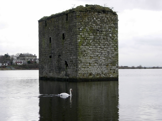
Stanely Castle

Stanely Castle is located in the waters of Stanely Reservoir, to the south of Paisley, Scotland, at the foot of the Gleniffer Braes. It was probably built...

Gleniffer High School

Gleniffer High School is a Scottish state state school school located in Paisley for boys and girls aged 11 to 18. Since 1988, Gleniffer has been located...

Nearby Amenities

Located within 500m of 55.815104,-4.4537388
Barrier: kissing_gate
Lat/Long: 55.812538/-4.459436
Gleniffer Braes
Tourism: viewpoint
Lat/Long: 55.8137505/-4.4542038
Man Made: silo
Lat/Long: 55.8187228/-4.4566276
Barrier: kissing_gate
Lat/Long: 55.8127617/-4.459619
Bench
Backrest: yes
Colour: black
Direction: 340
Material: plastic
Lat/Long: 55.8126872/-4.4587226
Bench
Lat/Long: 55.8142088/-4.4528296
Bench
Lat/Long: 55.81483/-4.4525692
Bench
Lat/Long: 55.8144415/-4.4528592
Bench
Lat/Long: 55.8143537/-4.4469655
Waste Basket
Colour: black
Material: metal
Waste: trash
Lat/Long: 55.8125843/-4.4594809
Board Type: nature
Direction: 210
Information: board
Tourism: information
Lat/Long: 55.8125974/-4.4593441
Barrier: kissing_gate
Lat/Long: 55.8142967/-4.4611982
The data included in this document is from www.openstreetmap.org. The data is made available under ODbL.

Have you been to Gleniffer Glen?

Leave your review of Gleniffer Glen below (or comments, questions and feedback).