Barnton

Settlement in Cheshire

England

Barnton

Anderton Boat Lift Located near Northwich in Cheshire, the Anderton Boat Lift is one of the greatest monuments to Britain's last canal age and known as the "Cathedral of the Canals". 
Built in 1875 it was the world's first and is currently the UK's only Boat Lift.
(From <span class="nowrap"><a title="http://www.andertonboatlift.co.uk/" rel="nofollow ugc noopener" href="http://www.andertonboatlift.co.uk/">Link</a><img style="margin-left:2px;" alt="External link" title="External link - shift click to open in new window" src="https://s1.geograph.org.uk/img/external.png" width="10" height="10"/></span> )
Anderton Boat Lift Credit: Andy Stephenson

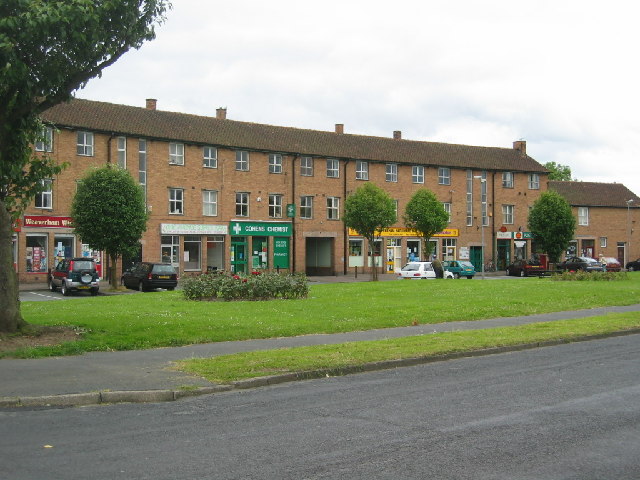
Barnton is a small village located in the county of Cheshire, England. Situated approximately 14 miles southwest of Manchester, it lies on the banks of the River Weaver and is part of the larger town of Northwich. With a population of around 9,000 residents, Barnton offers a close-knit community atmosphere.

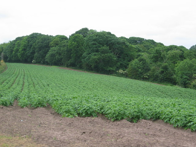
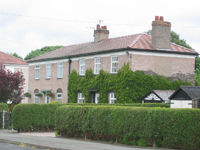
The village boasts a rich history, dating back to the Roman era when a settlement was established in the area. Barnton grew as a rural village, with agriculture playing a significant role in the local economy. Today, it retains its charming character, with a mix of traditional and modern architecture.

Barnton is well-connected to the surrounding areas, with good transport links including nearby access to the M56 motorway and Northwich railway station. The village provides a range of amenities, including local shops, a supermarket, pubs, and restaurants, catering to the needs of residents.

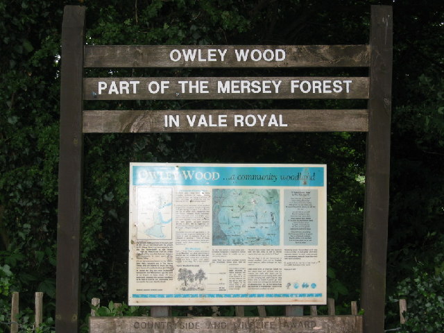
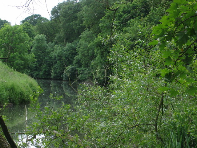
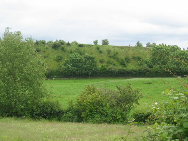
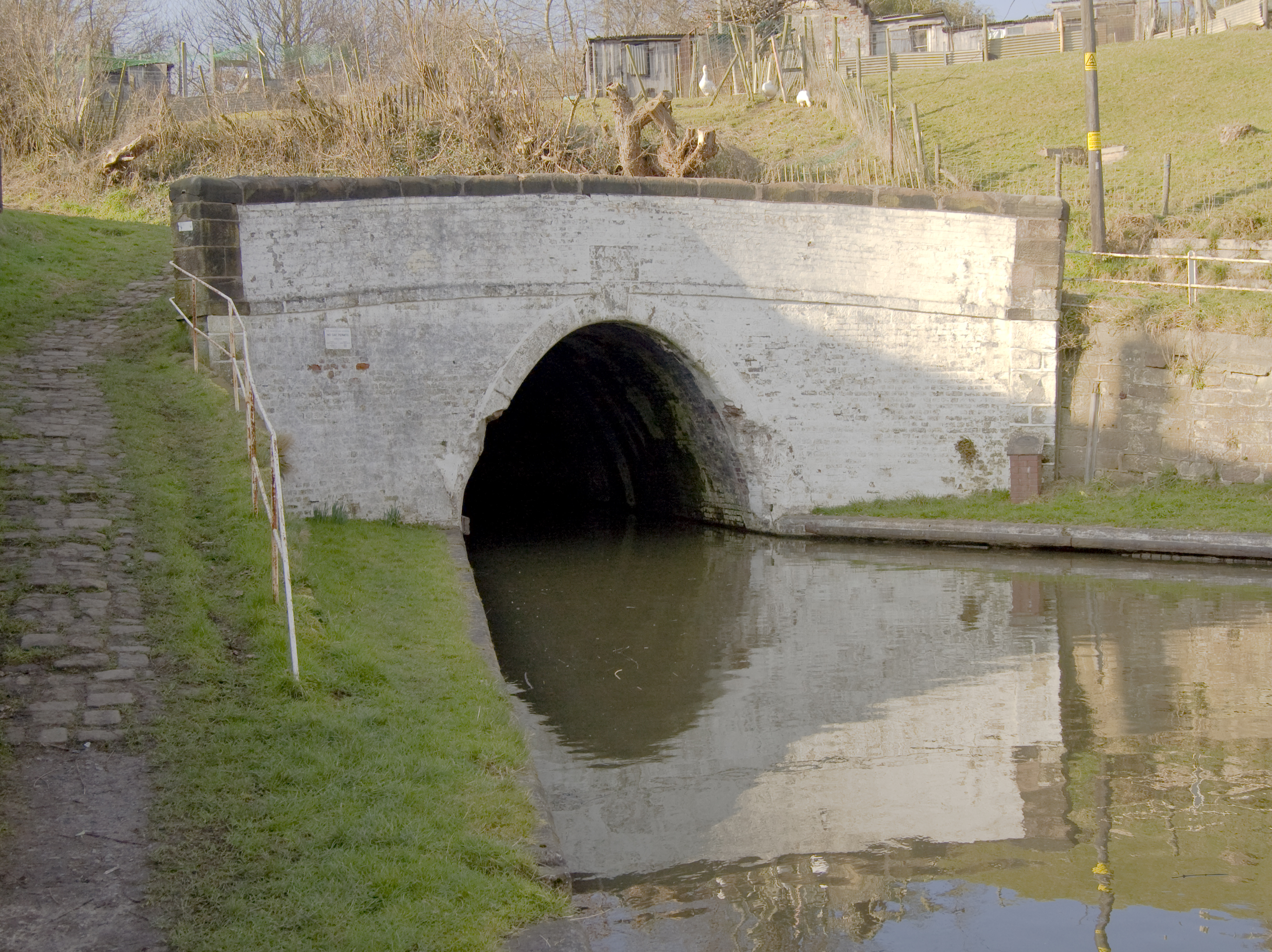
Nature enthusiasts can enjoy the picturesque countryside surrounding Barnton. The village is close to the renowned Delamere Forest, offering opportunities for outdoor activities such as hiking, cycling, and birdwatching. The nearby River Weaver also provides a tranquil setting for leisurely walks and fishing.

Education is well catered for in Barnton, with several primary schools serving the local community. For secondary education, students typically attend schools in nearby Northwich.

Overall, Barnton offers a peaceful and friendly environment, combining its historical heritage with modern conveniences and natural beauty, making it an attractive place to live or visit.

If you have any feedback on the listing, please let us know in the comments section below.

Barnton Images

Images are sourced within 2km of 53.270494/-2.549296 or Grid Reference SJ6374. Thanks to Geograph Open Source API. All images are credited.

Anderton Boat Lift Located near Northwich in Cheshire, the Anderton Boat Lift is one of the greatest monuments to Britain's last canal age and known as the "Cathedral of the Canals". 
Built in 1875 it was the world's first and is currently the UK's only Boat Lift.
(From <span class="nowrap"><a title="http://www.andertonboatlift.co.uk/" rel="nofollow ugc noopener" href="http://www.andertonboatlift.co.uk/">Link</a><img style="margin-left:2px;" alt="External link" title="External link - shift click to open in new window" src="https://s1.geograph.org.uk/img/external.png" width="10" height="10"/></span> )
Anderton Boat Lift
Located near Northwich in Cheshire, the Anderton Boat Lift is one of the greatest monuments to Britain's last canal age and known as the "Cathedral of the Canals". Built in 1875 it was the world's first and is currently the UK's only Boat Lift. (From LinkExternal link )
The Anderton Boat Lift Another view of the boat lift at Barnton near Northwich, taken from the river Weaver.
The Anderton Boat Lift
Another view of the boat lift at Barnton near Northwich, taken from the river Weaver.
At Barnton Tunnel The boat is waiting at the West end of Barnton Tunnel, which is just off left of the picture.
At Barnton Tunnel
The boat is waiting at the West end of Barnton Tunnel, which is just off left of the picture.
Saltersford Tunnel - Eastern portal The alignment of the working boat shows the direction of the tunnel bore.
Saltersford Tunnel - Eastern portal
The alignment of the working boat shows the direction of the tunnel bore.
Lime Avenue shops, Weaverham A neighbourhood group of shops built to serve the estate of council built houses developed in the late 1940's.
Lime Avenue shops, Weaverham
A neighbourhood group of shops built to serve the estate of council built houses developed in the late 1940's.
Owley Wood Owley Wood close to Weaverham a popular recreational area.
Owley Wood
Owley Wood close to Weaverham a popular recreational area.
Winnington works and recreation club, Northwich Cricket match at Winnington recreation club close to the works at Winnington, Northwich once owned by ICI.
Winnington works and recreation club, Northwich
Cricket match at Winnington recreation club close to the works at Winnington, Northwich once owned by ICI.
River Weaver, Cheshire River Weaver as it flows close to Owley Wood
River Weaver, Cheshire
River Weaver as it flows close to Owley Wood
Embankment Embankment close to River Weaver.
Embankment
Embankment close to River Weaver.
Works, close to Moss Farm, Northwich Area of mixed industry this building is at 643737
Works, close to Moss Farm, Northwich
Area of mixed industry this building is at 643737
Works  close to Moss Farm An area of mixed industry.
Works close to Moss Farm
An area of mixed industry.
Potato field close to Owley Wood Cheshire potatoes growing on the edge of the village of Weaverham.
Potato field close to Owley Wood
Cheshire potatoes growing on the edge of the village of Weaverham.
Houses in Owley Wood Houses built and owned by ICI for their workers at the nearby factories at Winnington. Houses now privately owned.
Houses in Owley Wood
Houses built and owned by ICI for their workers at the nearby factories at Winnington. Houses now privately owned.
Anderton Boat Lift Taken after descending in the lift.  This was before the lift was closed for many years and subsequently  heavily overhauled and modified.  Compare with more recent pictures from a similar viewpoint.
Anderton Boat Lift
Taken after descending in the lift. This was before the lift was closed for many years and subsequently heavily overhauled and modified. Compare with more recent pictures from a similar viewpoint.
Anderton Boat Lift from the River Weaver Looking back at the boat lift, again in its previous incarnation
Anderton Boat Lift from the River Weaver
Looking back at the boat lift, again in its previous incarnation
Anderton Boat Lift from the visitor centre Yet another take on this popular attraction
Anderton Boat Lift from the visitor centre
Yet another take on this popular attraction
Winnington works Taken from the swing bridge on the Weaver navigation
Winnington works
Taken from the swing bridge on the Weaver navigation
Anderton boat lift Look carefully and you can see a boat in the kaisson
Anderton boat lift
Look carefully and you can see a boat in the kaisson
Show me another place!

Barnton is located at Grid Ref: SJ6374 (Lat: 53.270494, Lng: -2.549296)

Unitary Authority: Cheshire West and Chester

Police Authority: Cheshire

What 3 Words

///seasons.genius.workbook. Near Weaverham, Cheshire

Nearby Locations

Barnton Cut Barnton

Related Wikis

Christ Church, Barnton

Christ Church is in the village of Barnton, Cheshire, England. It is an active Anglican parish church in the deanery of Great Budworth, the archdeaconry...

Barnton, Cheshire

Barnton is a civil parish and village in the northwest region of England, just outside the town of Northwich, in the unitary authority of Cheshire West...

1874 Northwich F.C.

1874 Northwich Football Club is a football club based in Northwich, Cheshire, England. Established in 2012 by supporters of Northwich Victoria, they are...

Barnton F.C.

Barnton Football Club is a football club in the village of Barnton, near Northwich, in Cheshire. They are currently members of the North West Counties...

Nearby Amenities

Located within 500m of 53.270494,-2.549296
Turning Circle
Lat/Long: 53.2735691/-2.5450898
Turning Circle
Lat/Long: 53.2715908/-2.5522272
Barnton
Place: village
Wikidata: Q2378914
Wikipedia: en:Barnton, Cheshire
Lat/Long: 53.2724821/-2.5458006
Turning Circle
Lat/Long: 53.2711765/-2.5489865
Post Office
Source: GPS survey
Lat/Long: 53.2704478/-2.5489618
Post Box
Postal Code: CW8
Ref: CW8 1
Source: GPS survey
Lat/Long: 53.2704304/-2.548937
Man Made: ventilation_shaft
Lat/Long: 53.2690738/-2.5534019
Bus Stop
Barnton, Runcorn Road / Old Red Lion PH
Bus: yes
Naptan AtcoCode: 0610VR0066
Naptan Bearing: SW
Naptan CommonName: Old Red Lion PH
Naptan Indicator: opp
Naptan Landmark: Old Red Lion PH
Naptan LocalityName: Barnton
Naptan NaptanCode: chwgjpg
Naptan ShortCommonName: Old Red Lion PH
Naptan Street: Runcorn Road
Naptan Verified: no
Public Transport: platform
Source: naptan_import
Lat/Long: 53.2680701/-2.5448485
Bus Stop
Barnton, Runcorn Road / Old Red Lion PH
Bus: yes
Naptan AtcoCode: 0610VR0067
Naptan Bearing: NE
Naptan CommonName: Old Red Lion PH
Naptan Indicator: o/s
Naptan Landmark: Old Red Lion PH
Naptan LocalityName: Barnton
Naptan NaptanCode: chwgjpj
Naptan ShortCommonName: Old Red Lion PH
Naptan Street: Runcorn Road
Naptan Verified: no
Public Transport: platform
Source: naptan_import
Lat/Long: 53.2681986/-2.5449599
Bus Stop
Barnton, Runcorn Road / Manor Drive
Bus: yes
Naptan AtcoCode: 0610VR0068
Naptan Bearing: NW
Naptan CommonName: Manor Drive
Naptan Crossing: Manor Drive
Naptan Indicator: opp
Naptan Landmark: Manor Drive
Naptan LocalityName: Barnton
Naptan NaptanCode: chwgjpm
Naptan ShortCommonName: Manor Drive
Naptan Street: Runcorn Road
Naptan Verified: no
Public Transport: platform
Source: naptan_import
Lat/Long: 53.269411/-2.5476679
Bus Stop
Barnton, Runcorn Road / Post Office
Alt Name: Barnton Post Office
Bus: yes
Naptan AltCommonName: Barnton Post Office
Naptan AtcoCode: 0610VR0069
Naptan Bearing: SE
Naptan CommonName: Post Office
Naptan Crossing: Tunnel Road
Naptan Indicator: nr
Naptan Landmark: Post Office
Naptan LocalityName: Barnton
Naptan NaptanCode: chwgjpt
Naptan ShortCommonName: Barnton Post Office
Naptan Street: Runcorn Road
Naptan Verified: no
Public Transport: platform
Source: naptan_import
Lat/Long: 53.2702767/-2.5485773
Bus Stop
Barnton, Grange Avenue / Emmet Street
Bus: yes
Naptan AtcoCode: 0610VR0070
Naptan Bearing: S
Naptan CommonName: Emmet Street
Naptan Crossing: Emmet Street
Naptan Indicator: cnr
Naptan Landmark: Emmet Street
Naptan LocalityName: Barnton
Naptan NaptanCode: chwgjpw
Naptan ShortCommonName: Emmet Street
Naptan Street: Grange Avenue
Naptan Verified: no
Public Transport: platform
Source: naptan_import
Lat/Long: 53.2725014/-2.5507831
Bus Stop
Barnton, Meadow Drive / School Drive
Bus: yes
Naptan AtcoCode: 0610VR0071
Naptan Bearing: SE
Naptan CommonName: School Drive
Naptan Crossing: School Drive
Naptan Indicator: opp
Naptan Landmark: School Drive
Naptan LocalityName: Barnton
Naptan NaptanCode: chwgjta
Naptan ShortCommonName: School Drive
Naptan Street: Meadow Drive
Naptan Verified: no
Public Transport: platform
Shelter: yes
Source: naptan_import
Lat/Long: 53.274365/-2.5530888
Bus Stop
Barnton, Emmett Street / Barn Owl PH
Bus: yes
Naptan AtcoCode: 0610VR0076
Naptan Bearing: NW
Naptan CommonName: Barn Owl PH
Naptan Crossing: Manor Drive
Naptan Indicator: nr
Naptan Landmark: Manor Drive
Naptan LocalityName: Barnton
Naptan NaptanCode: chwgjtj
Naptan ShortCommonName: Barn Owl PH
Naptan Street: Emmett Street
Naptan Verified: no
Public Transport: platform
Source: naptan_import
Lat/Long: 53.270904/-2.5462941
Bus Stop
Barnton, Manor Drive / Runcorn Road
Bus: yes
Naptan AtcoCode: 0610VR0077
Naptan Bearing: NE
Naptan CommonName: Runcorn Road
Naptan Crossing: Runcorn Road
Naptan Indicator: cnr
Naptan Landmark: Runcorn Road
Naptan LocalityName: Barnton
Naptan NaptanCode: chwgjtm
Naptan ShortCommonName: Runcorn Road
Naptan Street: Manor Drive
Naptan Verified: no
Public Transport: platform
Source: naptan_import
Lat/Long: 53.2695538/-2.5472736
Bus Stop
Barnton, Townfield Lane / Crocus Street
Bus: yes
Naptan AtcoCode: 0610VR19013
Naptan Bearing: SE
Naptan BusStopType: CUS
Naptan CommonName: Crocus Street
Naptan Crossing: Crocus Street
Naptan Indicator: cnr
Naptan Landmark: House number 18
Naptan LocalityName: Barnton
Naptan NaptanCode: chwtdgw
Naptan ShortCommonName: Crocus Street
Naptan Street: Townfield Lane
Naptan Verified: no
Public Transport: platform
Source: naptan_import
Lat/Long: 53.2727752/-2.5466526
Bus Stop
Barnton, Townfield Lane / Crocus Street
Bus: yes
Naptan AtcoCode: 0610VR19014
Naptan Bearing: NW
Naptan BusStopType: CUS
Naptan CommonName: Crocus Street
Naptan Crossing: Crocus Street
Naptan Indicator: opp
Naptan Landmark: House number 17
Naptan LocalityName: Barnton
Naptan NaptanCode: chwtdjd
Naptan ShortCommonName: Crocus Street
Naptan Street: Townfield Lane
Naptan Verified: no
Public Transport: platform
Source: naptan_import
Lat/Long: 53.2726431/-2.5468268
Bus Stop
Barnton, Lydyett Lane / Nursery Road
Bus: yes
Naptan AtcoCode: 0610VR19015
Naptan Bearing: NE
Naptan BusStopType: CUS
Naptan CommonName: Nursery Road
Naptan Crossing: Nursery Road
Naptan Indicator: opp
Naptan Landmark: House number 77
Naptan LocalityName: Barnton
Naptan NaptanCode: chwtdaj
Naptan ShortCommonName: Nursery Road
Naptan Street: Lydyett Lane
Naptan Verified: no
Public Transport: platform
Source: naptan_import
Lat/Long: 53.2726096/-2.5448463
Bus Stop
Barnton, Lydyett Lane / Broadway
Bus: yes
Naptan AtcoCode: 0610VR19016
Naptan Bearing: SW
Naptan BusStopType: CUS
Naptan CommonName: Broadway
Naptan Crossing: Broadway
Naptan Indicator: cnr
Naptan Landmark: House number 54
Naptan LocalityName: Barnton
Naptan NaptanCode: chwtdjp
Naptan ShortCommonName: Broadway
Naptan Street: Lydyett Lane
Naptan Verified: no
Public Transport: platform
Source: naptan_import
Lat/Long: 53.2724933/-2.5447248
Bus Stop
Barnton, Grange Avenue / Grange Road
Bus: yes
Naptan AtcoCode: 0610VR19020
Naptan Bearing: N
Naptan CommonName: Grange Road
Naptan Crossing: Grange Road
Naptan Indicator: cnr
Naptan Landmark: House number 5
Naptan LocalityName: Barnton
Naptan NaptanCode: chwtdmd
Naptan ShortCommonName: Grange Road
Naptan Street: Grange Avenue
Naptan Verified: no
Public Transport: platform
Source: naptan_import
Lat/Long: 53.2715844/-2.5508013
Bus Stop
Barnton, Runcorn Road / Oakwood Lane
Bus: yes
Naptan AtcoCode: 0610VR213
Naptan Bearing: NW
Naptan CommonName: Oakwood Lane
Naptan Crossing: Oakwood Lane
Naptan Indicator: opp
Naptan Landmark: House number 165
Naptan LocalityName: Barnton
Naptan NaptanCode: chwapdm
Naptan ShortCommonName: Oakwood Lane
Naptan Street: Runcorn Road
Naptan Verified: no
Public Transport: platform
Source: naptan_import
Lat/Long: 53.2709892/-2.5531629
Noexit: yes
Lat/Long: 53.2693053/-2.5490436
Atm
Lat/Long: 53.2721746/-2.5455256
Entrance: yes
Lat/Long: 53.2721532/-2.5455672
Entrance: yes
Lat/Long: 53.2684857/-2.5443822
Cafe
The Penny Farthing Tearoom
Addr Housenumber: 6
Addr Postcode: CW8 4EL
Addr Street: Runcorn Road
Fhrs Id: 1271122
Source Addr: FHRS Open Data
Website: http://www.northwichauction.co.uk/pennyfarthingtearoom.htm
Lat/Long: 53.2684795/-2.5443304
Turning Circle
Lat/Long: 53.2731421/-2.5487427
Turning Circle
Lat/Long: 53.273479/-2.5462398
Generator Method: photovoltaic
Generator Output Electricity: yes
Generator Source: solar
Generator Type: solar_photovoltaic_panel
Location: roof
Power: generator
Lat/Long: 53.2693742/-2.5463176
Generator Method: photovoltaic
Generator Output Electricity: yes
Generator Source: solar
Generator Type: solar_photovoltaic_panel
Location: roof
Power: generator
Lat/Long: 53.270072/-2.5460333
Generator Method: photovoltaic
Generator Output Electricity: yes
Generator Source: solar
Generator Type: solar_photovoltaic_panel
Location: roof
Power: generator
Lat/Long: 53.2701923/-2.546677
Generator Method: photovoltaic
Generator Output Electricity: yes
Generator Source: solar
Generator Type: solar_photovoltaic_panel
Location: roof
Power: generator
Lat/Long: 53.2739168/-2.5528917
Generator Method: photovoltaic
Generator Output Electricity: yes
Generator Source: solar
Generator Type: solar_photovoltaic_panel
Location: roof
Power: generator
Lat/Long: 53.2737018/-2.5449362
Generator Method: photovoltaic
Generator Output Electricity: yes
Generator Source: solar
Generator Type: solar_photovoltaic_panel
Location: roof
Power: generator
Lat/Long: 53.2693148/-2.5501853
Generator Method: photovoltaic
Generator Output Electricity: yes
Generator Source: solar
Generator Type: solar_photovoltaic_panel
Location: roof
Power: generator
Lat/Long: 53.2694191/-2.5521943
Generator Method: photovoltaic
Generator Output Electricity: yes
Generator Source: solar
Generator Type: solar_photovoltaic_panel
Location: roof
Power: generator
Lat/Long: 53.26944/-2.5515077
Generator Method: photovoltaic
Generator Output Electricity: yes
Generator Source: solar
Generator Type: solar_photovoltaic_panel
Location: roof
Power: generator
Lat/Long: 53.2699196/-2.5508907
Generator Method: photovoltaic
Generator Output Electricity: yes
Generator Source: solar
Generator Type: solar_photovoltaic_panel
Location: roof
Power: generator
Lat/Long: 53.2699132/-2.5508076
Generator Method: photovoltaic
Generator Output Electricity: yes
Generator Source: solar
Generator Type: solar_photovoltaic_panel
Location: roof
Power: generator
Lat/Long: 53.2697864/-2.5506681
Generator Method: photovoltaic
Generator Output Electricity: yes
Generator Source: solar
Generator Type: solar_photovoltaic_panel
Location: roof
Power: generator
Lat/Long: 53.2704329/-2.550754
Generator Method: photovoltaic
Generator Output Electricity: yes
Generator Source: solar
Generator Type: solar_photovoltaic_panel
Location: roof
Power: generator
Lat/Long: 53.2704906/-2.5509846
Generator Method: photovoltaic
Generator Output Electricity: yes
Generator Source: solar
Generator Type: solar_photovoltaic_panel
Location: roof
Power: generator
Lat/Long: 53.2717594/-2.5534308
Generator Method: photovoltaic
Generator Output Electricity: yes
Generator Source: solar
Generator Type: solar_photovoltaic_panel
Location: roof
Power: generator
Lat/Long: 53.2717739/-2.5533262
Generator Method: photovoltaic
Generator Output Electricity: yes
Generator Source: solar
Generator Type: solar_photovoltaic_panel
Location: roof
Power: generator
Lat/Long: 53.2717578/-2.5532296
Generator Method: photovoltaic
Generator Output Electricity: yes
Generator Source: solar
Generator Type: solar_photovoltaic_panel
Location: roof
Power: generator
Lat/Long: 53.2717193/-2.553125
Generator Method: photovoltaic
Generator Output Electricity: yes
Generator Source: solar
Generator Type: solar_photovoltaic_panel
Location: roof
Power: generator
Lat/Long: 53.2719391/-2.5513735
Generator Method: photovoltaic
Generator Output Electricity: yes
Generator Source: solar
Generator Type: solar_photovoltaic_panel
Location: roof
Power: generator
Lat/Long: 53.2720947/-2.5519234
Generator Method: photovoltaic
Generator Output Electricity: yes
Generator Source: solar
Generator Type: solar_photovoltaic_panel
Location: roof
Power: generator
Lat/Long: 53.2726111/-2.5543132
Generator Method: photovoltaic
Generator Output Electricity: yes
Generator Source: solar
Generator Type: solar_photovoltaic_panel
Location: roof
Power: generator
Lat/Long: 53.2725502/-2.5542408
Generator Method: photovoltaic
Generator Output Electricity: yes
Generator Source: solar
Generator Type: solar_photovoltaic_panel
Location: roof
Power: generator
Lat/Long: 53.2724844/-2.5541469
Generator Method: photovoltaic
Generator Output Electricity: yes
Generator Source: solar
Generator Type: solar_photovoltaic_panel
Location: roof
Power: generator
Lat/Long: 53.272292/-2.5536454
Generator Method: photovoltaic
Generator Output Electricity: yes
Generator Source: solar
Generator Type: solar_photovoltaic_panel
Location: roof
Power: generator
Lat/Long: 53.2731485/-2.5523311
Generator Method: photovoltaic
Generator Output Electricity: yes
Generator Source: solar
Generator Type: solar_photovoltaic_panel
Location: roof
Power: generator
Lat/Long: 53.2732014/-2.5524277
Generator Method: photovoltaic
Generator Output Electricity: yes
Generator Source: solar
Generator Type: solar_photovoltaic_panel
Location: roof
Power: generator
Lat/Long: 53.2735447/-2.5532725
Generator Method: photovoltaic
Generator Output Electricity: yes
Generator Source: solar
Generator Type: solar_photovoltaic_panel
Location: roof
Power: generator
Lat/Long: 53.2734404/-2.5533906
Generator Method: photovoltaic
Generator Output Electricity: yes
Generator Source: solar
Generator Type: solar_photovoltaic_panel
Location: roof
Power: generator
Lat/Long: 53.2734051/-2.553463
Generator Method: photovoltaic
Generator Output Electricity: yes
Generator Source: solar
Generator Type: solar_photovoltaic_panel
Location: roof
Power: generator
Lat/Long: 53.2732463/-2.5550669
Man Made: ventilation_shaft
Lat/Long: 53.2687855/-2.5507432
Playground: swing
Lat/Long: 53.2720602/-2.5560838
Playground: swing
Lat/Long: 53.2719483/-2.5562735
Leisure: pitch
Sport: soccer
Lat/Long: 53.2720545/-2.5563037
Noexit: yes
Lat/Long: 53.2702533/-2.5516945
Crossing
Crossing: traffic_signals
Crossing Island: no
Crossing Ref: pelican
Tactile Paving: yes
Lat/Long: 53.2705605/-2.5493807
Post Box
Post Box Type: pillar
Ref: CW8 42D
Royal Cypher: GR
Lat/Long: 53.2723381/-2.5451361
Telephone
Booth: KX100
Covered: booth
Phone: +44160675090
Lat/Long: 53.2723208/-2.5451387
Grit Bin
Lat/Long: 53.2739252/-2.5523606
Give Way
Direction: forward
Lat/Long: 53.271593/-2.5431807
Give Way
Direction: backward
Lat/Long: 53.27154/-2.5432334
The data included in this document is from www.openstreetmap.org. The data is made available under ODbL.

Have you been to Barnton?

Leave your review of Barnton below (or comments, questions and feedback).