Lacey Green

Settlement in Surrey

England

Lacey Green

Coulsdon : signpost, Farthing Down
Coulsdon : signpost, Farthing Down Credit: Jim Osley

Lacey Green is a small village located in the county of Surrey in southeastern England. It is situated about 30 miles west of central London, making it a popular residential area for those who work in the city but prefer a quieter countryside lifestyle.

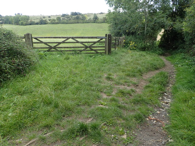
The village is nestled in the Chiltern Hills, an Area of Outstanding Natural Beauty, and offers stunning views of the surrounding countryside. Lacey Green is renowned for its picturesque landscapes, with rolling hills, lush meadows, and charming woodland areas.

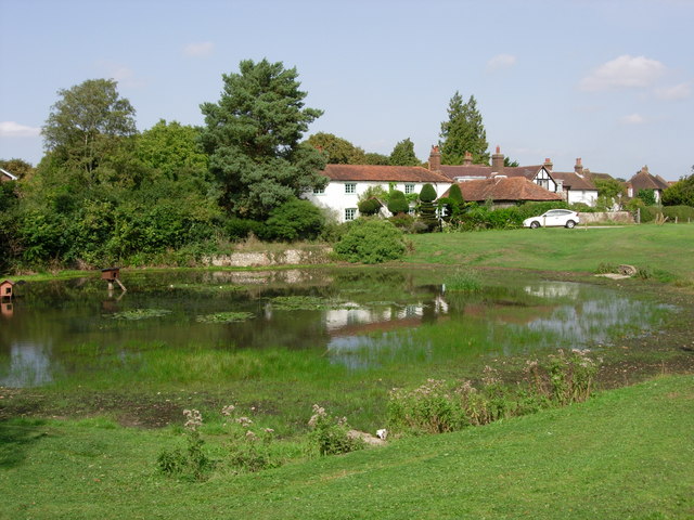
Historically, the village was an agricultural settlement, and evidence of its rural past can still be seen in the form of traditional cottages and farmhouses that dot the area. However, in recent years, Lacey Green has experienced some residential development, with modern houses and amenities being introduced to accommodate the growing population.

Despite its small size, Lacey Green is a vibrant and close-knit community. It boasts a primary school, a village hall, a local pub, and a cricket club, providing residents with a range of social and recreational activities. The village also hosts various events throughout the year, including a popular annual fete that brings together locals and visitors alike.

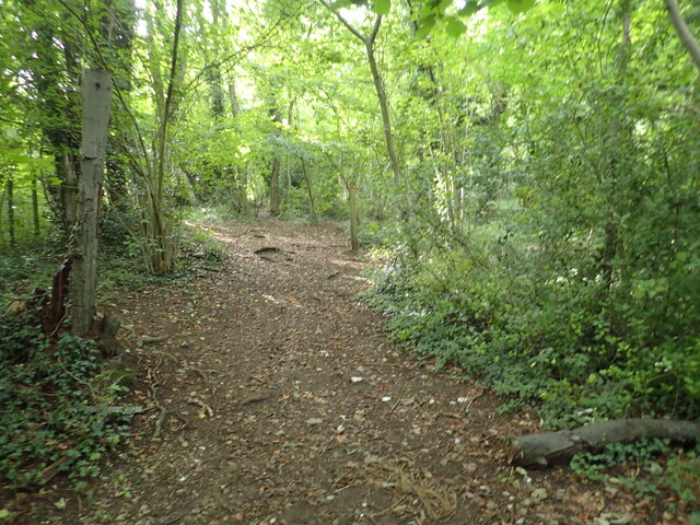
For those seeking outdoor pursuits, Lacey Green offers numerous walking trails and bridleways, allowing residents to explore the stunning countryside that surrounds them. Additionally, the village is within close proximity to other attractions, such as the historic town of High Wycombe and the popular Hellfire Caves.

Overall, Lacey Green is a charming and idyllic village that offers a peaceful and picturesque setting, making it an attractive place to live or visit for those seeking a tranquil rural retreat within easy reach of the bustling city of London.

If you have any feedback on the listing, please let us know in the comments section below.

Lacey Green Images

Images are sourced within 2km of 51.301028/-0.120821 or Grid Reference TQ3157. Thanks to Geograph Open Source API. All images are credited.

Coulsdon : signpost, Farthing Down
Netherne-on-the-Hill : water tower Former water tower built as part of the former Netherne Mental Hospital. History of the site at this <span class="nowrap"><a title="https://www.thetimechamber.co.uk/beta/sites/asylums/surrey-country-asylum-netherne-hospital" rel="nofollow ugc noopener" href="https://www.thetimechamber.co.uk/beta/sites/asylums/surrey-country-asylum-netherne-hospital">Link</a><img style="margin-left:2px;" alt="External link" title="External link - shift click to open in new window" src="https://s1.geograph.org.uk/img/external.png" width="10" height="10"/></span>. Architect: George Thomas Hine
Netherne-on-the-Hill : water tower
Former water tower built as part of the former Netherne Mental Hospital. History of the site at this LinkExternal link. Architect: George Thomas Hine
Netherne-on-the-Hill : detail, water-tower Former water tower built as part of the former Netherne Mental Hospital. History of the site at this <span class="nowrap"><a title="https://www.thetimechamber.co.uk/beta/sites/asylums/surrey-country-asylum-netherne-hospital" rel="nofollow ugc noopener" href="https://www.thetimechamber.co.uk/beta/sites/asylums/surrey-country-asylum-netherne-hospital">Link</a><img style="margin-left:2px;" alt="External link" title="External link - shift click to open in new window" src="https://s1.geograph.org.uk/img/external.png" width="10" height="10"/></span>. Architect: George Thomas Hine
Netherne-on-the-Hill : detail, water-tower
Former water tower built as part of the former Netherne Mental Hospital. History of the site at this LinkExternal link. Architect: George Thomas Hine
Farthing Downs View towards Cane Hill and the housing development which stands on the site of the former mental asylum. The chapel, administration block, and water tower have been retained within the development.
Farthing Downs
View towards Cane Hill and the housing development which stands on the site of the former mental asylum. The chapel, administration block, and water tower have been retained within the development.
Farthing Downs A path which runs parallel to the road. By the time the trees are reached, views towards Croydon and London open up.
Farthing Downs
A path which runs parallel to the road. By the time the trees are reached, views towards Croydon and London open up.
Farthing Downs View towards Cane Hill and the housing development which stands on the site of the former mental asylum. The chapel, administration block, and water tower have been retained within the development.
Farthing Downs
View towards Cane Hill and the housing development which stands on the site of the former mental asylum. The chapel, administration block, and water tower have been retained within the development.
Looking towards Farthing Downs This view is from a field next to Drive Road which is actually a footpath here. This field is part of the Corporation of London owned land but is not part of Farthing Downs which is beyond the second field in the distance.

This remote-looking countryside is actually in the London Borough of Croydon.
Looking towards Farthing Downs
This view is from a field next to Drive Road which is actually a footpath here. This field is part of the Corporation of London owned land but is not part of Farthing Downs which is beyond the second field in the distance. This remote-looking countryside is actually in the London Borough of Croydon.
Footpath through Boxers Wood The path passes through the eastern side of Boxers Wood before emerging to follow the edge of a field and meet the wider path known as Drive Road.
Footpath through Boxers Wood
The path passes through the eastern side of Boxers Wood before emerging to follow the edge of a field and meet the wider path known as Drive Road.
The London Loop on Farthing Downs This is on the London Loop as it heads across Farthing Downs. The Downs are a fine area of chalk grassland and are owned and managed by the Corporation of London. For more about Farthing Downs see <span class="nowrap"><a title="https://en.wikipedia.org/wiki/Farthing_Downs" rel="nofollow ugc noopener" href="https://en.wikipedia.org/wiki/Farthing_Downs">Link</a><img style="margin-left:2px;" alt="External link" title="External link - shift click to open in new window" src="https://s1.geograph.org.uk/img/external.png" width="10" height="10"/></span>
The London Loop on Farthing Downs
This is on the London Loop as it heads across Farthing Downs. The Downs are a fine area of chalk grassland and are owned and managed by the Corporation of London. For more about Farthing Downs see LinkExternal link
The London Loop on Farthing Downs This is on the London Loop as it heads across Farthing Downs looking back towards Coulsdon. The Downs are a fine area of chalk grassland and are owned and managed by the Corporation of London. For more about Farthing Downs see <span class="nowrap"><a title="https://en.wikipedia.org/wiki/Farthing_Downs" rel="nofollow ugc noopener" href="https://en.wikipedia.org/wiki/Farthing_Downs">Link</a><img style="margin-left:2px;" alt="External link" title="External link - shift click to open in new window" src="https://s1.geograph.org.uk/img/external.png" width="10" height="10"/></span>
The London Loop on Farthing Downs
This is on the London Loop as it heads across Farthing Downs looking back towards Coulsdon. The Downs are a fine area of chalk grassland and are owned and managed by the Corporation of London. For more about Farthing Downs see LinkExternal link
Information about the Saxon Burial Mounds on Farthing Downs This information board is by these trees <a title="www.geograph.org.uk/photo/7586746" href="https://www.geograph.org.uk/photo/7586746">Link</a>  and the mounds are to the north and south as shown on the aerial view. The London Loop passes by here.
Information about the Saxon Burial Mounds on Farthing Downs
This information board is by these trees Link and the mounds are to the north and south as shown on the aerial view. The London Loop passes by here.
The London Loop on Farthing Downs This is on the London Loop as it heads across Farthing Downs looking back towards Coulsdon. The Downs are a fine area of chalk grassland and are owned and managed by the Corporation of London. For more about Farthing Downs see <span class="nowrap"><a title="https://en.wikipedia.org/wiki/Farthing_Downs" rel="nofollow ugc noopener" href="https://en.wikipedia.org/wiki/Farthing_Downs">Link</a><img style="margin-left:2px;" alt="External link" title="External link - shift click to open in new window" src="https://s1.geograph.org.uk/img/external.png" width="10" height="10"/></span>
The London Loop on Farthing Downs
This is on the London Loop as it heads across Farthing Downs looking back towards Coulsdon. The Downs are a fine area of chalk grassland and are owned and managed by the Corporation of London. For more about Farthing Downs see LinkExternal link
Signpost on Farthing Downs This is seen from the London Loop as it heads across Farthing Downs, looking here in the direction of Downs Road and Chipstead. Farthing Downs are a fine area of chalk grassland and are owned and managed by the Corporation of London. 

For more about Farthing Downs see <span class="nowrap"><a title="https://en.wikipedia.org/wiki/Farthing_Downs" rel="nofollow ugc noopener" href="https://en.wikipedia.org/wiki/Farthing_Downs">Link</a><img style="margin-left:2px;" alt="External link" title="External link - shift click to open in new window" src="https://s1.geograph.org.uk/img/external.png" width="10" height="10"/></span>
Signpost on Farthing Downs
This is seen from the London Loop as it heads across Farthing Downs, looking here in the direction of Downs Road and Chipstead. Farthing Downs are a fine area of chalk grassland and are owned and managed by the Corporation of London. For more about Farthing Downs see LinkExternal link
The London Loop on Farthing Downs This is on the London Loop as it heads across Farthing Downs looking back towards Coulsdon. The Downs are a fine area of chalk grassland and are owned and managed by the Corporation of London. 

For more about Farthing Downs see <span class="nowrap"><a title="https://en.wikipedia.org/wiki/Farthing_Downs" rel="nofollow ugc noopener" href="https://en.wikipedia.org/wiki/Farthing_Downs">Link</a><img style="margin-left:2px;" alt="External link" title="External link - shift click to open in new window" src="https://s1.geograph.org.uk/img/external.png" width="10" height="10"/></span>
The London Loop on Farthing Downs
This is on the London Loop as it heads across Farthing Downs looking back towards Coulsdon. The Downs are a fine area of chalk grassland and are owned and managed by the Corporation of London. For more about Farthing Downs see LinkExternal link
The London Loop on Farthing Downs This is on the London Loop as it heads across Farthing Downs from Coulsdon. The Downs are a fine area of chalk grassland and are owned and managed by the Corporation of London. 

For more about Farthing Downs see <span class="nowrap"><a title="https://en.wikipedia.org/wiki/Farthing_Downs" rel="nofollow ugc noopener" href="https://en.wikipedia.org/wiki/Farthing_Downs">Link</a><img style="margin-left:2px;" alt="External link" title="External link - shift click to open in new window" src="https://s1.geograph.org.uk/img/external.png" width="10" height="10"/></span>
The London Loop on Farthing Downs
This is on the London Loop as it heads across Farthing Downs from Coulsdon. The Downs are a fine area of chalk grassland and are owned and managed by the Corporation of London. For more about Farthing Downs see LinkExternal link
View near Boxers Wood This view is from the footpath between Ditches Lane and Tugswood Close at Netherne-On-The-Hill just as Boxers Wood is reached.
View near Boxers Wood
This view is from the footpath between Ditches Lane and Tugswood Close at Netherne-On-The-Hill just as Boxers Wood is reached.
Footpath through Boxers Wood This view is of the footpath between Ditches Lane and Tugswood Close at Netherne-On-The-Hill as it passes through Boxers Wood.
Footpath through Boxers Wood
This view is of the footpath between Ditches Lane and Tugswood Close at Netherne-On-The-Hill as it passes through Boxers Wood.
Drive Road near Farthing Downs This is where a footpath from Boxers Wood joins Drive Road. It looks along Drive Road as it heads up to Farthing Downs which is on the far side of the field on the left.
Drive Road near Farthing Downs
This is where a footpath from Boxers Wood joins Drive Road. It looks along Drive Road as it heads up to Farthing Downs which is on the far side of the field on the left.
Show me another place!

Lacey Green is located at Grid Ref: TQ3157 (Lat: 51.301028, Lng: -0.120821)

Unitary Authority: Croydon

Police Authority: Metropolitan

What 3 Words

///leaned.steep.cult. Near Whyteleafe, Surrey

Related Wikis

Old Coulsdon

Old Coulsdon is a village near Coulsdon in the London Borough of Croydon, England, 14.4 miles (23 km) south of Charing Cross. It is the southernmost settlement...

Purley High School for Boys

Purley High School for Boys existed from 1914 to 1988. Originally located in Purley from 1914, in 1936 it relocated to Placehouse Lane, Old Coulsdon, London...

Coulsdon East (ward)

Coulsdon East was a ward in the London Borough of Croydon, covering part of the Coulsdon area of London in the United Kingdom. The ward formed part of...

Old Coulsdon (ward)

Old Coulsdon is a ward in the London Borough of Croydon, covering part of the Coulsdon area of London in the United Kingdom. The ward currently forms part...

Nearby Amenities

Located within 500m of 51.301028,-0.120821
Source: Personal memory
Traffic Sign: low_emission_zone
Lat/Long: 51.2990117/-0.1156131
Source: Personal memory
Traffic Sign: low_emission_zone
Lat/Long: 51.300896/-0.117184
Turning Circle
Lat/Long: 51.2990637/-0.1268317
Bus Stop
Keston Avenue
Bus: yes
Local Ref: P
Naptan AtcoCode: 490005649E
Naptan Bearing: E
Naptan CommonName: Keston Avenue
Naptan Indicator: Stop P
Naptan Street: KESTON AVENUE
Naptan Verified: no
Public Transport: platform
Ref: 57341
Lat/Long: 51.3039903/-0.1160416
Bus Stop
Keston Avenue
Bus: yes
Local Ref: U
Naptan AtcoCode: 490005649W
Naptan Bearing: W
Naptan CommonName: Keston Avenue
Naptan Indicator: Stop U
Naptan Street: KESTON AVENUE
Naptan Verified: no
Public Transport: platform
Ref: 57725
Lat/Long: 51.3038796/-0.116106
Bus Stop
Waddington Avenue / Homefield Road
Bus: yes
Local Ref: S
Naptan AtcoCode: 490008324S
Naptan Bearing: S
Naptan CommonName: Homefield Road
Naptan Indicator: Stop S
Naptan Street: WADDINGTON AVENUE
Naptan Verified: no
Public Transport: platform
Ref: 47157
Lat/Long: 51.3019685/-0.1138469
Bus Stop
Lacey Drive
Bus: yes
Naptan AtcoCode: 490008495E
Naptan Bearing: N
Naptan CommonName: Inwood Avenue
Naptan Street: LACEY DRIVE
Naptan Verified: no
Public Transport: platform
Ref: 71478
Lat/Long: 51.2994324/-0.1146104
Bus Stop
Coulsdon Road / Lacey Drive
Bus: yes
Naptan AtcoCode: 490008895N
Naptan Bearing: N
Naptan CommonName: Coulsdon Road Lacey Drive
Naptan Street: COULSDON ROAD
Naptan Verified: yes
Public Transport: platform
Ref: 58016
Lat/Long: 51.2986741/-0.1154004
Bus Stop
Coulsdon Road / Lacey Drive
Bus: yes
Naptan AtcoCode: 490008895S
Naptan Bearing: N
Naptan CommonName: Coulsdon Road Lacey Drive
Naptan Street: COULSDON ROAD
Naptan Verified: yes
Public Transport: platform
Ref: 55790
Lat/Long: 51.2993452/-0.1160441
Bus Stop
Lacey Drive
Bus: yes
Naptan AtcoCode: 490008895W
Naptan Bearing: W
Naptan CommonName: Coulsdon Road Lacey Drive
Naptan Street: LACEY DRIVE
Naptan Verified: no
Public Transport: platform
Ref: 76343
Lat/Long: 51.2992714/-0.1147116
Bus Stop
Taunton Lane
Bus: yes
Local Ref: A
Naptan AtcoCode: 490013168N
Naptan Bearing: N
Naptan CommonName: Taunton Lane
Naptan Indicator: Stop A
Naptan Street: COULSDON ROAD
Naptan Verified: no
Public Transport: platform
Ref: 52874
Lat/Long: 51.301332/-0.118018
Bus Stop
Taunton Lane
Bus: yes
Local Ref: K
Naptan AtcoCode: 490013168S
Naptan Bearing: S
Naptan CommonName: Taunton Lane
Naptan Indicator: Stop K
Naptan Street: COULSDON ROAD
Naptan Verified: no
Public Transport: platform
Ref: 49771
Lat/Long: 51.3025519/-0.1182296
Bus Stop
Homefield Road
Bus: yes
Naptan AtcoCode: 490014107E
Naptan Bearing: E
Naptan CommonName: Waddington Avenue Homefield Rd
Naptan Street: HOMEFIELD ROAD
Naptan Verified: no
Public Transport: platform
Ref: 58760
Lat/Long: 51.3008544/-0.11403
Bus Stop
Homefield Road
Bus: yes
Naptan AtcoCode: 490014107N
Naptan Bearing: N
Naptan CommonName: Waddington Avenue Homefield Rd
Naptan Street: HOMEFIELD ROAD
Naptan Verified: no
Public Transport: platform
Ref: 75223
Lat/Long: 51.3006283/-0.1141183
Bus Stop
Tollers Lane / The Crossways
Bus: yes
Naptan AtcoCode: 490013689S
Naptan Bearing: S
Naptan CommonName: Tollers Lane The Crossways
Naptan Street: TOLLERS LANE
Naptan Verified: no
Public Transport: platform
Ref: 73095
Lat/Long: 51.3034362/-0.1234319
Bus Stop
The Crossways
Bus: yes
Local Ref: M
Naptan AtcoCode: 490015542S1
Naptan Bearing: S
Naptan CommonName: Thornton Crescent
Naptan Indicator: Stop M
Naptan Street: THE CROSSWAYS
Naptan Verified: no
Public Transport: platform
Ref: 56523
Lat/Long: 51.3038329/-0.1189834
Bus Stop
The Crossways
Bus: yes
Local Ref: B
Naptan AtcoCode: 490013317N
Naptan Bearing: N
Naptan CommonName: The Crossways Coulsdon Road
Naptan Indicator: Stop B
Naptan Street: COULSDON ROAD
Naptan Verified: no
Public Transport: platform
Ref: 72004
Lat/Long: 51.3047706/-0.1188106
Bus Stop
The Crossways
Bus: yes
Local Ref: J
Naptan AtcoCode: 490013317S2
Naptan Bearing: S
Naptan CommonName: The Crossways Coulsdon Road
Naptan Indicator: Stop J
Naptan Street: COULSDON ROAD
Naptan Verified: no
Public Transport: platform
Ref: 48521
Lat/Long: 51.30415/-0.1185885
Place Of Worship
St Mary, Help of Christians Church
Addr City: Coulsdon
Addr Housenumber: 372
Addr Postcode: CR5 1EF
Addr Street: Coulsdon Road
Addr Village: Old Coulsdon
Denomination: catholic
Email: priest@stmaryscoulsdon.co.uk
Phone: +44 1737 552420
Religion: christian
Service Times: Mo-We, Fr 10:00; Sa 18:30; Su 08:00, 10:45; Th off
Source: OS Street View;local knowledge
Website: http://www.stmaryscoulsdon.co.uk
Lat/Long: 51.3027268/-0.118843
Source: Personal memory
Traffic Sign: low_emission_zone
Lat/Long: 51.3028871/-0.1183058
Barrier: kissing_gate
Lat/Long: 51.3019574/-0.1240881
Fixme: continue
Lat/Long: 51.3020182/-0.1247406
Barrier: lift_gate
Lat/Long: 51.2983364/-0.116438
Fixme: continue
Lat/Long: 51.3045111/-0.1250671
Bench
Backrest: yes
Lat/Long: 51.2971591/-0.1233454
Bench
Backrest: no
Source: gps
Lat/Long: 51.2973715/-0.1250139
Bench
Backrest: no
Lat/Long: 51.2970845/-0.1200986
Post Box
Collection Times: Mo-Fr 09:00; Sa 07:00; Su off
Drive Through: no
Operator: Royal Mail
Operator Wikidata: Q638098
Post Box Type: pillar
Ref: CR5 464
Royal Cypher: GVIR
Royal Cypher Wikidata: Q33102169
Source: survey;local knowledge;aerial imagery;streetlevel imagery
Lat/Long: 51.3000677/-0.1229326
Post Box
Collection Times: Mo-Fr 09:00; Sa 07:00; Su off
Drive Through: no
Operator: Royal Mail
Operator Wikidata: Q638098
Post Box Type: pillar
Ref: CR5 444
Royal Cypher: GVIR
Royal Cypher Wikidata: Q33102169
Source: survey
Lat/Long: 51.3032469/-0.1223085
Post Box
Collection Times: Mo-Fr 16:00; Sa 11:30; Su off
Drive Through: no
Operator: Royal Mail
Operator Wikidata: Q638098
Post Box Type: pillar
Ref: CR5 108
Royal Cypher: GR
Royal Cypher Wikidata: Q33102273
Source: survey
Lat/Long: 51.300428/-0.1171956
Post Box
Collection Times: Mo-Fr 16:15; Sa 11:30; Su off
Drive Through: no
Operator: Royal Mail
Operator Wikidata: Q638098
Post Box Type: pillar
Ref: CR5 453
Royal Cypher: GR
Royal Cypher Wikidata: Q33102273
Source: survey
Lat/Long: 51.3038693/-0.1162084
Coulsdon Furniture
Addr City: Coulsdon
Addr Housenumber: 1
Addr Parentstreet: Coulsdon Road
Addr Postcode: CR5 1EN
Addr Street: Lacey Green Parade
Shop: furniture
Lat/Long: 51.3006993/-0.1173578
Londis
Addr City: Coulsdon
Addr Housenumber: 2
Addr Parentstreet: Coulsdon Road
Addr Postcode: CR5 1EN
Addr Street: Lacey Green Parade
Brand: Londis
Brand Wikidata: Q21008564
Fhrs Authority: Croydon
Fhrs Id: 1967
Shop: convenience
Lat/Long: 51.300659/-0.1173176
Pharmacy
Old Coulsdon Pharmacy
Addr City: Coulsdon
Addr Housenumber: 217
Addr Postcode: CR5 1EN
Addr Street: Coulsdon Road
Dispensing: yes
Healthcare: pharmacy
Lat/Long: 51.3005699/-0.1172335
Betfred
Addr City: Coulsdon
Addr Housenumber: 219
Addr Postcode: CR5 1EN
Addr Street: Coulsdon Road
Brand: Betfred
Brand Wikidata: Q4897425
Brand Wikipedia: en:Betfred
Shop: bookmaker
Lat/Long: 51.3005221/-0.1171945
Hooks Dusk Til Dawn
Addr City: Coulsdon
Addr Housenumber: 221
Addr Postcode: CR5 1EN
Addr Street: Coulsdon Road
Fhrs Authority: Croydon
Fhrs Id: 1970
Shop: alcohol
Lat/Long: 51.3004722/-0.117153
Five Star Dry Cleaners
Addr City: Coulsdon
Addr Housenumber: 223
Addr Postcode: CR5 1EN
Addr Street: Coulsdon Road
Shop: dry_cleaning
Lat/Long: 51.3004303/-0.1171163
Cafe
Cafe Shack
Addr City: Coulsdon
Addr Housenumber: 225
Addr Postcode: CR5 1EN
Addr Street: Coulsdon Road
Fhrs Authority: Croydon
Fhrs Id: 22031
Lat/Long: 51.3003456/-0.1170318
Admire
Addr City: Coulsdon
Addr Housenumber: 227
Addr Postcode: CR5 1EN
Addr Street: Coulsdon Road
Shop: hairdresser
Lat/Long: 51.3003007/-0.1169919
KM Barbers
Addr City: Coulsdon
Addr Housenumber: 229
Addr Postcode: CR5 1EN
Addr Street: Coulsdon Road
Shop: hairdresser
Lat/Long: 51.3002528/-0.1169488
S&S Hardware
Addr City: Coulsdon
Addr Housenumber: 231
Addr Postcode: CR5 1EN
Addr Street: Coulsdon Road
Shop: hardware
Lat/Long: 51.300208/-0.1169074
Addr City: Coulsdon
Addr Housenumber: 1
Addr Postcode: CR5 1BR
Addr Street: The Admiral's Walk
Source: survey;code-point open
Lat/Long: 51.2986051/-0.1258239
Addr City: Coulsdon
Addr Housenumber: 4
Addr Postcode: CR5 1BR
Addr Street: The Admiral's Walk
Lat/Long: 51.2985162/-0.1262028
Addr City: Coulsdon
Addr Housenumber: 5
Addr Postcode: CR5 1BR
Addr Street: The Admiral's Walk
Lat/Long: 51.298586/-0.1264036
Addr City: Coulsdon
Addr Housenumber: 10
Addr Postcode: CR5 1BR
Addr Street: The Admiral's Walk
Lat/Long: 51.2988709/-0.1267306
Addr City: Coulsdon
Addr Housename: Ramblers End
Addr Housenumber: 286
Addr Postcode: CR5 1EB
Addr Street: Coulsdon Road
Source: survey;codepoint-open
Lat/Long: 51.3053681/-0.1191734
Addr City: Coulsdon
Addr Housenumber: 300
Addr Postcode: CR5 1EB
Addr Street: Coulsdon Road
Source: survey;codepoint-open
Lat/Long: 51.3048224/-0.1190589
Dentist
Crossways Dental
Addr City: Coulsdon
Addr Housenumber: 328
Addr Postcode: CR5 1EB
Addr Street: Coulsdon Road
Healthcare: dentist
Source: survey;codepoint-open
Lat/Long: 51.3039024/-0.1189552
Addr City: Coulsdon
Addr Housenumber: 336
Addr Postcode: CR5 1EB
Addr Street: Coulsdon Road
Source: survey;codepoint-open
Lat/Long: 51.3036678/-0.1189339
Addr City: Coulsdon
Addr Housenumber: 350
Addr Postcode: CR5 1EB
Addr Street: Coulsdon Road
Source: survey;codepoint-open
Lat/Long: 51.303162/-0.1188061
Addr City: Coulsdon
Addr Housename: Ambleside
Addr Housenumber: 352
Addr Postcode: CR5 1EB
Addr Street: Coulsdon Road
Source: survey;codepoint-open
Lat/Long: 51.3030705/-0.1187742
Addr City: Coulsdon
Addr Housenumber: 372
Addr Postcode: CR5 1EF
Addr Street: Coulsdon Road
Source: survey;codepoint-open
Lat/Long: 51.302593/-0.1186624
Addr City: Coulsdon
Addr Housenumber: 392
Addr Postcode: CR5 1EF
Addr Street: Coulsdon Road
Source: survey;codepoint-open
Lat/Long: 51.3018244/-0.1184389
Addr City: Coulsdon
Addr Housenumber: 394
Addr Postcode: CR5 1EF
Addr Street: Coulsdon Road
Source: survey;codepoint-open
Lat/Long: 51.3016231/-0.118391
Addr City: Coulsdon
Addr Housenumber: 408
Addr Postcode: CR5 1EF
Addr Street: Coulsdon Road
Source: survey;codepoint-open
Lat/Long: 51.3009043/-0.1181488
Addr City: Coulsdon
Addr Housenumber: 2
Addr Postcode: CR5 1LB
Addr Street: The Crossways
Source: survey;codepoint-open
Lat/Long: 51.3038269/-0.1195299
Addr City: Coulsdon
Addr Housenumber: 1
Addr Postcode: CR5 1LE
Addr Street: The Crossways
Source: survey;codepoint-open
Lat/Long: 51.3035538/-0.119434
Addr City: Coulsdon
Addr Housenumber: 7
Addr Postcode: CR5 1LE
Addr Street: The Crossways
Source: survey;codepoint-open
Lat/Long: 51.303505/-0.1197749
Addr City: Coulsdon
Addr Housenumber: 9
Addr Postcode: CR5 1LF
Addr Street: The Crossways
Source: survey;codepoint-open
Lat/Long: 51.3034495/-0.120105
Addr City: Coulsdon
Addr Housenumber: 125
Addr Postcode: CR5 1EH
Addr Street: Coulsdon Road
Source: survey;codepoint-open
Lat/Long: 51.3052718/-0.118518
Addr City: Coulsdon
Addr Housenumber: 127b
Addr Postcode: CR5 1EH
Addr Street: Coulsdon Road
Source: survey;codepoint-open
Lat/Long: 51.3051697/-0.1184932
Addr City: Coulsdon
Addr Housenumber: 129
Addr Postcode: CR5 1EH
Addr Street: Coulsdon Road
Source: survey;codepoint-open
Lat/Long: 51.3050565/-0.1184612
Addr City: Coulsdon
Addr Housenumber: 141
Addr Postcode: CR5 1EH
Addr Street: Coulsdon Road
Source: survey;codepoint-open
Lat/Long: 51.3046281/-0.1184044
Access: private
Entrance: service
Lat/Long: 51.3051308/-0.1181891
Addr City: Coulsdon
Addr Housenumber: 143
Addr Postcode: CR5 1EH
Addr Street: Coulsdon Road
Source: survey;codepoint-open
Lat/Long: 51.3044525/-0.1184039
Addr City: Coulsdon
Addr Housenumber: 157
Addr Postcode: CR5 1EH
Addr Street: Coulsdon Road
Source: survey;codepoint-open
Lat/Long: 51.3039475/-0.1184039
Addr City: Coulsdon
Addr Housenumber: 157a
Addr Postcode: CR5 1EH
Addr Street: Coulsdon Road
Source: survey;codepoint-open
Lat/Long: 51.3036919/-0.1184088
Addr City: Coulsdon
Addr Housenumber: 2
Addr Postcode: CR5 1HL
Addr Street: Keston Avenue
Source: survey;codepoint-open
Lat/Long: 51.3036821/-0.1180258
Addr City: Coulsdon
Addr Housenumber: 159a
Addr Postcode: CR5 1EG
Addr Street: Coulsdon Road
Source: survey;codepoint-open
Lat/Long: 51.3036007/-0.1184176
Addr City: Coulsdon
Addr Housenumber: 161
Addr Postcode: CR5 1EG
Addr Street: Coulsdon Road
Source: survey;codepoint-open
Lat/Long: 51.3035386/-0.1184042
Addr City: Coulsdon
Addr Housenumber: 171
Addr Postcode: CR5 1EG
Addr Street: Coulsdon Road
Source: survey;codepoint-open
Lat/Long: 51.3029949/-0.1182053
Addr City: Coulsdon
Addr Housenumber: 173
Addr Postcode: CR5 1EJ
Addr Street: Coulsdon Road
Source: survey;codepoint-open
Lat/Long: 51.3028017/-0.1181582
Addr City: Coulsdon
Addr Housenumber: 189
Addr Postcode: CR5 1EJ
Addr Street: Coulsdon Road
Source: survey;codepoint-open
Lat/Long: 51.3021825/-0.1180346
Addr City: Coulsdon
Addr Housenumber: 191
Addr Postcode: CR5 1EL
Addr Street: Coulsdon Road
Source: survey;codepoint-open
Lat/Long: 51.3019473/-0.1179906
Addr City: Coulsdon
Addr Housenumber: 213a
Addr Postcode: CR5 1EL
Addr Street: Coulsdon Road
Source: survey;codepoint-open
Lat/Long: 51.301126/-0.1175902
Addr City: Coulsdon
Addr Housenumber: 213
Addr Postcode: CR5 1EL
Addr Street: Coulsdon Road
Source: survey;codepoint-open
Lat/Long: 51.3012305/-0.1176562
Addr City: Coulsdon
Addr Housenumber: 2
Addr Postcode: CR5 1QE
Addr Street: Waddington Avenue
Source: survey;codepoint-open
Lat/Long: 51.3007958/-0.1170598
Addr City: Coulsdon
Addr Housename: St John's House
Addr Housenumber: 8
Addr Postcode: CR5 1QE
Addr Street: Waddington Avenue
Source: survey;codepoint-open
Lat/Long: 51.3009402/-0.1167562
Addr City: Coulsdon
Addr Housenumber: 10
Addr Postcode: CR5 1QE
Addr Street: Waddington Avenue
Source: survey;codepoint-open
Lat/Long: 51.3011122/-0.1164327
Addr City: Coulsdon
Addr Housenumber: 3
Addr Postcode: CR5 1QG
Addr Street: Waddington Avenue
Source: survey;codepoint-open
Lat/Long: 51.3010847/-0.1171831
Addr City: Coulsdon
Addr Housenumber: 15
Addr Postcode: CR5 1QG
Addr Street: Waddington Avenue
Source: survey;codepoint-open
Lat/Long: 51.3014355/-0.1165317
Addr City: Coulsdon
Addr Housenumber: 47
Addr Postcode: CR5 1LP
Addr Street: Inwood Avenue
Source: survey;codepoint-open
Lat/Long: 51.3007627/-0.1166176
Addr City: Coulsdon
Addr Housenumber: 50
Addr Postcode: CR5 1LN
Addr Street: Inwood Avenue
Source: survey;codepoint-open
Lat/Long: 51.3009094/-0.1162034
Addr City: Coulsdon
Addr Housenumber: 21
Addr Postcode: CR5 1QG
Addr Street: Waddington Avenue
Source: survey;codepoint-open
Lat/Long: 51.3015999/-0.1162744
Addr City: Coulsdon
Addr Housenumber: 1
Addr Postcode: CR5 1QH
Addr Street: Thorncroft Close
Source: survey;codepoint-open
Lat/Long: 51.3016822/-0.1167325
Addr City: Coulsdon
Addr Housenumber: 9
Addr Postcode: CR5 1QH
Addr Street: Thorncroft Close
Source: survey;codepoint-open
Lat/Long: 51.3014521/-0.1173606
Addr City: Coulsdon
Addr Housenumber: 10
Addr Postcode: CR5 1QH
Addr Street: Thorncroft Close
Source: survey;codepoint-open
Lat/Long: 51.3016105/-0.1173694
Addr City: Coulsdon
Addr Housenumber: 11
Addr Postcode: CR5 1QH
Addr Street: Thorncroft Close
Source: survey;codepoint-open
Lat/Long: 51.3016649/-0.1173904
Addr City: Coulsdon
Addr Housenumber: 16
Addr Postcode: CR5 1SA
Addr Street: Taunton Lane
Source: survey;codepoint-open
Lat/Long: 51.3020004/-0.1167859
Addr City: Coulsdon
Addr Housenumber: 18
Addr Postcode: CR5 1SE
Addr Street: Taunton Lane
Source: survey;codepoint-open
Lat/Long: 51.3020215/-0.1165265
Addr City: Coulsdon
Addr Housenumber: 2
Addr Postcode: CR5 1SA
Addr Street: Taunton Lane
Source: survey;codepoint-open
Lat/Long: 51.3019215/-0.1175848
Addr City: Coulsdon
Addr Housenumber: 4
Addr Postcode: CR5 1SL
Addr Street: The Glade
Source: survey;codepoint-open
Lat/Long: 51.3024602/-0.1159475
Addr City: Coulsdon
Addr Housenumber: 22
Addr Postcode: CR5 1SL
Addr Street: The Glade
Source: survey;codepoint-open
Lat/Long: 51.302935/-0.1157556
Addr City: Coulsdon
Addr Housenumber: 22
Addr Postcode: CR5 1QA
Addr Street: Kerrill Avenue
Source: survey;codepoint-open
Lat/Long: 51.3028169/-0.11667
Addr City: Coulsdon
Addr Housenumber: 29
Addr Postcode: CR5 1QB
Addr Street: Kerrill Avenue
Source: survey;codepoint-open
Lat/Long: 51.3030942/-0.1161544
Addr City: Coulsdon
Addr Housenumber: 1
Addr Postcode: CR5 1SQ
Addr Street: The Glade
Source: survey;codepoint-open
Lat/Long: 51.3025649/-0.1163475
Addr City: Coulsdon
Addr Housenumber: 11a
Addr Postcode: CR5 1SQ
Addr Street: The Glade
Source: survey;codepoint-open
Lat/Long: 51.3028673/-0.1162329
Addr City: Coulsdon
Addr Housenumber: 11
Addr Postcode: CR5 1SQ
Addr Street: The Glade
Source: survey;codepoint-open
Lat/Long: 51.3028382/-0.1162478
Addr City: Coulsdon
Addr Housenumber: 22
Addr Postcode: CR5 1QA
Addr Street: Kerrill Avenue
Source: survey;codepoint-open
Lat/Long: 51.3027639/-0.1177819
Addr City: Coulsdon
Addr Housenumber: 1
Addr Postcode: CR5 1QB
Addr Street: Kerrill Avenue
Source: survey;codepoint-open
Lat/Long: 51.3030372/-0.117852
Right Choice
Addr City: Coulsdon
Addr Housenumber: 13
Addr Postcode: CR5 1SG
Addr Street: Taunton Lane
Shop: newsagent
Source: survey;codepoint-open
Survey Date: 2018-10-26
Lat/Long: 51.3023345/-0.1168954
Dentist
Taunton Lane Dental Practice
Addr City: Coulsdon
Addr Housenumber: 15
Addr Postcode: CR5 1SG
Addr Street: Taunton Lane
Healthcare: dentist
Source: survey;codepoint-open
Survey Date: 2018-10-26
Lat/Long: 51.3023372/-0.1168124
S.H. Musaji & Co
Addr City: Coulsdon
Addr Housenumber: 17
Addr Postcode: CR5 1SG
Addr Street: Taunton Lane
Office: accountant
Source: survey;codepoint-open
Survey Date: 2018-10-26
Lat/Long: 51.3023425/-0.1167378
Fast Food
Man Lee
Addr City: Coulsdon
Addr Housenumber: 19
Addr Postcode: CR5 1SG
Addr Street: Taunton Lane
Cuisine: chinese
Drive Through: no
Fhrs Authority: Croydon
Fhrs Id: 1045122
Source: survey;codepoint-open
Survey Date: 2018-10-26
Takeaway: yes
Lat/Long: 51.3023518/-0.1166356
Cuticals
Addr City: Coulsdon
Addr Housenumber: 21
Addr Postcode: CR5 1SG
Addr Street: Taunton Lane
Beauty: nails
Disused Shop: beauty
Source: survey;codepoint-open
Survey Date: 2018-10-26
Lat/Long: 51.3023598/-0.1165398
Fast Food
Village Kebab Pizza House
Addr City: Coulsdon
Addr Housenumber: 23
Addr Postcode: CR5 1SG
Addr Street: Taunton Lane
Cuisine: kebab;pizza
Drive Through: no
Fhrs Authority: Croydon
Fhrs Id: 1456
Source: survey;codepoint-open
Survey Date: 2018-10-26
Takeaway: yes
Lat/Long: 51.3023625/-0.1164355
Fast Food
Glade Fisheries
Addr City: Coulsdon
Addr Housenumber: 25-29
Addr Postcode: CR5 1SJ
Addr Street: Taunton Lane
Cuisine: fish_and_chips
Fhrs Authority: Croydon
Fhrs Id: 1045125
Source: survey;codepoint-open
Survey Date: 2018-10-26
Lat/Long: 51.3023997/-0.1159713
Addr City: Coulsdon
Addr Housenumber: 1
Addr Postcode: CR5 1SG
Addr Street: Taunton Lane
Source: survey;codepoint-open
Lat/Long: 51.3022253/-0.1176599
Addr City: Coulsdon
Addr Housenumber: 11
Addr Postcode: CR5 1SG
Addr Street: Taunton Lane
Source: survey;codepoint-open
Lat/Long: 51.3022733/-0.1170551
Source: Personal memory
Traffic Sign: low_emission_zone
Lat/Long: 51.3020579/-0.1181405
Source: Personal memory
Traffic Sign: low_emission_zone
Lat/Long: 51.3038264/-0.1185719
Crossing
Crossing: marked
Lat/Long: 51.3005251/-0.1173763
Bus Stop
Ellis Road
Bus: yes
Naptan AtcoCode: 490002182Z
Public Transport: platform
Ref: 92500
Lat/Long: 51.3000357/-0.1231361
Bus Stop
The Admiral's Walk
Bus: yes
Naptan AtcoCode: 490002181Z
Public Transport: platform
Ref: 92499
Lat/Long: 51.2985694/-0.1254153
Bus Stop
Middle Close
Bus: yes
Naptan AtcoCode: 490002179Z
Public Transport: platform
Ref: 92498
Lat/Long: 51.298855/-0.1225616
Addr City: Coulsdon
Addr Housenumber: 86
Addr Postcode: CR5 1HE
Addr Street: Court Avenue
Addr Village: Old Coulsdon
Source: survey;codepoint-open
Lat/Long: 51.3040329/-0.1162675
Addr City: Coulsdon
Addr Housenumber: 81
Addr Postcode: CR5 1HJ
Addr Street: Court Avenue
Addr Village: Old Coulsdon
Source: survey;codepoint-open
Lat/Long: 51.3040063/-0.1166993
Addr City: Coulsdon
Addr Housenumber: 30
Addr Postcode: CR5 1HL
Addr Street: Keston Avenue
Source: survey;codepoint-open
Lat/Long: 51.303743/-0.1161295
Addr City: Coulsdon
Addr Housenumber: 54
Addr Postcode: CR5 1SL
Addr Street: The Glade
Source: survey;codepoint-open
Lat/Long: 51.3038227/-0.1152694
Addr City: Coulsdon
Addr Housenumber: 41
Addr Postcode: CR5 1SR
Addr Street: The Glade
Source: survey;codepoint-open
Lat/Long: 51.3037873/-0.1157543
Addr City: Coulsdon
Addr Housenumber: 19
Addr Postcode: CR5 1SR
Addr Street: The Glade
Source: survey;codepoint-open
Lat/Long: 51.3032142/-0.1160658
Doctors
Downland Surgery
Addr City: Coulsdon
Addr Housenumber: 59
Addr Postcode: CR5 1BF
Addr Street: Tollers Lane
Healthcare: doctor
Source: survey;codepoint-open
Lat/Long: 51.3043403/-0.1238605
Addr City: Coulsdon
Addr Housenumber: 81
Addr Postcode: CR5 1BF
Addr Street: Tollers Lane
Source: survey;codepoint-open
Lat/Long: 51.3032899/-0.1231994
Addr City: Coulsdon
Addr Housenumber: 94
Addr Postcode: CR5 1BB
Addr Street: Tollers Lane
Source: survey;codepoint-open
Lat/Long: 51.302834/-0.1235328
Addr City: Coulsdon
Addr Housenumber: 46
Addr Postcode: CR5 1LB
Addr Street: The Crossways
Source: survey;codepoint-open
Lat/Long: 51.3034998/-0.1218987
Addr City: Coulsdon
Addr Housenumber: 48
Addr Postcode: CR5 1LD
Addr Street: The Crossways
Source: survey;codepoint-open
Lat/Long: 51.303491/-0.1219842
Addr City: Coulsdon
Addr Housenumber: 64
Addr Postcode: CR5 1LD
Addr Street: The Crossways
Source: survey;codepoint-open
Lat/Long: 51.3033644/-0.1228398
Addr City: Coulsdon
Addr Housenumber: 35
Addr Postcode: CR5 1LF
Addr Street: The Crossways
Source: survey;codepoint-open
Lat/Long: 51.3032537/-0.1215604
Addr City: Coulsdon
Addr Housenumber: 37
Addr Postcode: CR5 1LL
Addr Street: The Crossways
Source: survey;codepoint-open
Lat/Long: 51.3031682/-0.1222564
Addr City: Coulsdon
Addr Housenumber: 43
Addr Postcode: CR5 1LL
Addr Street: The Crossways
Source: survey;codepoint-open
Lat/Long: 51.3031145/-0.1226158
Addr City: Coulsdon
Addr Housenumber: 95
Addr Postcode: CR5 1LG
Addr Street: Thornton Crescent
Source: survey;codepoint-open
Lat/Long: 51.3031682/-0.122062
Addr City: Coulsdon
Addr Housenumber: 37
Addr Postcode: CR5 1LG
Addr Street: Thornton Crescent
Source: survey;codepoint-open
Lat/Long: 51.3019457/-0.1198317
Addr City: Coulsdon
Addr Housenumber: 60
Addr Postcode: CR5 1LH
Addr Street: Thornton Crescent
Source: survey;codepoint-open
Lat/Long: 51.3030064/-0.121256
Addr City: Coulsdon
Addr Housenumber: 2
Addr Postcode: CR5 1LH
Addr Street: Thornton Crescent
Source: survey;codepoint-open
Lat/Long: 51.3032319/-0.1200959
Addr City: Coulsdon
Addr Housenumber: 35
Addr Postcode: CR5 1LJ
Addr Street: Thornton Crescent
Source: survey;codepoint-open
Lat/Long: 51.3019968/-0.1196828
Addr City: Coulsdon
Addr Housenumber: 1
Addr Postcode: CR5 1LJ
Addr Street: Thornton Crescent
Source: survey;codepoint-open
Lat/Long: 51.3032839/-0.1196654
Addr City: Coulsdon
Addr Housenumber: 98
Addr Postcode: CR5 1BD
Addr Street: Tollers Lane
Source: survey;codepoint-open
Lat/Long: 51.302562/-0.1233441
Addr City: Coulsdon
Addr Housenumber: 102
Addr Postcode: CR5 1BD
Addr Street: Tollers Lane
Source: survey;codepoint-open
Lat/Long: 51.3023373/-0.1231898
Addr City: Coulsdon
Addr Housenumber: 100
Addr Postcode: CR5 1BD
Addr Street: Tollers Lane
Source: survey;codepoint-open
Lat/Long: 51.3024437/-0.1232676
Addr City: Coulsdon
Addr Housename: Tanglewood
Addr Postcode: CR5 1BN
Addr Street: Drive Road
Source: survey;codepoint-open
Lat/Long: 51.3022006/-0.1235077
Addr City: Coulsdon
Addr Housename: Tollers Cottages
Addr Postcode: CR5 1BD
Addr Street: Tollers Lane
Addr Unit: 4
Source: survey;codepoint-open
Lat/Long: 51.3021519/-0.1225225
Addr City: Coulsdon
Addr Housename: Tollers Cottages
Addr Postcode: CR5 1BD
Addr Street: Tollers Lane
Addr Unit: 1
Source: survey;codepoint-open
Lat/Long: 51.3022789/-0.1226743
Social Facility
Toldene Court
Addr City: Coulsdon
Addr Housename: Toldene Court
Addr Housenumber: 106
Addr Postcode: CR5 1BD
Addr Street: Tollers Lane
Social Facility: group_home
Social Facility For: senior
Source: survey;codepoint-open
Lat/Long: 51.3017125/-0.1223497
Addr City: Coulsdon
Addr Housenumber: 83
Addr Postcode: CR5 1BG
Addr Street: Tollers Lane
Source: survey;codepoint-open
Lat/Long: 51.303076/-0.1229732
Addr City: Coulsdon
Addr Housenumber: 141
Addr Postcode: CR5 1BG
Addr Street: Tollers Lane
Source: survey;codepoint-open
Lat/Long: 51.301238/-0.1208973
Addr City: Coulsdon
Addr Housenumber: 1
Addr Postcode: CR5 1DU
Addr Street: Curling Close
Source: survey;codepoint-open
Lat/Long: 51.3011085/-0.1215578
Addr City: Coulsdon
Addr Housenumber: 35
Addr Postcode: CR5 1DU
Addr Street: Curling Close
Source: survey;codepoint-open
Lat/Long: 51.3013563/-0.1218734
Addr City: Coulsdon
Addr Housenumber: 108
Addr Postcode: CR5 1BD
Addr Street: Tollers Lane
Source: survey;codepoint-open
Lat/Long: 51.3015431/-0.1217216
Addr City: Coulsdon
Addr Housenumber: 108a
Addr Postcode: CR5 1BD
Addr Street: Tollers Lane
Source: survey;codepoint-open
Lat/Long: 51.3014847/-0.1216983
Addr City: Coulsdon
Addr Housenumber: 108b
Addr Postcode: CR5 1BD
Addr Street: Tollers Lane
Source: survey;codepoint-open
Lat/Long: 51.3014263/-0.1216679
Addr City: Coulsdon
Addr Housenumber: 110
Addr Postcode: CR5 1BD
Addr Street: Tollers Lane
Source: survey;codepoint-open
Lat/Long: 51.3013679/-0.1216305
Addr City: Coulsdon
Addr Housenumber: 110a
Addr Postcode: CR5 1BD
Addr Street: Tollers Lane
Source: survey;codepoint-open
Lat/Long: 51.3012249/-0.1214344
Addr City: Coulsdon
Addr Housenumber: 110b
Addr Postcode: CR5 1BD
Addr Street: Tollers Lane
Source: survey;codepoint-open
Lat/Long: 51.3011781/-0.121397
Addr City: Coulsdon
Addr Housenumber: 112
Addr Postcode: CR5 1BD
Addr Street: Tollers Lane
Source: survey;codepoint-open
Lat/Long: 51.3011183/-0.121369
Power: substation
Lat/Long: 51.3010073/-0.1211939
Addr City: Coulsdon
Addr Housenumber: 114
Addr Postcode: CR5 1BD
Addr Street: Tollers Lane
Source: survey;codepoint-open
Lat/Long: 51.3008822/-0.1210813
Addr City: Coulsdon
Addr Housenumber: 120
Addr Postcode: CR5 1BD
Addr Street: Tollers Lane
Source: survey;codepoint-open
Lat/Long: 51.3007142/-0.1209642
Addr City: Coulsdon
Addr Housenumber: 143
Addr Postcode: CR5 1BJ
Addr Street: Tollers Lane
Source: survey;codepoint-open
Lat/Long: 51.3009519/-0.1206171
Addr City: Coulsdon
Addr Housenumber: 33
Addr Postcode: CR5 1LQ
Addr Street: Lacey Avenue
Source: survey;codepoint-open
Lat/Long: 51.3010322/-0.1205261
Addr City: Coulsdon
Addr Housenumber: 38
Addr Postcode: CR5 1LQ
Addr Street: Lacey Avenue
Source: survey;codepoint-open
Lat/Long: 51.3013241/-0.1205868
Addr City: Coulsdon
Addr Housenumber: 1
Addr Postcode: CR5 1LQ
Addr Street: Lacey Avenue
Source: survey;codepoint-open
Lat/Long: 51.3014774/-0.1188099
Addr City: Coulsdon
Addr Housenumber: 2
Addr Postcode: CR5 1LQ
Addr Street: Lacey Avenue
Source: survey;codepoint-open
Lat/Long: 51.3017738/-0.1188472
Addr City: Coulsdon
Addr Housenumber: 177
Addr Postcode: CR5 1BJ
Addr Street: Tollers Lane
Source: survey;codepoint-open
Lat/Long: 51.3006672/-0.1187632
Addr City: Coulsdon
Addr Housenumber: 1
Addr Postcode: CR5 1BL
Addr Street: Lacey Green
Source: survey;codepoint-open
Lat/Long: 51.3001432/-0.119569
Addr City: Coulsdon
Addr Housename: Lacey Lodge
Addr Postcode: CR5 1BD
Addr Street: Tollers Lane
Source: survey;codepoint-open
Lat/Long: 51.3001927/-0.1188752
Addr City: Coulsdon
Addr Housenumber: 124
Addr Postcode: CR5 1BD
Addr Street: Tollers Lane
Source: survey;codepoint-open
Lat/Long: 51.3000744/-0.1192232
Addr City: Coulsdon
Addr Housename: Timaru
Addr Housenumber: 122
Addr Postcode: CR5 1BD
Addr Street: Tollers Lane
Source: survey;codepoint-open
Lat/Long: 51.3000686/-0.1193469
Addr City: Coulsdon
Addr Housenumber: 1
Addr Postcode: CR5 1BL
Addr Street: Lacey Green
Source: survey;codepoint-open
Lat/Long: 51.2996377/-0.1202423
Addr City: Coulsdon
Addr Housenumber: 35
Addr Postcode: CR5 1BS
Addr Street: Goodenough Way
Source: survey;codepoint-open
Lat/Long: 51.2990611/-0.1207372
Addr City: Coulsdon
Addr Housenumber: 37
Addr Postcode: CR5 1BT
Addr Street: Goodenough Way
Source: survey;codepoint-open
Lat/Long: 51.2989321/-0.1208332
Addr City: Coulsdon
Addr Housenumber: 83
Addr Postcode: CR5 1BT
Addr Street: Goodenough Way
Source: survey;codepoint-open
Lat/Long: 51.2988435/-0.1212089
Addr City: Coulsdon
Addr Housenumber: 85
Addr Postcode: CR5 1BW
Addr Street: Goodenough Way
Source: survey;codepoint-open
Lat/Long: 51.2989063/-0.1214613
Addr City: Coulsdon
Addr Housenumber: 91
Addr Postcode: CR5 1BW
Addr Street: Goodenough Way
Source: survey;codepoint-open
Lat/Long: 51.2988197/-0.1218179
Addr City: Coulsdon
Addr Housenumber: 1
Addr Postcode: CR5 1BH
Addr Street: Middle Close
Source: survey;codepoint-open
Lat/Long: 51.2986754/-0.1219226
Addr City: Coulsdon
Addr Housenumber: 18
Addr Postcode: CR5 1BH
Addr Street: Middle Close
Source: survey;codepoint-open
Lat/Long: 51.2986753/-0.1223281
Addr City: Coulsdon
Addr Housenumber: 93
Addr Postcode: CR5 1BU
Addr Street: Goodenough Way
Source: survey;codepoint-open
Lat/Long: 51.298765/-0.1226294
Addr City: Coulsdon
Addr Housenumber: 99
Addr Postcode: CR5 1BU
Addr Street: Goodenough Way
Source: survey;codepoint-open
Lat/Long: 51.2986656/-0.1230092
Addr City: Coulsdon
Addr Housenumber: 1
Addr Postcode: CR5 1BX
Addr Street: Weston Close
Source: survey;codepoint-open
Lat/Long: 51.2985185/-0.1230687
Addr City: Coulsdon
Addr Housenumber: 16
Addr Postcode: CR5 1BX
Addr Street: Weston Close
Source: survey;codepoint-open
Lat/Long: 51.2983819/-0.123607
Addr City: Coulsdon
Addr Housenumber: 2
Addr Postcode: CR5 1BY
Addr Street: Ellis Road
Source: survey;codepoint-open
Lat/Long: 51.300595/-0.1210587
Addr City: Coulsdon
Addr Housenumber: 28
Addr Postcode: CR5 1BY
Addr Street: Ellis Road
Source: survey;codepoint-open
Lat/Long: 51.3001933/-0.1226564
Addr City: Coulsdon
Addr Housenumber: 30
Addr Postcode: CR5 1BQ
Addr Street: Ellis Close
Source: survey;codepoint-open
Lat/Long: 51.3002124/-0.1228678
Addr City: Coulsdon
Addr Housenumber: 44
Addr Postcode: CR5 1BQ
Addr Street: Ellis Close
Source: survey;codepoint-open
Lat/Long: 51.3001298/-0.1232033
Addr City: Coulsdon
Addr Housenumber: 46
Addr Postcode: CR5 1BZ
Addr Street: Ellis Road
Source: survey;codepoint-open
Lat/Long: 51.3000218/-0.123311
Addr City: Coulsdon
Addr Housenumber: 104
Addr Postcode: CR5 1BZ
Addr Street: Ellis Road
Source: survey;codepoint-open
Lat/Long: 51.2993024/-0.1270187
Addr City: Coulsdon
Addr Housenumber: 101
Addr Postcode: CR5 1BP
Addr Street: Ellis Road
Source: survey;codepoint-open
Lat/Long: 51.2990139/-0.1265451
Addr City: Coulsdon
Addr Housenumber: 97
Addr Postcode: CR5 1BP
Addr Street: Ellis Road
Source: survey;codepoint-open
Lat/Long: 51.2990685/-0.1262889
Addr City: Coulsdon
Addr Housenumber: 20
Addr Postcode: CR5 1QE
Addr Street: Waddington Avenue
Source: survey;codepoint-open
Lat/Long: 51.3013257/-0.1158473
Addr City: Coulsdon
Addr Housenumber: 63
Addr Postcode: CR5 1QG
Addr Street: Waddington Avenue
Source: survey;codepoint-open
Lat/Long: 51.3020288/-0.1146641
Addr City: Coulsdon
Addr Housenumber: 45
Addr Postcode: CR5 1LS
Addr Street: Forge Avenue
Source: survey;codepoint-open
Lat/Long: 51.30116/-0.115724
Addr City: Coulsdon
Addr Housenumber: 52
Addr Postcode: CR5 1LR
Addr Street: Forge Avenue
Source: survey;codepoint-open
Lat/Long: 51.3012852/-0.1152588
Addr City: Coulsdon
Addr Housenumber: 1
Addr Postcode: CR5 1LS
Addr Street: Forge Avenue
Source: survey;codepoint-open
Lat/Long: 51.2996748/-0.1145039
Addr City: Coulsdon
Addr Housenumber: 1
Addr Postcode: CR5 1LP
Addr Street: Inwood Avenue
Source: survey;codepoint-open
Lat/Long: 51.2992774/-0.1151966
Addr City: Coulsdon
Addr Housenumber: 2
Addr Postcode: CR5 1LN
Addr Street: Inwood Avenue
Source: survey;codepoint-open
Lat/Long: 51.2994257/-0.1148115
Addr City: Coulsdon
Addr Housenumber: 2
Addr Postcode: CR5 1ER
Addr Street: Lacey Drive
Source: survey;codepoint-open
Lat/Long: 51.2995663/-0.1144079
Addr City: Coulsdon
Addr Housenumber: 1
Addr Postcode: CR5 1ER
Addr Street: Lacey Drive
Source: survey;codepoint-open
Lat/Long: 51.2989807/-0.1150056
Addr City: Coulsdon
Addr Housenumber: 2
Addr Postcode: CR5 1ES
Addr Street: Homefield Road
Source: survey;codepoint-open
Lat/Long: 51.3014715/-0.1145712
Addr City: Coulsdon
Addr Housenumber: 3
Addr Postcode: CR5 1ET
Addr Street: Homefield Road
Source: survey;codepoint-open
Lat/Long: 51.3018086/-0.1140659
Addr City: Coulsdon
Addr Housenumber: 22
Addr Postcode: CR5 1QE
Addr Street: Waddington Avenue
Source: survey;codepoint-open
Lat/Long: 51.3014938/-0.1154216
Addr City: Coulsdon
Addr Housenumber: 36
Addr Postcode: CR5 1QE
Addr Street: Waddington Avenue
Source: survey;codepoint-open
Lat/Long: 51.3017362/-0.114565
Addr City: Coulsdon
Addr Housenumber: 50
Addr Postcode: CR5 1SE
Addr Street: Taunton Lane
Source: survey;codepoint-open
Lat/Long: 51.3023075/-0.1146143
Addr City: Coulsdon
Addr Housenumber: 53
Addr Postcode: CR5 1SJ
Addr Street: Taunton Lane
Source: survey;codepoint-open
Lat/Long: 51.30261/-0.1143925
Addr City: Coulsdon
Addr Housenumber: 49
Addr Postcode: CR5 1SJ
Addr Street: Taunton Lane
Source: survey;codepoint-open
Lat/Long: 51.302608/-0.1146143
Addr City: Coulsdon
Addr Housenumber: 33
Addr Postcode: CR5 1SJ
Addr Street: Taunton Lane
Source: survey;codepoint-open
Lat/Long: 51.3025233/-0.1155294
Addr City: Coulsdon
Addr Housenumber: 52
Addr Postcode: CR5 1SF
Addr Street: Taunton Lane
Source: survey;codepoint-open
Lat/Long: 51.3023499/-0.1141152
Addr City: Coulsdon
Addr Housenumber: 38
Addr Postcode: CR5 1QF
Addr Street: Waddington Avenue
Source: survey;codepoint-open
Lat/Long: 51.3018471/-0.1137978
Addr City: Coulsdon
Addr Housenumber: 1a
Addr Postcode: CR5 1ET
Addr Street: Homefield Road
Source: survey;codepoint-open
Lat/Long: 51.3021207/-0.1140566
Addr City: Coulsdon
Addr Housenumber: 67a
Addr Postcode: CR5 1QJ
Addr Street: Waddington Avenue
Source: survey;codepoint-open
Lat/Long: 51.3021245/-0.113918
Addr City: Coulsdon
Addr Housenumber: 1
Addr Postcode: CR5 1DX
Addr Street: Ellis Road
Source: survey;codepoint-open
Lat/Long: 51.3000851/-0.1217516
Addr City: Coulsdon
Addr Housenumber: 19
Addr Postcode: CR5 1DX
Addr Street: Ellis Road
Source: survey;codepoint-open
Lat/Long: 51.2997849/-0.1215693
Addr City: Coulsdon
Addr Housenumber: 28
Addr Postcode: CR5 1DY
Addr Street: Goodenough Way
Source: survey;codepoint-open
Lat/Long: 51.2997304/-0.1215156
Addr City: Coulsdon
Addr Housenumber: 2
Addr Postcode: CR5 1DY
Addr Street: Goodenough Way
Source: survey;codepoint-open
Lat/Long: 51.2994302/-0.1213332
Addr City: Coulsdon
Addr Flats: 1-6
Addr Housenumber: 19a
Addr Postcode: CR5 1DX
Addr Street: Ellis Road
Source: survey;codepoint-open
Lat/Long: 51.2998981/-0.1222479
Addr City: Coulsdon
Addr Housenumber: 21-39
Addr Postcode: CR5 1DX
Addr Street: Ellis Road
Source: survey;codepoint-open
Lat/Long: 51.2998143/-0.122795
Addr City: Coulsdon
Addr Housenumber: 41-51a
Addr Postcode: CR5 1DX
Addr Street: Ellis Road
Source: survey;codepoint-open
Lat/Long: 51.2997405/-0.1231008
Addr City: Coulsdon
Addr Housenumber: 53-63a
Addr Postcode: CR5 1BP
Addr Street: Ellis Road
Source: survey;codepoint-open
Lat/Long: 51.2996214/-0.1235675
Addr City: Coulsdon
Addr Housenumber: 65-83a
Addr Postcode: CR5 1BP
Addr Street: Ellis Road
Source: survey;codepoint-open
Lat/Long: 51.2995409/-0.1238974
Addr City: Coulsdon
Addr Housenumber: 85-89a
Addr Postcode: CR5 1BP
Addr Street: Ellis Road
Source: survey;codepoint-open
Lat/Long: 51.2992508/-0.1249891
Addr City: Coulsdon
Addr Housenumber: 91-95a
Addr Postcode: CR5 1BP
Addr Street: Ellis Road
Source: survey;codepoint-open
Lat/Long: 51.2991638/-0.1253104
Addr City: Coulsdon
Addr Housenumber: 9
Addr Postcode: CR5 1DW
Addr Street: Jutland Gardens
Source: survey;codepoint-open
Lat/Long: 51.2994355/-0.1243555
Addr City: Coulsdon
Addr Housenumber: 16
Addr Postcode: CR5 1DW
Addr Street: Jutland Gardens
Source: survey;codepoint-open
Lat/Long: 51.2990481/-0.1241168
Addr City: Coulsdon
Addr Housenumber: 8
Addr Postcode: CR5 1DW
Addr Street: Jutland Gardens
Source: survey;codepoint-open
Lat/Long: 51.2993366/-0.1246398
Addr City: Coulsdon
Addr Housenumber: 1
Addr Postcode: CR5 1DW
Addr Street: Jutland Gardens
Source: survey;codepoint-open
Lat/Long: 51.2989391/-0.124385
Addr City: Coulsdon
Addr Housenumber: 162-168
Addr Postcode: CR5 1DZ
Addr Street: Goodenough Way
Source: survey;codepoint-open
Lat/Long: 51.2989626/-0.1253265
Addr City: Coulsdon
Addr Housenumber: 150-160
Addr Postcode: CR5 1DZ
Addr Street: Goodenough Way
Source: survey;codepoint-open
Lat/Long: 51.2987647/-0.1252058
Addr City: Coulsdon
Addr Housenumber: 130-148
Addr Postcode: CR5 1DZ
Addr Street: Goodenough Way
Source: survey;codepoint-open
Lat/Long: 51.2988636/-0.1248008
Addr City: Coulsdon
Addr Housenumber: 126-136
Addr Postcode: CR5 1DZ
Addr Street: Goodenough Way
Source: survey;codepoint-open
Lat/Long: 51.2986473/-0.1246425
Addr City: Coulsdon
Addr Housenumber: 103c
Addr Postcode: CR5 1BU
Addr Street: Goodenough Way
Source: survey;codepoint-open
Lat/Long: 51.2983253/-0.1243663
Addr City: Coulsdon
Addr Housenumber: 103f
Addr Postcode: CR5 1BU
Addr Street: Goodenough Way
Source: survey;codepoint-open
Lat/Long: 51.2982918/-0.1245352
Addr City: Coulsdon
Addr Housenumber: 103a
Addr Postcode: CR5 1BU
Addr Street: Goodenough Way
Source: survey;codepoint-open
Lat/Long: 51.2984477/-0.1239773
Addr City: Coulsdon
Addr Housenumber: 103b
Addr Postcode: CR5 1BU
Addr Street: Goodenough Way
Source: survey;codepoint-open
Lat/Long: 51.2984209/-0.1240551
Addr City: Coulsdon
Addr Housenumber: 103
Addr Postcode: CR5 1BU
Addr Street: Goodenough Way
Source: survey;codepoint-open
Lat/Long: 51.298488/-0.1238432
Addr City: Coulsdon
Addr Housenumber: 105
Addr Postcode: CR5 1BU
Addr Street: Goodenough Way
Source: survey;codepoint-open
Lat/Long: 51.2987613/-0.1257369
Addr City: Coulsdon
Addr Housenumber: 115
Addr Postcode: CR5 1BU
Addr Street: Goodenough Way
Source: survey;codepoint-open
Lat/Long: 51.2990867/-0.1259756
Addr City: Coulsdon
Addr Housenumber: 101
Addr Postcode: CR5 1BU
Addr Street: Goodenough Way
Source: survey;codepoint-open
Lat/Long: 51.2985148/-0.1237359
Addr City: Coulsdon
Addr Housenumber: 96-124
Addr Postcode: CR5 1DZ
Addr Street: Goodenough Way
Source: survey;codepoint-open
Lat/Long: 51.2988838/-0.1235509
Addr City: Coulsdon
Addr Housenumber: 78-94
Addr Postcode: CR5 1DZ
Addr Street: Goodenough Way
Source: survey;codepoint-open
Lat/Long: 51.2989676/-0.1232451
Addr City: Coulsdon
Addr Housenumber: 60-76
Addr Postcode: CR5 1DY
Addr Street: Goodenough Way
Source: survey;codepoint-open
Lat/Long: 51.2990699/-0.1228267
Addr City: Coulsdon
Addr Housenumber: 30-58
Addr Postcode: CR5 1DY
Addr Street: Goodenough Way
Source: survey;codepoint-open
Lat/Long: 51.299142/-0.1225531
Addr City: Coulsdon
Addr Flats: 1-6
Addr Housenumber: 28a
Addr Postcode: CR5 1DY
Addr Street: Goodenough Way
Source: survey;codepoint-open
Lat/Long: 51.2993349/-0.1219523
Addr City: Coulsdon
Addr Housenumber: 8
Addr Postcode: CR5 1BL
Addr Street: Lacey Green
Source: survey;codepoint-open
Lat/Long: 51.2998917/-0.1205441
Addr City: Coulsdon
Addr Housenumber: 10
Addr Postcode: CR5 1BL
Addr Street: Lacey Green
Source: survey;codepoint-open
Lat/Long: 51.2995278/-0.1209411
Addr City: Coulsdon
Addr Housenumber: 17
Addr Postcode: CR5 1BL
Addr Street: Lacey Green
Source: survey;codepoint-open
Lat/Long: 51.3002103/-0.1213568
Addr City: Coulsdon
Addr Housenumber: 233
Addr Postcode: CR5 1EN
Addr Street: Coulsdon Road
Source: survey;codepoint-open
Lat/Long: 51.3001281/-0.1167542
Addr City: Coulsdon
Addr Housenumber: 261
Addr Postcode: CR5 1EL
Addr Street: Coulsdon Road
Source: survey;codepoint-open
Lat/Long: 51.2991823/-0.1156544
Addr City: Coulsdon
Addr Housenumber: 263
Addr Postcode: CR5 1EP
Addr Street: Coulsdon Road
Source: survey;codepoint-open
Lat/Long: 51.2989609/-0.1153111
Addr City: Coulsdon
Addr Housenumber: 271
Addr Postcode: CR5 1EP
Addr Street: Coulsdon Road
Source: survey;codepoint-open
Lat/Long: 51.298706/-0.1149839
Addr City: Coulsdon
Addr Housenumber: 273
Addr Postcode: CR5 1EP
Addr Street: Coulsdon Road
Source: survey;codepoint-open
Lat/Long: 51.2985668/-0.1148417
Addr City: Coulsdon
Addr Housenumber: 1
Addr Postcode: CR5 1EQ
Addr Street: Tennison Close
Source: survey;codepoint-open
Lat/Long: 51.2988471/-0.1147224
Addr City: Coulsdon
Addr Housenumber: 442
Addr Postcode: CR5 1EE
Addr Street: Coulsdon Road
Source: survey;codepoint-open
Lat/Long: 51.2995247/-0.1167556
Addr City: Coulsdon
Addr Housenumber: 444
Addr Postcode: CR5 1EE
Addr Street: Coulsdon Road
Source: survey;codepoint-open
Lat/Long: 51.2994911/-0.1168226
Bicycle Parking
Bicycle Parking: stands
Capacity: 4
Ref GB Tflcid: RWG207796
Lat/Long: 51.3004543/-0.1172126
Bicycle Parking
Bicycle Parking: stands
Capacity: 10
Ref GB Tflcid: RWG207795
Lat/Long: 51.3005291/-0.1172744
Bicycle Parking
Bicycle Parking: stands
Capacity: 2
Ref GB Tflcid: RWG207797
Lat/Long: 51.300411/-0.1171742
Ref GB Tflcid: RWG217480
Traffic Calming: hump
Lat/Long: 51.3038998/-0.1170321
Ref GB Tflcid: RWG217459
Traffic Calming: hump
Lat/Long: 51.2986639/-0.1149318
Bench
Backrest: no
Seats: 2
Source: gps
Lat/Long: 51.3022259/-0.1253584
Waste Basket
Waste: dog_excrement
Lat/Long: 51.3020846/-0.1246718
Noexit: yes
Lat/Long: 51.3008055/-0.1219181
The data included in this document is from www.openstreetmap.org. The data is made available under ODbL.

Have you been to Lacey Green?

Leave your review of Lacey Green below (or comments, questions and feedback).