Barnoldby le Beck

Settlement in Lincolnshire

England

Barnoldby le Beck

Calcrete in the dry bed of Wellbeck Spring (1) The spring is dry again, and it's only July - see <a href="https://www.geograph.org.uk/photo/4207466">TA2204 : The dry bed of Welbeck Spring</a> and <a href="https://www.geograph.org.uk/photo/6825505">TA2204 : Wellbeck Spring and watercress bed (1)</a>.
Calcrete in the dry bed of Wellbeck Spring (1) Credit: Chris

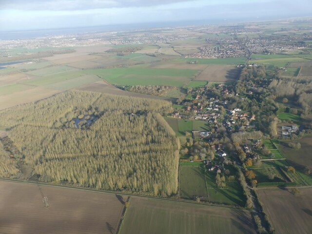
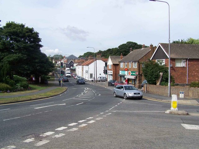
Barnoldby le Beck is a small village located in the East Lindsey district of Lincolnshire, England. Situated approximately 5 miles southwest of Grimsby, it is nestled between the towns of Waltham and Swallow.

The village is known for its picturesque countryside and tranquil atmosphere, attracting visitors seeking a peaceful retreat from the hustle and bustle of city life. With a population of around 500 residents, Barnoldby le Beck has a close-knit community that values its rural heritage.

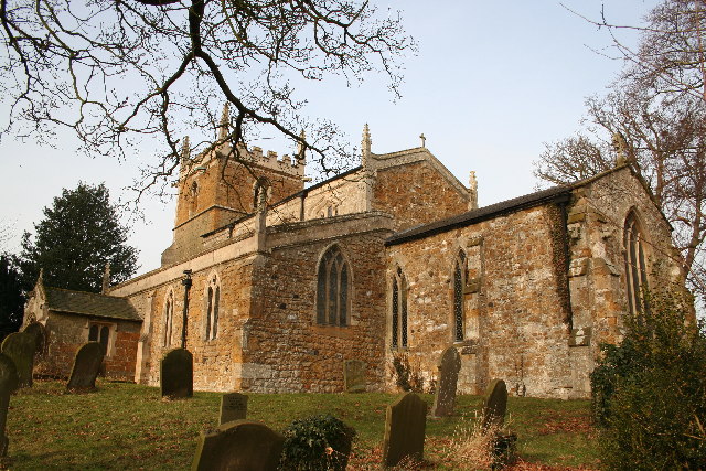
The village boasts a number of charming cottages and traditional farmhouses, some of which date back several centuries. The local architecture is representative of the region's rich history, with many buildings featuring unique brickwork and thatched roofs. The village also has a small, historic church named St. Helen's, which serves as a focal point for community events and religious services.

Surrounded by rolling hills and farmland, Barnoldby le Beck offers ample opportunities for outdoor activities such as hiking, cycling, and birdwatching. The nearby Lincolnshire Wolds, an Area of Outstanding Natural Beauty, provides breathtaking views and scenic trails for nature enthusiasts.

Despite its peaceful setting, the village benefits from good transport links, with easy access to the A18 road and the nearby Humberside Airport. This allows residents to enjoy the tranquility of rural life while remaining well-connected to larger towns and cities for work and leisure opportunities.

If you have any feedback on the listing, please let us know in the comments section below.

Barnoldby le Beck Images

Images are sourced within 2km of 53.510817/-0.1392737 or Grid Reference TA2303. Thanks to Geograph Open Source API. All images are credited.

Calcrete in the dry bed of Wellbeck Spring (1) The spring is dry again, and it's only July - see <a href="https://www.geograph.org.uk/photo/4207466">TA2204 : The dry bed of Welbeck Spring</a> and <a href="https://www.geograph.org.uk/photo/6825505">TA2204 : Wellbeck Spring and watercress bed (1)</a>.
Calcrete in the dry bed of Wellbeck Spring (1)
The spring is dry again, and it's only July - see TA2204 : The dry bed of Welbeck Spring and TA2204 : Wellbeck Spring and watercress bed (1).
Wellbeck spring is dry again And it's only July! See <a href="https://www.geograph.org.uk/photo/4207466">TA2204 : The dry bed of Welbeck Spring</a> and <a href="https://www.geograph.org.uk/photo/6825505">TA2204 : Wellbeck Spring and watercress bed (1)</a>.
Wellbeck spring is dry again
Water forget-me-nots in the dry bed of Wellbeck spring The spring is dry again, and it's only July - see <a href="https://www.geograph.org.uk/photo/4207466">TA2204 : The dry bed of Welbeck Spring</a> and <a href="https://www.geograph.org.uk/photo/6825505">TA2204 : Wellbeck Spring and watercress bed (1)</a>.
Water forget-me-nots in the dry bed of Wellbeck spring
The spring is dry again, and it's only July - see TA2204 : The dry bed of Welbeck Spring and TA2204 : Wellbeck Spring and watercress bed (1).
Wellbeck Spring is dry already And it's only July! See <a href="https://www.geograph.org.uk/photo/4207466">TA2204 : The dry bed of Welbeck Spring</a> and <a href="https://www.geograph.org.uk/photo/6825505">TA2204 : Wellbeck Spring and watercress bed (1)</a>.
Wellbeck Spring is dry already
Calcrete in the dry bed of Wellbeck Spring (2) The spring is dry again, and it's only July - see <a href="https://www.geograph.org.uk/photo/4207466">TA2204 : The dry bed of Welbeck Spring</a> and <a href="https://www.geograph.org.uk/photo/6825505">TA2204 : Wellbeck Spring and watercress bed (1)</a>.
Calcrete in the dry bed of Wellbeck Spring (2)
The spring is dry again, and it's only July - see TA2204 : The dry bed of Welbeck Spring and TA2204 : Wellbeck Spring and watercress bed (1).
Barnoldby le Beck roundabout, A18: aerial 2022 (1)
Barnoldby le Beck roundabout, A18: aerial 2022 (2)
Waithe Beck south of Barnoldby le Beck: aerial 2022
Welbeck Spring: aerial 2022 See <a href="https://www.geograph.org.uk/photo/6825505">TA2204 : Wellbeck Spring and watercress bed (1)</a> and <a href="https://www.geograph.org.uk/photo/7503990">TA2204 : Welbeck spring flows again - June 2023 (2)</a> - the spring runs, and <a href="https://www.geograph.org.uk/photo/6925158">TA2204 : Wellbeck spring is dry again</a> - the spring is dry.
The jury is out as to whether it is running in this shot.

The water runs deep and fast, but not all of the time. It was said by a certain George Oliver in the 19th century: "[Welbeck Spring] which was 'uniformly dry during the winter season, but in the month of February or March, a loud rumbling noise is heard in the ground for several days, and at length the water bursts forth in a hundred places as to fill in a few hours the whole area of the well or enclosure of earth where it is situated...". See <span class="nowrap"><a title="https://en.wikipedia.org/wiki/Welbeck_Hill" rel="nofollow ugc noopener" href="https://en.wikipedia.org/wiki/Welbeck_Hill">Link</a><img style="margin-left:2px;" alt="External link" title="External link - shift click to open in new window" src="https://s1.geograph.org.uk/img/external.png" width="10" height="10"/></span>
Welbeck Spring: aerial 2022
See TA2204 : Wellbeck Spring and watercress bed (1) and TA2204 : Welbeck spring flows again - June 2023 (2) - the spring runs, and TA2204 : Wellbeck spring is dry again - the spring is dry. The jury is out as to whether it is running in this shot. The water runs deep and fast, but not all of the time. It was said by a certain George Oliver in the 19th century: "[Welbeck Spring] which was 'uniformly dry during the winter season, but in the month of February or March, a loud rumbling noise is heard in the ground for several days, and at length the water bursts forth in a hundred places as to fill in a few hours the whole area of the well or enclosure of earth where it is situated...". See LinkExternal link
Ploughed field west of Barnoldby le Beck: aerial 2023
Welbeck spring flows again - June 2023 (1) Last seen running in May 2021, when the pool by the spring was full of watercress and lush growth.

What looks like water weed waving in the water is in fact grass, which had been growing in peace in the dry stream bed until recently.

For this and full details see <a href="https://www.geograph.org.uk/photo/6825505">TA2204 : Wellbeck Spring and watercress bed (1)</a>.
Welbeck spring flows again - June 2023 (1)
Last seen running in May 2021, when the pool by the spring was full of watercress and lush growth. What looks like water weed waving in the water is in fact grass, which had been growing in peace in the dry stream bed until recently. For this and full details see TA2204 : Wellbeck Spring and watercress bed (1).
Welbeck spring flows again - June 2023 (2) Last seen running in May 2021, when the pool by the spring was full of watercress and lush growth.

For this and full details see <a href="https://www.geograph.org.uk/photo/6825505">TA2204 : Wellbeck Spring and watercress bed (1)</a>.
Welbeck spring flows again - June 2023 (2)
Last seen running in May 2021, when the pool by the spring was full of watercress and lush growth. For this and full details see TA2204 : Wellbeck Spring and watercress bed (1).
Field by Waithe Beck, between Barnoldby le Beck and Hatcliffe Top: aerial 2023
Waithe Beck and Wanderlust Way towards Hatcliffe: aerial 2023
Woodland, Barnoldby le Beck: aerial 2023
St.Helen's church, Barnoldby-le-Beck, Lincs. Much restored with Norman origins and some medieval glass.
St.Helen's church, Barnoldby-le-Beck, Lincs.
Much restored with Norman origins and some medieval glass.
Wanderlust Way The signpost points northwards along the "Wanderlust Way". The obelisk is a monument to William Shaw of Brocklesby .. the plaque reads 'This monument was erected by his many friends as a token of their regard and to mark the spot where William Smith, huntsman to the Earl of Yarborough fell on 11th April 1845. His gallant horsemanship and management of hounds in the kennel and in the field were unsurpassed. His horse falling over a small leap whilst Smith was cheering on his favourite hounds, he was thrown on his head and from the injuries he then received, he died on 16th April 1845 at the house of his friend Richard Nainby of this village esquire, by whom the site for this memorial was given on the 6th day of April 1861'
Wanderlust Way
The signpost points northwards along the "Wanderlust Way". The obelisk is a monument to William Shaw of Brocklesby .. the plaque reads 'This monument was erected by his many friends as a token of their regard and to mark the spot where William Smith, huntsman to the Earl of Yarborough fell on 11th April 1845. His gallant horsemanship and management of hounds in the kennel and in the field were unsurpassed. His horse falling over a small leap whilst Smith was cheering on his favourite hounds, he was thrown on his head and from the injuries he then received, he died on 16th April 1845 at the house of his friend Richard Nainby of this village esquire, by whom the site for this memorial was given on the 6th day of April 1861'
Grange Farm, Barnoldby-Le-Beck
Show me another place!

Barnoldby le Beck is located at Grid Ref: TA2303 (Lat: 53.510817, Lng: -0.1392737)

Division: Parts of Lindsey

Unitary Authority: North East Lincolnshire

Police Authority: Humberside

What 3 Words

///fresh.unicorns.refrained. Near Waltham, Lincolnshire

Related Wikis

Nearby Amenities

Located within 500m of 53.510817,-0.1392737
Barnoldby le Beck
Is In: Lincolnshire, England, UK
Is In District: North East Lincolnshire
Place: village
Source: npe
Lat/Long: 53.5114617/-0.1374487
Bus Stop
Church Lane
Naptan AtcoCode: 2280000191
Naptan Bearing: NE
Naptan CommonName: Church Lane
Naptan Crossing: Church Lane
Naptan Indicator: adj
Naptan Landmark: The Ship Inn
Naptan NaptanCode: gripdaw
Naptan Notes: none
Naptan Street: Waltham Road
Naptan Verified: no
Source: naptan_import
Lat/Long: 53.5112076/-0.1377944
Barrier: kissing_gate
Kissing Gate: triangular_profile
Source: survey
Lat/Long: 53.5106801/-0.1382479
Barrier: kissing_gate
Kissing Gate: triangular_profile
Source: survey
Lat/Long: 53.5099465/-0.1375452
Barrier: stile
Lat/Long: 53.5083253/-0.1434287
Barrier: stile
Lat/Long: 53.5093229/-0.1406772
Pub
Ship Inn
Addr City: Grimsby
Addr Postcode: DN37 0BG
Addr Street: Main Road
Addr Suburb: Barnoldby le Beck
Check Date Opening Hours: 2022-04-02
Contact Facebook: https://www.facebook.com/theshipinnbarnoldby
Contact Instagram: https://www.instagram.com/theshipinnbarnoldby
Email: contact@theshipinnbarnoldby.com
Opening Hours: Tu-Th 12:00-15:00; Fr-Sa 12:00-23:00; Su 12:00-20:00; Mo closed
Outdoor Seating: yes
Phone: +44 1472 822 308
Source: survey
Takeaway: yes
Website: https://www.theshipinnbarnoldby.com/
Lat/Long: 53.5112338/-0.1371816
Waste Basket
Waste: trash
Lat/Long: 53.5110281/-0.1384529
Bench
Lat/Long: 53.5110823/-0.1384798
Bench
Lat/Long: 53.5110492/-0.1386152
Waste Basket
Waste: trash
Lat/Long: 53.5122092/-0.1378924
Bench
Backrest: yes
Lat/Long: 53.5121318/-0.1378441
Post Box
Check Date: 2024-03-07
Collection Plate: CP1D
Collection Times: Mo-Fr 09:00; Sa 07:00
Image: https://i.postimg.cc/QCkRxLJJ/DN37-30D.jpg
Location: Chapel Lane
Operator: Royal Mail
Operator Wikidata: Q638098
Post Box Mounting: brick_pillar
Post Box Type: wall
Ref: DN37 30D
Royal Cypher: GR
Royal Cypher Wikidata: Q33102273
Source: survey
Lat/Long: 53.5112978/-0.1378017
The data included in this document is from www.openstreetmap.org. The data is made available under ODbL.

Have you been to Barnoldby le Beck?

Leave your review of Barnoldby le Beck below (or comments, questions and feedback).