Gleann a' Phuill

Valley in Inverness-shire

Scotland

Gleann a' Phuill

Deer fence on Ben Corkeval An enormous area of land is enclosed by this deer fence, though I am not sure if it is meant to be keeping deer in or out - I saw deer on both sides of the fence... The Outer Hebridean island of North Uist lines up along the horizon.
Deer fence on Ben Corkeval Credit: Richard Dorrell

Gleann a' Phuill, located in Inverness-shire, Scotland, is a picturesque valley renowned for its natural beauty and captivating landscapes. Nestled amidst the Highlands, it is a haven for nature enthusiasts and offers a serene and tranquil escape from the hustle and bustle of urban life.

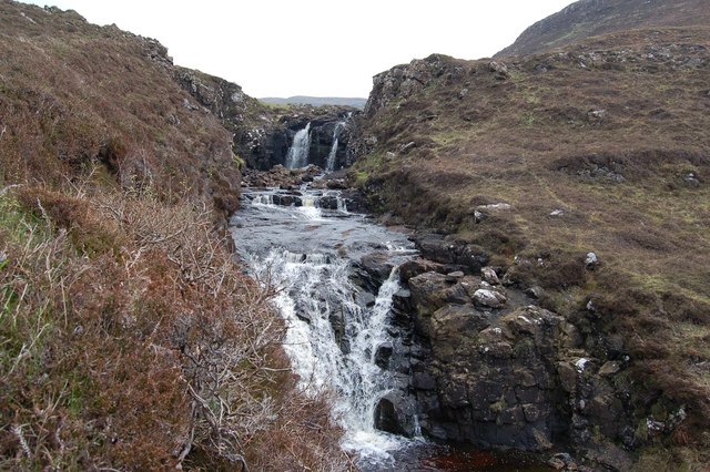
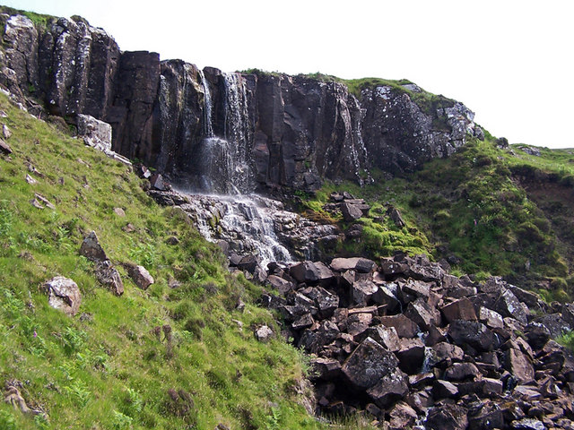
The valley is characterized by its rolling hills, lush greenery, and the meandering River Phuill, which adds to its charm. The river flows gracefully through the valley, providing a soothing backdrop to the surrounding scenery. Visitors can enjoy leisurely walks along its banks, taking in the sights and sounds of the abundant wildlife that call the valley home.

Gleann a' Phuill is also known for its diverse flora and fauna. The valley is blanketed with a vibrant carpet of wildflowers during the spring and summer months, creating a colorful and enchanting landscape. It is not uncommon to spot deer, birds of prey, and other wildlife while exploring the area.

For those seeking outdoor activities, the valley offers numerous opportunities for hiking and cycling. There are several well-marked trails that wind their way through the valley, offering stunning panoramic views of the surrounding mountains and countryside. The valley is also a popular spot for fishing, with the River Phuill providing ample opportunities to catch trout and salmon.

Overall, Gleann a' Phuill is a hidden gem in Inverness-shire, offering a peaceful and idyllic retreat for nature lovers and outdoor enthusiasts. Its untouched beauty and serene atmosphere make it a must-visit destination for anyone seeking respite in the heart of the Scottish Highlands.

If you have any feedback on the listing, please let us know in the comments section below.

Gleann a' Phuill Images

Images are sourced within 2km of 57.395711/-6.6858694 or Grid Reference NG1843. Thanks to Geograph Open Source API. All images are credited.

Deer fence on Ben Corkeval An enormous area of land is enclosed by this deer fence, though I am not sure if it is meant to be keeping deer in or out - I saw deer on both sides of the fence... The Outer Hebridean island of North Uist lines up along the horizon.
Deer fence on Ben Corkeval
An enormous area of land is enclosed by this deer fence, though I am not sure if it is meant to be keeping deer in or out - I saw deer on both sides of the fence... The Outer Hebridean island of North Uist lines up along the horizon.
Drought on the hills It's not often we see peat bogs dry and cracked on the Isle of Skye. This is close to the summit of Ben Corkeval.
Drought on the hills
It's not often we see peat bogs dry and cracked on the Isle of Skye. This is close to the summit of Ben Corkeval.
Deer fence on the summit  This is close to the summit of Ben Corkeval. The flat topped hills in the background are Macleod's Tables. The deer fence continues for miles, enclosing a very large area of the north east facing slope of the hill. Parts of the enclosed hillside have been planted with broadleaf trees.
Deer fence on the summit
This is close to the summit of Ben Corkeval. The flat topped hills in the background are Macleod's Tables. The deer fence continues for miles, enclosing a very large area of the north east facing slope of the hill. Parts of the enclosed hillside have been planted with broadleaf trees.
Descending Ben Corkeval This is the east facing slope of the hill. In spite of a lack of rain recently, the grasses, mosses and heather have grown thickly here, and make for difficult walking. Parts of this hillside have been planted with trees, and are marked on some OS maps as woodland. The trees are only a couple of feet tall at the moment. The hill in cloud shadow in the background is Healabhal Mhòr, otherwise known as MacLeod's Table North, with summit in <a href="https://www.geograph.org.uk/gridref/NG2244">NG2244</a>.
Descending Ben Corkeval
This is the east facing slope of the hill. In spite of a lack of rain recently, the grasses, mosses and heather have grown thickly here, and make for difficult walking. Parts of this hillside have been planted with trees, and are marked on some OS maps as woodland. The trees are only a couple of feet tall at the moment. The hill in cloud shadow in the background is Healabhal Mhòr, otherwise known as MacLeod's Table North, with summit in NG2244.
North east slope of Ben Corkeval A very large area of this hillside has been planted with young trees, currently barely taller than the grass and heather and not visible in this image. However in time, they will transform the appearance of the hillside.
North east slope of Ben Corkeval
A very large area of this hillside has been planted with young trees, currently barely taller than the grass and heather and not visible in this image. However in time, they will transform the appearance of the hillside.
Woodland? Some OS maps mark parts of this hillside on the eastern slope of Ben Corkeval as woodland. Sure enough, trees have been planted here, and the whole hillside is surrounded by a deer fence to stop browsing deer from nibbling the trees. But just yet, the trees are barely taller than the heather, grasses and mosses among which they are growing. There is a young birch in this shot, slightly left and below the centre of the image.
Woodland?
Some OS maps mark parts of this hillside on the eastern slope of Ben Corkeval as woodland. Sure enough, trees have been planted here, and the whole hillside is surrounded by a deer fence to stop browsing deer from nibbling the trees. But just yet, the trees are barely taller than the heather, grasses and mosses among which they are growing. There is a young birch in this shot, slightly left and below the centre of the image.
It's that fence again A deer fence surrounds a very large area of hillside on the eastern slope of Ben Corkeval. Parts of the hillside have been planted with trees, which will transform the appearance of the hill once they are grown, though they are currently no more than a couple of feet tall. The fence has sturdy strainer posts at intervals, so it is not too difficult to climb over.
It's that fence again
A deer fence surrounds a very large area of hillside on the eastern slope of Ben Corkeval. Parts of the hillside have been planted with trees, which will transform the appearance of the hill once they are grown, though they are currently no more than a couple of feet tall. The fence has sturdy strainer posts at intervals, so it is not too difficult to climb over.
Just moorland... ...and very little else. On the right is the lower end of a gorge through which the Allt na Banachaig flows.
Just moorland...
...and very little else. On the right is the lower end of a gorge through which the Allt na Banachaig flows.
Lazybeds at Ramasaig The stripes in the grassland are evidence of former cultivation, when the hillside was farmed in strips known as lazybeds. The crop, often potatoes, was planted on the ridge, with the furrow providing drainage.
Lazybeds at Ramasaig
The stripes in the grassland are evidence of former cultivation, when the hillside was farmed in strips known as lazybeds. The crop, often potatoes, was planted on the ridge, with the furrow providing drainage.
Ford on the Lorgill track Where the old cart track crosses the Lon Ban.
Ford on the Lorgill track
Where the old cart track crosses the Lon Ban.
Lorgill Village Sheep making the most of the land that was cleared of humans to make way for them.

The inhabitants of Lorgill were forcibly shipped from here to Nova Scotia in 1830.
Lorgill Village
Sheep making the most of the land that was cleared of humans to make way for them. The inhabitants of Lorgill were forcibly shipped from here to Nova Scotia in 1830.
Waterfall on the Lorgill River The river falls here as it enters the Lorgill valley.
Waterfall on the Lorgill River
The river falls here as it enters the Lorgill valley.
Creag na h-Aire Crags to the east of the Lorgill valley.
Creag na h-Aire
Crags to the east of the Lorgill valley.
From Lon Ban towards Neist Point Lighthouse
Lorgill ruins The ruins are all that are left to show where the once thriving community of a dozen or more families once lived.In 1830, at very short notice,they were ordered to leave to make way for tenant farmers and their sheep.
Lorgill ruins
The ruins are all that are left to show where the once thriving community of a dozen or more families once lived.In 1830, at very short notice,they were ordered to leave to make way for tenant farmers and their sheep.
Waterfall down into Lorgill
Western slopes of Ben Corkeval Looking towards Ramasaig.
Western slopes of Ben Corkeval
Looking towards Ramasaig.
Deer fence on the north ridge of Ben Corkeval This gentle slope on the north of the hill is boggy in places, but gives the easiest way on and off the hill.
Deer fence on the north ridge of Ben Corkeval
This gentle slope on the north of the hill is boggy in places, but gives the easiest way on and off the hill.
Show me another place!

Gleann a' Phuill is located at Grid Ref: NG1843 (Lat: 57.395711, Lng: -6.6858694)

Unitary Authority: Highland

Police Authority: Highlands and Islands

What 3 Words

///protests.barstool.racks. Near Glendale, Highland

Related Wikis

Ramasaig

Ramasaig is a small township on the western shore of the Duirinish peninsula, on Dunvegan, Isle of Skye and is in the Scottish Highlands and is in the...

Eas Mòr, Durinish

Eas Mòr is a waterfall on the Duirinish peninsula of the island of Skye in Scotland. It lies on the Allt Mhicheil, a tributary of the Dibidal River below...

Healabhal Bheag

Healabhal Bheag is a hill located on the Duirinish peninsula of the Isle of Skye in the Inner Hebrides, Scotland. It is also known as MacLeod's Table South...

Borrodale

Borrodale (Scottish Gaelic: Borodail) is small hamlet on the Isle of Skye, in the Inner Hebrides of Scotland. Borrodale is part of Glendale and the Glendale...

Nearby Amenities

Located within 500m of 57.395711,-6.6858694
Gleann a'Phuill
Place: locality
Lat/Long: 57.3974984/-6.6865498
The data included in this document is from www.openstreetmap.org. The data is made available under ODbL.

Have you been to Gleann a' Phuill?

Leave your review of Gleann a' Phuill below (or comments, questions and feedback).