Glac Smearasmal

Valley in Inverness-shire

Scotland

Glac Smearasmal

Trig Point on Cleiseabhal with view to Leosabhal & Tiorga Mor The walk to the summit of Cleiseabhal is surprisingly easy after leaving the B887 at NB065072 and making for the southwest ridge, however the first few hundred feet there is tussicky grass to cross.
Trig Point on Cleiseabhal with view to Leosabhal & Tiorga Mor Credit: Colin Park

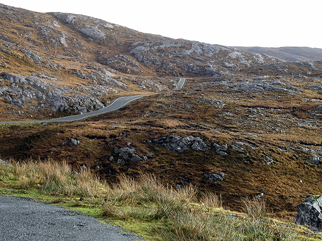
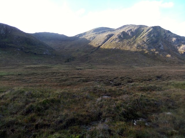
Glac Smearasmal is a picturesque valley located in the Inverness-shire region of Scotland. This valley is known for its stunning natural beauty, with rolling hills, lush green meadows, and sparkling streams weaving their way through the landscape. The valley is surrounded by towering mountains, creating a dramatic backdrop for visitors to admire.

Glac Smearasmal is a popular destination for outdoor enthusiasts, offering a variety of activities such as hiking, mountain biking, and fishing. The valley is also home to an abundance of wildlife, including red deer, golden eagles, and otters, making it a haven for nature lovers.

Visitors to Glac Smearasmal can explore the charming villages that dot the valley, each offering a unique glimpse into the local culture and history. The valley is also home to a number of historic sites, such as ancient ruins and stone circles, giving visitors a chance to step back in time and learn about the area's rich heritage.

Overall, Glac Smearasmal is a tranquil and idyllic destination that offers a perfect escape for those looking to immerse themselves in the beauty of the Scottish countryside.

If you have any feedback on the listing, please let us know in the comments section below.

Glac Smearasmal Images

Images are sourced within 2km of 57.963389/-6.9289243 or Grid Reference NB0807. Thanks to Geograph Open Source API. All images are credited.

Trig Point on Cleiseabhal with view to Leosabhal & Tiorga Mor The walk to the summit of Cleiseabhal is surprisingly easy after leaving the B887 at NB065072 and making for the southwest ridge, however the first few hundred feet there is tussicky grass to cross.
Trig Point on Cleiseabhal with view to Leosabhal & Tiorga Mor
The walk to the summit of Cleiseabhal is surprisingly easy after leaving the B887 at NB065072 and making for the southwest ridge, however the first few hundred feet there is tussicky grass to cross.
Ridge leading northeast from Cleiseabhal This grassy ridge looks easy to walk but part way down, a rock band bisects the ridge which requires a short 'down scramble'.
Ridge leading northeast from Cleiseabhal
This grassy ridge looks easy to walk but part way down, a rock band bisects the ridge which requires a short 'down scramble'.
Rock band between Cleiseabhal & Bidigidh This rock band bisects the ridge and involves a short scramble.
Rock band between Cleiseabhal & Bidigidh
This rock band bisects the ridge and involves a short scramble.
Track leading north through Gleann Mhiabhaig
Eagle observation cabin, Gleann Mhiabhaig & Sron Scourst
A Harris Primary School By the roadside, on a cliff top, on the Isle of Harris you'll find this school and it's hard not to be moved by the pure simplicity of its form and the staggering importance of its being.
A Harris Primary School
By the roadside, on a cliff top, on the Isle of Harris you'll find this school and it's hard not to be moved by the pure simplicity of its form and the staggering importance of its being.
Dusk by Bagh Chliasmol
Bridge over the Abhainn Mhiabhaig The bridge marks the half way point to the eagle observation hut.
Bridge over the Abhainn Mhiabhaig
The bridge marks the half way point to the eagle observation hut.
Where eagles sometimes dare.. The bridge marks the half way point to the eagle observation hut.
Where eagles sometimes dare..
The bridge marks the half way point to the eagle observation hut.
The settlement at Cliasmol
Bàgh Chliasmol
Bàgh Chliasmol
The road near Brandarsaig
Abhainn a' Mhiabhaig Swelled to a torrent.
Abhainn a' Mhiabhaig
Swelled to a torrent.
Coastline near Leabaidh a' Mhèirlich, Harris
Bridge in Gleann Miabhaig
In Gleann Miabhaig
In Gleann Miabhaig
The B887 near Cliasmol, Harris The sign warns of <a href="https://www.geograph.org.uk/photo/3949052">NB0806 : Bun Sgoil Chliasmoil</a> (although it had shut eight years before this photo was taken)
The B887 near Cliasmol, Harris
The sign warns of NB0806 : Bun Sgoil Chliasmoil (although it had shut eight years before this photo was taken)
Hillside below Cleiseabhal
Show me another place!

Glac Smearasmal is located at Grid Ref: NB0807 (Lat: 57.963389, Lng: -6.9289243)

Unitary Authority: Na h-Eileanan an Iar

Police Authority: Highlands and Islands

What 3 Words

///modules.diplomats.bright. Near Tarbert, Na h-Eileanan Siar

Nearby Locations

Glac Smearasmal

Related Wikis

Oireabhal

Oireabhal (662 m) is a mountain in Harris, in the Outer Hebrides of Scotland. The peak is the highest point on a complex ridge that runs from north to...

Soay Sound

Soay Sound (Scottish Gaelic: Caolas Shòdhaigh) is a strait separating the islands of Soay Mòr and Soay Beag from the northern part of Harris. The sound...

Chliostair Hydro-Electric Scheme

Chliostair Hydro-Electric Scheme is a small scheme promoted by the North of Scotland Hydro-Electric Board on Harris, Outer Hebrides. It consists of a single...

Soay Mòr

Soay Mòr (Scottish Gaelic: Sòdhaigh Mòr) is an island in West Loch Tarbert, between the northern and southern parts of Harris. The uninhabited island is...

Have you been to Glac Smearasmal?

Leave your review of Glac Smearasmal below (or comments, questions and feedback).