Cathelle Houses

Hill, Mountain in Angus

Scotland

Cathelle Houses

Remains of fank, Glen Clova The outline of stones indicate the possibility of a fairly large fank being in existence. Nearby there are the ruins of a dwelling. See <a href="https://www.geograph.org.uk/photo/5466583">NO3074 : Ruined dwelling at Bontyre, Glen Clova</a>
Remains of fank, Glen Clova Credit: Douglas Nelson

Cathelle Houses is an awe-inspiring hill/mountain located in the Angus region of Scotland. Rising majestically to a height of approximately 700 meters (2,300 feet), it offers breathtaking views and a unique experience for nature enthusiasts, hikers, and adventure seekers.

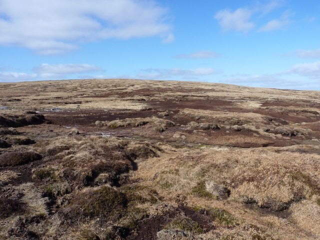
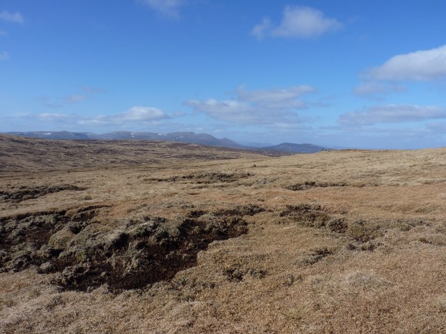
The hill/mountain is known for its rugged terrain, characterized by steep slopes and rocky outcrops. It is a challenging yet rewarding destination for climbers and experienced hikers looking to test their skills and endurance. The summit of Cathelle Houses provides a panoramic view of the surrounding landscape, including rolling hills, picturesque valleys, and distant mountain ranges. On clear days, one can even catch a glimpse of the nearby North Sea shimmering in the distance.

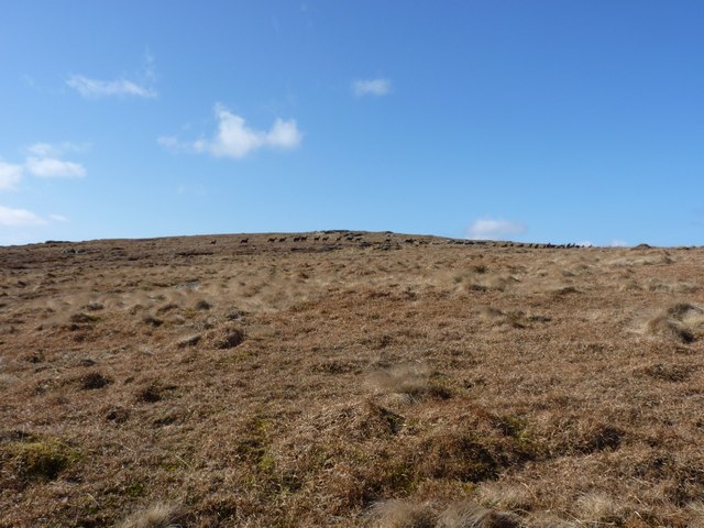
The area around Cathelle Houses is rich in biodiversity, with a variety of plant and animal species thriving in its diverse ecosystems. It is home to several rare and protected species, including indigenous Scottish wildlife such as red deer, golden eagles, and mountain hares.

Visitors to Cathelle Houses can explore a network of well-maintained trails that cater to different levels of difficulty. These trails wind through heather-clad moorland, ancient woodlands, and tranquil glens, offering a chance to immerse oneself in the natural beauty and tranquility of the area.

Overall, Cathelle Houses in Angus is a remarkable hill/mountain that showcases the stunning landscapes and wildlife that Scotland has to offer. Whether one is seeking an adrenaline-fueled adventure or simply a peaceful retreat in nature, Cathelle Houses is a destination that guarantees an unforgettable experience.

If you have any feedback on the listing, please let us know in the comments section below.

Cathelle Houses Images

Images are sourced within 2km of 56.873738/-3.1294289 or Grid Reference NO3176. Thanks to Geograph Open Source API. All images are credited.

Remains of fank, Glen Clova The outline of stones indicate the possibility of a fairly large fank being in existence. Nearby there are the ruins of a dwelling. See <a href="https://www.geograph.org.uk/photo/5466583">NO3074 : Ruined dwelling at Bontyre, Glen Clova</a>
Remains of fank, Glen Clova
The outline of stones indicate the possibility of a fairly large fank being in existence. Nearby there are the ruins of a dwelling. See NO3074 : Ruined dwelling at Bontyre, Glen Clova
Split boulder on Benty Roads Mount Keen on the horizon.
Split boulder on Benty Roads
Mount Keen on the horizon.
Corrie of Bonhard drops sharply below Driesh is the hill across Glen Clova.
Corrie of Bonhard drops sharply below
Driesh is the hill across Glen Clova.
Benty Roads The summit area of Benty Roads
Benty Roads
The summit area of Benty Roads
The Corrie of Clova
The Corrie of Clova
Peat bog below Benty Roads Easy to cross on a dry day like this, but it would prove a bit of a thrash in wetter conditions.
Peat bog below Benty Roads
Easy to cross on a dry day like this, but it would prove a bit of a thrash in wetter conditions.
The summit cairn on Benty Roads A small pile of rocks marking the 841m summit (my GPS gave 2752')
The summit cairn on Benty Roads
A small pile of rocks marking the 841m summit (my GPS gave 2752')
North east of Benty Roads Looking across open moorland towards the Munro of Mount Keen, about 8 miles away. There are at least two major valleys (Glen Lee and Glen Mark) between Benty Roads and that hill.
North east of Benty Roads
Looking across open moorland towards the Munro of Mount Keen, about 8 miles away. There are at least two major valleys (Glen Lee and Glen Mark) between Benty Roads and that hill.
Northwest towards Lochnagar Rough, boggy ground on the western side of Benty Roads.
Northwest towards Lochnagar
Rough, boggy ground on the western side of Benty Roads.
Peat bog below Boustie Ley
Towards Mount Keen from Boustie Ley
The eastern side of Boustie Ley This is open, flattish country with easy walking over short arctic vegetation once you're away from the occasional boggy patch. This shot looks back along the north ridge of Glen Clova towards the Corbett called Ben Tirran or The Goet, about 3 miles to the east.
The eastern side of Boustie Ley
This is open, flattish country with easy walking over short arctic vegetation once you're away from the occasional boggy patch. This shot looks back along the north ridge of Glen Clova towards the Corbett called Ben Tirran or The Goet, about 3 miles to the east.
Summit cairn on Boustie Ley No more than a small pile of rocks on this little-visited summit.
Summit cairn on Boustie Ley
No more than a small pile of rocks on this little-visited summit.
Towards Mount Keen from the summit area of Boustie Ley
Into Glen Clova from Boustie Ley The intriguingly-named Laird's Bedchamber forms the hill on the right, a ridge that reaches down from Boustie Ley, before the land drops away into Glen Clova below.
Into Glen Clova from Boustie Ley
The intriguingly-named Laird's Bedchamber forms the hill on the right, a ridge that reaches down from Boustie Ley, before the land drops away into Glen Clova below.
Ben Reid from Boustie Ley The lump of Ben Reid, which looms above Glen Clova.
Ben Reid from Boustie Ley
The lump of Ben Reid, which looms above Glen Clova.
The upper Burn of Bonhard A small, peaty trickle at this point, but it becomes a larger stream further down the corrie below.
The upper Burn of Bonhard
A small, peaty trickle at this point, but it becomes a larger stream further down the corrie below.
Red Deer below Cathelle Houses One of several large herds that we encountered during the course of 3 days in these hills. No shortage of red grouse and hares, either.
Red Deer below Cathelle Houses
One of several large herds that we encountered during the course of 3 days in these hills. No shortage of red grouse and hares, either.
Show me another place!

Cathelle Houses is located at Grid Ref: NO3176 (Lat: 56.873738, Lng: -3.1294289)

Unitary Authority: Angus

Police Authority: Tayside

Also known as: Lair of Whiteston

What 3 Words

///palettes.fruity.wedding. Near Ballater, Aberdeenshire

Related Wikis

Clova, Angus

Clova is a village in Glen Clova, Angus, Scotland. It lies on the River South Esk, some 12 miles (19 km) north of Kirriemuir. During the 1745 Jacobite...

Driesh

Driesh (Gaelic: Dris) is a mountain located in the Grampians of Scotland. Apart from Mount Keen (939 m/3,080 ft), it is the most easterly of the Munro...

Glen Doll

Glen Doll, also sometimes spelt Glendoll, lies within the Cairngorms National Park, Scotland, at the top of Glen Clova, in an area of steep hills, corries...

Corrie Fee

Corrie Fee is a glacier-carved corrie situated at the head of Glen Clova in the Angus Glens of Scotland. It forms part of Corrie Fee National Nature Reserve...

Nearby Amenities

Located within 500m of 56.873738,-3.1294289
Cathelle Houses
Natural: peak
Lat/Long: 56.8725548/-3.1265649
The data included in this document is from www.openstreetmap.org. The data is made available under ODbL.

Have you been to Cathelle Houses?

Leave your review of Cathelle Houses below (or comments, questions and feedback).