Clipyn Du

Hill, Mountain in Montgomeryshire

Wales

Clipyn Du

A view from the summit of Craig Fach The heather covered face of Tarren Gesail is just visible.
A view from the summit of Craig Fach Credit: John Lucas

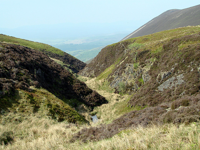
Clipyn Du is a prominent hill located in Montgomeryshire, Wales. Standing at a height of 1,144 feet (349 meters), it is a popular destination for hikers and outdoor enthusiasts looking to explore the rugged Welsh countryside.

The hill is characterized by its steep slopes and rocky terrain, making it a challenging yet rewarding climb for those seeking a physical challenge. From the summit of Clipyn Du, visitors are treated to stunning panoramic views of the surrounding landscape, including the rolling hills and valleys of Montgomeryshire.

The area surrounding Clipyn Du is rich in wildlife, with a variety of plant and animal species calling the hill home. Hikers may spot birds of prey soaring overhead, or catch a glimpse of grazing sheep and other livestock in the fields below.

Overall, Clipyn Du offers visitors a chance to experience the natural beauty and tranquility of the Welsh countryside, while also providing a sense of accomplishment for those who reach its summit. Whether you're a seasoned hiker or just looking for a leisurely stroll, Clipyn Du has something to offer for everyone.

If you have any feedback on the listing, please let us know in the comments section below.

Clipyn Du Images

Images are sourced within 2km of 52.523267/-3.7707643 or Grid Reference SN7993. Thanks to Geograph Open Source API. All images are credited.

A view from the summit of Craig Fach The heather covered face of Tarren Gesail is just visible.
A view from the summit of Craig Fach
The heather covered face of Tarren Gesail is just visible.
Sheep grazing on the slopes of  Tarren Bwlch-gwyn Viewed from to top of Tarren Gesail. Rather them than  me!
Sheep grazing on the slopes of Tarren Bwlch-gwyn
Viewed from to top of Tarren Gesail. Rather them than me!
On Tarren Gesail Looking towards Tarren Bwlch-gwyn. The south face of Tarren Gesail is covered in heather.
On Tarren Gesail
Looking towards Tarren Bwlch-gwyn. The south face of Tarren Gesail is covered in heather.
The precipitous footpath on Tarren Gesail The waterfall of Rhaeadr Wen is seen on the left cascading down from Tarren Bwlch-gwyn.
The precipitous footpath on Tarren Gesail
The waterfall of Rhaeadr Wen is seen on the left cascading down from Tarren Bwlch-gwyn.
On Tarren Allgwm Walking the fence-line down to Llyn Cwm-byr.
On Tarren Allgwm
Walking the fence-line down to Llyn Cwm-byr.
Above Rhaeadr Wen A view of the short stream just before it cascades down Rhaeadr Wen. See <a href="https://www.geograph.org.uk/photo/2397162">SN8193 : The precipitous footpath on Tarren Gesail</a>.
Above Rhaeadr Wen
A view of the short stream just before it cascades down Rhaeadr Wen. See SN8193 : The precipitous footpath on Tarren Gesail.
Llyn Cwm-byr  dam Be very careful when crossing this stile. The cross-plank is loose and likely to leave you straddling the fence!
Llyn Cwm-byr dam
Be very careful when crossing this stile. The cross-plank is loose and likely to leave you straddling the fence!
Track junction at Waun To The track on the left is a right of way leading to Clipyn Du and beyond. That on the right is a farming/forestry track leading to Bugeilyn. Interestingly, the better formed one on the right still hasn't made it onto the 25k map, but has been shown on the 50k sheet since at least the early naughties.
Track junction at Waun To
The track on the left is a right of way leading to Clipyn Du and beyond. That on the right is a farming/forestry track leading to Bugeilyn. Interestingly, the better formed one on the right still hasn't made it onto the 25k map, but has been shown on the 50k sheet since at least the early naughties.
Looking across Tarren Bwlch-gwyn to Clipin Du
Tarren Bwlch-gwyn from the east Looking towards the precipitous northern side of the mountain, as always in shadow, from the edge of the deep cwm on its northern side. A track climbing steadily along the slopes can be seen in the bottom left of the picture. This is unmarked on maps, but is quite a substantial affair, forming a route from the valley entrance to the area around Bugeilyn.
Tarren Bwlch-gwyn from the east
Looking towards the precipitous northern side of the mountain, as always in shadow, from the edge of the deep cwm on its northern side. A track climbing steadily along the slopes can be seen in the bottom left of the picture. This is unmarked on maps, but is quite a substantial affair, forming a route from the valley entrance to the area around Bugeilyn.
Old double-enclosure below Tarren Bwlch-gwyn In 1990 this was clearly visible; the earth embankments were quite substantial, suggesting more than an agricultural purpose. Judging from recent satellite pictures the slopes have now been developed into improved grazing, with little evidence of the structures.
Old double-enclosure below Tarren Bwlch-gwyn
In 1990 this was clearly visible; the earth embankments were quite substantial, suggesting more than an agricultural purpose. Judging from recent satellite pictures the slopes have now been developed into improved grazing, with little evidence of the structures.
The eastern slope of Ffridd Rhosygarreg Sheep pasture, but also used for horse riding judging by the prints in the mud. But not used by many walkers and the track was difficult to access, due to a lot of general mud, and fences across the paths
The eastern slope of Ffridd Rhosygarreg
Sheep pasture, but also used for horse riding judging by the prints in the mud. But not used by many walkers and the track was difficult to access, due to a lot of general mud, and fences across the paths
The track on Ffridd Rhosygarreg Leads through grassy sheep pasture. In the background some more interesting-looking scenery.
The track on Ffridd Rhosygarreg
Leads through grassy sheep pasture. In the background some more interesting-looking scenery.
Sunbeams on Rhos-ffridd-y-garreg viewed from Foel Fadian A lovely interplay between sunlight, clouds and hillside here.
Sunbeams on Rhos-ffridd-y-garreg viewed from Foel Fadian
A lovely interplay between sunlight, clouds and hillside here.
Llyn Cwm-byr dam A steep track descends to the base of the dam here.
Llyn Cwm-byr dam
A steep track descends to the base of the dam here.
Llyn Cwm-byr and its dam
Llyn Cwm-byr dam spillway
Llyn Cwm-byr dam A footbridge is provided to avoid walkers having to ford the outflow from the dam.
Llyn Cwm-byr dam
A footbridge is provided to avoid walkers having to ford the outflow from the dam.
Show me another place!

Clipyn Du is located at Grid Ref: SN7993 (Lat: 52.523267, Lng: -3.7707643)

Unitary Authority: Powys

Police Authority: Dyfed Powys

Also known as: Tarren Bwlch-gwyn

What 3 Words

///scrum.saves.laugh. Near Staylittle, Powys

Related Wikis

Clipyn Du

Clipyn Du is a mountain in northern Powys in Wales. Also known as Tarren Bwlch-Gwyn or Siambwr Trawsfynydd, it is one of the higher summits of the area...

Battle of Mynydd Hyddgen

The Battle of Mynydd Hyddgen took place between the Welsh and English in June 1401. It was part of the Welsh Revolt of 1400-1415 led by Owain Glyndŵr against...

Banc Bugeilyn

Banc Bugeilyn is a hill found in Plynlimon between Aberystwyth and Welshpool in the United Kingdom; grid reference SN826925.The summit is class as a Dewey...

Bryn yr Ŵyn

Bryn yr Ŵyn (Welsh for 'hill of the lambs') is a former Dewey in the foothills of Plynlimon between Aberystwyth and Welshpool in Wales. The summit height...

Nearby Amenities

Located within 500m of 52.523267,-3.7707643
Natural: peak
Source: npe
Lat/Long: 52.5226441/-3.7702526
The data included in this document is from www.openstreetmap.org. The data is made available under ODbL.

Have you been to Clipyn Du?

Leave your review of Clipyn Du below (or comments, questions and feedback).