Bolt's Law

Hill, Mountain in Durham

England

Bolt's Law

Gate in fence on Bolt's Law A public footpath passes through the gate. The trig point might be thought to be at the highest point of the hill but at 540 m it is in fact one metre lower than another location on Bolt's Law, roughly half a kilometre to the south-west, behind the camera position.
Gate in fence on Bolt's Law Credit: Trevor Littlewood

Bolt's Law, also known as Durham Hill or Durham Mountain, is a prominent geographical feature located in the region of Durham in the United Kingdom. The hill/mountain, which is part of the Pennines range, is situated in the northeast of England and lies approximately 15 miles southwest of the city of Durham.

Standing at an elevation of 848 feet (258 meters), Bolt's Law offers stunning views of the surrounding countryside and serves as a popular destination for hikers, nature enthusiasts, and tourists. The hill/mountain is characterized by its steep slopes, rugged terrain, and diverse flora and fauna. The area is home to a variety of plant species, including heather, bilberry, and grasses, which contribute to the vibrant and picturesque landscape.

Bolt's Law is also known for its historical significance. Ruins of an ancient hillfort, believed to date back to the Iron Age, can be found on the summit. These remnants provide archaeologists and historians with valuable insights into the region's past and the lives of its early inhabitants.

Access to Bolt's Law is facilitated by a network of footpaths and trails that cater to different levels of difficulty, allowing visitors to explore and enjoy the natural beauty of the area. The hill/mountain is a popular site for outdoor activities such as hiking, birdwatching, and photography.

In conclusion, Bolt's Law, or Durham Hill/Mountain, is a notable geographical feature in the Durham region of the United Kingdom. With its scenic views, diverse vegetation, and historical significance, it attracts visitors who seek outdoor experiences and a deeper understanding of the area's natural and cultural heritage.

If you have any feedback on the listing, please let us know in the comments section below.
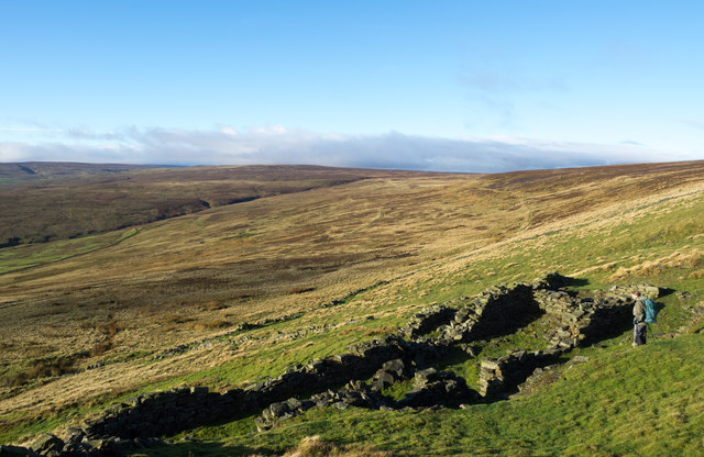
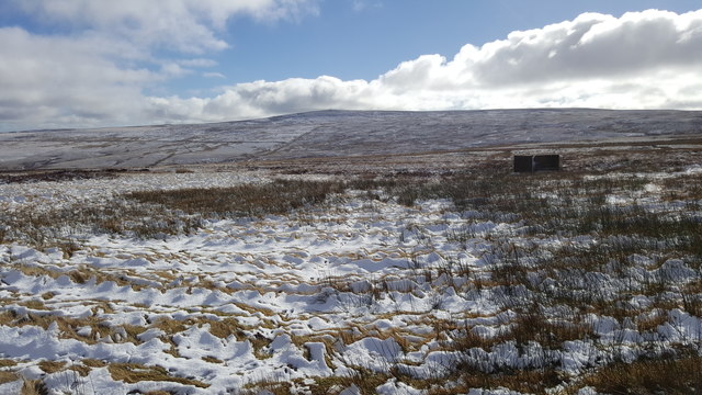
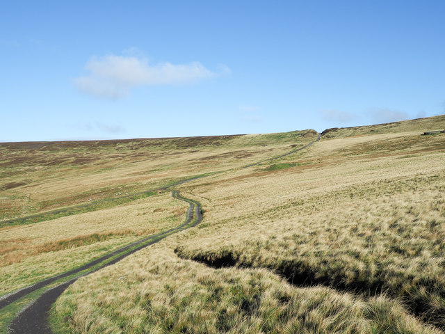
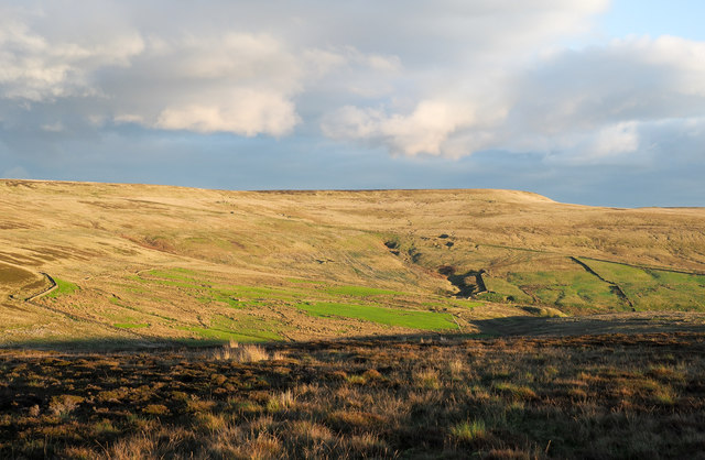
Bolt's Law Images

Images are sourced within 2km of 54.799309/-2.0855193 or Grid Reference NY9444. Thanks to Geograph Open Source API. All images are credited.

Gate in fence on Bolt's Law A public footpath passes through the gate. The trig point might be thought to be at the highest point of the hill but at 540 m it is in fact one metre lower than another location on Bolt's Law, roughly half a kilometre to the south-west, behind the camera position.
Gate in fence on Bolt's Law
A public footpath passes through the gate. The trig point might be thought to be at the highest point of the hill but at 540 m it is in fact one metre lower than another location on Bolt's Law, roughly half a kilometre to the south-west, behind the camera position.
Heather moorland south of Bolt's Law trig point The foreground moorland runs away towards the valley and slopes of the Stanhope Burn. The distant hill is Collier Law.
Heather moorland south of Bolt's Law trig point
The foreground moorland runs away towards the valley and slopes of the Stanhope Burn. The distant hill is Collier Law.
Moorland descending towards Stanhope Burn The area of heather moorland immediately below the camera position is apparently known as Hope Head; a stream groove there and others join to form the Stanhope Burn beyond which lies the sunlit Collier Law.
Moorland descending towards Stanhope Burn
The area of heather moorland immediately below the camera position is apparently known as Hope Head; a stream groove there and others join to form the Stanhope Burn beyond which lies the sunlit Collier Law.
Narrow walled enclosure beside Boltslaw Incline The enclosure surely has no current use. The slope beyond it descends to the fields and village of Rookhope. The flattish area above the break of slope rises gradually to the summit area of Bolt's Law. Boltslaw Incline is just out of view to the right of the image.
Narrow walled enclosure beside Boltslaw Incline
The enclosure surely has no current use. The slope beyond it descends to the fields and village of Rookhope. The flattish area above the break of slope rises gradually to the summit area of Bolt's Law. Boltslaw Incline is just out of view to the right of the image.
Sikehead reservoir and Bolt's Law
Valley of Stogel Cleugh Stogel Cleugh is a feeding stream to Rookhope Burn, itself a tributary valley of the River Wear. The image was recorded from the minor road crossing between Rook Hope in County Durham and Hunstanworth in Northumberland.
Valley of Stogel Cleugh
Stogel Cleugh is a feeding stream to Rookhope Burn, itself a tributary valley of the River Wear. The image was recorded from the minor road crossing between Rook Hope in County Durham and Hunstanworth in Northumberland.
Footpath to Cuthbert's Hill crossing the moor road
Road over Hunstanworth Moor
Grouse butt on Hunstanworth Moor
Grouse butt on Hunstanworth Moor This peak of Bolt's Law is on the horizon
Grouse butt on Hunstanworth Moor
This peak of Bolt's Law is on the horizon
Road near St. Cuthberts Hill on Hunstanworth Moor
Road near Ramshawsike Plantation Looking southward.
Road near Ramshawsike Plantation
Looking southward.
Moorland Road crossing Hunstanworth Moor near White Hill Looking south-westward.
Moorland Road crossing Hunstanworth Moor near White Hill
Looking south-westward.
Moorland Road being crossed by a footpath on Hunstanworth Moor Looking south-westward.
Moorland Road being crossed by a footpath on Hunstanworth Moor
Looking south-westward.
High camp, Stanhope Common Early morning mist fills Weardale.
High camp, Stanhope Common
Early morning mist fills Weardale.
Gate in fence line along path The path in the direction of view is heading towards Bolt's Law.
Gate in fence line along path
The path in the direction of view is heading towards Bolt's Law.
Hill road and Boltslaw Incline The incline descends from the notch on the skyline heading down to Rookhope. The road leaves the incline and makes its way across a ridge, (to the right, out of the image), descending into the valley of the Stanhope Burn.
Hill road and Boltslaw Incline
The incline descends from the notch on the skyline heading down to Rookhope. The road leaves the incline and makes its way across a ridge, (to the right, out of the image), descending into the valley of the Stanhope Burn.
Moorland lit by low-angled sunshine The foreground moorland looks almost to have been burnt - much heather moorland is as part of management for grouse shooting - but this hasn't, the appearance is down to the low angled autumnal sunshine.
The flat-topped moorland hill at the centre of the image is Long Law; the oblique line crossing it is the Boltslaw Incline.
Moorland lit by low-angled sunshine
The foreground moorland looks almost to have been burnt - much heather moorland is as part of management for grouse shooting - but this hasn't, the appearance is down to the low angled autumnal sunshine. The flat-topped moorland hill at the centre of the image is Long Law; the oblique line crossing it is the Boltslaw Incline.
Show me another place!

Bolt's Law is located at Grid Ref: NY9444 (Lat: 54.799309, Lng: -2.0855193)

Unitary Authority: County Durham

Police Authority: Durham

Also known as: Boltslaw West

What 3 Words

///sued.bookshelf.shelved. Near Stanhope, Co. Durham

Nearby Locations

Bolt's Law Boltslaw West

Related Wikis

Ramshaw, Consett

Ramshaw is a small village in County Durham, in England. It is situated to the south of Hunstanworth, a few miles west of Consett. Lead mining was an important...

Lintzgarth

Lintzgarth is a village in the civil parish of Stanhope, in County Durham, England. It is situated to the west of Rookhope. The Lintzgarth smeltmill was...

Townfield

Townfield is a village in County Durham, in England. It is situated just to the south of Hunstanworth and part of that parish, about 10 miles (16 km) west...

Rookhope

Rookhope is a village in the civil parish of Stanhope, in County Durham, England. A former lead and fluorspar mining community, it first existed as a group...

Have you been to Bolt's Law?

Leave your review of Bolt's Law below (or comments, questions and feedback).