Beinn MacDuibh

Hill, Mountain in Aberdeenshire

Scotland

Beinn MacDuibh

Cairn on the north summit of Ben Macdui
Cairn on the north summit of Ben Macdui Credit: Steven Brown

The requested URL returned error: 429 Too Many Requests

If you have any feedback on the listing, please let us know in the comments section below.

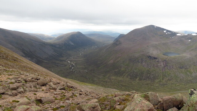
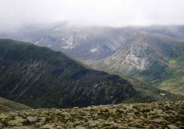
Beinn MacDuibh Images

Images are sourced within 2km of 57.070424/-3.6690851 or Grid Reference NN9898. Thanks to Geograph Open Source API. All images are credited.

Cairn on the north summit of Ben Macdui
Trig point and cairn on Ben Macdui
Path up Ben Macdui
Path up Ben Macdui
Descending east from Ben Macdui A good firm snowfield gave an easy descent towards Loch Etchachan and the western end of Loch Avon. Beinn Mheadhoin is the bulky hill L of centre.
Descending east from Ben Macdui
A good firm snowfield gave an easy descent towards Loch Etchachan and the western end of Loch Avon. Beinn Mheadhoin is the bulky hill L of centre.
Boulderfield at summit of Ben Macdui Rounded, flattened boulders at the summit area of  Ben Macdui viewed from beside the toposcope erected there  in 1925.
Braeriach is the well-snowed mountain seen distantly to the west.
Boulderfield at summit of Ben Macdui
Rounded, flattened boulders at the summit area of Ben Macdui viewed from beside the toposcope erected there in 1925. Braeriach is the well-snowed mountain seen distantly to the west.
The Lairig Ghru, Carn a' Mhaim & Cairn Toul from Braeriach
A photographer on his way to Ben Macdui Yes, it is me, aged 22, on my first significant Scottish hillwalk.

Behind is Angel's Peak, in cloud. Below it, Lochan Uaine is hidden, but the outflow leading to the Lairig Ghru and Glen Dee is clear: see <a href="https://www.geograph.org.uk/photo/7582053">NN9597 : Cairn Toul and Angel's Peak</a> for a view including the lochan.

But the clothing! Warm woollen gloves in July. And a shirt, collar and tie. I think I grew a bit wiser  later.
A photographer on his way to Ben Macdui
Yes, it is me, aged 22, on my first significant Scottish hillwalk. Behind is Angel's Peak, in cloud. Below it, Lochan Uaine is hidden, but the outflow leading to the Lairig Ghru and Glen Dee is clear: see NN9597 : Cairn Toul and Angel's Peak for a view including the lochan. But the clothing! Warm woollen gloves in July. And a shirt, collar and tie. I think I grew a bit wiser later.
The Lairig Ghru and the Devil's Point The Devil's Point is the prominent peak protruding on the right. The more self-effacing Carn a' Mhaim on the left is actually 33 metres higher.
The Lairig Ghru and the Devil's Point
The Devil's Point is the prominent peak protruding on the right. The more self-effacing Carn a' Mhaim on the left is actually 33 metres higher.
A winter day on Ben Macdui A superb day for a winter walk from Cairn Gorm to Ben Macdui (1309m), looking across to the corniced plateau of Braeriach (1296m). The two walkers are consulting the toposcope that lies a short distance W of the summit trig point.
A winter day on Ben Macdui
A superb day for a winter walk from Cairn Gorm to Ben Macdui (1309m), looking across to the corniced plateau of Braeriach (1296m). The two walkers are consulting the toposcope that lies a short distance W of the summit trig point.
Southern slopes of Ben Macdui drop away to Carn a' Mhaim Devil's Point is sunlit in the background.
Southern slopes of Ben Macdui drop away to Carn a' Mhaim
Devil's Point is sunlit in the background.
Stony plateau of Ben Macdui Braeriach in cloud and Cairn Toul on the skyline.
Stony plateau of Ben Macdui
Braeriach in cloud and Cairn Toul on the skyline.
Monadh Ruadh View of some of the highest Cairngorm summits from Mount Keen on a very clear day in early Summer.  Still lots of snow about.  The big three in the picture are Carn an t-Sabhail, Beinn MacDuibh  and Beinn a' Bhuird.  All part of a very elevated granite plateau.
Monadh Ruadh
View of some of the highest Cairngorm summits from Mount Keen on a very clear day in early Summer. Still lots of snow about. The big three in the picture are Carn an t-Sabhail, Beinn MacDuibh and Beinn a' Bhuird. All part of a very elevated granite plateau.
Refreshment on Lairig Ghru walk
Hot work on the Lairig Ghru path
Welcome break by rushing burn Cairn Toul in the background.
Welcome break by rushing burn
Cairn Toul in the background.
Mars, or the moon? The western slope of the north top of Ben Macdui.
Mars, or the moon?
The western slope of the north top of Ben Macdui.
Ben Macdui summit At 1,309m, the second highest summit in the UK.
The view is from close to the cairn and trig, looking past the 1929 toposcope towards Braeriach on the other side of the Lairig Ghru.
Ben Macdui summit
At 1,309m, the second highest summit in the UK. The view is from close to the cairn and trig, looking past the 1929 toposcope towards Braeriach on the other side of the Lairig Ghru.
Sappers Bothy Giving limited shelter on this exposed summit. Standing by the path climbing up from Loch Etchacan.
Sappers Bothy
Giving limited shelter on this exposed summit. Standing by the path climbing up from Loch Etchacan.
Show me another place!

Beinn MacDuibh is located at Grid Ref: NN9898 (Lat: 57.070424, Lng: -3.6690851)

Unitary Authority: Aberdeenshire

Police Authority: North East

Also known as: Ben Macdui, Ben Macdhui

What 3 Words

///interlude.than.relating. Near Inverey, Aberdeenshire

Related Wikis

Ben Macdui

Ben Macdui (Scottish Gaelic: Beinn MacDuibh, meaning "MacDuff's mountain") is the second-highest mountain in Scotland and all of the British Isles, after...

Ly Erg

The Ly Erg is a fairy from Scottish folklore, particularly associated with the area in and around the Glenmore Forest, part of the present-day Cairngorms...

Cairngorms National Park

Cairngorms National Park (Scottish Gaelic: Pàirc Nàiseanta a' Mhonaidh Ruaidh) is a national park in northeast Scotland, established in 2003. It was the...

Lochan Buidhe

Lochan Buidhe is a small freshwater loch located on the Cairngorm Plateau in the eastern Highlands of Scotland. At over 1,120 m (3,670 ft) above sea level...

Nearby Amenities

Located within 500m of 57.070424,-3.6690851
Ben Macdui
Description: Hill of the son of Duff
Ele: 1309
Marilyn: yes
Munro: yes
Munro Number: M002
Name Gd: Beinn Mac Duibh
Natural: peak
Prominence: 950
Wikidata: Q816560
Wikipedia: en:Ben Macdui
Lat/Long: 57.0703889/-3.6691251
Coire Mor
Place: locality
Lat/Long: 57.0729614/-3.6738082
The data included in this document is from www.openstreetmap.org. The data is made available under ODbL.

Have you been to Beinn MacDuibh?

Leave your review of Beinn MacDuibh below (or comments, questions and feedback).