Bell Hill

Hill, Mountain in Essex Basildon

England

Bell Hill

Works on Radford Way, Billericay
Works on Radford Way, Billericay Credit: JThomas

Bell Hill is a small hill located in the county of Essex, in southeastern England. Situated near the town of Ongar, it is part of the wider landscape known as the Essex Hills. Despite its name, Bell Hill is not a mountain but rather a gentle incline that offers panoramic views of the surrounding countryside.

With an elevation of around 82 meters (269 feet) above sea level, Bell Hill is a popular destination for hikers, nature enthusiasts, and locals looking for a peaceful retreat. The hill is known for its well-maintained footpaths and trails, making it easily accessible for visitors of all ages and abilities.

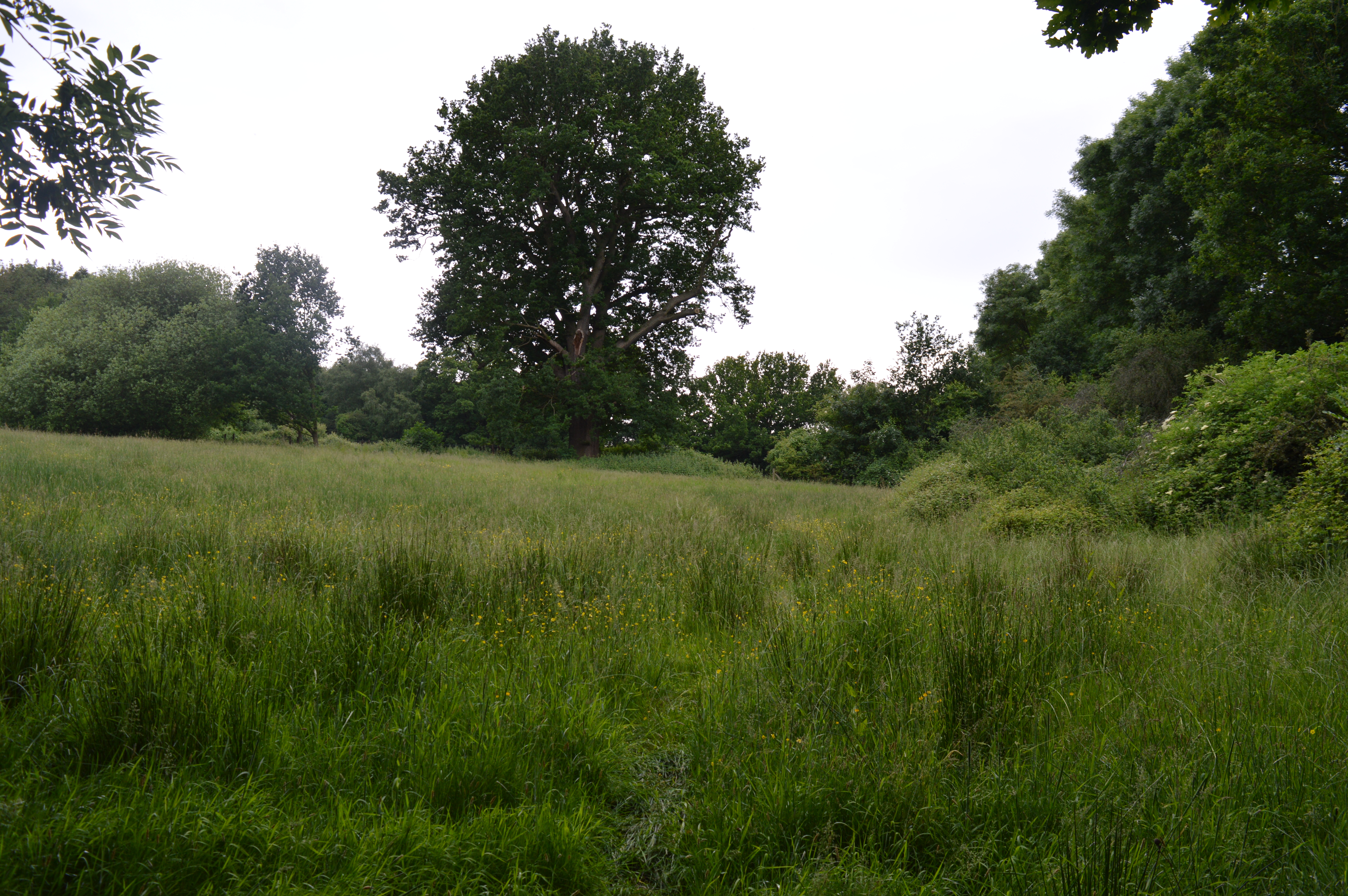
The landscape surrounding Bell Hill is characterized by rolling hills, open fields, and patches of woodland. The area is rich in biodiversity, with various species of flora and fauna calling it home. Visitors to Bell Hill may encounter wildflowers, such as bluebells and primroses, as well as birds, butterflies, and small mammals.

At the summit of Bell Hill, there is a small clearing with a stone bench, providing a perfect spot for visitors to sit and take in the picturesque views. On a clear day, one can see for miles, with the nearby villages, farmland, and even the distant London skyline visible.

Overall, Bell Hill offers a tranquil and scenic escape from the bustling towns and cities of Essex. Its gentle slopes, diverse wildlife, and breathtaking vistas make it a beloved destination for locals and visitors alike.

If you have any feedback on the listing, please let us know in the comments section below.

Bell Hill Images

Images are sourced within 2km of 51.619527/0.4252544 or Grid Reference TQ6793. Thanks to Geograph Open Source API. All images are credited.

Works on Radford Way, Billericay
Houses on London Road
London Road (A129) Towards Billericay.
London Road (A129)
Towards Billericay.
Elizabeth II postbox on London Road Postbox No. CM12 51.
Elizabeth II postbox on London Road
Postbox No. CM12 51.
Roundabout on the A129, Billericay
Businesses on High Street, Billericay
High Street (B1007), Billericay
Pasha Lounge & Shisha, High Street, Billericay
Double aperture Elizabeth II postbox on High Street, Billericay Postbox No. CM12 2 and Postbox No. CM12 222.
See <a href="https://www.geograph.org.uk/photo/7275520">TQ6794 : Royal Mail delivery Office on High Street, Billericay</a> for context.
Double aperture Elizabeth II postbox on High Street, Billericay
Postbox No. CM12 2 and Postbox No. CM12 222. See TQ6794 : Royal Mail delivery Office on High Street, Billericay for context.
Royal Mail delivery Office on High Street, Billericay Showing position of Postbox No. CM12 2 and Postbox No. CM12 222.
See <a href="https://www.geograph.org.uk/photo/7275519">TQ6794 : Double aperture Elizabeth II postbox on High Street, Billericay</a> for postbox.
Royal Mail delivery Office on High Street, Billericay
Showing position of Postbox No. CM12 2 and Postbox No. CM12 222. See TQ6794 : Double aperture Elizabeth II postbox on High Street, Billericay for postbox.
Police Station on High Street, Billericay
Billericay Fire Station On Laindon Road.
Billericay Fire Station
On Laindon Road.
2nd Billericay Scout Group Hall On Laindon Road.
2nd Billericay Scout Group Hall
On Laindon Road.
Reids Bar & Restaurant, Billericay On Laindon Road.
Reids Bar & Restaurant, Billericay
On Laindon Road.
Laindon Road (A176)
Laindon Road (A176)
Businesses on Radford Way, Billericay
Cromwell Avenue, Billericay
Billericay Station, looking east on the London-bound platform
Show me another place!

Bell Hill is located at Grid Ref: TQ6793 (Lat: 51.619527, Lng: 0.4252544)

Administrative County: Essex

District: Basildon

Police Authority: Essex

What 3 Words

///gone.jelly.quest. Near Billericay, Essex

Nearby Locations

Bell Hill

Related Wikis

Mill Meadows, Billericay

Mill Meadows, Billericay is a 6.7-hectare (17-acre) biological Site of Special Scientific Interest (SSSI) in Billericay in Essex, England. It is part of...

The Billericay School

The Billericay School is an academy secondary school and sixth form college located in Billericay, England. The school is led by headmaster Patrick Berry...

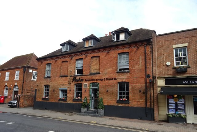
Old Town Hall, Billericay

The Old Town Hall is a municipal building in the High Street, Billericay, Essex, England. The structure, which currently operates as a restaurant, was...

Cater Museum

The Cater Museum is a small local museum in Billericay, Essex county, England. The museum was established by Alice May Cater, in honour of her late husband...

Nearby Amenities

Located within 500m of 51.619527,0.4252544
Bus Stop
Gatwick View
Naptan AtcoCode: 150007002023
Naptan Bearing: NW
Naptan BusStopType: CUS
Naptan CommonName: Gatwick View
Naptan Crossing: Maple Mead
Naptan Indicator: Adj
Naptan Landmark: Gatwick View
Naptan NaptanCode: esxagwmp
Naptan PlusbusZoneRef: BILERCY
Naptan Street: Southend Road
Naptan Verified: no
Public Transport: platform
Source: naptan_import
Lat/Long: 51.6170926/0.4251015
Bus Stop
Weir Wynd
Naptan AtcoCode: 150007004001
Naptan Bearing: SE
Naptan CommonName: Weir Wynd
Naptan Crossing: Weir Wynd
Naptan Indicator: Opp
Naptan Landmark: Weir Wynd
Naptan NaptanCode: esxajamd
Naptan PlusbusZoneRef: BILERCY
Naptan Street: Southend Road
Naptan Verified: no
Public Transport: platform
Shelter: yes
Source: naptan_import
Lat/Long: 51.6208674/0.4191192
Bus Stop
Weir Wynd
Naptan AtcoCode: 150007004002
Naptan Bearing: NW
Naptan CommonName: Weir Wynd
Naptan Crossing: Weir Wynd
Naptan Indicator: Adj
Naptan Landmark: Weir Wynd
Naptan NaptanCode: esxajamg
Naptan PlusbusZoneRef: BILERCY
Naptan Street: Southend Road
Naptan Verified: no
Public Transport: platform
Source: naptan_import
Lat/Long: 51.6209255/0.41892
Bus Stop
School
Naptan AtcoCode: 1500IM967
Naptan Bearing: N
Naptan CommonName: School
Naptan Crossing: Southend Road
Naptan Indicator: o/s
Naptan Landmark: School
Naptan NaptanCode: esxadgtw
Naptan PlusbusZoneRef: BILERCY
Naptan Street: Noak Hill Road
Naptan Verified: no
Public Transport: platform
Source: naptan_import
Lat/Long: 51.6188806/0.4199889
Bus Stop
Gatwick View
Bench: no
Bin: no
Lit: no
Naptan AtcoCode: 1500STHGRN1
Naptan Bearing: SE
Naptan CommonName: Gatwick View
Naptan Crossing: Maple Mead
Naptan Indicator: Opp
Naptan Landmark: Gatwick View
Naptan NaptanCode: esxagwmj
Naptan PlusbusZoneRef: BILERCY
Naptan Street: Southend Road
Naptan Verified: no
Public Transport: platform
Shelter: no
Source: naptan_import
Tactile Paving: no
Lat/Long: 51.6166714/0.4263359
Speed Camera
Lat/Long: 51.6155112/0.4279701
Place Of Worship
Billericay Quaker Meeting House
Religion: christian
Lat/Long: 51.6197905/0.4192831
Give Way
Lat/Long: 51.6162078/0.424318
Give Way
Lat/Long: 51.6161739/0.4244418
Telephone
Booth: KX100
Covered: booth
Lat/Long: 51.6161066/0.4242551
Post Box
Post Box Type: pillar
Ref: CM11 121D
Royal Cypher: GVIR
Royal Cypher Wikidata: Q33102169
Lat/Long: 51.616713/0.4232435
Crossing
Lat/Long: 51.6195778/0.4199524
Generator Method: photovoltaic
Generator Output Electricity: yes
Generator Source: solar
Generator Type: solar_photovoltaic_panel
Location: roof
Power: generator
Lat/Long: 51.6231513/0.42669
Barrier: kissing_gate
Foot: yes
Lat/Long: 51.6223958/0.4271445
Barrier: kissing_gate
Lat/Long: 51.6231533/0.4247979
Barrier: kissing_gate
Lat/Long: 51.620748/0.4192995
Barrier: kissing_gate
Lat/Long: 51.6180041/0.4292244
The data included in this document is from www.openstreetmap.org. The data is made available under ODbL.

Have you been to Bell Hill?

Leave your review of Bell Hill below (or comments, questions and feedback).