Bunkers Hill

Hill, Mountain in Huntingdonshire Huntingdonshire

England

Bunkers Hill

West Lodge farm, Spaldwick West Lodge seen from Cockway Lane.
West Lodge farm, Spaldwick Credit: Michael Trolove

The requested URL returned error: 429 Too Many Requests

If you have any feedback on the listing, please let us know in the comments section below.

Bunkers Hill Images

Images are sourced within 2km of 52.332595/-0.37921192 or Grid Reference TL1071. Thanks to Geograph Open Source API. All images are credited.

West Lodge farm, Spaldwick West Lodge seen from Cockway Lane.
West Lodge farm, Spaldwick
West Lodge seen from Cockway Lane.
Catworth Farm An old dwelling and farm buildings undergoing renovation. Viewed from Cockway Lane
Catworth Farm
An old dwelling and farm buildings undergoing renovation. Viewed from Cockway Lane
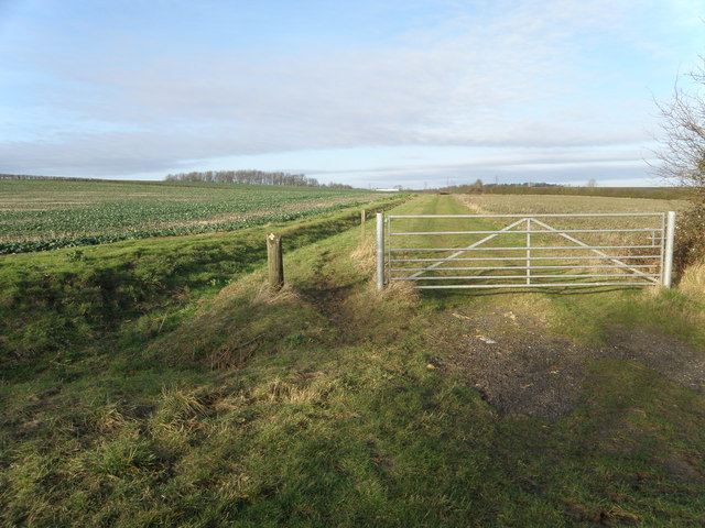
Cockway Lane An old track, gated for field access and serves as the path for the Three Shires long distance footpath and bridleway.
Cockway Lane
An old track, gated for field access and serves as the path for the Three Shires long distance footpath and bridleway.
Cockway Lane A westerly view of this ancient track way that carries the Three Shires Way.
Cockway Lane
A westerly view of this ancient track way that carries the Three Shires Way.
Byway to Stow Longa Junction on the Three Shires Way near Little Catworth.
Byway to Stow Longa
Junction on the Three Shires Way near Little Catworth.
Footpath to Little Catworth Access point along the Three Shires Way.
Footpath to Little Catworth
Access point along the Three Shires Way.
Along the Three Shires Way To the left is the Byway to Stow Longa. A superb walk even in December. French drains have been laid to aid drainage, new trees planted, the surface levelled and grassed down. Just the occasional wet muddy spot that can be traversed quite easily.
Along the Three Shires Way
To the left is the Byway to Stow Longa. A superb walk even in December. French drains have been laid to aid drainage, new trees planted, the surface levelled and grassed down. Just the occasional wet muddy spot that can be traversed quite easily.
Building on its last legs An old barn used for storing hay making kit including a Massey Ferguson Baler about to give up being a structure and become a ruin. Apologies for the post intruding but where ever I stood something draped across the field of view in what is a sneaky photo anyway.
Building on its last legs
An old barn used for storing hay making kit including a Massey Ferguson Baler about to give up being a structure and become a ruin. Apologies for the post intruding but where ever I stood something draped across the field of view in what is a sneaky photo anyway.
Three Shires Way just below Molly Rose Lodge
Recently planted trees by the Three Shires Way This part of the Three Shires Way has received a bit of a makeover with French drains installed, trees planted and overgrown scrub reined in.
Recently planted trees by the Three Shires Way
This part of the Three Shires Way has received a bit of a makeover with French drains installed, trees planted and overgrown scrub reined in.
Track to Molly Rose Lodge Part of the Three Shires Way
Track to Molly Rose Lodge
Part of the Three Shires Way
No Through Road Just happens to be facing the wrong way, pedestrian and horse access allowed as this is part of the Three Shires Way.
No Through Road
Just happens to be facing the wrong way, pedestrian and horse access allowed as this is part of the Three Shires Way.
Tilbrook Grange One of those unique farms where the road passes through the farmyard. The grain store is now complete <a href="https://www.geograph.org.uk/photo/747172">TL0871 : Grain Store Construction, Tilbrook Grange</a>
Tilbrook Grange
One of those unique farms where the road passes through the farmyard. The grain store is now complete TL0871 : Grain Store Construction, Tilbrook Grange
No Through Road Modern sign and old Pre-Worboys No Through Road sign near to Catworth, Cambridgeshire. For close up view see <a title="https://www.geograph.org.uk/photo/2883400" href="https://www.geograph.org.uk/photo/2883400">Link</a>
No Through Road
Modern sign and old Pre-Worboys No Through Road sign near to Catworth, Cambridgeshire. For close up view see Link
Pre-Worboys Sign Old Pre-Worboys No Through Road sign near to Catworth, Cambridgeshire. For overall view see <a title="https://www.geograph.org.uk/photo/2883397" href="https://www.geograph.org.uk/photo/2883397">Link</a>
Pre-Worboys Sign
Old Pre-Worboys No Through Road sign near to Catworth, Cambridgeshire. For overall view see Link
Old Milepost Old milepost on the B660 near to Catworth, Cambridgeshire. For overall view see <a title="https://www.geograph.org.uk/photo/2883405" href="https://www.geograph.org.uk/photo/2883405">Link</a>
Old Milepost
Old milepost on the B660 near to Catworth, Cambridgeshire. For overall view see Link
66 Miles From London Old milepost on the B660 near to Catworth, Cambridgeshire. For close up view see <a title="https://www.geograph.org.uk/photo/2883402" href="https://www.geograph.org.uk/photo/2883402">Link</a>
66 Miles From London
Old milepost on the B660 near to Catworth, Cambridgeshire. For close up view see Link
Track to Molly Rose Lodge The sign reads "No vehicles 1st October to 30th April"
Track to Molly Rose Lodge
The sign reads "No vehicles 1st October to 30th April"
Show me another place!

Bunkers Hill is located at Grid Ref: TL1071 (Lat: 52.332595, Lng: -0.37921192)

Administrative County: Cambridgeshire

District: Huntingdonshire

Police Authority: Cambridgeshire

What 3 Words

///droplet.snored.attaching. Near Kimbolton, Cambridgeshire

Nearby Locations

Bunkers Hill

Related Wikis

Stow Longa

Stow Longa is a village and civil parish in Cambridgeshire, England. Stow Longa lies approximately 8 miles (13 km) west of Huntingdon and two miles north...

Little Catworth Meadow

Little Catworth Meadow is a 5.2-hectare (13-acre) biological Site of Special Scientific Interest between Catworth and Spaldwick in Cambridgeshire.The meadow...

A142 road

The A142 is a road that runs from Newmarket in Suffolk to Chatteris in Cambridgeshire. == References ==

Kimbolton railway station

Kimbolton railway station was a railway station in Kimbolton, Cambridgeshire. The station and its line closed in 1959. The journey from London St. Pancras...

Have you been to Bunkers Hill?

Leave your review of Bunkers Hill below (or comments, questions and feedback).